All Activity
- Past hour
-
The cell near Moorefield, WV intensified relatively quickly. We'll see how things trend the next 1-2 hours.
-
 It will be interesting to see how this ultimately plays out. I suspect that the Sonoran Desert has yet to see its highest temperatures this summer, even if the forecast values for this week verify.
 -

E PA/NJ/DE Summer 2026 Obs/Discussion
Lucy Pull replied to PhiEaglesfan712's topic in Philadelphia Region
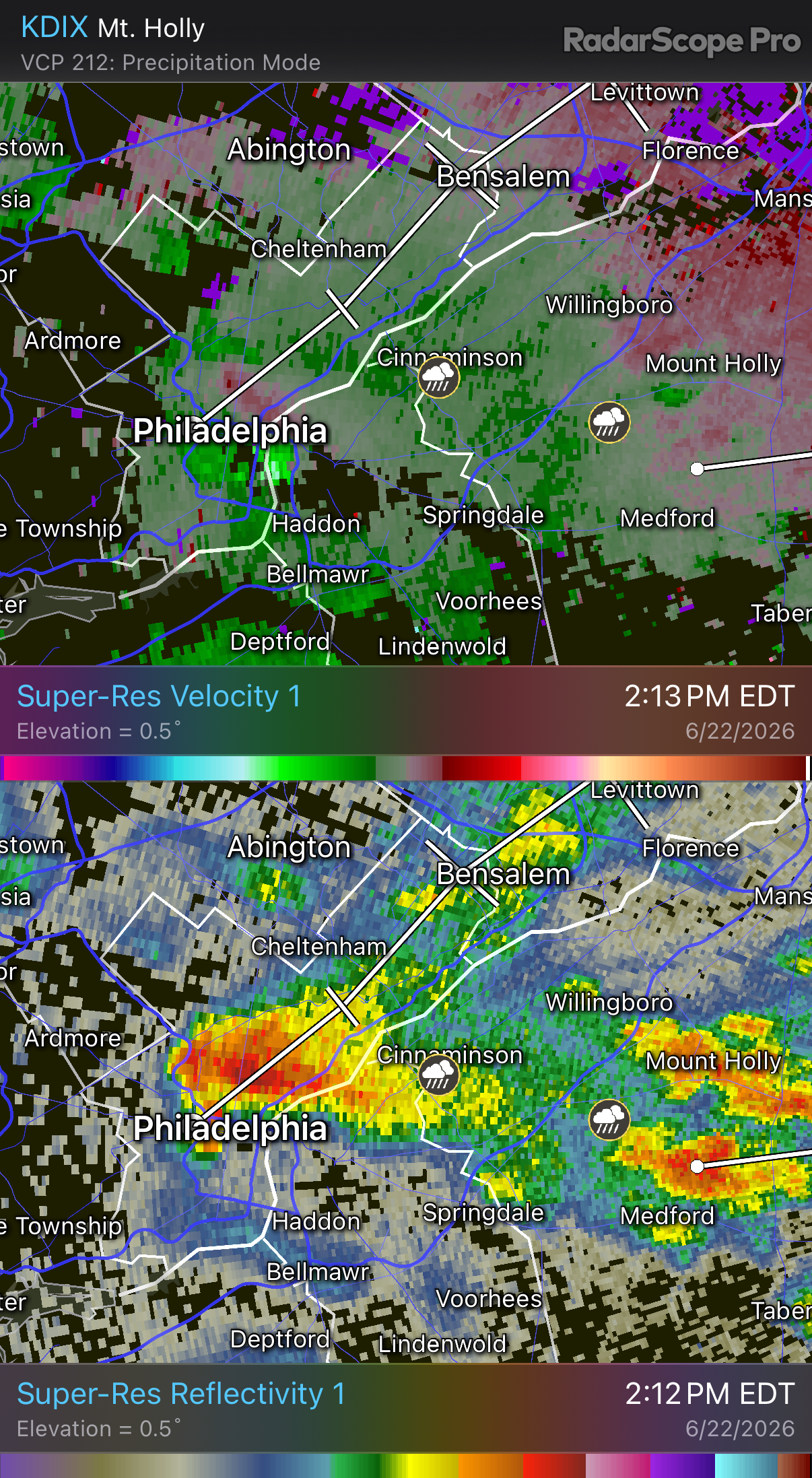
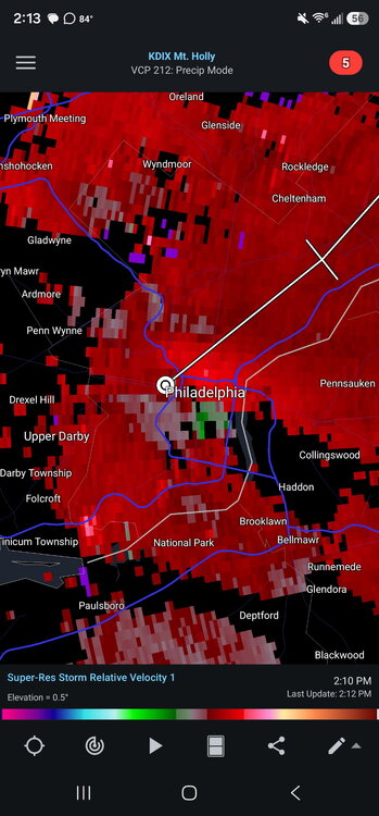
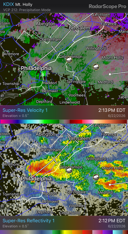
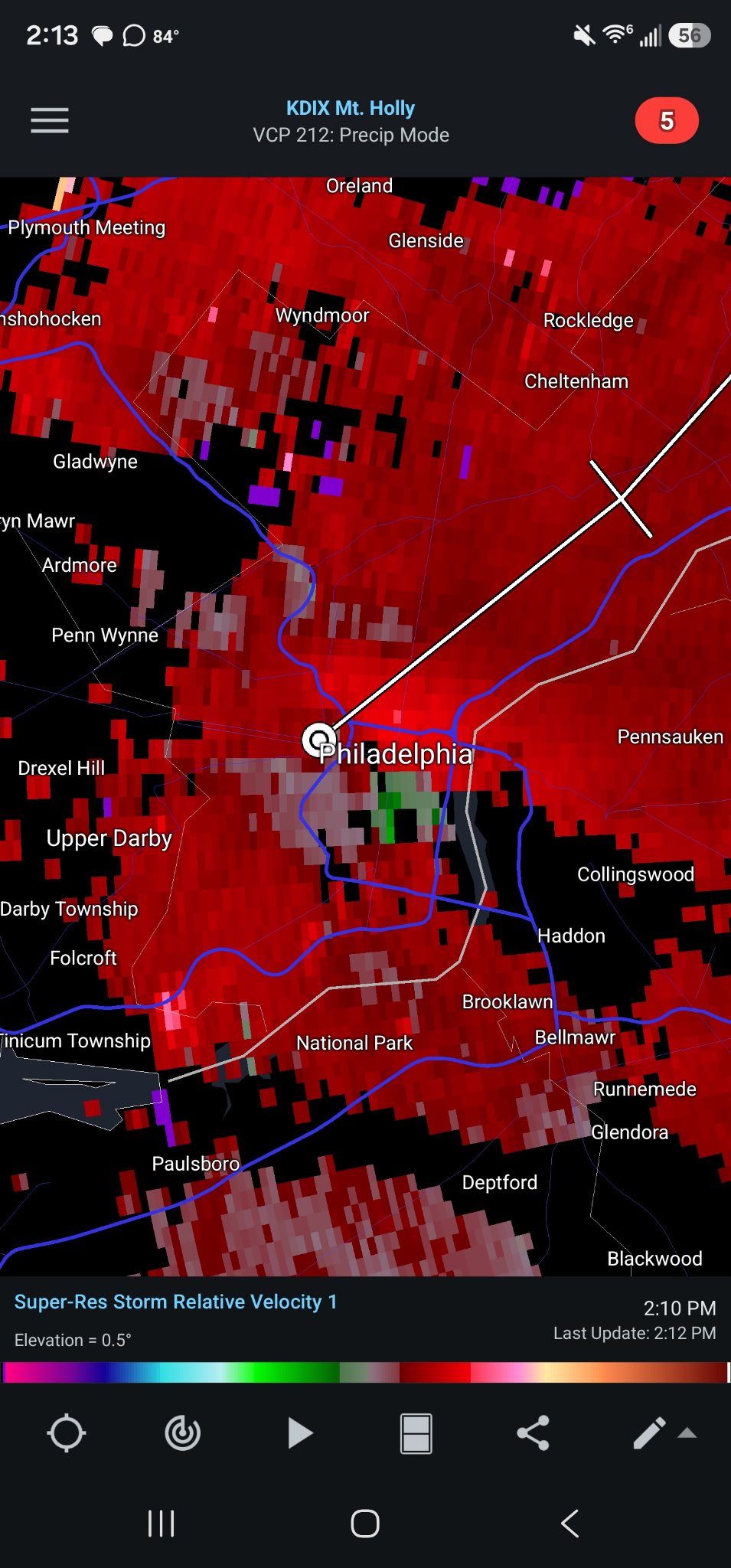
Definitely looks to have been a rotating storm that moved through Philly around 2:15. Not an overly tight couplet but decent storm structure. -

E PA/NJ/DE Summer 2026 Obs/Discussion
enpawx_observer replied to PhiEaglesfan712's topic in Philadelphia Region
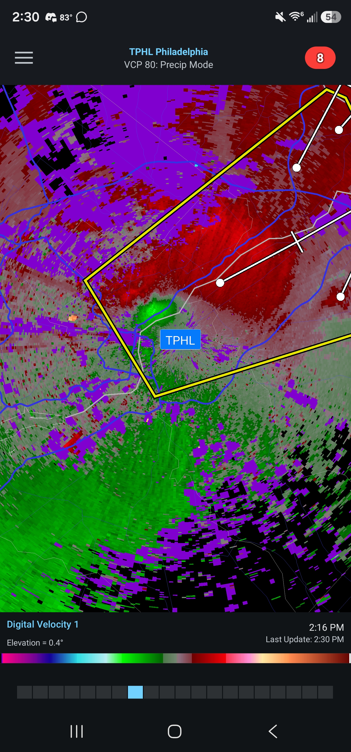
Guess that's why it got a tornado possible tag
-

2026 Spring/Summer Mountain Thread
Maggie Valley Steve replied to Buckethead's topic in Southeastern States
Heavy rain in the Valley. -
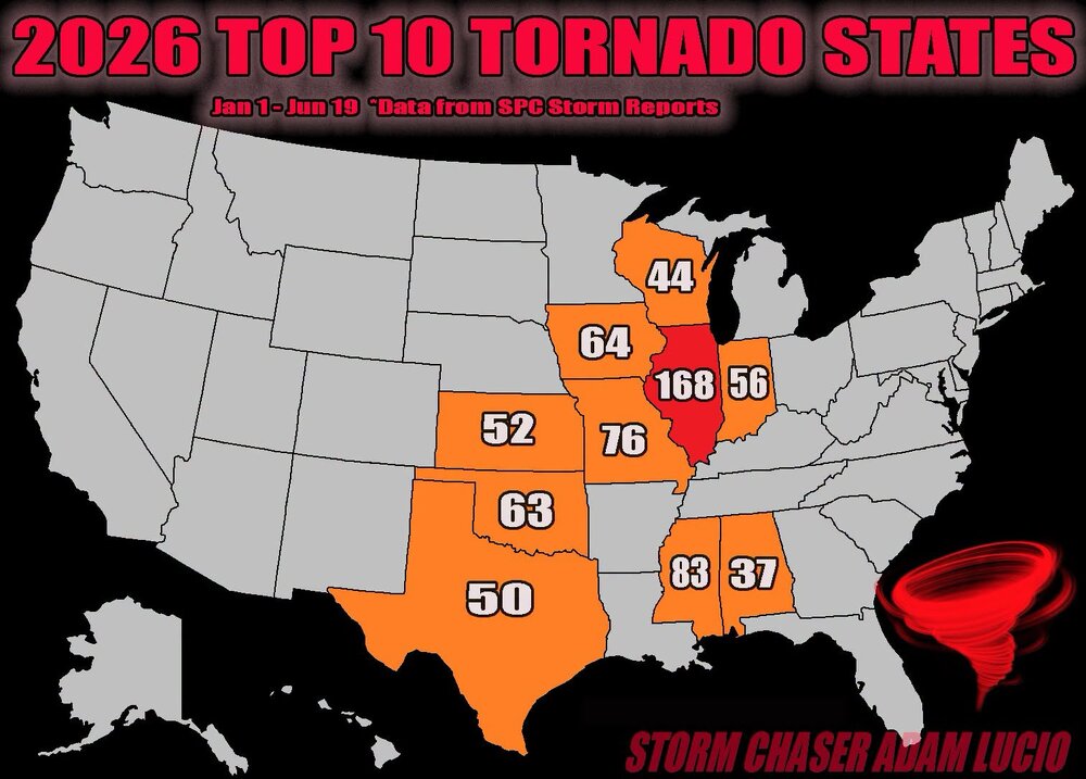
IL had 20+ tornado reports yesterday, and the state is now over 190 for the year (*reports*, not actual tornadoes, there are duplicate reports in this total). Attached is a map for the bigger state totals through 6/19. The disparity is amazing. Why IL only so much more? It's not like when an area is soaked or buried repeatedly w/ rain/snow. That is more on the synoptic level and areal coverage is larger. When you get down to a local level, such as an area that is about avg size for a U.S. state, that's not the same for scale. And to get tornadoes, it is a lot more conditional (harder) than say a lot of heavy rain or snow over an extended period. But given the vagaries of the atmosphere/patterns and given enough time, you are going to see things due to the law of large numbers and averages. Just pointing this out b/c some try to assign a specific meaning or cause, where sometimes there is none. Yes, I know of the hypothesis that tornado alley is shifting E, but we really do not have enough solid data IMHO. Tornadoes, esp. weak and short-lived ones, were severely under-counted prior to the 1990s since storm chasing was not yet mainstream, WSR-88Ds did not exist for operational use, nor did the Internet (at least in widespread use). ~35 years of data is not enough time to establish a trend either way. I would argue that it wasn't until 2010 or so when we started to get close to actual number of tornadoes that occur every year in the U.S. w/ the advent of the smartphone and dual-polarization radar.

-

E PA/NJ/DE Summer 2026 Obs/Discussion
Hurricane Agnes replied to PhiEaglesfan712's topic in Philadelphia Region
Thunderstorm Watches are up (am getting a lot of convection hits on my lightning detector) Also a warning over parts of Philly metro - Currently overcast and 78 with dp 69. -

2026-2027 Super El Nino
LakePaste25 replied to Stormchaserchuck1's topic in Weather Forecasting and Discussion
it’s why i always laugh when I see agencies such as AccuWeather or twitter accounts deterministically forecast seasonal snow totals in ENSO years like this. Above normal temps in the northeast and great lakes that fade towards neutral as you go south is a sure bet, but nobody can predict whether places like DCA will get a single storm that produces 150% of their seasonal totals. -
Occasional Thoughts on Climate Change
donsutherland1 replied to donsutherland1's topic in Climate Change
France sizzled under a heat dome that felt more like a fire dome today. More than 300 locations reached 40C (104F) or above, 123 all-time records were set, and an additional 453 monthly records were set.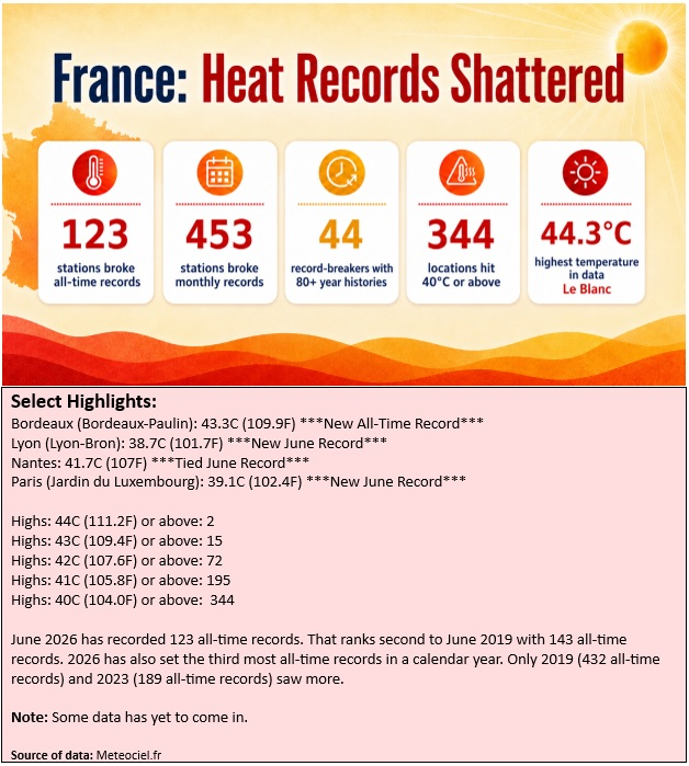
-
IL had 20+ tornado reports yesterday, and the state is now over 190 for the year (*reports*, not actual tornadoes, there are duplicate reports in this total). Attached is a map for the bigger state totals through 6/19. The disparity is amazing. Why IL only so much more? It's not like when an area is soaked or buried repeatedly w/ rain/snow. That is more on the synoptic level and areal coverage is larger. When you get down to a local level, such as an area that is about avg size for a U.S. state, that's not the same for scale. And to get tornadoes, it is a lot more conditional (harder) than say a lot of heavy rain or snow over an extended period (CoastalWx would disagree about the heavy snow!). But given the vagaries of the atmosphere/patterns and given enough time, you are going to see things due to the law of large numbers and averages. Just pointing this out b/c some try to assign a specific meaning or cause, where sometimes there is none. Yes, I know of the hypothesis that tornado alley is shifting E, but we really do not have enough solid data IMHO. Tornadoes, esp. weak and short-lived ones, were severely under-counted prior to the 1990s since storm chasing was not yet mainstream, WSR-88Ds did not exist for operational use, nor did the Internet (at least in widespread use). ~35 years of data is not enough time to establish a trend either way. I would argue that it wasn't until 2010 or so when we started to get close to actual number of tornadoes that occur every year in the U.S. w/ the advent of the smartphone and dual-polarization radar.
-
OooOOOh....RED. A 40-50% chance that we might be above normal. Could be 0.1 above normal, or +15 above normal, or not above normal at all.
-
Cell by Cherry Hill in southern NJ just went severe warned with 60 mph winds and penny size hail
-

2026-2027 Super El Nino
PhiEaglesfan712 replied to Stormchaserchuck1's topic in Weather Forecasting and Discussion
2009-10 had close to a neutral PDO. I'd definitely sign up for it if this upcoming winter was a neutral to slightly positive PDO and a -NAO. -
The watch has been issued.
- 833 replies
-
- 2
-

-
- severe
- thunderstorms
- (and 7 more)
-
Pretty decent rotation on the one cell that popped up over PHL moving NE
-

Central PA Summer 2026 Discussion/Obs Thread
mahantango#1 replied to Voyager's topic in Upstate New York/Pennsylvania
SEVERE THUNDERSTORM WATCH OUTLINE UPDATE FOR WS 375 NWS STORM PREDICTION CENTER NORMAN OK 210 PM EDT MON JUN 22 2026 SEVERE THUNDERSTORM WATCH 375 IS IN EFFECT UNTIL 900 PM EDT FOR THE FOLLOWING LOCATIONS PAC001-011-017-029-041-043-045-055-057-061-067-071-075-087-091- 099-101-133-230100- /O.NEW.KWNS.SV.A.0375.260622T1810Z-260623T0100Z/ PA . PENNSYLVANIA COUNTIES INCLUDED ARE ADAMS BERKS BUCKS CHESTER CUMBERLAND DAUPHIN DELAWARE FRANKLIN FULTON HUNTINGDON JUNIATA LANCASTER LEBANON MIFFLIN MONTGOMERY PERRY PHILADELPHIA YORK $$ -

2026-2027 Super El Nino
snowman19 replied to Stormchaserchuck1's topic in Weather Forecasting and Discussion
That didn’t last long….SOI right back down to almost -20 -
Heavy Pop-up shower here in Melville.
-

Junorch obs and discussion 2026
Damage In Tolland replied to Damage In Tolland's topic in New England
Torch !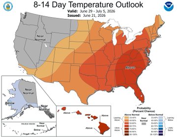
-
Brief shower, just enough rain to wet the laundry I had hanging outside
-

2026 Mid-Atlantic Severe Storm General Discussion
SnowenOutThere replied to Kmlwx's topic in Mid Atlantic
I’m sorta feeling today. At the bare minimum we’re over 1000 SCAPE right now so I think we will at least get some storms this evening. -
If I was any good at stats I'd tot the anomaly from the state avg, and the sigmas. Its been a long time since OH valley has been the center of the action; I ken when I was young tornado alley included IL, IN, OH.
-
HRRR has been showing some very heavy rain for a little south of NYC, and we can see that storm on radar now. Looks like some heavy stuff will be going into Mercer, Middlesex and Monmouth. It might miss me to the south but it's going to be close.
-
It's backfilling a little bit, and pouring here. We'll see what the rest of it as it swings in from the SW. NNJ looks like it's got a shot maybe.
-

2026 Mid-Atlantic Severe Storm General Discussion
batmanbrad replied to Kmlwx's topic in Mid Atlantic
for those hoping for at least drought-denting rainfall, WPC shares some decent possibilities in their latest ERO/ERD: ...Central Appalachians to Northeast U.S... Surface low currently analyzed over the western Ohio Valley will gradually lift to the east-northeast with an expectation for the low center to exit off the northern Mid Atlantic coast, dragging a cold front through the Mid Atlantic and Ohio Valley and lifting a warm front ahead of the disturbance. The current indications are for convection to spawn over the eastern Ohio Valley by the early- afternoon as mid-level ascent and increased surface forcing aided by the cold front and area of low pressure will trigger convective initiation just upstream of the terrain in WV and western PA. This area of thunderstorms will migrate eastward, entering a favorable environment within a modest warm sector as you move east of the Appalachian front. Shear profiles across the Mid Atlantic are anticipated to be greatest north of the Mason Dixon, however shear magnitudes are still capable for enabling stronger mid-level mesocyclones to materialize and hold as far south as I-66 leading to prospects for heavier thunderstorms to hold across the urban corridor extending from northern VA up through NYC and western LI. HREF probs for >1" are pretty high for both the neighborhood and EAS fields meaning there's a consensus for areas of heavy rainfall to impact much of the Mid Atlantic with the most pronounced signatures into the Central Appalachians and the urban centers, both are which are susceptible to flash flood concerns. Antecedent soil moisture is dry, so the initial burst of rainfall will be beneficial to those areas not tied completely by urban infrastructure, however, there's a sufficient signal in the QPF means to maintain the previous SLGT risk inherited for the region as 00z CAMs maintained their depictions on a multi-round cycle of convection moving into the area with pockets of 2-3+" forecast across portions of the aforementioned areas.


.thumb.jpeg.f5c6ba9d911ec96b3b124f8606aee58e.jpeg)