All Activity
- Past hour
-

Jan 24-26 Weekend Snow and Sleetfest Model Thread Part Tres
Eskimo Joe replied to H2O's topic in Mid Atlantic
Yea the 18z HRRR is definitely colder and wetter. More snow for I-95 and points north and west. More sleet than ZR for southern MD too. -

January 24-26: Miracle or Mirage JV/Banter Thread!
SBYWeather replied to SnowenOutThere's topic in Mid Atlantic
I decided since we are only going to get a brief front end thump then sleet then plain rain here on the eastern shore I am heading up to Blue Knob in Pa to ride out this storm and do some skiing! I already had a place there Wed-Sun so decided to just head up tomm am and spend the week. Hoping for 12"+ on the mountain! -

Pittsburgh/Western PA WINTER ‘25/‘26
colonel717 replied to Burghblizz's topic in Upstate New York/Pennsylvania
-
It is not easy reaching blizzard criteria. In this case, the GFS, NAM and NAMnest soundings in the Lehigh Valley do show some wind however it is not ideal mixing. I am not sold on actual blizzard conditions occurring.
-
The lp is in NC still only 32 in loudon where I am and raining
-
This is for the border but this will end up playing a major factor in this storm as well. HIGH WIND WARNING IN EFFECT FROM 7 PM SATURDAY TO 7 PM EST SUNDAY... * WHAT...Southeast winds 20 to 30 mph with gusts up to 60 mph expected. * WHERE...Blount Smoky Mountains, Cocke Smoky Mountains, Sevier Smoky Mountains, Southeast Carter, Southeast Greene, Southeast Monroe, and Unicoi Counties. * WHEN...From 7 PM Saturday to 7 PM EST Sunday.
-
I liked it first. Its another Cape storm. The last one was a bit underwhelming, but a prelude to the one that's on our doorstep.
-

Pittsburgh/Western PA WINTER ‘25/‘26
Mailman replied to Burghblizz's topic in Upstate New York/Pennsylvania
.DISCUSSION... KEY MESSAGE 1... The Winter Storm Warning continues. Significant snow accumulations are still forecast, but sleet and freezing rain chances have increased in the ridges, particularly in northern West Virginia. The large-scale pattern as advertised by the model suite has not changed significantly with the upcoming winter storm. An Arctic cold front currently dropping across the region with a thin band of snow showers will have the main impact of introducing a very cold air mass back to the region. Upstream, shortwaves originating over the northern Plains and southern Rockies will begin to phase as they approach the Mississippi River Valley Sunday/Sunday night. Surface low pressure develops along the Gulf Coast Saturday night and lifts northeastward on Sunday, eventually handing off to a developing Atlantic Coast low by Monday morning. Inverted troughing pokes northward into the Middle and Upper Ohio Valley Saturday night and Sunday. On the eastern side of this, southeast flow and a decent southerly 850mb jet will support warming aloft mainly to the south and east of Pittsburgh on Sunday. With increased confidence in this, greater coverage and amounts of freezing rain and sleet have been introduced. This is particularly true in the higher terrain of northern West Virginia, where one to two tenths of ice accretion may occur, along with a period of sleet. This has cut down the snow accumulations in this region. Overall, moisture and lift remain impressive overall with this system. We still expect a coupled upper jet structure, layered frontogenesis, and the inverted trough to support strong lift. Precipitable water is forecast to reach around the 90th percentile level as compared to late January climatology as well. So, overall liquid equivalent totals of 1 to 2 inches are still a good bet. With the further northward extent of warm air aloft, snow-to-liquid ratios have trended down slightly, which was the main factor in lowering storm total snowfall amounts. Nevertheless, a widespread significant snowfall is still forecast across the region with high confidence. Here are the latest 48-hour ensemble-based probabilities for 48-hour snow totals through 7 AM Monday. They are similar to previous model runs overall, but probabilities for the higher- end accumulations have decreased slightly: 15":10-50% 12":50-80% 8": 75-95% 6": 85-100% 4": 95-100% Given the lower expected SLRs, there remains a decent chance of a heavier, wetter snow, especially near and south of Pittsburgh. Also, given low SLRs and increased chances for freezing rain, the chance of power outage impacts is increasing in the higher elevations, particularly in northern West Virginia. We will need to continue to monitor precipitation-type trends and adjust accordingly. However, there is high confidence in Winter Storm Warning-level impacts in any case. The timing of the heaviest snow still appears to be during Sunday morning south of I-70, and late morning Sunday through Sunday evening north of I-70. Cold northwesterly flow and the crossing parent upper trough could result in lingering snow into Monday. Continue to monitor the latest forecasts as this system approaches, as widespread impacts to travel and daily life are highly likely Sunday into Monday. -

Jan 24-26 Weekend Snow and Sleetfest Model Thread Part Tres
NorthArlington101 replied to H2O's topic in Mid Atlantic
DC looks to flip after 11am. Currently on the pre-flip-to-sleep-rippage panel. -

Jan 24-26 Weekend Snow and Sleetfest Model Thread Part Tres
bncho replied to H2O's topic in Mid Atlantic
SE DC loses thermals at hr 46, NW DC and burbs holding on... -

E PA/NJ/DE Winter 2025-26 Obs/Discussion
Chadzachadam replied to LVblizzard's topic in Philadelphia Region
Casual 3’ of snow in southern Alabama next weekend on the gfs currently enjoying my last few hours of above freezing temps for the next 10 days… -

“Cory’s in LA! Let’s MECS!” Jan. 24-26 Disco
Typhoon Tip replied to TheSnowman's topic in New England
Wtf ... Channel 7/NBC affiliate out of Boston is buckin' for a 24-36" of eastern Mass ??!! tell me that's some kid with a free afternoon and a chapgpt meme kit -

January 25-26 Winter Storm Potential
Birds~69 replied to Ralph Wiggum's topic in Philadelphia Region
6abc/accu weather not too long ago. I'll sign and let's get this show on the road...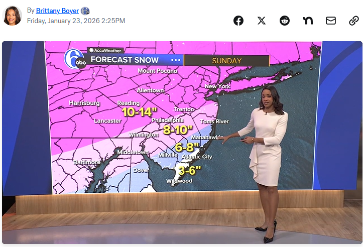
-

January 25-26 Winter Storm Potential
The Iceman replied to Ralph Wiggum's topic in Philadelphia Region
-
holy sheet
-
Jan 24-26 Weekend Snow and Sleetfest Model Thread Part Tres
bncho replied to H2O's topic in Mid Atlantic
I think HRRR might lose thermals soon but if it holds out until the end of its run then DC gets 10" -
18z HRRR ups Ice totals up a tick .
-
They might've postponed it for fan safety.
-
3/4 inch of ice? I'm a lurker and a super n00b but isnt that approaching biblically bad?
-
Pittsburgh/Western PA WINTER ‘25/‘26
colonel717 replied to Burghblizz's topic in Upstate New York/Pennsylvania
50 for 50... All good. Been consistently that way for couple days. -
I guess. He just literally never won anything. Even at Texas Tech as coach. I just hate people who can’t win the big game. I will say he was severely handicapped this season. Maybe with a mobile QB like he had with Daniels, he can make it work. I’ll be skeptical until I’m not lol So long as we don’t hire Matt Nagy….
-

January 24-26: Miracle or Mirage JV/Banter Thread!
snowfan replied to SnowenOutThere's topic in Mid Atlantic
Please do not forget to be telework ready on Monday to support the mission. -

Possible Record Breaking Cold + Snow Sunday 1/25 - Tuesday 1/27
SACRUS replied to TriPol's topic in New York City Metro
1/23 18Z nam is updating -

Texas 2026 Discussion/Observations
canderson replied to Stx_Thunder's topic in Central/Western States
Ice storms in ET are awful. Don’t wish them on anyone. -

January 24-26: Miracle or Mirage JV/Banter Thread!
LeesburgWx replied to SnowenOutThere's topic in Mid Atlantic
Lmao no, someone was looking at models in there. I couldn’t ask if they are on here because I had to leave for an appointment coming up


