All Activity
- Past hour
-
 http://dermatretdirect.com/# isotretinoin online prescription free
-
Yeah I used beta only for off runs of the Euro... they gave it to us for free.
-

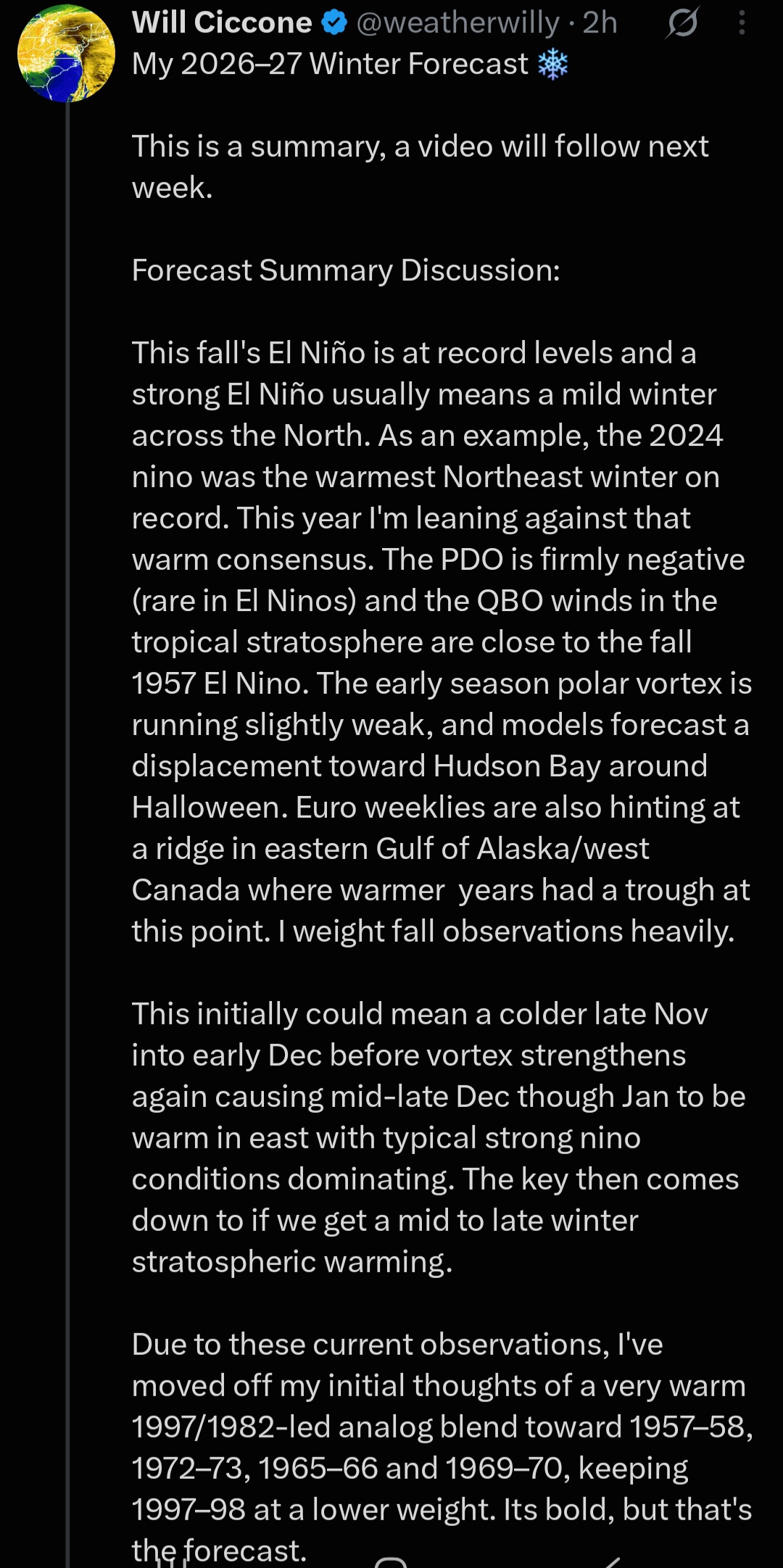
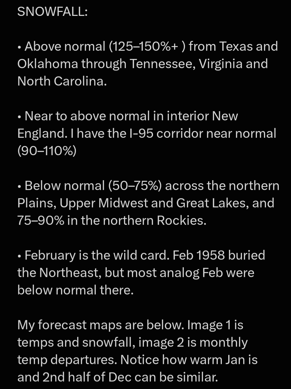
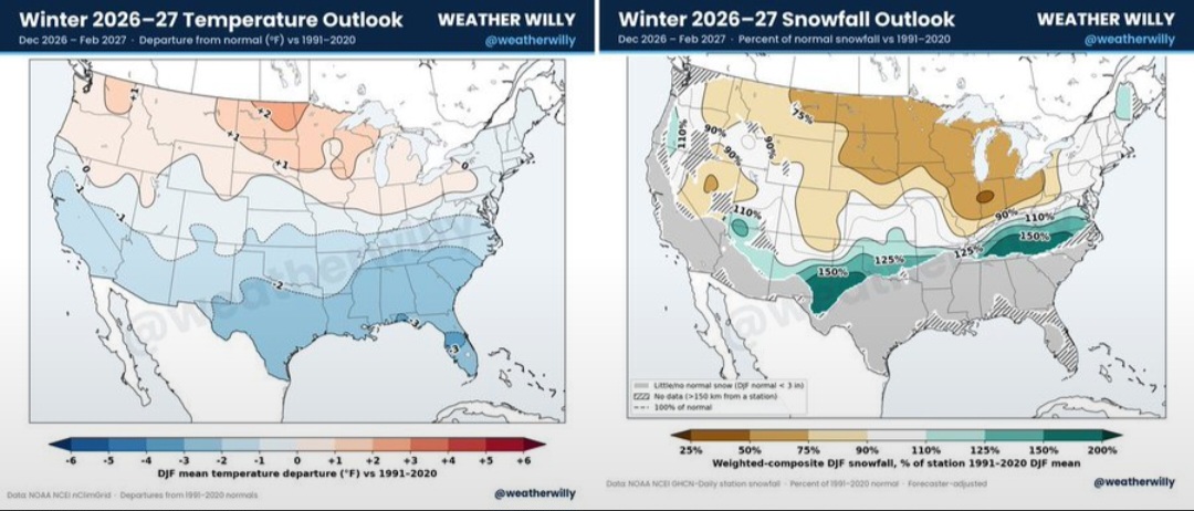
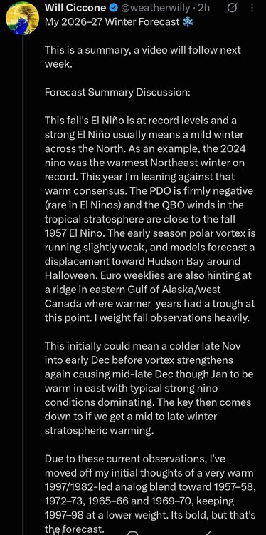
2026-2027 Record-breaking El Nino
LakePaste25 replied to Stormchaserchuck1's topic in Weather Forecasting and Discussion
I disagree. There’s a decent chance that someone between the upper Midwest and Northeast is going to get a +10 December. Sure, not everyone, and it all depends on where the MJO is at in a month. -
Yep, and now back to our regularly scheduled best October ever.
-
It’s been in beta for a while, was using it last winter in beta. You get use to it
-
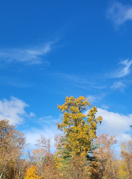
This stretch of weather is the longest I've remembered where there hasn't been a cloud in the sky and it's been severe clear for such a prolonged period with a locked in pattern.
-

2026-2027 Record-breaking El Nino
Keith Central PA replied to Stormchaserchuck1's topic in Weather Forecasting and Discussion
A near normal December is not happening, but neither is a +10..Acutally anybody would take normal snowfall at this point. -
Seems we might have a + NAO October, I believe thats a good thing.
-
There has always been high variability around xmas. However, it's skewing more and more the wrong way. Prior to 2010 the median high in DC on December 25th was 42. Since 2010 the median high is 51. From 1945 to 2009 DC had snow on the ground 13 times. It has now been 16 years since there was snow recorded OTG on xmas. There is always variability, but within the variability is a trend. December is the Winter month most affected by warming. Both in Temps and Snowfall. We are losing it as a winter month basically. It is what it is. We have lost about 18% of our snowfall climo in the last 50 years and December accounts for most of that loss.
-
Stunning autumn weather for outdoor work. I'm sure someone will chime in with drought talk again by next week.
-

2026-2027 Fall/Winter Mountain Thread
calculus1 replied to BlueRidgeFolklore's topic in Southeastern States
I love that little hike to Little Lost Cove Cliffs, but I like the one to Big Lost Cove Cliffs, just higher up that same forest road, even better. Both have excellent views of Grandfather and the Wilson Creek drainage basin. Thanks for sharing that beautiful picture. -
-
Low of 44 after 3 nights of 36,35.5 and 38
-

Winter 2026-2027 Seasonal Outlook
GaWx replied to WinstonSalemArlington's topic in Southeastern States
The CFSv2 for the last 2 months worth of daily 10 day mean runs has been persistent in showing Feb ‘27 to have an extreme couplet of a much warmer than normal E Canada and a cold dominant CONUS. No other mid-Oct. 10 day CFSv2 mean (back to 2012, its first one) has shown anything anywhere close to this, which has not only 80% of Conus BN but also a very mild E Canada acting as a very strong block: In this post in the main forum, I compared this mid-Oct CFSv2 forecast to all other CFSv2 mid-Oct forecasts for Feb (back to first one for Feb ‘12) and its implications regarding what may actually happen in Feb ‘27: Aside: @buckeyefan1would you mind pinning this winter outlook thread? It is getting relatively little viewing and thus few posts (only 50 in 6 months) due to being so far down on the topics list even after a recent post since 5 other threads have already been pinned.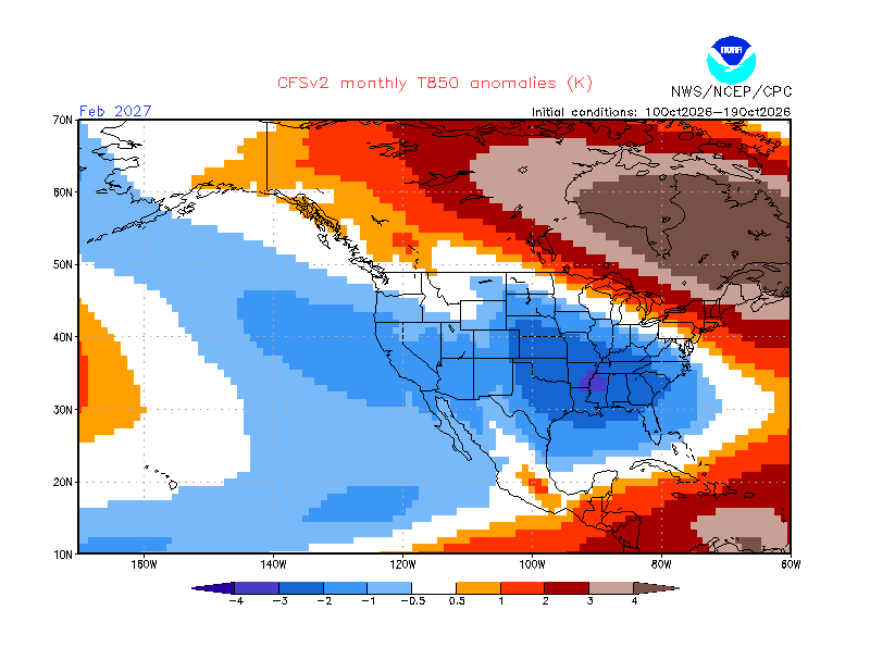
-
Reminds me of that one summer a few years ago where the skies were cloudless for like two weeks. It was insane. First time in my life experiencing that.
-

E PA/NJ/DE Autumn 2026 Obs/Discussion
Birds~69 replied to PhiEaglesfan712's topic in Philadelphia Region
Raking leaves? Trees are generally still full w/some signs of color change around here. If a human actually included/wrote that...he/she is clueless. 56F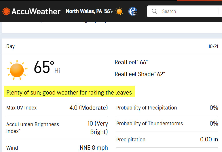
-
October 21 1916: A three-day blizzard ends. Also, a sharp temperature drop occurs at Bird Island, falling from 65 to 13. For Wednesday, October 21, 2026 1934 - A severe windstorm lashed the northern Pacific coast. In Washington State, the storm claimed the lives of 22 persons, and caused 1.7 million dollars damage, mostly to timber. Winds, gusting to 87 mph at North Head WA, produced waves twenty feet high. (David Ludlum) 1957 - The second in a series of unusual October storms hit southern California causing widespread thunderstorms. Santa Maria was drenched with 1.13 inches of rain in two hours. Hail drifted to 18 inches in East Los Angeles. Waterspouts were sighted off Point Mugu and Oceanside. (20th-21st) (The Weather Channel) 1987 - Cold arctic air continued to invade the central U.S. Eleven record lows were reported in the Great Plains Region, including lows of 12 degrees at Valentine NE, and 9 degrees at Aberdeen SD. Temperatures warmed rapidly during the day in the Southern and Central Plains Region. Goodland KS warmed from a morning low of 24 degrees to an afternoon high of 75 degrees. (The National Weather Summary) 1988 - Joan, the last hurricane of the season, neared the coast of Nicaragua packing 125 mph winds. Joan claimed more than 200 lives as she moved over Central America, and total damage approached 1.5 billion dollars. Crossing more than 40 degrees of longitude, Hurricane Joan never strayed even one degree from the 12 degree north parallel. (The National Weather Summary) (Storm Data) 1989 - Unseasonably cold weather continued to grip the south central and southeastern U.S. Twenty cities reported record low temperatures for the date, including Calico AR with a reading of 26 degrees, and Daytona Beach FL with a low of 41 degrees. Squalls in the Great Lakes Region finally came to an end, but not before leaving Marquette MI buried under 12.7 inches of snow, a record 24 hour total for October. (The National Weather Summary) Observances: 21 Wed National Pets for Veterans Day 21 Wed Back to the Future Day 21 Wed Global Dignity Day 21 Wed National Apple Day 21 Wed National Reptile Day 21 Wed National Medical Assistants Day 21 Wed American Frog Day 21 Wed Celebration of the Mind Day 21 Wed Count Your Buttons Day 21 Wed Everyone Writes Day 21 Wed National Archives Day 21 Wed National Check Your Meds Day 21 Wed National Pumpkin Cheesecake Day 21 Wed Reptile Awareness Day 21 Wed Global Iodine Deficiency Disorders Prevention Day 21 Wed Get to Know Your Customers Day
-
My station isn't in a dendrite-advised-or-approved location so the direct sun likely skews the temp a bit, but it was a fabulous day nonetheless!
-
Gotta say...the bots have been quite impressive with pattern recognition and just an overall better idea of the general idea of the larger-scale storm details (development, track). Certainly enough I think to give a big boost in confidence for medium-range forecasting. Not entirely sure about the inside 48-hours or storm specific details but they've been a big boost in the medium-range for sure.
- Today
-
the epac is warmer than the wpac. that's outrageous
-
unfortunately
-
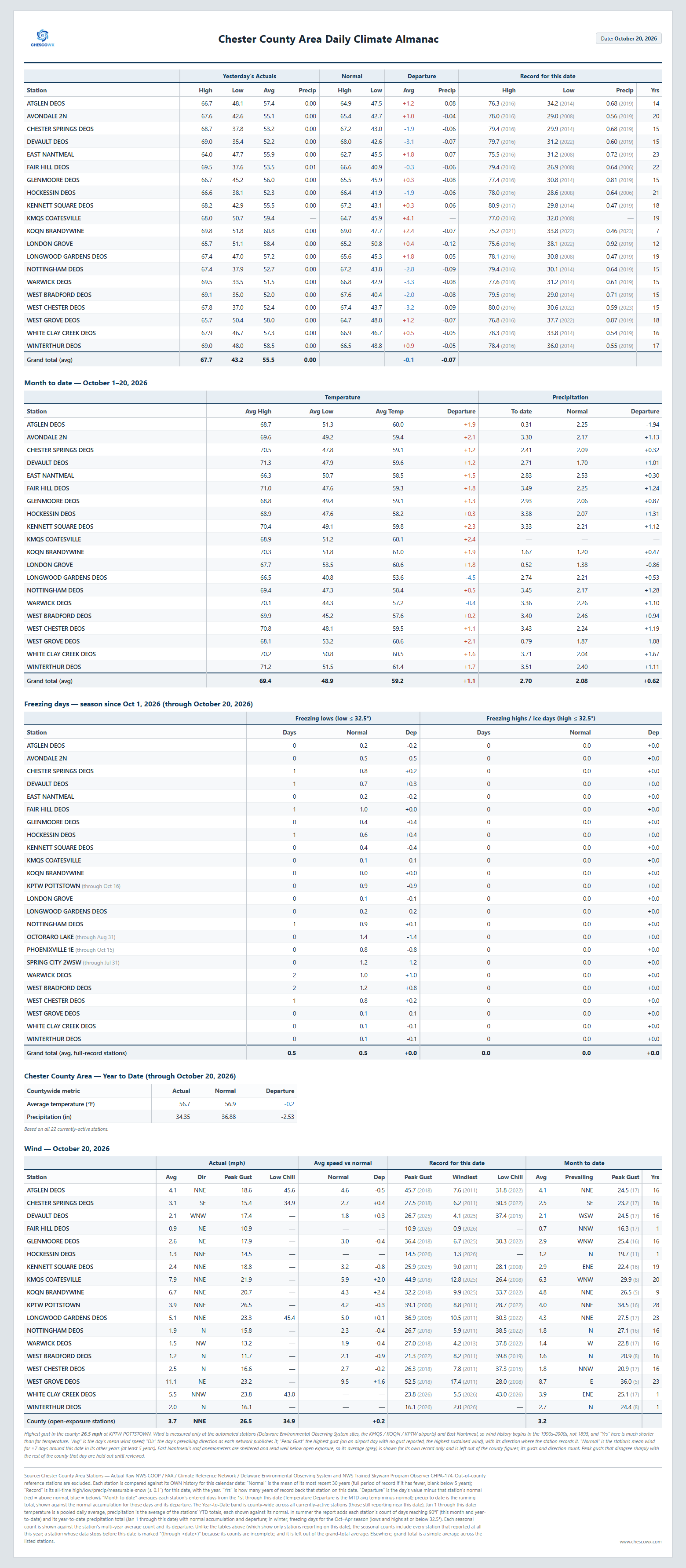
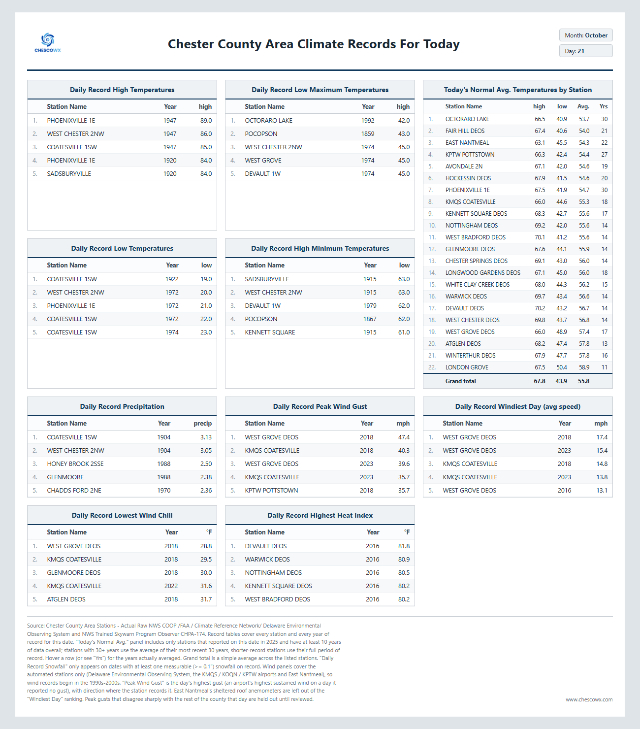
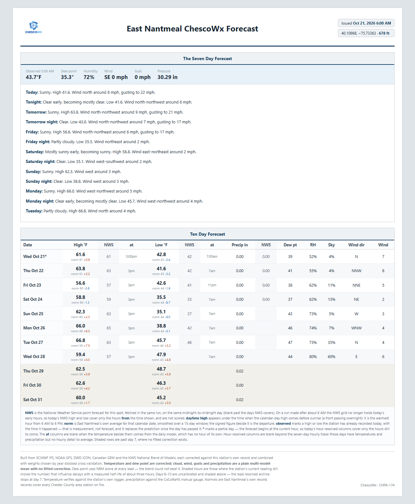
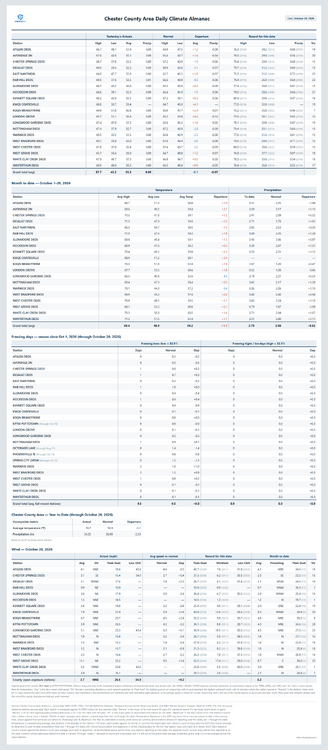
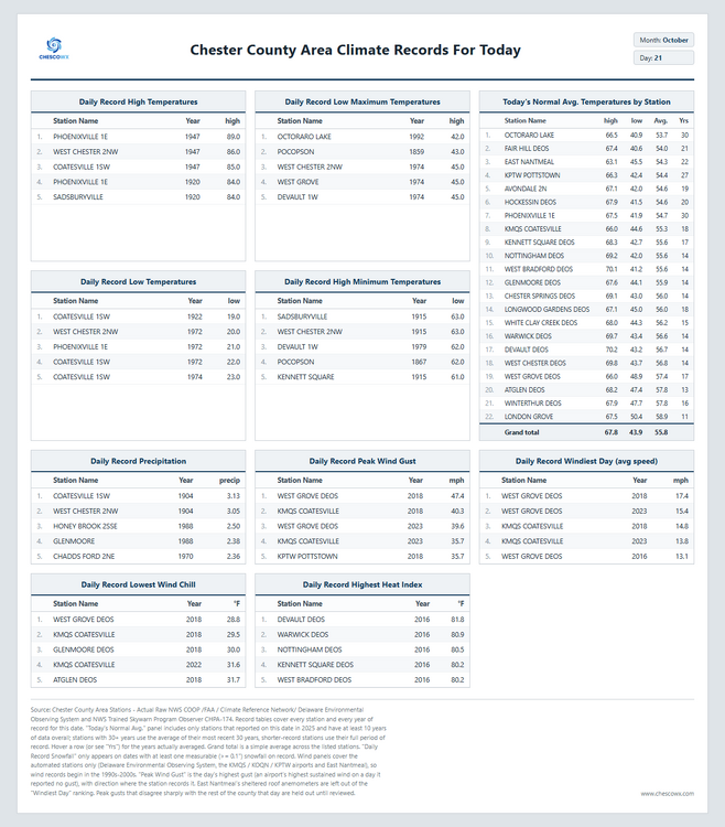
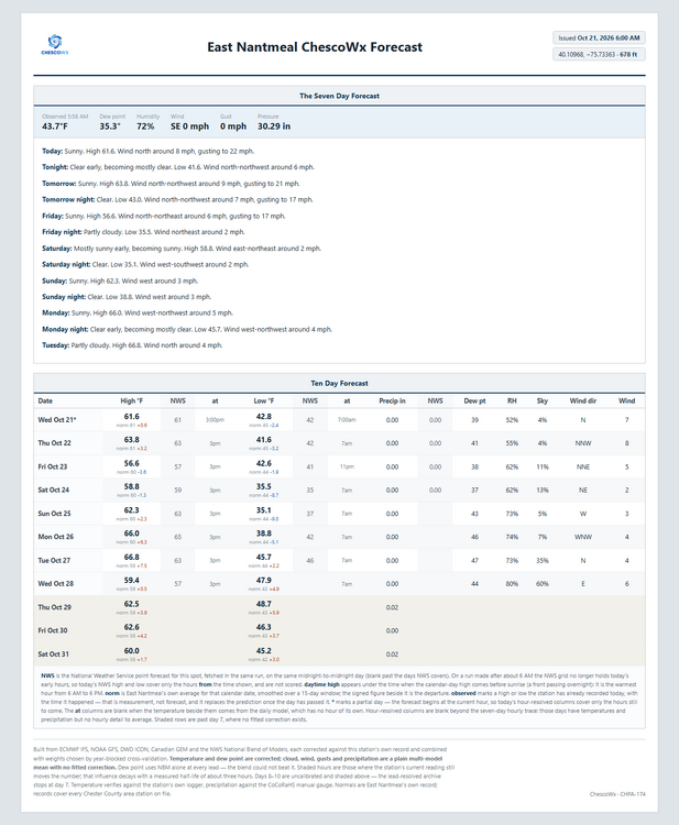
Today we should see highs from low 60's in ridge locations to the mid 60's in valley spots with lows tonight in the upper 30's to low 40's. It should be one of the better weather weeks of the year with almost no chance of rain. By Sunday morning we should see lows in the low to mid 30's with a freeze possible in the colder valleys! Temperatures will be near normal through Friday but this weekend we drop to about 5 degrees below normal, before we return to near normal by Monday. Of note 82 years ago today back in 1944 the Chester County Area was at the start of a 2 day storm that left as much as 1.63" of rain at Phoenixville 1E. This was the remnants of an unnamed hurricane which tracked within about 120 miles of the county.
-

E PA/NJ/DE Autumn 2026 Obs/Discussion
ChescoWx replied to PhiEaglesfan712's topic in Philadelphia Region
Today we should see highs from low 60's in ridge locations to the mid 60's in valley spots with lows tonight in the upper 30's to low 40's. It should be one of the better weather weeks of the year with almost no chance of rain. By Sunday morning we should see lows in the low to mid 30's with a freeze possible in the colder valleys! Temperatures will be near normal through Friday but this weekend we drop to about 5 degrees below normal, before we return to near normal by Monday. Of note 82 years ago today back in 1944 the Chester County Area was at the start of a 2 day storm that left as much as 1.63" of rain at Phoenixville 1E. This was the remnants of an unnamed hurricane which tracked within about 120 miles of the county.
-

2026-2027 Record-breaking El Nino
snowman19 replied to Stormchaserchuck1's topic in Weather Forecasting and Discussion
-
I feel like the robots are winning this. Another test is that big typhoon out in the west pac. Seems like bots are winning, but bots sort of moved towards the physical models with that.