All Activity
- Past hour
-

January 30th- Feb 1st ULL and coastal storm obs
KrummWx replied to JoshM's topic in Southeastern States
Good question especially as a Trianglite....probably stay up til like 2am getting drunk playing poker and then check outside any time i wake up to take a leak ahaha. first sign of stickage i stay up -
28 degrees moderate to light snow currently. Laying immediately.
-

Possible coastal storm centered on Feb 1 2026.
Damage In Tolland replied to Typhoon Tip's topic in New England
Can we still get accumulating snow farther west ? -

January 30th- Feb 1st ULL and coastal storm obs
btownheel replied to JoshM's topic in Southeastern States
Is is directly over the top of that or does it develop downstream of a feature like that? Apologies, very MBY of me but the top of that is right over my head here on the Alamance/Guilford line. Wouldn’t mind a micro feature like that to “dry slot” proof us early! . -

Jan 30th-February 1st 2026 Arctic Blast/ULL Snow OBS Thread.
housemtnTN replied to John1122's topic in Tennessee Valley
Dime to nickel size clumps and heavy out my way. -

2025-2026 Fall/Winter Mountain Thread
Maggie Valley Steve replied to Buckethead's topic in Southeastern States
Light snow and 28. Already a dusting including the driveway. -
Where are you located roughly? I grew up in Mt Airy
-

Arctic Hounds Unleashed: Long Duration Late January Cold Snap
ORH_wxman replied to WxWatcher007's topic in New England
ORH did indeed tie the record low max of 10F in 1934. Kind of a weak vulnerable record but tied nonetheless. -
Where's the subtitle?
-
Jan 30th-February 1st 2026 Arctic Blast/ULL Snow OBS Thread.
Scottie16 replied to John1122's topic in Tennessee Valley
Heavy Flurry storm in Sweetwater. 31• 24DP . -
Possible coastal storm centered on Feb 1 2026.
ORH_wxman replied to Typhoon Tip's topic in New England
Don’t forget Leo too. Also in NS. -
Can I say it? WRAL post Fishel isn’t really worth paying much attention to. .
-

February 2026 Medium/ Long Range Discussion: Buckle Up!
mitchnick replied to Weather Will's topic in Mid Atlantic
Great beach weekend at KD Hills. https://forecast.weather.gov/MapClick.php?lon=-75.664&lat=36.013 -
January 30th- Feb 1st ULL and coastal storm obs
NCBlizzard replied to JoshM's topic in Southeastern States
37°F in Belmont, NC. Pumped to see any amount of snow, truly. What's everyones plan for sleep haha. I think I am going to try a brief nap here soon, waking up around 3-4 AM as of now, don't want to miss a moment - worried I'll end up just staying up all night and tomorrow! -
Some snow showers may get in around 7am
-
Yea, look at radar time. I still think ric gets to a warning
-
20 for the high and just 21 at DCA Its not rare to get a 2-3 day shot like this or colder but 7 + days is rare and this might be coldest 10 day stretch since the immortal 1977
-

The “I bring the mojo” Jan 30-Feb 1 potential winter storm
Ravens94 replied to lilj4425's topic in Southeastern States
The Sref took a huge jump towards other guidance. Over 1 inch of liquid showing up in ENC
-

Richmond Metro/Hampton Roads Area Discussion
wasnow215 replied to RIC Airport's topic in Mid Atlantic
Just about Nowcast time -
Maybe . We shall see.
-

The “I bring the mojo” Jan 30-Feb 1 potential winter storm
Roger Smith replied to lilj4425's topic in Southeastern States
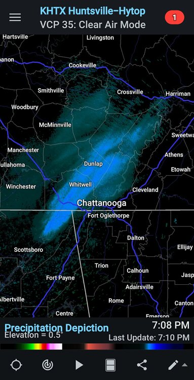
(cross-posted from obs thread) Note the feature over e TN, sw VA into w NC is a wave on arctic front, the upper level low is still back around n.e. Missouri and central IL dropping southeast. Moderate snow partly lake enhanced has broken out over n/c IL associated with the upper low. This light to moderate snow band will catch up to the pivoting arctic frontal wave tonight and Saturday morning as the low begins to deepen more rapidly off the coast. The 500 mb low has not quite closed off yet. 850 mb temps behind it are -24C (-12F) in Iowa. That slug of very cold air will be somewhere near TLH by this time Saturday (modified slightly). We will be seeing dynamics that may only be equalled by Feb 12-13 1899 in that region. -

February 2026 Medium/ Long Range Discussion: Buckle Up!
MillvilleWx replied to Weather Will's topic in Mid Atlantic
AIFS has done particularly well with verification on the lower end of QPF distribution (<= 0.25") and has a good indication of the coverage within those bounds. It still struggles with higher QPF allotments, especially anything with convective backgrounds. Might get the areal extent of the "where" right, but magnitude is going to struggle. This has been the case for the past few years of evaluations. Totally agree with the SLP and 5H outputs being the areas it does the best with. I have noticed it tends to waver outside the D5 window, which is the case with next weeks system as well, but it will slowly move and hold firm between the D3-5 window before usually settling within the bounds of a solution. Atmospheric complexities are still prevalent within the grand scheme and the AI models will still be subject to variability at leads due to the complex variables at hand. They are a useful tool and one that helps aid in medium and short range forecasting. -

Jan 30th-February 1st 2026 Arctic Blast/ULL Snow OBS Thread.
Jeff Co Vol replied to John1122's topic in Tennessee Valley
I think that it just has to be smaller than 1.95 MB. That's limiting, but it will work. -

1/30-1/31 Lake Effect Snow Threat - SE WI, NE IL, and NW IN
mimillman replied to A-L-E-K's topic in Lakes/Ohio Valley
Rippage
-

January 30th- Feb 1st ULL and coastal storm obs
HWY316wx replied to JoshM's topic in Southeastern States
Well, I hope this just fills in more and more.