All Activity
- Past hour
-

January 25/26 Jimbo Back Surgery Storm
NorthHillsWx replied to Jimbo!'s topic in Southeastern States
Idk, that has kinda been jumping around a bit on GFS depiction. To me that was more noise than a trend -

Central PA Winter 25/26 Discussion and Obs
paweather replied to MAG5035's topic in Upstate New York/Pennsylvania
18z GFS -
Yeah, bummer we don't have anything big to track here, but I'm just grateful we've finally turned the corner on the nearly unabated torch that the first half of winter brought. The next week has really trended colder from how it looked a few days ago. Now hopefully we'll get a little more snow to go with it.
-
 fold to euro ai, plus 30% more qpf and higher ratios than 10:1 say 14:1 to 16:1 and you have the exact solution for your backyard!
 -

January 24-26: Miracle or Mirage JV/Banter Thread!
Kmlwx replied to SnowenOutThere's topic in Mid Atlantic
Adding as well that we have to remember DC/Baltimore aren't traditionally "snow towns" - sure we go on runs but the trick is to set expectations in check. Enjoy the snow falling as much as you can - and you'll find that going from a 12 inch storm to a 6 inch storm doesn't hurt nearly as much. Life is just too short to hand wring when we just aren't a snow region. -

January 25/26 Jimbo Back Surgery Storm
Brick Tamland replied to Jimbo!'s topic in Southeastern States
The Wake County gradient looks legit. -

“Cory’s in LA! Let’s MECS!” Jan. 24-26 Disco
Chrisrotary12 replied to TheSnowman's topic in New England
agree -
People up north aren't going to like this run. Clearly gets routed/sheared East. Lots of backside action in NC. 12z had a similar situation but not as pronounced
-
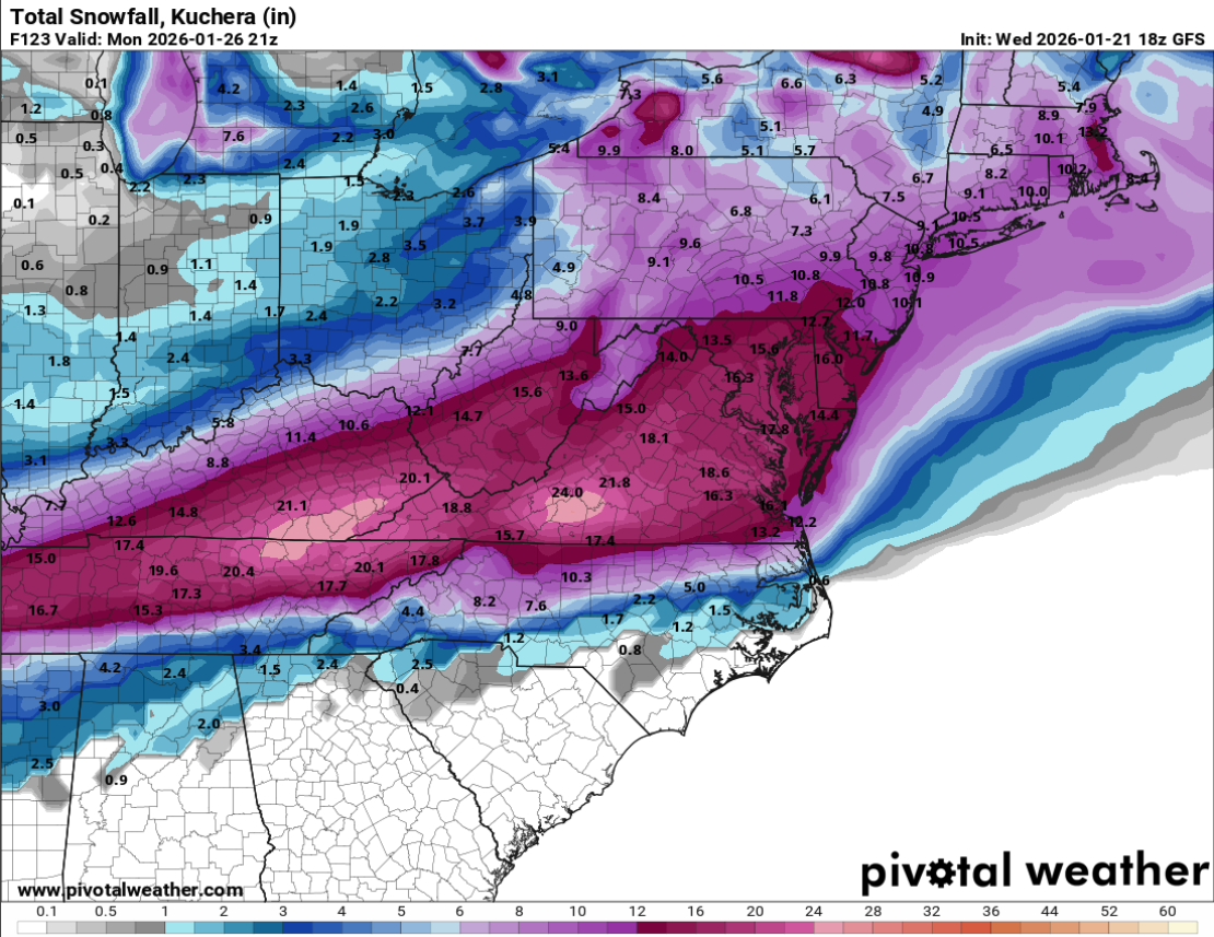
Per the 18Z GFS, we're still looking at a 35-40 hour storm across the board.
-

“Cory’s in LA! Let’s MECS!” Jan. 24-26 Disco
Damage In Tolland replied to TheSnowman's topic in New England
All modeling shows a nice wrap around/ backlash / hang back all day Monday into Monday night. That alone will add 2-4+ more in addition -
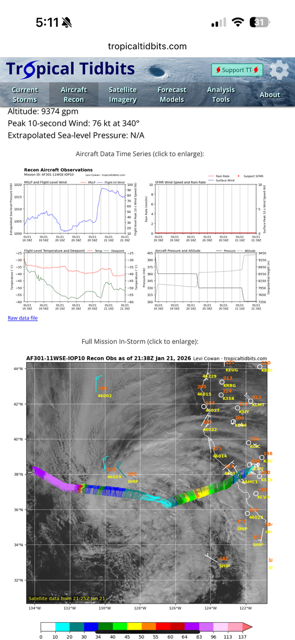
What's going to be really funny is if the data from the RECON just makes a bigger mess of things with the model outputs, at least initiially... Nothing would surprise me any more...
-

Possible Record Breaking Cold + Snow Sunday 1/25 - Tuesday 1/27
Jt17 replied to TriPol's topic in New York City Metro
I'd say a lot better... Looks like .3 more QPF than GFS . -
Guys, I'm tired. I'm not sure my heart can take much more of this hobby.
-

January 25/26 Jimbo Back Surgery Storm
Thrasher Fan replied to Jimbo!'s topic in Southeastern States

-

January 24-26: Miracle or Mirage JV/Banter Thread!
Scarlet Pimpernel replied to SnowenOutThere's topic in Mid Atlantic
ICON sux! Storm cancel! NEXT!!!! (Was that a good Ji imitation there?) -

Pittsburgh/Western PA WINTER ‘25/‘26
Mailman replied to Burghblizz's topic in Upstate New York/Pennsylvania
Honestly, I'd have been more concerned if it showed primary going up 79. -
Bam is having a hissy over it on X. Popped his , as he said, 30 second drawn map up and boasted about it. He has the ohoo River area being Snow bullseye. He may be right but I hope he's not.
-

Pittsburgh/Western PA WINTER ‘25/‘26
colonel717 replied to Burghblizz's topic in Upstate New York/Pennsylvania
It aligned with those fail of the eps that missed to the south. 4-5 inches for AGC -

Possible Record Breaking Cold + Snow Sunday 1/25 - Tuesday 1/27
psv88 replied to TriPol's topic in New York City Metro
agreed -
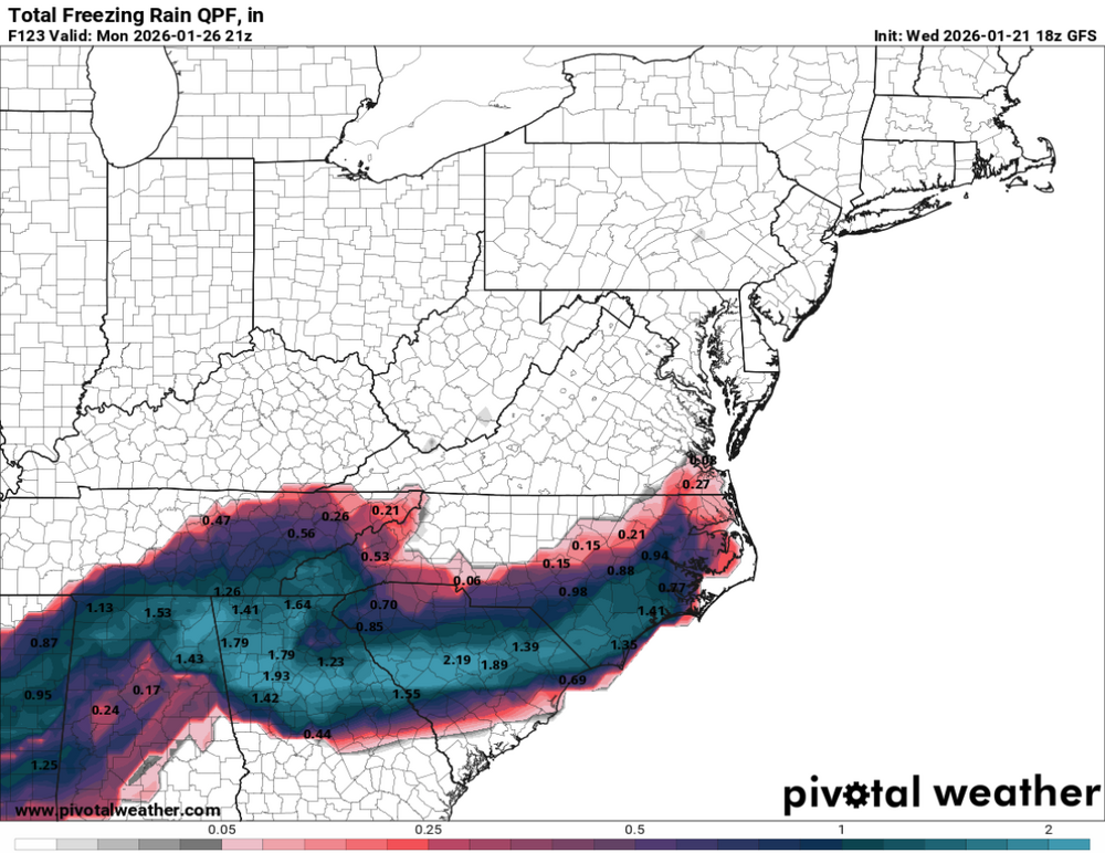
Wow that would be something else say 10in of snow, a quarter inch of zr and another 10inches on top for me. That middle layer would turn it all to a frozen cement within a day or two! That would be on the ground for weeks esp in the shade!
-
GFS is clearly an outlier in one way, but still looks closer to the European consensus than the icon. Still really hard to bet against the Eps and the euro AI when they are in close agreement like this. Blend those two and let it ride.
-
January 25/26 Jimbo Back Surgery Storm
Brick Tamland replied to Jimbo!'s topic in Southeastern States
-
They flying now so I’d think tonight.
-

Pittsburgh/Western PA WINTER ‘25/‘26
dj3 replied to Burghblizz's topic in Upstate New York/Pennsylvania
GFS back south, south is still my biggest concern if it’s a sloppy phase.