All Activity
- Past hour
-
Mostly tho really annoying summer cold...
-
Finally feels like summer.
-
Nice! I know our severe wx expert Jeff Halverson uses the site a lot -- he is always posting it in Slack. It does seem to be going well so far... kinda weird but should be fun.
-
I installed one yesterday and the other this morning.
-
what the
-
Yea our June’s have been so incredibly warm recently that our collective bias is +5
-

Junorch obs and discussion 2026
CT Valley Snowman replied to Damage In Tolland's topic in New England
91 and steamy. -
Mesoscale Discussion 1087 NWS Storm Prediction Center Norman OK 1127 AM CDT Thu Jun 11 2026 Areas affected...western Pennsylvania...eastern Ohio...western Maryland...north-central Virginia...and much of West Virginia Concerning...Severe potential...Watch possible Valid 111627Z - 111830Z Probability of Watch Issuance...60 percent SUMMARY...Increasing thunderstorm coverage is anticipated across the region through early afternoon. The main risk will be severe wind gusts, and perhaps some hail. A severe thunderstorm watch may be warranted to cover these threats. DISCUSSION...Amidst a relatively zonal (if not slightly ridged) upper-air pattern, a subtle impulse is noted in water vapor imagery over western Lake Erie and central OH as of 1600z. Associated mesoscale ascent is contributing to increasing mid-level cloudiness in the area. Closer to the surface, diurnal heating and warm, moist advection with southwesterly surface flow is driving temperatures and dewpoints into the low-/mid- 80s and 70s F, respectively. The 12z PIT (Pittsburgh, PA) sounding showed steeper lapse rates around 1-3 km AGL (up to around 7 C/km) that decrease with height, and bulk shear around 20-25 kts. Over the next couple of hours, this modest westerly shear should persist as the mid-level impulse moves through. Associated forcing and diurnal destabilization should yield scattered thunderstorm development through the early afternoon. Relatively large CAPE values (around 2000+ J/kg) will support some downbursts/severe wind gusts with any stronger cores or merging outflows. The moist environment and weaker-shear regime should temper the hail threat, but some hail cannot be ruled out. ..Flournoy/Gleason.. 06/11/2026 ...Please see www.spc.noaa.gov for graphic product... ATTN...WFO...BUF...CTP...LWX...RNK...PBZ...RLX...CLE..
-

-
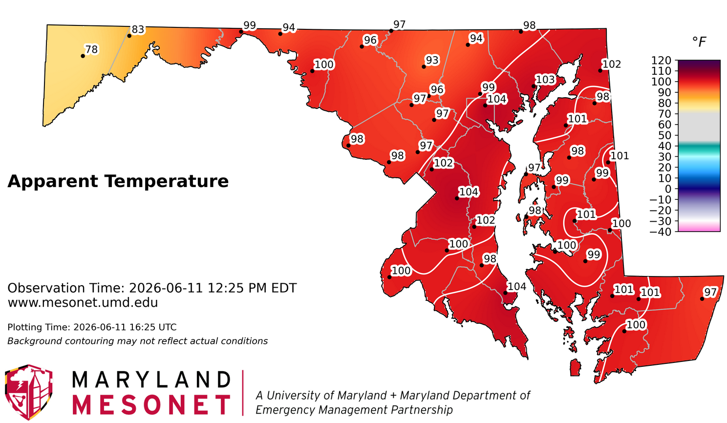
As of noon, RDU (and Rocky Mt, NC also) was at 94F, not surprisingly THE hottest in the entire SE. I’m including all SE states including FL. With 94 at noon, RDU has a a good shot at ~101-2 despite the NWS forecast having “only” upper 90s for the Raleigh area. This, of course, is assuming that clouds and convection don’t start to increase there or even in the general vicinity: “TODAY MOSTLY SUNNY. ISOLATED SHOWERS AND THUNDERSTORMS THIS AFTERNOON. HOT WITH HIGHS IN THE UPPER 90S. SOUTHWEST WINDS 5 TO 10 MPH. CHANCE OF RAIN 20 PERCENT. HEAT INDEX VALUES UP TO 102.”
-
Logan is referenced all the time. Have an intern look up the coops and they’ll see it’s off by 2-3” total LEQ for the late Jan and late Feb snow events. But the media just blindly runs with it.
-
Man that is one clean looking radar at the moment.
-
There's not a single 12z CAM that has a handle on evolution of the initial MCS.
-
Scott is right about piss poor w.e. measurements in some of the big snow events. Slap on a few inches there. The last 20+ years have been really wet overall too and that has caused a bump up in the 30 years normals. Throw in a slightly dry stretch and the same period looks a lot drier now than it would’ve in the 90s. I’m not saying it hasn’t been BN in some areas long term, but I think lake and stream levels are better indicators. And don’t get me started again about 1” lawns.
-
97 at 12:30, how high will we go today?
-
Truth
-
Stream flow is low, but severe makes it sound like everything is drying up.
-
The problem is their methodology. If we have lower precip winter, they count as a negative. But in winter, all the precip it’s either going into the ground or to the lake and rivers, etc. Nothing is absorbing it. So it makes it look like we are El Paso but it’s just kind of silly if you asked me. It’s definitely been dry but extreme is kind of ridiculous. We actually had decent rain last summer too.
-
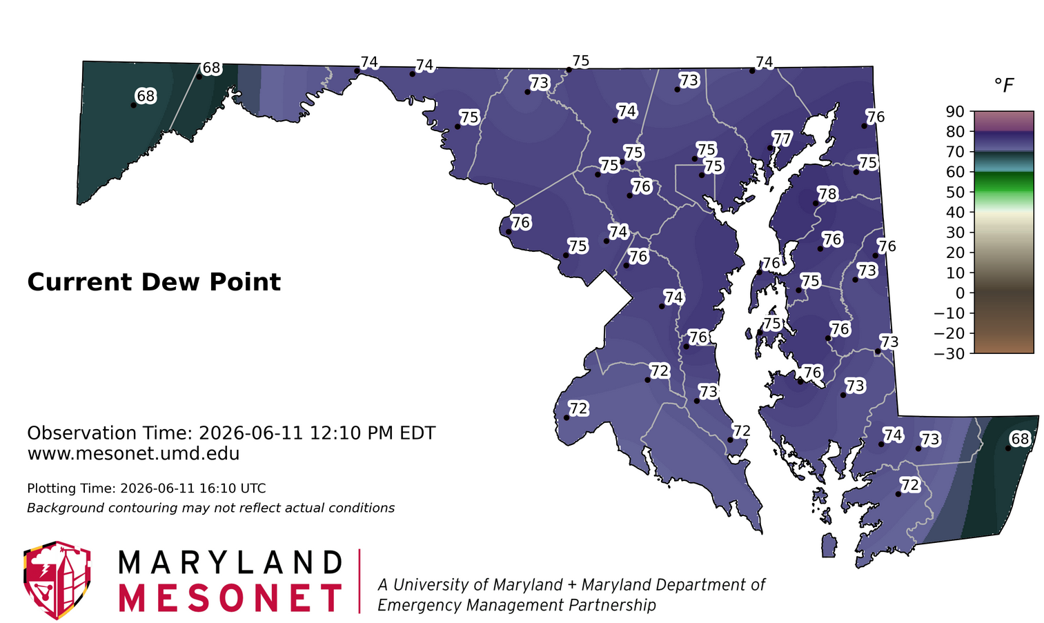
92/74/101. Mid summer feel
-

2026 Mid-Atlantic Severe Storm General Discussion
Eskimo Joe replied to Kmlwx's topic in Mid Atlantic
LI's of -9, solid low level lapse rates, and healthy CAPE. If only we had 30-40 kts of shear, we'd be cooking. -
GRR AFD: The question is does the convection survive all morning and push across Lake Michigan during the mid afternoon hours. We will follow the HREF for guidance on this. The HREF weakens the initial convection as it moves towards or out over Lake Michigan this afternoon. This will allow the main surge to move in this evening out ahead of the main upper wave. If the first round of convection survives and spreads into Lower Michigan this afternoon that could modulate our event for the evening. We do not think that is going to happen.
-

2026-2027 Super El Nino
snowman19 replied to Stormchaserchuck1's topic in Weather Forecasting and Discussion
There is about to be a massive warming surge…. @bluewave @donsutherland1 @LakePaste25 @csnavywx @forkyfork -
94/73/103 right now. Days like today make me regret having a career working outside