All Activity
- Past hour
-
Euro?
-
Havent even had a chance to go this year. Is that the Toe?
-
Two years ago we were hit by a direct strike and it caused $70k of damage to our house. It is incredible how the perspective changes once that has happened. .
-
A little wind in Pikesville, Power flickered a few times. Nothing crazy
-
Drove to my brother's in Mass today it was 57, back home in Maine its 37.
-
.thumb.jpg.6a4895b2a43f87359e4e7d04a6fa0d14.jpg)
Central PA Spring 2026 Discussion/Obs Thread
Yardstickgozinya replied to Voyager's topic in Upstate New York/Pennsylvania
Really amazing picture regardless. That's not to far from me. I wish I could have been that close. -
Models are not showing anything in the mid to long range but I also think we get 1 more snow event .
-
Coating tomorrow on cold surfaces
-

2026 Mid-Atlantic Severe Storm General Discussion
MN Transplant replied to Kmlwx's topic in Mid Atlantic
Ah connective season. That means a trace of rain and thunder somewhere in the distance. -
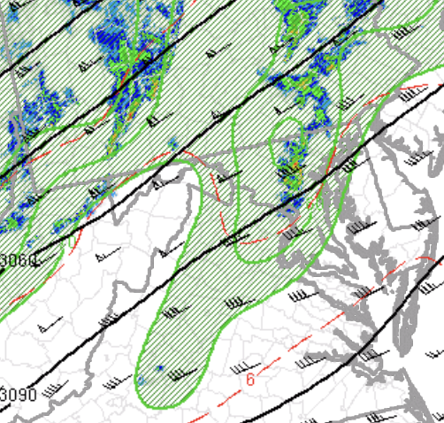
This event is very driven by 700mb forcing. Local maxima NW of Baltimore, where the most severe storming is, and much less flow with southern extent, which is causing the southern side of the storm to be much weaker. Our temp/dew spreads are a little wider down here as well, which is not helping matters.
-

Central PA Spring 2026 Discussion/Obs Thread
canderson replied to Voyager's topic in Upstate New York/Pennsylvania
581 W after the split - she was running an errand instead of driving straight home -
Nice gusty shower in progress. My wife saw a lightning strike in the distance as it approached, but no T&L that I can hear or see with the rain.
-
58/55 now after a semi-chilly day in the mid 40s.
-
Feels a bit overaggressive to warn such broad, weak rotation.
- 119 replies
-
- 1
-

-
- severe
- thunderstorms
- (and 7 more)
-

E PA/NJ/DE Spring 2026 Obs/Discussion
CoolHandMike replied to PhiEaglesfan712's topic in Philadelphia Region
Pouring now. Looked iffy before but now it's just looking like a gully-washer. -

Central PA Spring 2026 Discussion/Obs Thread
717WeatherLover replied to Voyager's topic in Upstate New York/Pennsylvania
-

Central PA Spring 2026 Discussion/Obs Thread
Voyager replied to Voyager's topic in Upstate New York/Pennsylvania
Storms really fell apart till they got here. My station reported only one nearby lightning strike. -
At 18Z it's no longer just the GFS showing snow tomorrow, as the AIFS and NAM have a bit and the HRRR is bullish (although it's the long range HRRR which usually is crappy). However, these snowmaps are at 10:1 ratios, which are not going to happen. I'll just be happy to see falling snow, even if it doesn't accumulate with temps in the mid-30s - maybe a bit on grassy surfaces at most, unless temps go a bit lower than forecast. The 12Z Euro also showed an inch or so of snow in the late afternoon - will be interesting to see what the 18Z runs say for those two models. The NWS remains unimpressed (can't blame them), mentioning a change to snow showers, but not predicting any accumulation worth noting (<1/2" for areas at elevation in NWNJ/NEPA/Hudson Valley).
-
Central PA Spring 2026 Discussion/Obs Thread
Voyager replied to Voyager's topic in Upstate New York/Pennsylvania
Looks like a Pacific Pride sign. They're a cardlock diesel provider, and yes, that's in the Camp Hill/Lemoyne area. -

2026 Mid-Atlantic Severe Storm General Discussion
Maestrobjwa replied to Kmlwx's topic in Mid Atlantic
Tornado warning even here in the city- 119 replies
-
- 2
-

-
- severe
- thunderstorms
- (and 7 more)
-

2025-2026 Fall/Winter Mountain Thread
Buckethead replied to Buckethead's topic in Southeastern States
I snuck some fishing in this afternoon. The smallies are hot! Sent from my Pixel 10 Pro using Tapatalk -
Central PA Spring 2026 Discussion/Obs Thread
Yardstickgozinya replied to Voyager's topic in Upstate New York/Pennsylvania
Actually, the area I am talking about is in lemoyne not Camphill. -
great, thanks. I'm curious about that because like every PNS has East Granby as an ob, which after those missing years you rarely see.
-
Just got back from a run. Perfectly timed so I got inside just before the first drop.
-
SVWX is definitely my "specialty" though. What got me into weather, and what is still my favorite to forecast. To be fair I was probably right about the DC area, we just don't have enough instability because we had a local area of persistent cloud deck for basically the entire day.
- 119 replies
-
- 1
-
-
- severe
- thunderstorms
- (and 7 more)