All Activity
- Past hour
-
Part snark, part reality ... ...but it's mostly driven by addiction to dystopian triggered dopa in what's become a blue light over stimulated, recreationally enraged society. If there's no actual Paleocene-Eocene Thermal Maximum reduxing heat wave, or cannon ball-sized hail clouds suspending finger of god's carving canyons through the hearts of urban centers ... then watch out! Drought becomes fanatical and 'quite real'. Sometimes this engagement is just not subjectively exciting enough.
-
Thankfully it was 50 average S of the NH down here. Looks like summer's finally gotten to your doorstop. Needs another little push to finally get N of you LOL
-
Later this week, and next week appears to get more active as the general pattern begins to change. Increasing chances of storms every couple days once we get to this Wednesday.
-
Took a quick look at some of the damage on the way into work and over the span of 1.5 miles some of the trees were blown down in different directions. Might have been a weak downburst, which Upton mentioned the possibility of in a few of their dicussions.
-
66 at the moment by it's just 9am. Maybe 79 or 80 /52 under 100% purified blue.. Hell, even the pollen's at least temporarily alleviated. 1/2" rain btw from that weird late blob that slid down eastern zones last evening. Rained harder than sat cloud tops suggested it should, too. Interesting. Lawn looks visibly appreciative for whatever the cause.
-
June 8 1972: 8 inches of rain falls in 7 hours at Madelia Township in Wantonwan County. 1893: Violent winds occur at Maple Plain from 1:30 to 2:15pm. A large frame house was moved 8 feet from its foundation. Many barns and hay sheds blown over by the wind. One barn was blown across Dutch Lake. For Monday, June 8, 2026 1953 - The worst tornado of record for the state of Michigan killed 116 persons. Flint MI was hardest hit. The tornado, half a mile in width, destroyed 200 homes on Coldwater Road killing entire families. (The Weather Channel) 1966 - A tornado ripped right through the heart of the capitol city of Topeka KS killing sixteen persons and causing 100 million dollars damage. The tornado, which struck during the evening, cut a swath of near total destruction eight miles long and four blocks wide. It was the most destructive tornado of record up until that time. (David Ludlum) 1974 - Severe thunderstorms spawned at least twenty-three tornadoes in Oklahoma during the afternoon and evening hours. One of the tornadoes struck the town Drumright killing sixteen persons and injuring 150 others. A tornado struck the National Weather Service office in Oklahoma City, and two tornadoes hit the city of Tulsa. Thunderstorms in Tulsa also produced as much as ten inches of rain. Total damage from the storms was around thirty million dollars. It was the worst natural disaster of record for Tulsa. (Storm Data) 1987 - Thunderstorms in the northeastern U.S. produced large hail and damaging winds in Vermont injuring two persons. Thunderstorms in Ohio produced wind gusts to 75 mph near Akron, and deluged Pittsfield with two inches of rain in thirty minutes. (The National Weather Summary) (Storm Data) 1988 - Overnight thunderstorms in Iowa produced 5.20 inches of rain at Coon Rapids. Thunderstorms in the Florida Keys drenched Tavernier with 7.16 inches of rain in 24 hours. Eleven cities in the central U.S. reported record high temperatures for the date. (The National Weather Summary) 1989 - Thunderstorms produced severe weather over the Central Gulf Coast Region during the day and evening. Severe thunderstorms spawned 17 tornadoes, including one which injured ten persons and caused a million dollars damage at Orange Beach, AL. Thunderstorm winds gusting to 90 mph killed three persons and injured four others at Mobile AL. Thunderstorms also deluged Walnut Hill and Avalon Beach, FL, with eight inches of rain. (Storm Data) (The National Weather Summary)
-
Rain this morning. Welcome sight.
-
We've already seen some contenders this spring and early summer, so in fairness this is speculation pending final judgement... Today is the top 1 day Intangible in support is the fact that it's happening perfectly in mockery of the weekend now being over. So, being collectively imprisoned by thankless jobs and not really available to actually be a part of it? definitely adds to the mystique of this day achieving numero uno status
-
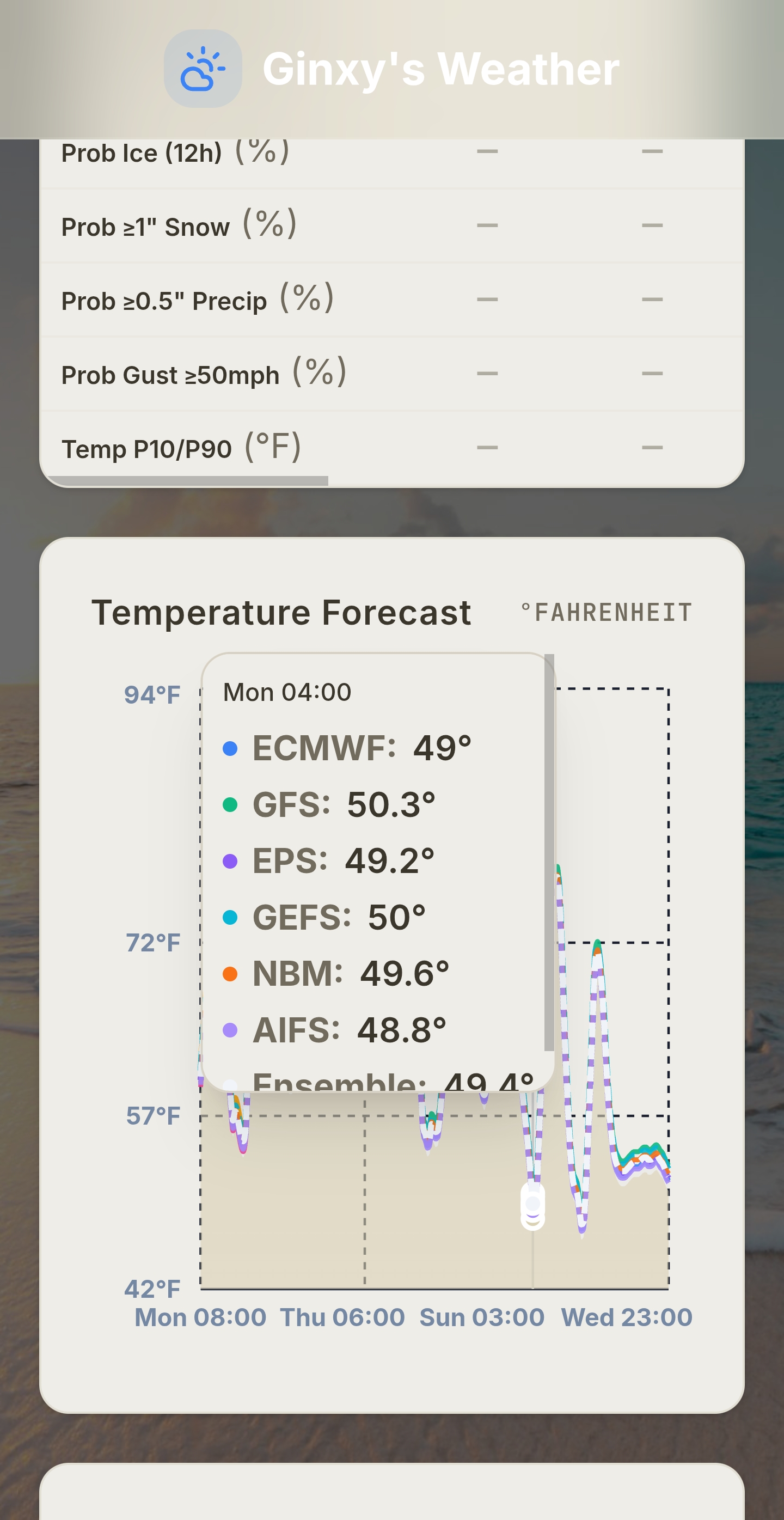
Forecast is for 49 tonight.. this week will be hot but I doubt we hit 90 here.. 7 to 10 days of heat then back to average for a bit
-

2026-2027 Super El Nino
olafminesaw replied to Stormchaserchuck1's topic in Weather Forecasting and Discussion
- Today
-
Nice morning here-breezy and AC gets a break 65
-
CIPS is also fairly supportive of some sort of threat at the end of the week. CIPS extended range remains supportive for severe as well way out into the long range.
- 434 replies
-
- 1
-

-
- severe
- thunderstorms
- (and 7 more)
-

2026-2027 Super El Nino
GaWx replied to Stormchaserchuck1's topic in Weather Forecasting and Discussion
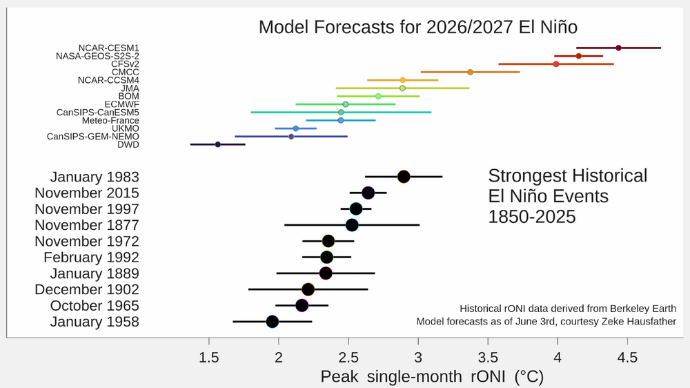
Nino 3.4 warmed only 0.2 in today’s release for last week averaged out vs the prior week from 0.5 to 0.7 vs my guess based on daily OISST levels/changes of it warming 0.3 (from 0.5 to 0.8). But this difference could possibly be mainly due to rounding. For example, perhaps the prior week was, say, +0.46 vs last week being, say, +0.74 or whatever. It has gotten more E based the last 5 weeks but (as per what I recently posted) the Euro doesn’t have it getting more E based overall from this point forward and thus keeps it from getting anywhere near as E based as 1997-8: 1+2 3 3.4 4 29APR2026 0.6 0.4 0.4 0.5 06MAY2026 1.0 0.5 0.4 0.5 13MAY2026 1.3 0.6 0.4 0.6 20MAY2026 1.6 0.7 0.5 0.6 27MAY2026 1.7 0.8 0.5 0.7 03JUN2026 2.1 1.0 0.7 0.7 -
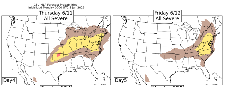
CSU MLP likes both Thursday and Friday
- 434 replies
-
- 2
-
-
- severe
- thunderstorms
- (and 7 more)
-
We didn’t have anything like that but it peaked about 3:00 at my house too. Sat between 95-96 from 1-4 with the 97 peak. Miserable
-
10 out of 10 so far this month! I wish it could be like this till October.
-
Then there is next Monday Tuesday on models. Nice summer stretch enroute first. For Hubbardston Ma
-
Not to be 'that' conspiracist person, but the more the sports betting has increased, the more those types of calls are seeming to happen.
-
Nice start today with a breeze and 72. Looking forward to low/mid 80s for a couple of days before the big heat is back. Looking at possibly 100 on Thursday
-
Anyone ever winder why it seems some areas get more thunderstorms then others? For my immediate area it's Glen Burnie that is the Hotspot for storms. I feel like from Ellicott City down to Glen Burnie is thunderstorm ally. My area was on a hot hand last July. Every chance for storms seemed to deliver. Some years I can't buy a storm. They all hit Glen Burnie.
-
Friday maybe? From Day 4-8 SPC OTLK ..Day 5/Friday... A number of the 00z models progress a lower-latitude short-wave trough through the upper OH Valley and lower Great Lakes, which is a departure from previous model runs. That scenario would increase severe-weather potential across those areas into New England, and perhaps the Mid-Atlantic, given the potential for a moderately unstable air mass across the pre-frontal warm sector. Should subsequent model runs remain consistent with this recent trend, an unconditional 15% probability contour may be needed in the next forecast update. Elsewhere, Isolated severe storms appear possible across portions of the southern High Plains.
-
Thanks. I realize that the RDU sensor is often a hot spot under sunshine in the warm season per past discussions I’ve read here and elsewhere. Do you know if your house had temps that jumped around ~6 F within just a few minutes of 3 PM? That seems very high with little change in sky condition (mostly sunny as opposed to large amounts of cloud cover suddenly moving in or out) and no big wind direction shift!
-
33° at Estcourt Station. Some mid 30s in N NH and W ME too.
-
Replaced my rain gauge yesterday. Right on cue.
-
48 at the house this morning. That’s it for a while