All Activity
- Past hour
-
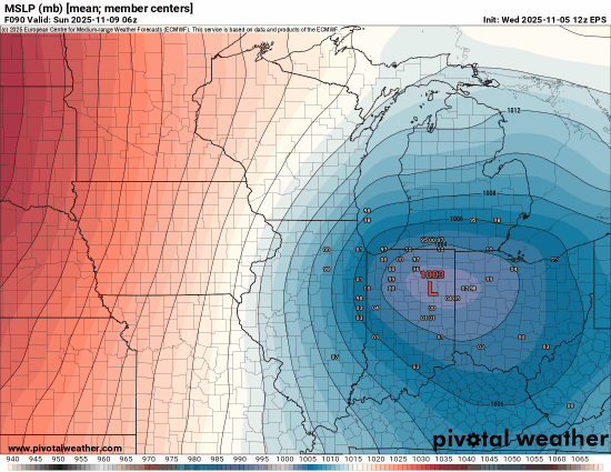
Not sure why the gif is reversed, but I like the trend on the eps honing in on a deeper low, located right near the MI/OH/IN border, which would be pretty favorable for snow for us in michigan.
-
 Was a High Wind Warning ever issued?
 -

November 2025 general discussions and probable topic derailings ...
SJonesWX replied to Typhoon Tip's topic in New England
as usual I have no idea what you are talking about. 51 and cloudy here, sun has not been out all day aside from around 7am. -
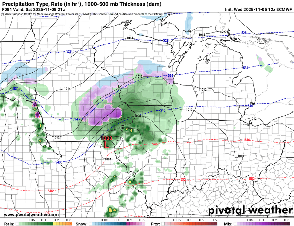
12Z wasn’t a good suite if you wanted token flakes east of the mountains. The energy just doesn’t dig enough to be a factor other than providing the enhancement needed for a nice NW flow event. Other than that, how about the Euro showing sea effect snowfall off the OBX in November? .
-
Records: Highs: EWR: 79 (2022) NYC: 78 (1961) LGA: 75 (2022) JFK: 75 (1975) Lows: EWR: 27 (1933) NYC: 23 (1879) LGA: 32 (1951) JFK: 32 (1965) Historical: 1894 - The famous Election Day snowstorm occurred in Connecticut. As much as a foot of wet snow fell, and the snow and high winds caused great damage to wires and trees. Winds gusted to 60 mph at Block Island RI. (David Ludlum) 1894: A significant snowstorm impacted New England on November 5th through 6th. It formed off the New Jersey coast on the 5th and passed east of Connecticut with rapidly increasing heavy rain, snow, and high winds. The heavy snow and high winds caused significant damage to trees and brought down telegraph poles by the hundreds. As a result, all southern New England's telegraph and telephone services were crippled, and fallen poles and trees delayed railroad trains. 1961 - Strong Santa Ana winds fanned the flames of the Bel Air and Brentwood fires in southern California destroying many homes. At 10 PM the Los Angeles Civic Center reported a temperature of 74 degrees along with a dew point of 5 degrees. On the 6th, Burbank reported a relative humidity of three percent. (The Weather Channel) 1977 - A slow moving storm produced five to nine inch rains across northern Georgia causing the Toccoa Dam to burst. As the earthen dam collapsed the waters rushed through the Toccoa Falls Bible College killing three persons in the dorms. Thirty-eight persons perished at a trailer park along the stream. (David Ludlum) 1987 - Low pressure off the California coast produced stormy weather in the southwestern U.S. Flash flooding stranded 8000 persons in the Death Valley National Park of southern California. Thunder- storms over southern Nevada produced dime size hail and wind gusts to 68 mph around Las Vegas. Unseasonably mild weather in the northeastern U.S. was replaced with snow and gale force winds. (The National Weather Summary) (Storm Data) 1988 - A powerful low pressure system produced high winds from the Great Plains to New England, and produced heavy snow in northern Wisconsin and Upper Michigan. Winds gusted to 64 mph at Knoxville TN, and reached 80 mph at Pleasant Valley VT. (Storm Data) (The National Weather Summary) 1988: An F1 tornado touched down south of Altoona near Hollidaysburg. Several homes were damaged with roofs torn off and broken windows, numerous trees were toppled, and garages and other outbuildings were destroyed. 1989 - Temperatures warmed into the 80s across much of Texas. Highs of 86 degrees at Abilene, Fort Worth and San Angelo were records for the date. (The National Weather Summary) 2002 - Severe thunderstorms moved across southeastern Alabama and the Florida panhandle, producing wind damage and several tornadoes. A tornado struck the Alabama town of Abbeville killing 2 people and injuring 25 (Associated Press). 2017: A classic Tornado Debris Signature (TBS) was observed in Washington County, Indiana.
-

Best Mid-Atlantic winter storm of the last 50 years
WEATHER53 replied to PrinceFrederickWx's topic in Mid Atlantic
Without a doubt Snowmaggedon Most impressive March 1993 Superstorm -
Strat warm talk... https://www.severe-weather.eu/global-weather/early-stratospheric-warming-event-polar-vortex-forecast-winter-2025-2026-united-states-canada-europe-fa/
-
66 / 22 here. Winds will pick up soon.
-
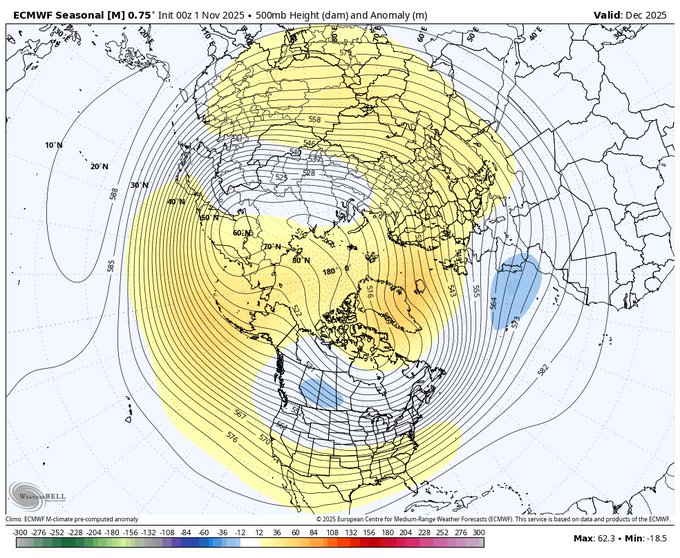
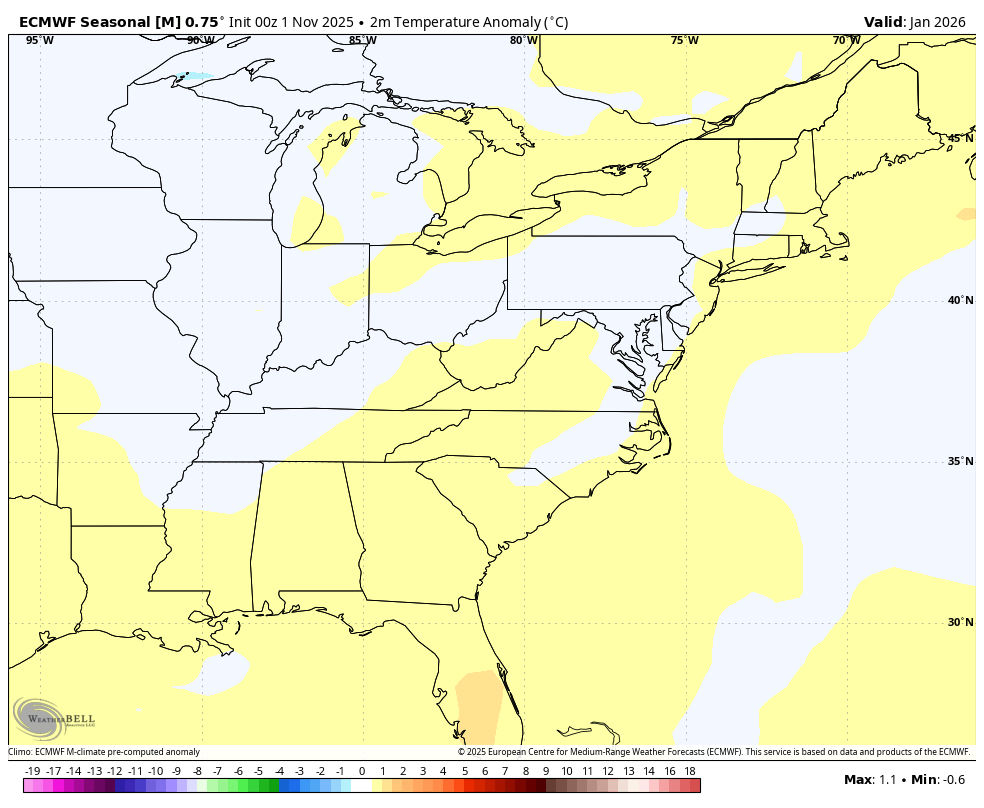
WB latest EPS seasonal. Biggest, and significant cool down forecast compared to last month's run is January.


-
Some models had already been teasing some snow mixing in across Iowa. Now the Euro has finally joined them.
-
-

Overnight Wednesday, November 5, 2025 Wind Event
Ginx snewx replied to weatherwiz's topic in New England
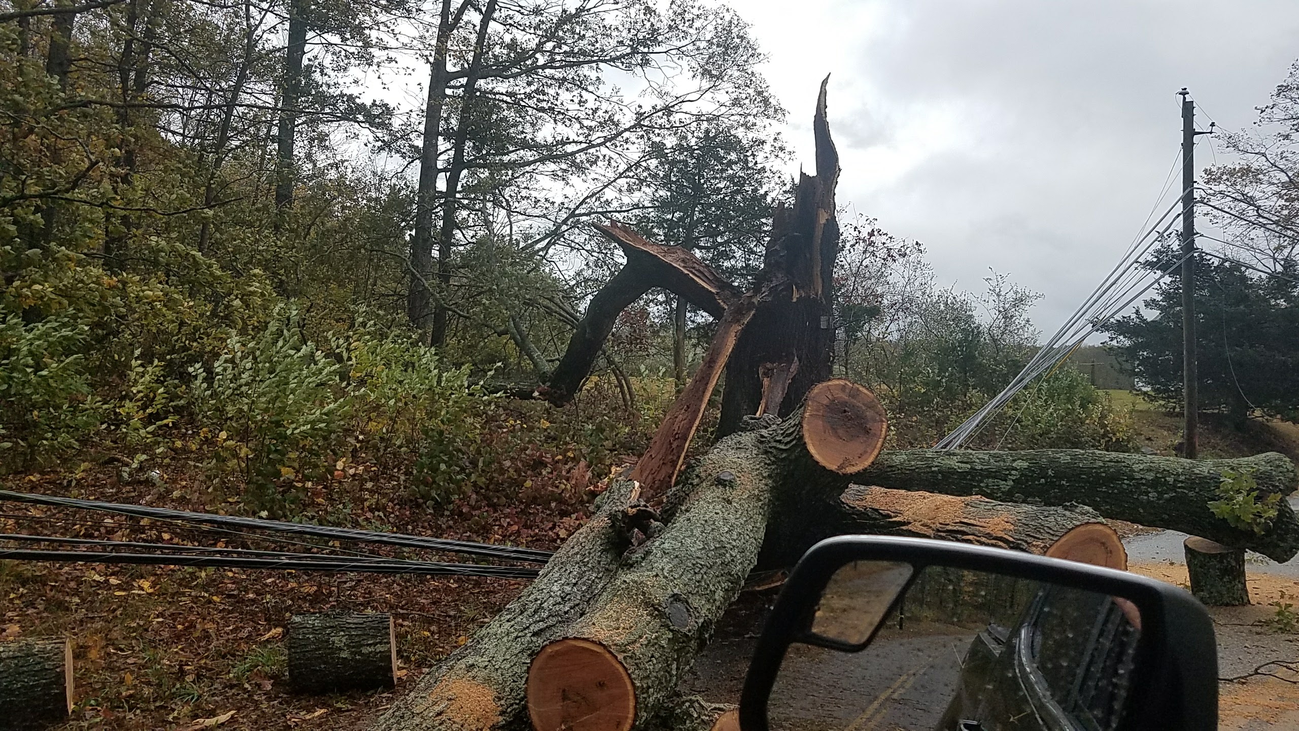
Oct 17 is my non tropical Benchmark. Pretty scary long duration with limb bark shingles banging agint the house for hours . Had a 4 inch limb go thru the roof. Lost all the ridge vent shingles. Insurance guy told me hadto be 70 plus to do that.thumb.jpg.0526e338b771028ea777e884465fdddb.jpg)

-
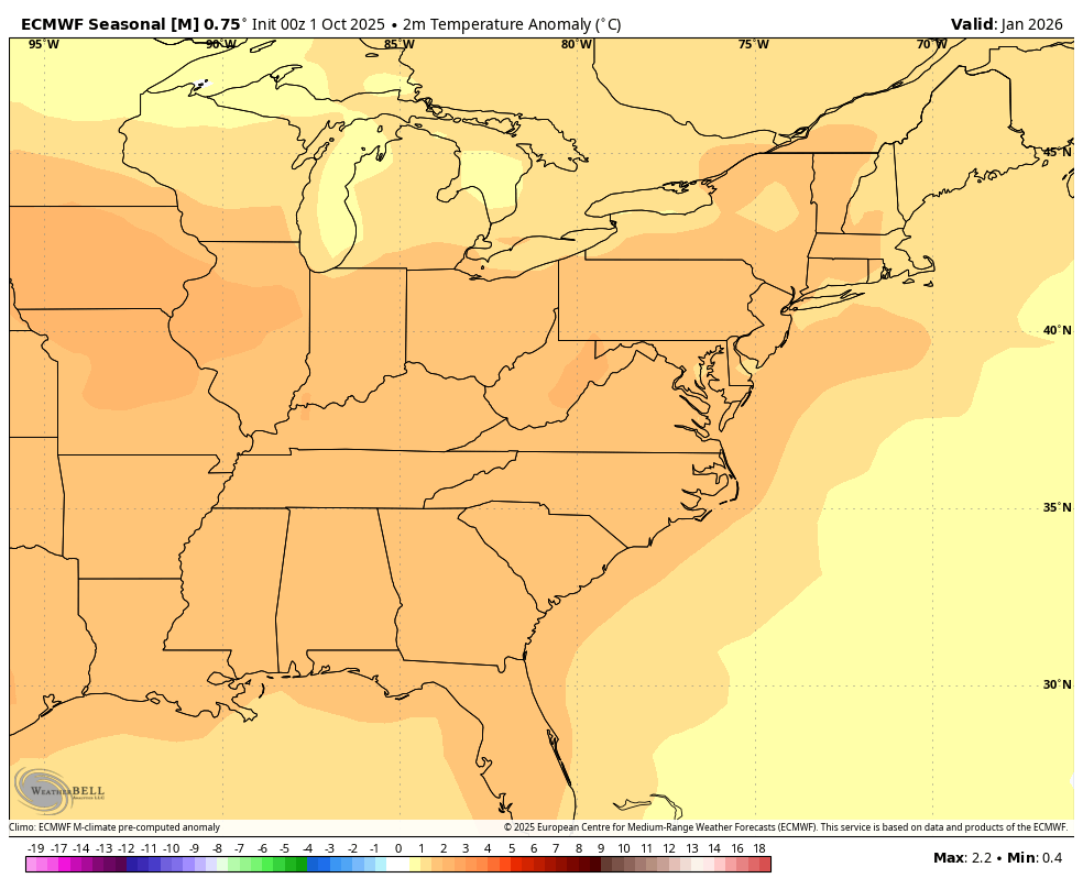
Euro seasonal for December from MA forum.
-
 Downgraded to wind advisory
 -

Overnight Wednesday, November 5, 2025 Wind Event
Hailstoned replied to weatherwiz's topic in New England
I recall that here in MA-- plus skating on the Concord River-- solidly frozen but for an open channel in the fast current middle. How often does that happen these days? Needless to say, we skated the peripheries. That combination of extreme wind and cold was both long lasting and memorable. -
Unless the niña breaks in February.
-
I drove up to about 3000' on the Cherohala Skyway on summer tires in my GTI during that 2014 snow. I still have a bunch of pictures of it somewhere. I couldn't comfortably drive any further towards the NC line, but I think there was 3-4" on the ground at that elevation and it was still coming down. Super windy and cold too.
-

November 2025 general discussions and probable topic derailings ...
jbenedet replied to Typhoon Tip's topic in New England
Beautiful fall day anywhere in SNE where sun is sustaining 60 in view -
@WxUSAF would like this: Ridging in Alaska Ridging in Greenland NW flow all the way back to the North Pole Stressed polar vortex
-
It's balmy and around 60 at 10:30 AM this November day. There are hints of a more exciting pattern change in 7-10 days (isn't there always?) but nothing but warm and dry in the short term. Bring on... something!
-
November 2025 general discussions and probable topic derailings ...
jbenedet replied to Typhoon Tip's topic in New England
Get off your computer and go outside -

Mountain West Discussion
mayjawintastawm replied to mayjawintastawm's topic in Central/Western States
I realize we are technically well within "cold season", so I'll start a new thread, even though my lawn is still green and growing a bit. Here's to more exciting weather the next few months! -

Overnight Wednesday, November 5, 2025 Wind Event
CT Valley Snowman replied to weatherwiz's topic in New England
Looks like BOX went with an advisory for most with a warning for the east slopes of the berks and the cape. -

Central PA Fall Discussions and Obs
canderson replied to ChescoWx's topic in Upstate New York/Pennsylvania
I like how CTP called me out specifically Most peak wind gusts will be in the 45 to 50 mph range, but given the several hour period of westerly 850 mb winds increasing to 55 to 65 kts in the 22Z Wed to 05Z Thu period, there could be some sfc gusts AOA 60 mph on the ridges, within and just to the east of gaps in the ridges and accompanying the stronger showers in that period. -
 Wouldn’t be surprising if there’s snow showers or light snows in SNE later Monday into early Tuesday .. with dusting - 1”
.thumb.jpg.ad3a2e31d30aff035044689b311a0540.jpg)


.jpg.3ac17efcac2680fb69bf9bc70bf32fc7.jpg)