All Activity
- Past hour
-
 cost of cheap propecia now [url=http://hairguardrx.shop/#]HairGuardRx[/url] or buying generic propecia price
 -
I’ve worked in management for some rich guys before. If one of them had said publicly that he had provided me with all the resources I had asked for, was embarrassed by the results, and considered the performance of the organization to be a threat to his legacy, I wouldn’t expect to keep my job. Elias is a smart cookie. Pretty sure he could read the writing on the wall when Rubenstein made those comments early last month.
-

Septorcher 2026 Discussion - Endless Summer
HIPPYVALLEY replied to Damage In Tolland's topic in New England
Invasive and hostile to stone fruit trees. Squash them. -
They all depict basically the same thing. Hard to parse details with these seasonal products and much of it is up for interpretation. On the new Euro Feb looks a bit more like the CFS at h5 with stronger +heights from Hudson Bay and extending eastward. Is that the result of Pac puke across Canada? Some might say its an impressive NAO block, but its a bit too far south and the height line contours are bending the wrong way.
-
Combine the euro cfs and cansips and we probably good lol
-
PA is in currently 2nd place for the most tornadoes behind 1998.
-
-
if a super nino can't give us a cool summer then nothing can
-
(002).thumb.png.6e3d9d46bca5fe41aab7a74871dd8af8.png)
Central PA Summer 2026 Discussion/Obs Thread
ChescoWx replied to Voyager's topic in Upstate New York/Pennsylvania
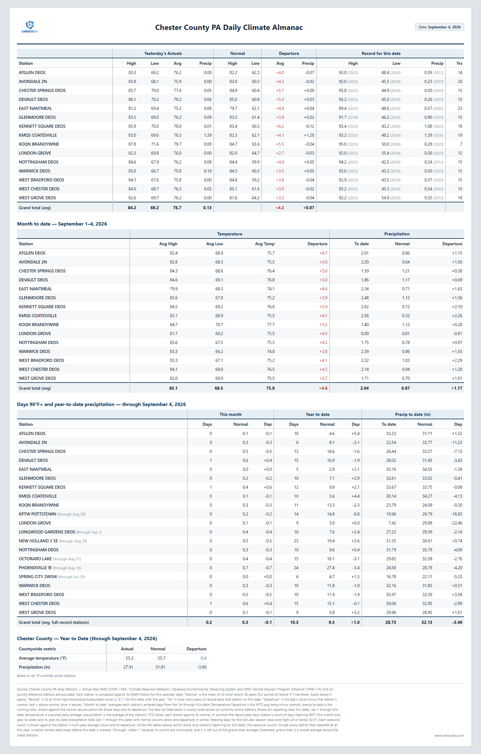
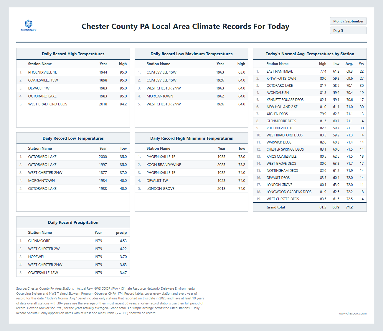
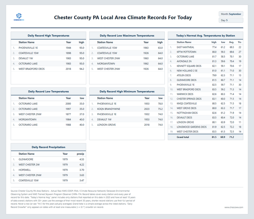
A beautiful weather weekend on tap across the area lasting into the new week. Temperatures will be near normal today before falling to below normal levels tomorrow through Labor Day. We warm to a couple of degrees above normal by mid-week before we turn cooler again by the end of the new work week. We look pretty dry through the week.
-
E PA/NJ/DE Summer 2026 Obs/Discussion
ChescoWx replied to PhiEaglesfan712's topic in Philadelphia Region
A beautiful weather weekend on tap across the area lasting into the new week. Temperatures will be near normal today before falling to below normal levels tomorrow through Labor Day. We warm to a couple of degrees above normal by mid-week before we turn cooler again by the end of the new work week. We look pretty dry through the week.
-
E PA/NJ/DE Summer 2026 Obs/Discussion
ChescoWx replied to PhiEaglesfan712's topic in Philadelphia Region
Honestly I would not expect the Point and Click from our great team at the NWS Mt. Holly to get down to this level of a "backyard" forecast. My forecast uses calculated biases from historical model runs against the actual data from my station over the last 23 years. They have a lot bigger backyard to worry about than EN!!!! -
buy propecia without a prescription: propecia buy : buying propecia pill
-

super el nino banter thread
forkyfork replied to forkyfork's topic in Weather Forecasting and Discussion
if this verifies it's lights out for winter in the east. haha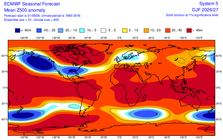
-

Septorcher 2026 Discussion - Endless Summer
Lava Rock replied to Damage In Tolland's topic in New England
So much for prtly sunny. Clouds, cool, breezy. Can't get rain when its supposed to rn and can't get sun either. Piss off Sent from my SM-S921U using Tapatalk -
thank you!
-
Dew point is down. Feels better out there, but not as sunny as I thought it be. Current conditions at Wilmington Airport (KILG) Lat: 39.67°NLon: 75.61°WElev: 72ft. Overcast 73°F 23°C Humidity 71% Wind Speed N 8 mph Barometer 29.88 in (1011.6 mb) Dewpoint 63°F (17°C) Visibility 10.00 mi Last update 5 Sep 8:51 am EDT
-
I could but not going to bother lol. I am sure he will post 10 maps. Its very similar to last month but yes each winter month is a bit milder than the last run for the MA and NE. Milder across the south too. Nothing remarkably different at h5.
-
Records: Highs: EWR: 95 (2023) NYC: 94 (1985) LGA: 93 (1985) JFK: 94 (1961) Lows: EWR: 53 (2000) NYC: 51 (1963) LGA: 54 (2000) JFK: 52 (1989) Historical: 1925 - The temperature at Centerville, AL, soars to 112 degrees to establish a state record. Every reporting station in Alabama was 100 degrees or above that afternoon. (The Weather Channel) 1929: Early season snowfall occurred in the mountains of Wyoming and the Black Hills of South Dakota on September 5th and 6th. The highest snowfall amount was 16 inches in Fox Park, Wyoming. 1933 - A hurricane hit Brownsville, TX, killing forty persons and causing 12 million dollars damage. (David Ludlum) 1933: A Category 3 hurricane made landfall on South Padre Island, Texas during the late evening hours on September 4th, or Labor Day. The storm caused 40 fatalities and nearly $17 million in damages. With the storm making landfall during a holiday weekend, fatalities could have been much higher. The following is from the report of the official in charge at Corpus Christi, Texas: "Probably never before in the history of Texas hurricanes have such widespread and early warnings been given as were received from Washington in advance of this one. The telegram of Saturday, September 2, warning all persons to avoid inaccessible places over the weekend probably saved thousands of lives." 1950 - Hurricane Easy produced the greatest 24 hour rainfall in U.S. weather records. The hurricane deluged Yankeetown, on the upper west coast of Florida, with 38.7 inches of rain. (David Ludlum) 1950: Hurricane Easy was an erratic and unpredictable hurricane that lingered over the Tampa Bay area for days, dropping torrential rains and causing damage especially in Cedar Key, Florida where the storm eventually made landfall. This hurricane dumped 38.7 inches of rain in 24 hours in Yankeetown, a record for the U.S. at the time, and caused $3.3 million in damage. Total rainfall amounts in Yankeetown was 45.20 inches. 1975 - Strong winds reduced visibilities to near zero in blowing dust resulting in a 22-car chain reaction accident on Interstate 10 near Toltec AZ. Two persons were killed, and 14 others were injured. (The Weather Channel) 1978: Tropical Depression Norman became the most recent tropical system to make landfall in California near Long Beach as an extra-tropical storm. 1987 - Thunderstorms over the Southern and Middle Atlantic Coast States drenched Charleston, SC, with 5.50 inches of rain, and a total of 13.50 inches in two days, flooding homes, and leaving roads and bridges under water. (The National Weather Summary) A tropical storm which formed off the South Atlantic coast was responsible for torrential rains over coastal regions of South Carolina. Between the 30th of August and the 8th of September, Charleston SC received 18.44 inches of rain. The heavy rains caused extensive flooding around the city of Charleston, seriously damaged cotton crops in the eastern part of the state, and resulted in an unusually high number of mosquitos. (Storm Data) 1988 - Five days of heavy rain commenced in west central Florida. Up to 20 inches of rain in four days resulted in extensive urban flooding, and evacuation of 1000 homes. Flooding claimed four lives, and caused more than five million dollars proprty damage. (The National Weather Summary)(Storm Data) 1989 - Thunderstorms produced six to ten inches of rain in south central Kansas between 6 AM and Noon. Serious flooding was reported around Wichita, with water four feet deep along some roads. A cold front crossing the Northern High Plains Region produced wind gusts to 63 mph at Sheridan WY. (Storm Data) (The National Weather Summary) 1996: Hurricane Fran made landfall near the tip of Cape Fear, North Carolina with maximum sustained winds near 115 mph on the evening of September 5th. Fran was responsible for 26 deaths and was at the time the most expensive natural disaster ever in North Carolina’s history. 2017: Hurricane Irma became a category 5 hurricane with maximum sustained winds of 180 mph. This made Irma one of strongest hurricane ever observed in the open Atlantic Ocean.
-

2026-2027 Record-breaking El Nino
EasternLI replied to Stormchaserchuck1's topic in Weather Forecasting and Discussion
Yeah, next big WWB just getting underway now. - Today
-
75 / 61 mostly sunny. Looking like a great day in this long weekend. Upper 70s low 80s. More onshore NE flow tomorrow could see more clouds and isolated showers in eastern areas i am still not totally buying the mostly sunny and dry forecasts especially eastern. Labor day looks like a copy of today upper 70s low 80s. Overall near to slightly above normal week with the 10th being the warmest day of the next 7 mid upper 80s or higher in the hot spots. Looking overall dry this week outside of some showers later on thursday. Beyond there overall near normal to above throuuh mid month. Ridge looks to build back into the mid section we'll have to see the extent of the eastern and northern influences. .
-
Guess that answers it
-

Septorcher 2026 Discussion - Endless Summer
tamarack replied to Damage In Tolland's topic in New England
Southwest Harbor (Penobscot Bay) recorded a gust of 115 mph in that storm. The 957 mb reading at CAR that day is a contender for lowest pressure in New England from a non-tropical storm. At Fort Kent we had 1.5" of rain plus 0.5" flurries with wind gusting to 50 and temp 46/-11. At 1 PM it was 44, 4 PM 14, 6 PM -6. By the next day the ice holes on most roads were awesome. -
Maybe @Weather Will can post some of the monthly maps when he gets a chance.
-
My yard is already rock hard and cracked. The .34 that i received over the past 7 days didn't do much for the drought. No rain in sight is great for my business but not for the drought. The creeks that feed the South River are mostly completely dry. We can't shake this drought.
-
Well done lol.