All Activity
- Past hour
-
 Crazy temp variations in some deeper valleys up here.


-

2025-2026 ENSO
donsutherland1 replied to 40/70 Benchmark's topic in Weather Forecasting and Discussion
Yes, they're definitely a step back (continuing the trend from recent days). I actually prefer the daily data, as one can better evaluate what's happening than if one had to make guesses over 3- and 4-day intervals. -
It is amazing. People who start talking about fall on August 2nd would be chewed up and spit out of here. Then again this winter has already been longer than the past several . It is absolutely wild how on February 2nd, people see a relaxation in the pattern and immediately it is time for spring.
-
LOL here's what they went with: More snow possible Wednesday. It will be a WRAL Weather Alert Day https://www.wral.com/weather/forecast-raleigh-durham-fayetteville/
-

Fall/Winter Banter - Football, Basketball, Snowball?
Jed33 replied to John1122's topic in Tennessee Valley
Oh my! As cold as the temps were I bet that’s making for some bad ice problems! On one hand it wiped out a lot of snow but on the other hand since it’s been below freezing all day I imagine it’s created more problems. Ice mud! -

Pittsburgh/Western PA WINTER ‘25/‘26
TheClimateChanger replied to Burghblizz's topic in Upstate New York/Pennsylvania
An impressive 43.2F diurnal range there so far. Can definitely see the effects of that higher sun angle, even with the snow cover. From -14.8F -> 28.4F. -
Tell 'em what you want 'em to hear... The next headline on WRAL... "Surprise mid-week storm could produce more snow than last weekend's historic storm for some"
-

WxUSAF's weak ass frontal passage thing.
SomeguyfromTakomaPark replied to dailylurker's topic in Mid Atlantic
Never bet on low qpf east west systems to make it over the mountains. Just be pleasantly surprised if it does. -

Possible coastal storm centered on Feb 1 2026.
CoastalWx replied to Typhoon Tip's topic in New England
Yeah I know it. Thing scooted east. 4.2? Wow. They probably have one of the deepest packs in SNE now. -

February 2026 Medium/ Long Range Discussion: Buckle Up!
mitchnick replied to Weather Will's topic in Mid Atlantic
2 week ensemble forecasts are as reliable and certain as 2 day Nam forecasts. -
18z 3K NAM looks good for a light event.
-

E PA/NJ/DE Winter 2025-26 Obs/Discussion
RedSky replied to LVblizzard's topic in Philadelphia Region
30F high -
Euro snow hole
-
Air is very dry so melting is limited but the sun doing its work too.
-
This is what you call a bad day. https://x.com/i/status/2017986769208152519 https://x.com/i/status/2018358294356635855
-
That road doesn't usually see any sun until like later March or April lol. Went out yesterday and was glad the roads that do get sun were in pretty great shape.
-
hrrr and 12k nam are showing a bit of a higher ceiling with this, theres always a chance for a shift north
-

Is we back? February discussion thread
TauntonBlizzard2013 replied to mahk_webstah's topic in New England
I always get a laugh when someone posts a tweet about the place in like October because it’s laughably colder than everywhere else. Fakersville -
Absolutely agree CP …. But how often in February does this happen, I believe it was a 3 pm Accu Weather reading.

-

WxUSAF's weak ass frontal passage thing.
NorthArlington101 replied to dailylurker's topic in Mid Atlantic
12k is def HRRR like with the best stuff rolling through Cville - actually a fairly impactful little band. 3K says it hopes everyone likes .5". But both are improved -

Fall/Winter Banter - Football, Basketball, Snowball?
GBOVolz replied to John1122's topic in Tennessee Valley
Water main busted in the Ft Sanders area this morning…. . -

E PA/NJ/DE Winter 2025-26 Obs/Discussion
Birds~69 replied to LVblizzard's topic in Philadelphia Region
NWS: 1:31pm Coating to 1" Wed and squalls Friday ushering in artic air for the weekend. Big fan of squalls/wind...so Fri is more interesting. https://patch.com/pennsylvania/across-pa/2-snow-chances-philly-area-forecast-week?utm_campaign=blasts&utm_source=facebook.com&utm_content=pennsylvania&utm_medium=social&fbclid=IwY2xjawPt59tleHRuA2FlbQIxMABicmlkETFFbFplZjBvS2pEN3ZnVVBDc3J0YwZhcHBfaWQQMjIyMDM5MTc4ODIwMDg5MgABHntuQQBSC1yYwQoC29pWRH4DED5KLUAsz7SKYI3NgbjwQvLd8U_GwgCF8y83_aem_IeDTa4Fc-Kd-HiC5eCBovA Back down to 31F/Sunny -
ORH was 31. The magic of Southington continues. Are you friends with the guy in Bakersfield?
-
34.2° here. So be it, the streak is over and I'm actually glad. The talk in the tabloids was getting a little ridiculous. This wasn't exactly January 1961 or even January 1994 for that matter.
-
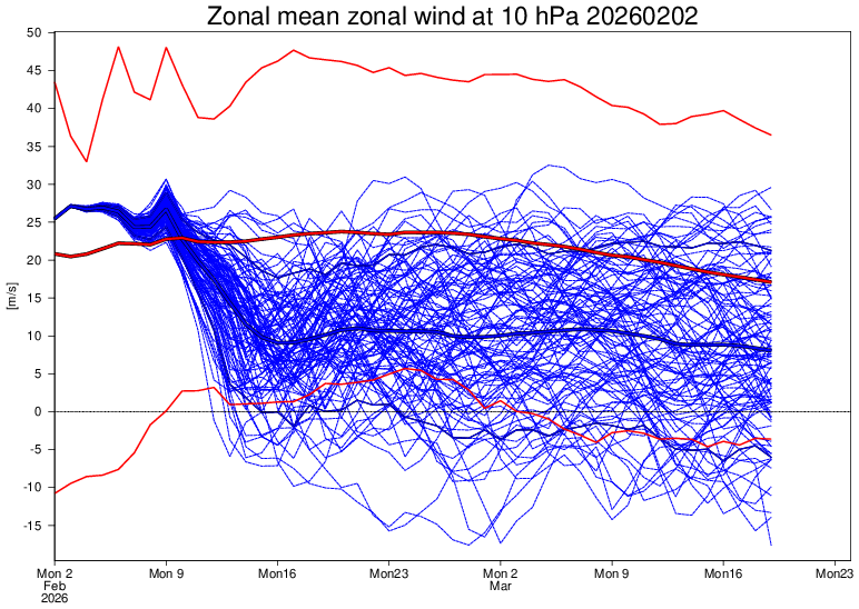
Today’s Euro Weeklies are if anything even worse than yesterday’s if you want a cold pattern in the E US. Also, the 10 mb has pulled up somewhat on the mid Feb reversal chance. Cue the folks that say the EW shouldn’t run daily lol, which is irrelevant unless you’d prefer to keep your head in the sand: