All Activity
- Past hour
-

2026 Mid-Atlantic Severe Storm General Discussion
dailylurker replied to Kmlwx's topic in Mid Atlantic
This post caused an eagle to gain it's wings. It should be a fin day of radar watching. I could really go for some severe. I might cut out of work around 2 and do a lightning chase this afternoon. -
That doesn't change the fact that it's initialization of the Pacific is off, so I would still adjust warmer....but that does make a little more sense.
-

Central PA Summer 2026 Discussion/Obs Thread
Blizzard of 93 replied to Voyager's topic in Upstate New York/Pennsylvania
I ended up with .67 of rain last night. -
The models haven’t done well showing the storms. Yesterday those storms that ripped ne and eastern Pa weren’t super well shown either. If that area holds together as the atmosphere gets unstable it could be an interesting afternoon.
-
10z hrrr made a big flip to carrying that Erie (I call it Lake Freedom now) cluster into central MD
- 2,291 replies
-
- 1
-

-
- severe
- thunderstorms
- (and 7 more)
-

2026-2027 Record-breaking El Nino
40/70 Benchmark replied to Stormchaserchuck1's topic in Weather Forecasting and Discussion
Sure, but we have good reasons to believe that it isn't. I could still doubt that you're one of NYC's finest after you show me your badge and a pic of you sleeping in the cruiser, but that doesn't change the facts. No runs are key if the model incessantly suffers from an erroneous initialization. Again, this doesn't necessarily mean an awful winter is en route, it just means that CANSIPS output is highly flawed. Maybe we will make out okay and score a HECS...both can be true, and in fact, I suspect that they are. -
2026-2027 Record-breaking El Nino
40/70 Benchmark replied to Stormchaserchuck1's topic in Weather Forecasting and Discussion
Yes, and I'm not being facetious....quite literally. -
2026-2027 Record-breaking El Nino
40/70 Benchmark replied to Stormchaserchuck1's topic in Weather Forecasting and Discussion
-AO/+PNA winter en route.....confirms what I had already figured. -
The Franklin Institute in Philly is the 90° day leader across the region this year. Data for January 1, 2026 through September 1, 2026 Click column heading to sort ascending, click again to sort descending. PA PHILADELPHIA FRANKLIN INSTITUTE COOP 43 MD STEVENSVILLE 2SW COOP 41 DE DOVER COOP 41 PA PHILADELPHIA INTL AP WBAN 40 Data for January 1, 2026 through September 1, 2026 Click column heading to sort ascending, click again to sort descending. NJ HARRISON COOP 35 NJ TETERBORO AIRPORT WBAN 29 NJ TETERBORO AIRPORT COOP 28 NJ NEWARK LIBERTY INTL AP WBAN 26
-
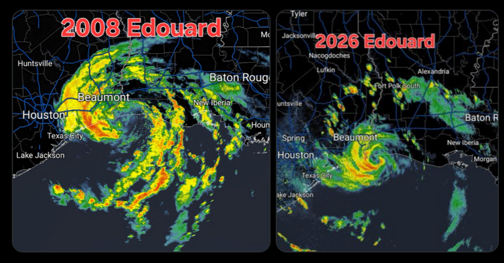
Over 20” in places now, flash flood emergency issued
-

Central PA Summer 2026 Discussion/Obs Thread
mahantango#1 replied to Voyager's topic in Upstate New York/Pennsylvania
Storm Chaser Brett Musser is in White Horse, Lancaster County, Pennsylvania. · Follow · Could there been a possible tornado here in Lancaster County this evening? Here is some of the damage from the White Horse area!! Part of a barn roof gone, a one room school house lost its whole roof, trees down on wires, and debris scattered across farm feilds!! All pics taken within a mile of each other. -
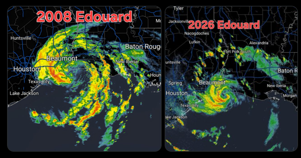
Some real bad flash flooding going on in that training band on the south side of Edouard. Radar estimates of up to 8" of rain in just the past 3 hours. Nearly 12-16" of rain total
-
90/56 yesterday, oppressive dews return today and look to stick around for awhile. 0.04” rain overnight. Drought begets drought
-
 top-rated online pharmacies and online pharmacy without prescription online drugs order http://hlsw.org/ajax/news_slides/default.php?link=https://quickph.com online pharmacy without scriptsand http://www.1gmoli.com/home.php?mod=space&uid=1032524 worldwide pharmacy [url=http://arigato.pro/forum/away.php?s=https://quickph.com]pharmacy online[/url] best rx pharmacy onlineor [url=https://brueckrachdorf.de/user/pbjbmnsuzc/]trusted online pharmacy[/url] us pharmacy no prescription
 -

2026-2027 Record-breaking El Nino
qg_omega replied to Stormchaserchuck1's topic in Weather Forecasting and Discussion
Record warmth summer and winter -

2026-2027 Record-breaking El Nino
bluewave replied to Stormchaserchuck1's topic in Weather Forecasting and Discussion
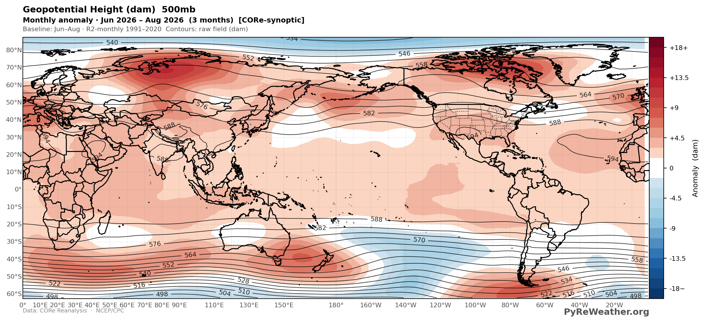
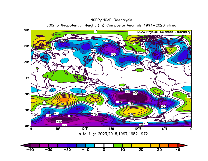
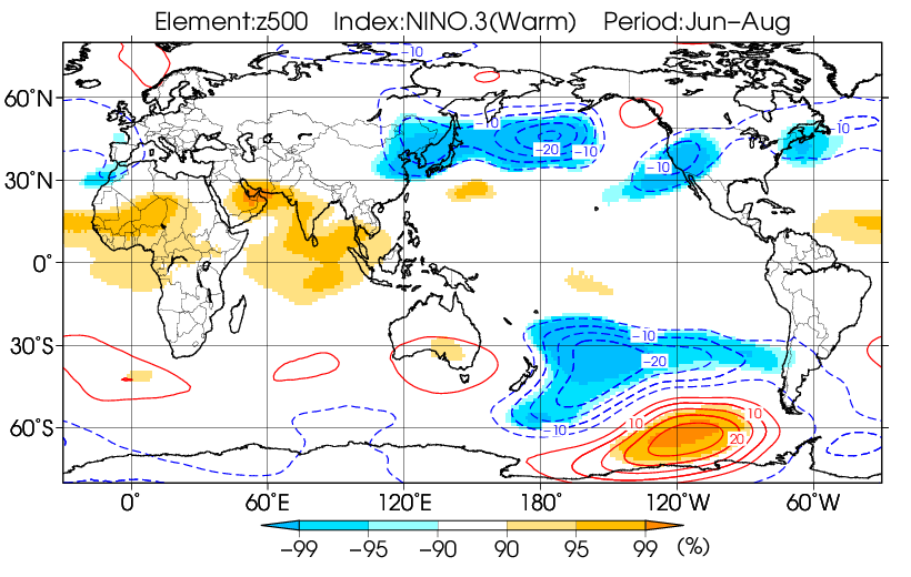
The summer 500 mb pattern was as opposite as you can get from a developing super El Niño in the Northern Hemisphere. The 500mb ridges dominated where the troughs were supposed to be. But the Southern Hemisphere response during their winter may give us some clues what to expect here. Notice how the 500mb ridges were stronger than the expected troughs. It was obvious near New Zealand and South America. This would translate into a weaker Aleutian Low and weaker low pressure near the Southeast U.S and or Western Atlantic than is usual for such a strong El Niño. Could mean a warmer more dominant ridge pattern over North America than is typically the case for a super El Niño event. Should this occur during our winter, then it would follow the general pattern regardless of ENSO of the 500mb ridges being more impressive than the troughs since the 2015-2016 super El Niño. https://www.pyreweather.org/map/?variable=height&level=500®ion=World&mode=anomaly&months=202606%2C202607%2C202608&fill_mode=shaded&climo_source=r2-monthly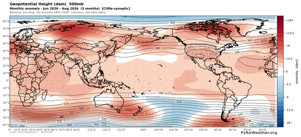
-
-
I think he could still be serviceable, but his days of every down work are probably vanquished. In the right scheme, he could certainly provide value. Considering Flores propensity to blitz, that should be favorable.
- Today
-
0z euro selling a p sick ridge roller pattern locally, want 2 believe
-
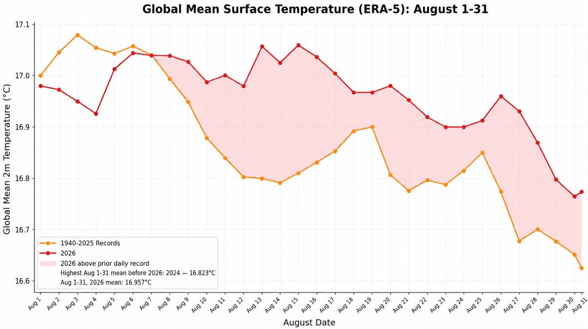
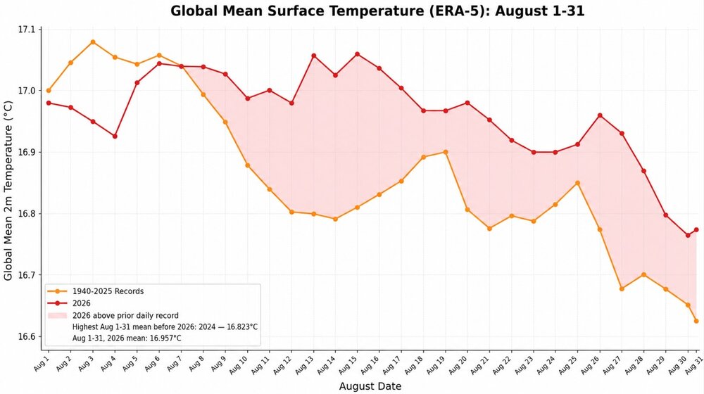
August 2026 finished with a preliminary monthly mean temperature of 16.957C. That would shatter the August mark of 16.823C from 2024. It would also edge past July 2023's 16.953C to become the warmest month on record in the ERA-5 dataset.
-
Central PA Summer 2026 Discussion/Obs Thread
mahantango#1 replied to Voyager's topic in Upstate New York/Pennsylvania
Where was the heat advisory, or warning yesterday when we needed it? -
Ravens fans, does Kyle Van Noy have anything left in the tank as a backup OLB?
-
I've been tracking since 2023. Over 1C daily is very warm but it has happened before mainly in the 23/24 nino. 1.04C in Nov 2023 is the highest monthly value. August was 0.942 the 5'th highest monthly value , the higher values were the last 4 months of 2023. Note that changes to the gfs model may change the metric.
-

Central PA Summer 2026 Discussion/Obs Thread
Mount Joy Snowman replied to Voyager's topic in Upstate New York/Pennsylvania
Low of 68 with .19” of rain. Amtrak is down this morning due to a fallen tree on the tracks near Philly. Damn. -
2026 Mid-Atlantic Severe Storm General Discussion
dailylurker replied to Kmlwx's topic in Mid Atlantic
I see our storms for later on over Lake Erie this morning. Lake Ontario also has a nice batch.- 2,291 replies
-
- 3
-

-
- severe
- thunderstorms
- (and 7 more)