All Activity
- Past hour
-
The 18z GFS has some snow, but not nearly the amount it did on the 12z. Will the next run go further east or west? It has been all over the place.
-

Winter 2025-26 Short Range Discussion
sbnwx85 replied to SchaumburgStormer's topic in Lakes/Ohio Valley
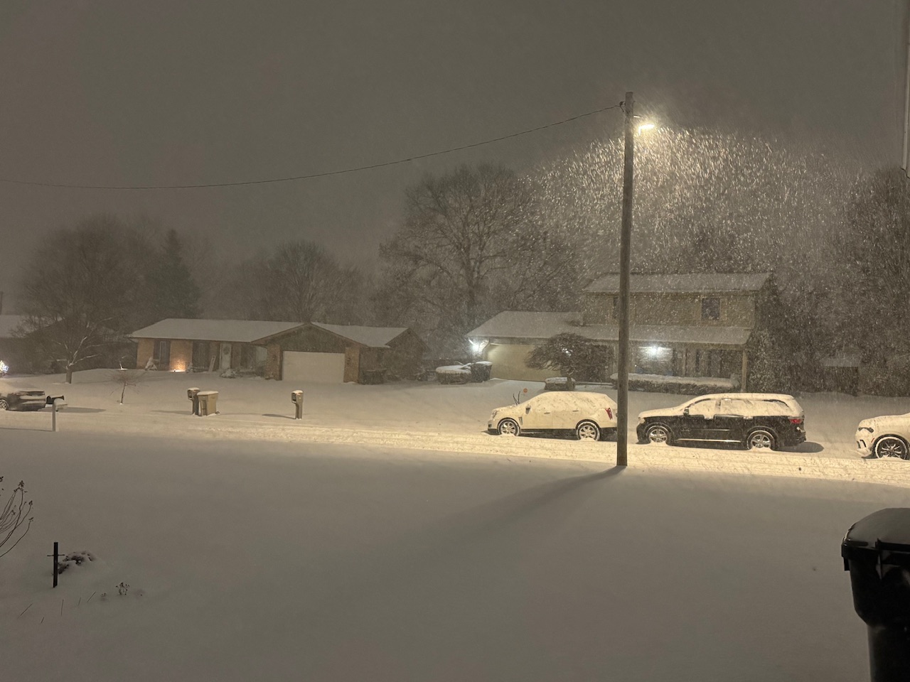
Up to 6” and still ripping. Probably 2-3” per hour rates.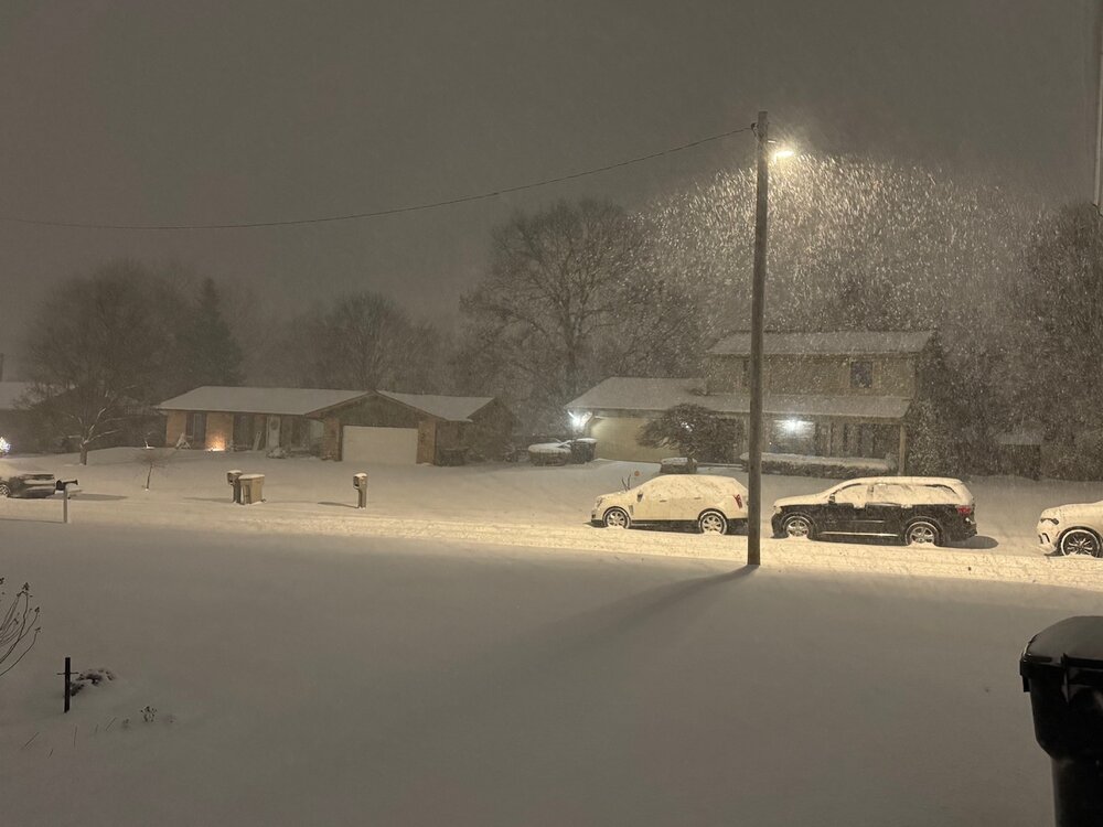
-

Winter 2025-26 Short Range Discussion
TheRegionRat replied to SchaumburgStormer's topic in Lakes/Ohio Valley
Snowed really hard at work in Hammond. Started as a mix, dropped some sleet, then snow. Unsalted areas remain icy. The further south you went, the more snow. At home, I have less than inch. The US 30 corridor has 3 inches or so. While the squall moved through visibility was awful. It was tough going from around 8AM through 9:30 or so. -

Pittsburgh/Western PA WINTER ‘25/‘26
TheClimateChanger replied to Burghblizz's topic in Upstate New York/Pennsylvania
Yeah, they were getting clobbered with moderate to heavy snow earlier. -

First Legit Storm Potential of the Season Upon Us
The 4 Seasons replied to 40/70 Benchmark's topic in New England
1-3?? Try widespread 4-8+ warning snow. You are misremembering a bit here. It was wet glop, but a legit storm. I enjoyed this more than that fake blizzard actually. It was a legit costal, check out the sfc animation. https://www.jdjweatherconsulting.com/jan-24-2015 -
My dad reports 5" on the ground in Oakland county.
-
18z EPS is slightly worse than 12z. Minor. No progress though.
-

2025-2026 Fall/Winter Mountain Thread
Buckethead replied to Buckethead's topic in Southeastern States
I'm eagerly awaiting this line. Sent from my Pixel 10 Pro using Tapatalk -

First Legit Storm Potential of the Season Upon Us
ineedsnow replied to 40/70 Benchmark's topic in New England
oh I'm not im just trying to get good juju flowing in the thread -

First Legit Storm Potential of the Season Upon Us
WinterWolf replied to 40/70 Benchmark's topic in New England
Ya you guys did a little better in that one(as you did throughout that whole crazy run lol), but here it was 3+ inches of glop as temps were borderline. -

Storm potential January 18th-19th
Franklin0529 replied to WeatherGeek2025's topic in New York City Metro
Not shocking coming from you. I wouldn't be surprised to see a 2-4" -

Pittsburgh/Western PA WINTER ‘25/‘26
colonel717 replied to Burghblizz's topic in Upstate New York/Pennsylvania
Detroit and Toledo over performed, so maybe we can get an over performer here -
Yes, but temps are AOA 32F for 95 and the coast while it's snowing and this is during daylight hours with light to moderate rates, so accumulation will be tough.
-
I feel like last years setup was super screwed because we watched an energy transfer happen. This one shouldn’t have that problem and is probably going to be more prone to a shift west, especially with heights rising over the Atlantic.
-

January 2026 regional war/obs/disco thread
Damage In Tolland replied to Baroclinic Zone's topic in New England
Saturday night -
For the Will I remember that might almost be like transitioning.. as always …..
-

First Legit Storm Potential of the Season Upon Us
weathafella replied to 40/70 Benchmark's topic in New England
I got 4-5 inches from the predecessor. 2 inches of glop but 2-3 more on the backside cementing the nascent pack. It was hard to imagine my grill completely submerged a few weeks later such that I had to wait until early spring to find it. -
I'm kinda torn on it. 18Z EPS looks like crap and didn't trend west like I hoped. The setup does scream NW trend but last year it didn't happen
-

January 2026 Medium/Long Range Discussion
Stormchaserchuck1 replied to snowfan's topic in Mid Atlantic
Today's storm is busting much snowier in the Detroit area. They were suppose to get flurries, and now have 4" -
My daughter said I should draw something on her doodle board. Yall think it avoids the east coast? Close shave at a minimum. .
-
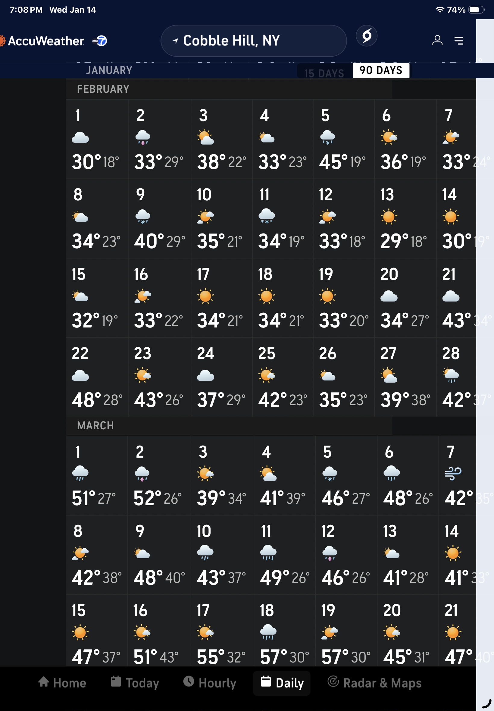
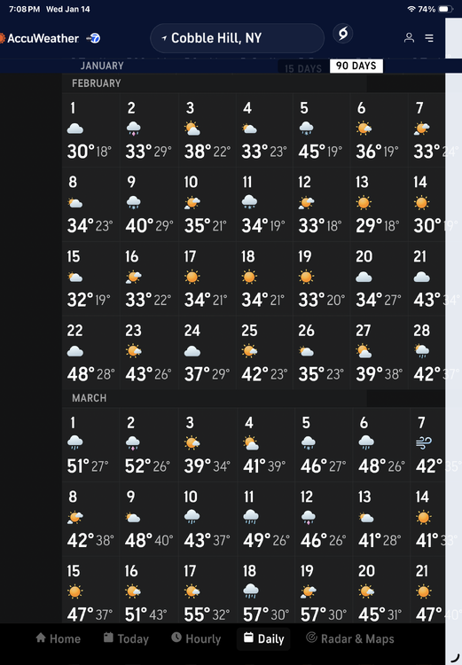
The Accu Weather long range forecast (which will undoubtedly change daily) must have bought into a colder scenario for the city. The first above 56 temperature is forecasted for the day after St Patrick’s on March 18th. Stay well, as always …
-

First Legit Storm Potential of the Season Upon Us
dryslot replied to 40/70 Benchmark's topic in New England
Just looking at the euro quickly while I was driving looks like it ticked west some. -
First Legit Storm Potential of the Season Upon Us
WinterWolf replied to 40/70 Benchmark's topic in New England
Eerily similar to late January 2015 when the predecessor event dropped 1-3 inches of wet glop that Friday night into Saturday morning, and then the big dog came back west on the 0z Euro that night/early morning. Of course nothing is ever identical, and not saying 2015 is walking in, but has a similar feeling, and similar look. With an extended look that looks promising as well. Just some observations that are similar to close to the same timeframe from 11 years ago. If anything perhaps just a week earlier this go around, compared to the start of 2015. -
First Legit Storm Potential of the Season Upon Us
dryslot replied to 40/70 Benchmark's topic in New England
Oh boy! -
A range of 27-67 can be anticipated as examples