All Activity
- Past hour
-

Possible Record Breaking Cold + Snow Sunday 1/25 - Tuesday 1/27
NorthShoreWx replied to TriPol's topic in New York City Metro
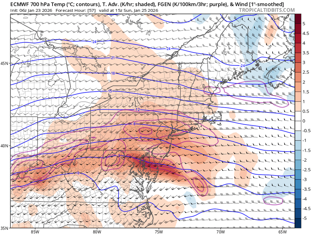
I'm pretty confident it will taint, but I think the somewhat weak consensus in this thread is overestimating the magnitude of it. I looked at soundings on a couple of models last night that showed the warmest part of the column at about -2C at my location aligned with a p-type map where we were deep into the purple. Gives me more confidence in the NWS sticking to their guns. I'm eager to see NAM soundings once most of the storm gets within 60 hours. -
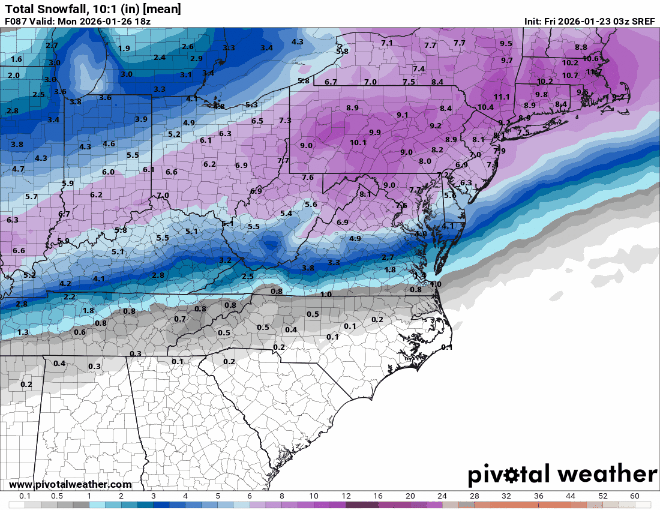
 There will still be a nice thump of snow but IMO the bigger story is becoming the sleet. 6-10" of snow with a ton of sleet on top is going to be create big problems in the coming days with the very cold week coming up and it icing up even further.
 -

January 25-26 Winter Storm Potential
The Iceman replied to Ralph Wiggum's topic in Philadelphia Region
Trust the pro’s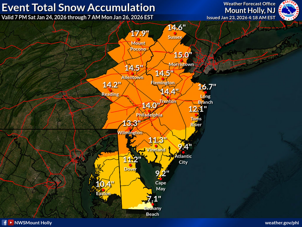
-

January 24-26: Miracle or Mirage JV/Banter Thread!
NorthArlington101 replied to SnowenOutThere's topic in Mid Atlantic
Feel like it’s EURO without the ability to discern sleet/snow/FRZA -
Well, 9z Srefs are colder and snowier than 3z for areas at and north of Fredericksburg; southern extent tightened up a bit. We take anything that shows improvement no matter how small. Just a reminder to those who may not know, Srefs are an ensemble product and not a seperate model.
-
How do they decide between winter storm warning and ice storm warning? If ice storm criteria is met it will always be ice storm warning?
-
I lol'd, I always remind everyone i don't know jack, but it always feels like in these scenarios warm air aloft is under modeled. I can't remember many times where a mix was involved and it was either delayed further out or didn't happen. Sorry will clean that up because I don't want to creative a negative experience here as I too love this forum
-

Pittsburgh/Western PA WINTER ‘25/‘26
dj3 replied to Burghblizz's topic in Upstate New York/Pennsylvania
Seems like everything has stayed solid although the euro looks to have cut back on precip totals a hair showing less than 1.00 in liquid. -
Good luck all. Hope you all see some good snows before any ice down there
-

Possible Record Breaking Cold + Snow Sunday 1/25 - Tuesday 1/27
MJO812 replied to TriPol's topic in New York City Metro
And possible another storm next weekend -
 I've been a 4 my whole life
 -

Richmond Metro/Hampton Roads Area Discussion
Rvarookie replied to RIC Airport's topic in Mid Atlantic
It’s got the feels to over-perform -

January 24-26: Miracle or Mirage JV/Banter Thread!
yoda replied to SnowenOutThere's topic in Mid Atlantic
I'm going to get 0.01" more snow than you. But @mappy will get more than both of us -

1/24-1/25 Major Winter Storm - S. IL, IN, MI and OH
A-L-E-K replied to A-L-E-K's topic in Lakes/Ohio Valley
GFS really owned the competition this time around -

1/24-1/25 Major Winter Storm - S. IL, IN, MI and OH
mimillman replied to A-L-E-K's topic in Lakes/Ohio Valley
-
It is supposed to be very cold tonight. I dumped ice from a party Sunday night on my yard. It's still here today. But the ground won't be a HARD freeze. So you are probably right. I think most areas will get nearly to the point of big problems but then flip to rain. I anticipate that to be a theme maybe even in NC too.
-
I think most of us are pretty set on getting at least 6" of snow. What happens after is up to banding location and other intricacies. As others have mentioned, if we want to get closer to double digit snow amounts in the metros... we want that mix to come closer to 18z
-
Winter 2025-26 Medium/Long Range Discussion
A-L-E-K replied to michsnowfreak's topic in Lakes/Ohio Valley
worst call of they year x too real classic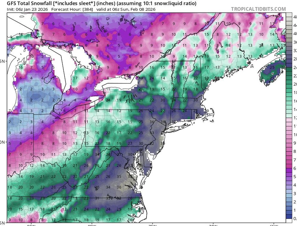
-
Looks like GSP will wait for another round of model runs before deciding on the specific warning. You know it’s going to be difficult when the short term guidance that always runs warm is the coldest of them all
-
Someone....Hopefully many of us.....will be getting a beatdown on Sunday morning.

-

January 25-26 Winter Storm Potential
Thesmithsinde replied to Ralph Wiggum's topic in Philadelphia Region
"Long" time lurker, learner, thank you ! What's is a time frame for start up in Mid Delaware? We'll be at a wedding in KOP area Sat Night and trying to plan out what time to bug out of it to get home. Thanks again. -
Also charlotte spent all that time and effort brining the roads just for it to all wash away overnight.
-

Central PA Winter 25/26 Discussion and Obs
Blizzard of 93 replied to MAG5035's topic in Upstate New York/Pennsylvania
Great write up by CTP. -
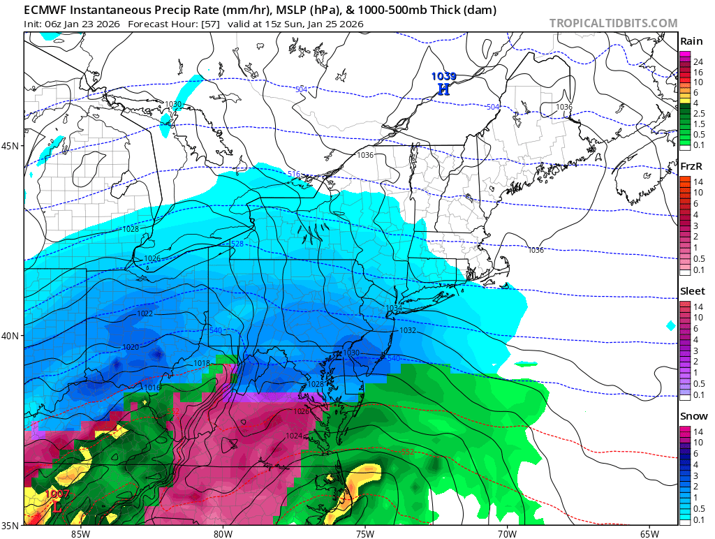
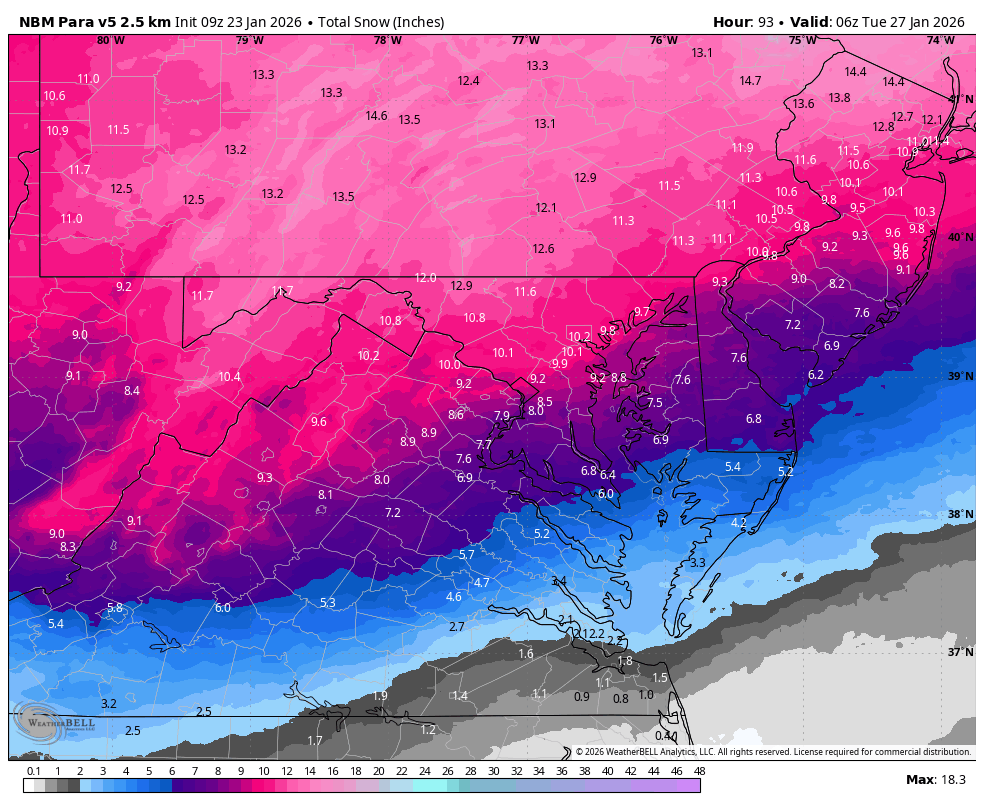
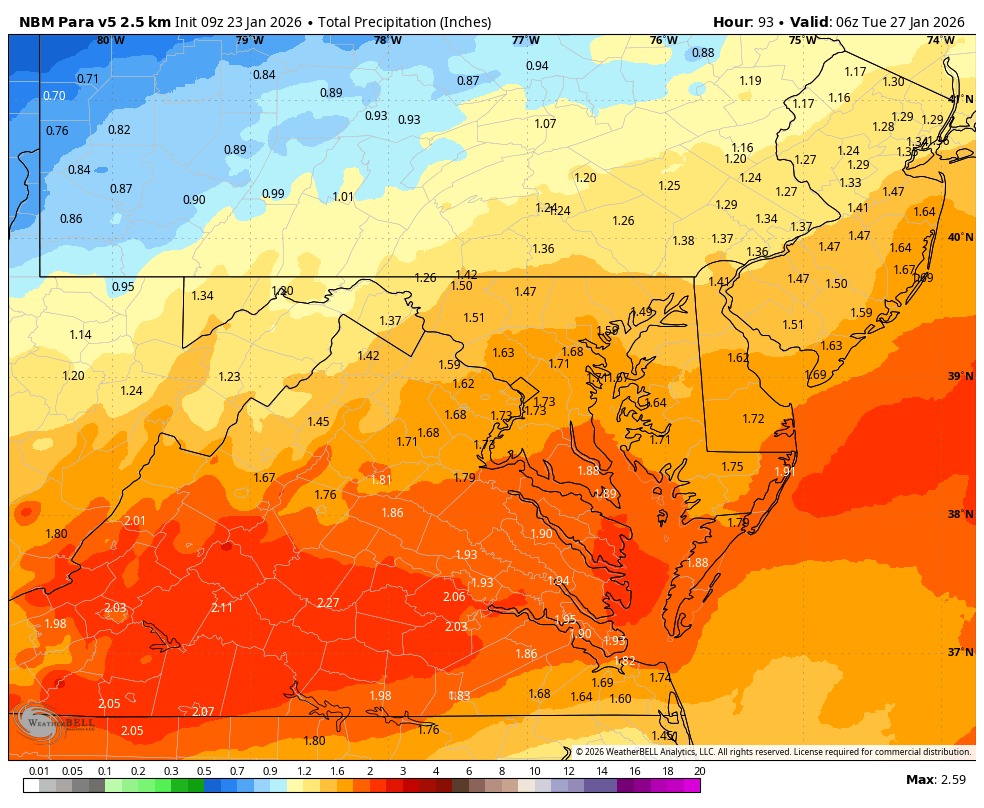
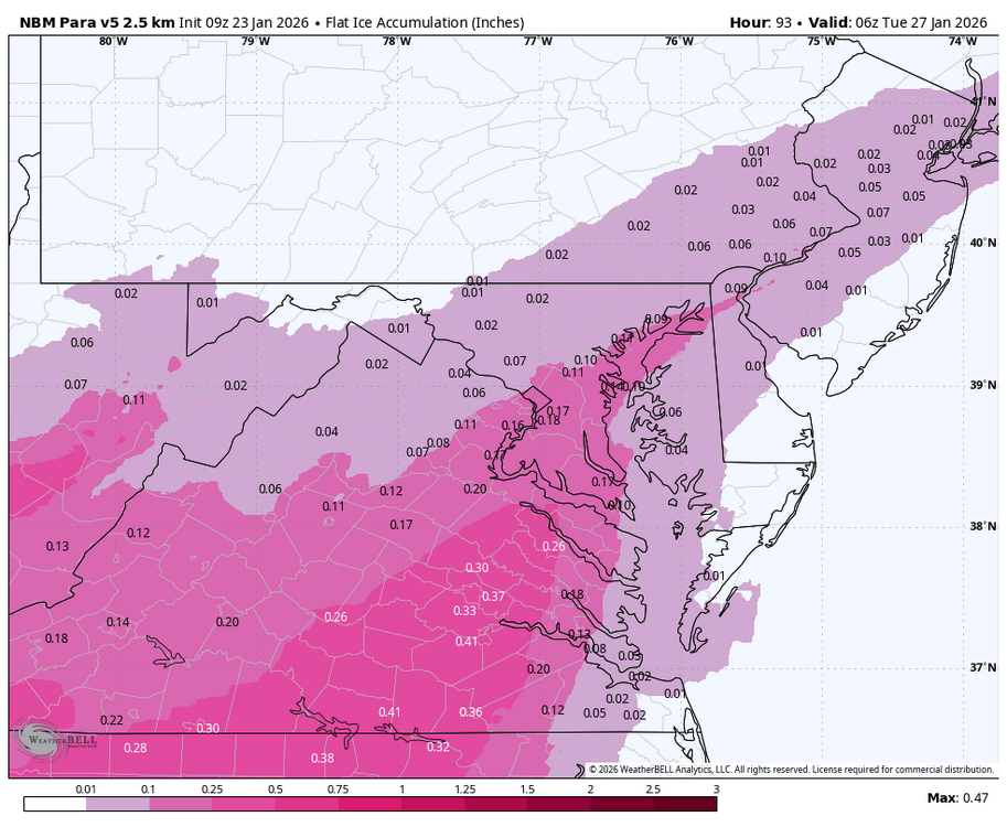
WB 9Z NBM para


-

“Cory’s in LA! Let’s MECS!” Jan. 24-26 Disco
WxWatcher007 replied to TheSnowman's topic in New England
As an aside, look at that high nosing into the central U.S. Beautiful