All Activity
- Past hour
-
Was wondering if peepers would get going soon
-
Birds are now here in full effect. Also noticed the peepers a couple nights ago. only the largest snowbanks are left here. No ground cover.
-

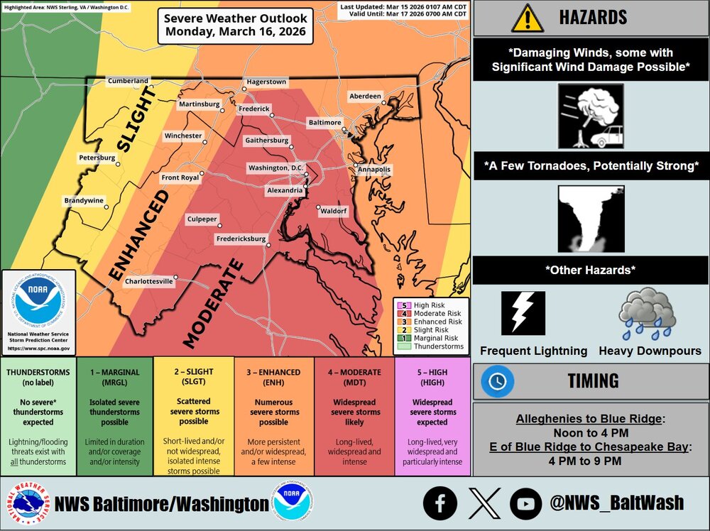
3/16/26 Severe Weather Event Thread (Day 2 MOD Risk)
SomeguyfromTakomaPark replied to Kmlwx's topic in Mid Atlantic
Wow, haven’t seen this in a while. Maybe August 2023 was the last moderate risk day here? At least the QLCS holds off until after school dismissal and kids have a chance to get home. -
Well that was a swing and a miss for MSP. Idk what it’ll take to get a storm to live up to the hype around here. .
-
Happy to have nothing to do with this one on Selection Sunday March 15th is for 65 degrees and day drinking. Hard pass on any snow.
-
Very active Monday likely. If we get higher dews/temps and more sun than forecast then wind/tornado threat goes way up
-
Hoping for 60+, but probably will end up 50-55mph here and 60-70 out East
-

3/16/26 Severe Weather Event Thread (Day 2 MOD Risk)
snowfan replied to Kmlwx's topic in Mid Atlantic
-
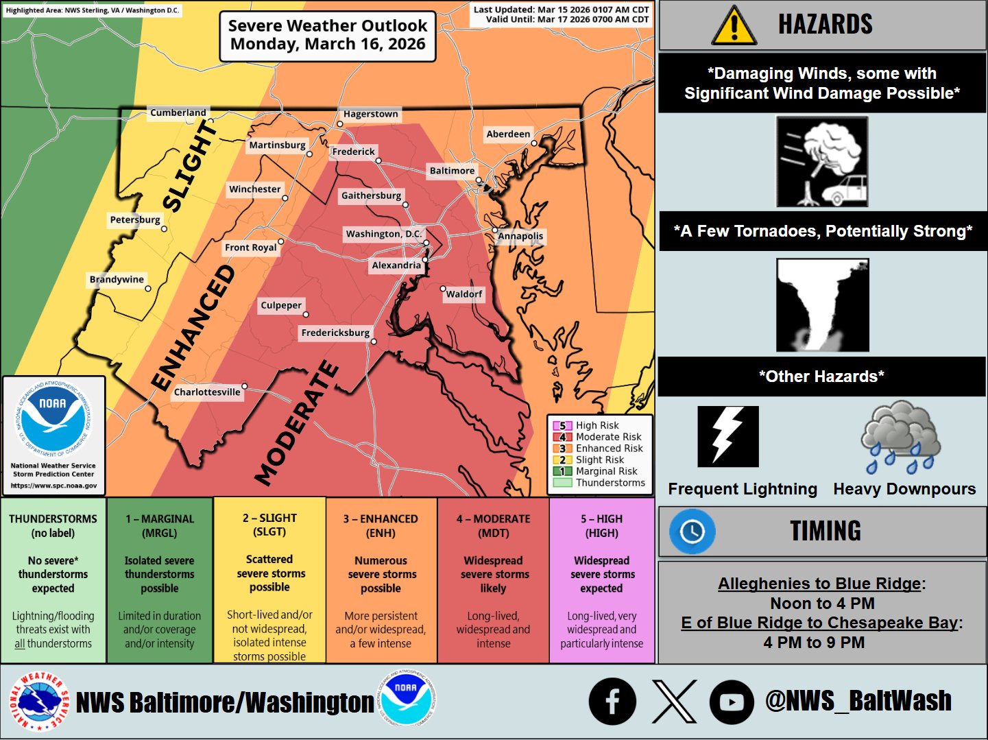
Continuing discussion and eventually observations/nowcast posts for the Monday severe weather event potential can go here. @WxUSAF or other mods please pin this thread if you get the chance. 15% TOR and 60% WIND are extremely rare in these parts. While I am not downplaying anything - I do think the appearance of 60% wind has a lot to do with the new SPC outlook methodology. Nonetheless, an active weather day tomorrow seems on tap. Usual failure modes still exist (stabilizing cloud cover or early day showers) The shear environment is pretty insane.
-
Ditty finally gets his siggy damaging wind event?
-
Thankfully normal highs are well in the 50’s in the NYC metro area now that we’re in spring, so those depicted negative departures are not actually cold
-

Pittsburgh/Western PA WINTER ‘25/‘26
Burghblizz replied to Burghblizz's topic in Upstate New York/Pennsylvania
0Z NAM with a mini-Namming, showing 6”+ with the frontal passage of the big Midwest storm Monday afternoon. As you would expect, that backed off a little this morning Will still be interesting to see if that’s just a little white rain, or if there can be a period of accumulating snow. -
NAM is still pretty wild with that LLJ…pushing 100kt at 925. It’s a little inverted on soundings, but we could be pushing 60/58 type air over the interior. Other models are a little more tame so the NAM is probably overdone. It’ll be interesting to see how much we can mix down. Getting those dews near 60° in March wouldn’t normally worry you about being inverted.
- Today
-
It's over for the co river Been over for a long time but this starts the death spiral
-
Ready for 1.5 to 2 inches (of rain) and an exciting dab
-
Imagine you booked an extremely expensive Hawaiian vaca and this is your weather
-
I'll get a separate thread started in a bit!
- 254 replies
-
- 2
-

-
- severe
- thunderstorms
- (and 7 more)
-
Temp right below freezing here at 31.5 Convective shower just moved through and woke me up with a nice burst of sleet
-
Better Image
-
4 of those winters were colder than normal in the northeast (88-89 the exception I believe) . Western ridge patterns?
-

Mid-Long Range Discussion 2026
WinstonSalemArlington replied to BooneWX's topic in Southeastern States
Unfortunately, I stole it from someone who didn’t -
.thumb.jpg.6a4895b2a43f87359e4e7d04a6fa0d14.jpg)
Central PA Spring 2026 Discussion/Obs Thread
Yardstickgozinya replied to Voyager's topic in Upstate New York/Pennsylvania
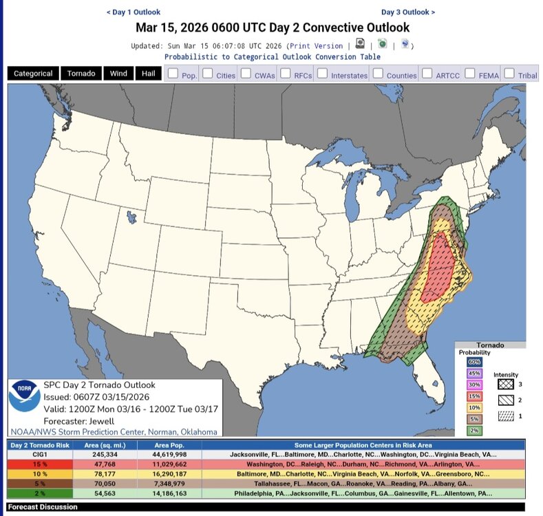
Spc's new severe wind and tornado probability outlook.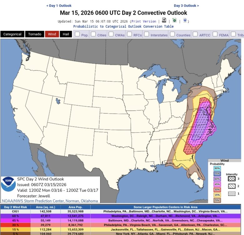
-
The 03Z RAP gives 2-4 inches from the western Plateau to the Mountains. Valley areas included, even down into NE Alabama and NW Georgia.
-
Central PA Spring 2026 Discussion/Obs Thread
Yardstickgozinya replied to Voyager's topic in Upstate New York/Pennsylvania
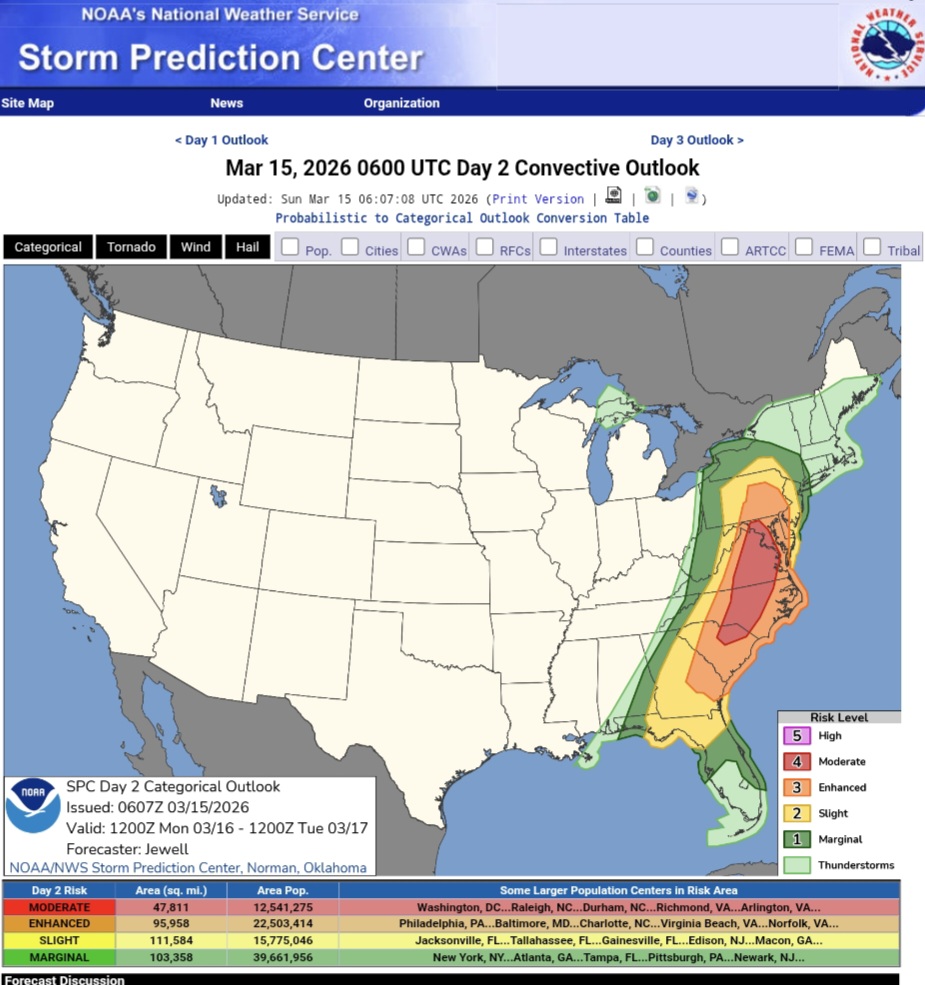
New update from the Spc . A zone of moderate risk has been added. Its definitely not looking good fellas, and I don't know that things will de escalate, at least on paper so let's hope for a thermodynamic failure at the lowest levels because the crazy, kinematics seem pretty eminent. Full discussion is in the link below the map. ...Carolinas into MD/PA and vicinity... Areas of showers may occur early in the day especially but should rapidly lift north, allowing areas of heating and gradual destabilization over the entire area. As the surface trough deepens, low-level wind will back and strengthen throughout the day. Supercells producing tornadoes appear most likely ahead of the cold front from SC into NC and southern VA. Models vary with degree of instability, but strong tornadoes do appear possible with effective SRH of at least 300-400 m2/s2. Fast storm motions over 50 kt suggest a long tracked tornado will be possible https://www.spc.noaa.gov/products/outlook/day2otlk.html
-
That NAM run.