yoda Posted August 1, 2016 Share Posted August 1, 2016 No recon for now NHC Atlantic Ops @NHC_Atlantic 4m4 minutes ago Reconnaissance aircraft returning home due to maintenance issues. Also, no watches or warnings to be issued at 5pm either NHC Atlantic Ops @NHC_Atlantic 44m44 minutes ago NHC is not planning to start advisories on the Caribbean wave at 5 pm EDT. An aircraft is expected to be in the area shortly after 5 pm. Link to comment Share on other sites More sharing options...
the ghost of leroy Posted August 1, 2016 Share Posted August 1, 2016 13 minutes ago, yoda said: No recon for now NHC Atlantic Ops @NHC_Atlantic 4m4 minutes ago Reconnaissance aircraft returning home due to maintenance issues. Also, no watches or warnings to be issued at 5pm either NHC Atlantic Ops @NHC_Atlantic 44m44 minutes ago NHC is not planning to start advisories on the Caribbean wave at 5 pm EDT. An aircraft is expected to be in the area shortly after 5 pm. time for congress to properly fund NOAA and the AFHH's. seems like every other flight these days has a mechanical error, broken SFMR, or some other issue that prevents or degrades data collection. Link to comment Share on other sites More sharing options...
MazooWeather Posted August 2, 2016 Share Posted August 2, 2016 From the satellite over the past 2-3 hours, I'd expect the Invest to be christened Tropical Storm Earl shorty. Link to comment Share on other sites More sharing options...
MazooWeather Posted August 2, 2016 Share Posted August 2, 2016 And.... Nope. TWD out, no upgrade. Surprised. Link to comment Share on other sites More sharing options...
Scott747 Posted August 2, 2016 Share Posted August 2, 2016 No reason for an upgrade yet, and there was little chance of one with recon scheduled later this morning. Still not the healthiest looking system. Needs another 12hrs or so.... Link to comment Share on other sites More sharing options...
DopplerWx Posted August 2, 2016 Share Posted August 2, 2016 4 hours ago, Scott747 said: No reason for an upgrade yet, and there was little chance of one with recon scheduled later this morning. Still not the healthiest looking system. Needs another 12hrs or so.... yea still looks like a bit of a mess on ir, plenty of convection though. Link to comment Share on other sites More sharing options...
Eskimo Joe Posted August 2, 2016 Share Posted August 2, 2016 Given it's proximity to land, I'm surprised NHC didn't designate it a TD. There's been a debate ongoing where the islands can't issue tropical headlines without a designation of at least a TD, but I think that's changing at the end of this season. Link to comment Share on other sites More sharing options...
hawkeye_wx Posted August 2, 2016 Share Posted August 2, 2016 97L is a disorganized mess this morning. The exposed surface vort has shot out ahead of the convection, sw of Jamaica. Link to comment Share on other sites More sharing options...
Drz1111 Posted August 2, 2016 Share Posted August 2, 2016 9 minutes ago, hawkeye_wx said: 97L is a disorganized mess this morning. The exposed surface vort has shot out ahead of the convection, sw of Jamaica. Yep. Of course, the "exposed surface vort" suggests that this should've been a TS before the shear got to it. Link to comment Share on other sites More sharing options...
Akeem the African Dream Posted August 2, 2016 Share Posted August 2, 2016 Special advisory on the way. TS Earl @ noon Link to comment Share on other sites More sharing options...
yoda Posted August 2, 2016 Share Posted August 2, 2016 BULLETIN TROPICAL STORM EARL SPECIAL ADVISORY NUMBER 1 NWS NATIONAL HURRICANE CENTER MIAMI FL AL052016 1200 PM EDT TUE AUG 02 2016 ...AIR FORCE HURRICANE HUNTER PLANE FINDS TROPICAL STORM EARL IN THE NORTHWESTERN CARIBBEAN SEA... ...EARL IS THE FIFTH TROPICAL STORM OF THE 2016 HURRICANE SEASON... SUMMARY OF 1200 PM EDT...1600 UTC...INFORMATION ----------------------------------------------- LOCATION...16.3N 80.2W ABOUT 215 MI...350 KM SSE OF GRAND CAYMAN ABOUT 535 MI...860 KM E OF BELIZE CITY MAXIMUM SUSTAINED WINDS...45 MPH...75 KM/H PRESENT MOVEMENT...W OR 270 DEGREES AT 22 MPH...35 KM/H MINIMUM CENTRAL PRESSURE...1001 MB...29.56 INCHES WATCHES AND WARNINGS -------------------- CHANGES WITH THIS ADVISORY: The Governments of Mexico and Belize have issued a Tropical Storm Warning and a Hurricane Watch for the east coast of the Yucatan peninsula from Punta Allen, Mexico, southward to the Belize/ Guatemala border. The Government of Honduras has issued a Tropical Storm Warning for the entire north coast of Honduras from Cabo Gracias a Dios westward to the Honduras/Guatemala border including the Bay Islands. SUMMARY OF WATCHES AND WARNINGS IN EFFECT: A Tropical Storm Warning is in effect for... * Punta Allen, Mexico, southward to the Belize/Guatemala border. A Tropical Storm Warning is in effect for... * Cabo Gracias a Dios westward to the Honduras/Guatemala border including the Bay Islands. A Hurricane Watch is in effect for... * East coast of the Yucatan peninsula from Punta Allen, Mexico, southward to the Belize/Guatemala border. Link to comment Share on other sites More sharing options...
yoda Posted August 2, 2016 Share Posted August 2, 2016 000 WTNT45 KNHC 021557 TCDAT5 TROPICAL STORM EARL SPECIAL DISCUSSION NUMBER 1 NWS NATIONAL HURRICANE CENTER MIAMI FL AL052016 1200 PM EDT TUE AUG 02 2016 Data from an Air Force reconnaissance plane indicate that the strong wave we have been tracking for days has developed a closed circulation center with an estimated pressure of 1001 mb. On this basis, advisories on Tropical Storm Earl have been initiated. This is the fifth tropical storm of the 2016 hurricane season. The overall convective pattern was a little less organized this morning, but recent images indicate that an area of deep convection is forming near or over the center. The upper-level outflow is not well established yet in all quadrants due to some shear. Most of the global models show that the upper-level environment should become more favorable with less shear. The NHC forecast calls for some intensification, and Earl is expected to be near hurricane strength by the time the center approaches the Yucatan peninsula. Earl has been moving westward rapidly around 19 kt embedded within very strong easterly flow around the periphery of the Atlantic subtropical high. The ridge extends westward across the southern United States, and this pattern should maintain the cyclone on a general westward track across Belize and Yucatan during the next couple of days. After that time, a weakened Earl should move over the southern Bay of Campeche and southern Mexico. The cyclone should slow down during the next 12 to 24 hours since the steering currents are expected to be weaker. Most of the dynamical guidance agree on this scenario, and the NHC forecast very closely follows the multi-model consensus. FORECAST POSITIONS AND MAX WINDS INIT 02/1600Z 16.3N 80.2W 40 KT 45 MPH 12H 03/0000Z 16.3N 82.6W 45 KT 50 MPH 24H 03/1200Z 17.0N 85.2W 50 KT 60 MPH 36H 04/0000Z 17.5N 87.5W 55 KT 65 MPH 48H 04/1200Z 18.0N 90.0W 30 KT 35 MPH...INLAND 72H 05/1200Z 19.2N 94.0W 40 KT 45 MPH...OVER WATER 96H 06/1200Z 20.0N 98.0W 25 KT 30 MPH...INLAND 120H 07/1200Z...DISSIPATED $$ Forecaster Avila Link to comment Share on other sites More sharing options...
wxmx Posted August 2, 2016 Share Posted August 2, 2016 Earl has slowed down, and with that, the part of shear that was induced due to the fast forward motion has slackened. That is confirmed by the much better outflow seen in the western half, where earlier today had impinged Earl from the NW. If we add to that that the convection is in much better shape, I think Earl will soon enter a strengthening phase that should last until landfall...enough time to probably get into hurricane status. Link to comment Share on other sites More sharing options...
Snow_Miser Posted August 3, 2016 Share Posted August 3, 2016 Not too shabby... Could be looking at the second hurricane of the season not too long from now. Link to comment Share on other sites More sharing options...
Jason WX Posted August 3, 2016 Author Share Posted August 3, 2016 Earl has plenty of warm waters ahead of it. Should strengthen further more Link to comment Share on other sites More sharing options...
wxmx Posted August 3, 2016 Share Posted August 3, 2016 Earl is a nice looking tropical storm Link to comment Share on other sites More sharing options...
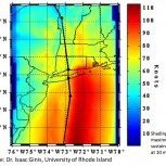
radarman Posted August 3, 2016 Share Posted August 3, 2016 Belize radar as Earl approaches and a cool PPI from the NOAA aircraft radar Link to comment Share on other sites More sharing options...
Snow_Miser Posted August 4, 2016 Share Posted August 4, 2016 Earl definitely trying to tighten up some more as it approaches Belize. Probably a 70 or 75 KT storm at landfall is my best guess. Link to comment Share on other sites More sharing options...
wxmx Posted August 4, 2016 Share Posted August 4, 2016 Land will preclude what would otherwise have been a very possible RIC Link to comment Share on other sites More sharing options...
Amped Posted August 6, 2016 Share Posted August 6, 2016 Not looking good for the start of Cape Verde season, lots of dry air across the Atlantic mdr. Link to comment Share on other sites More sharing options...
USCAPEWEATHERAF Posted August 7, 2016 Share Posted August 7, 2016 MId level low north of PR is now underneath the deepest convection associated with the tropical wave. Link to comment Share on other sites More sharing options...
WxReese Posted August 8, 2016 Share Posted August 8, 2016 I was on a cruise in the NW Caribbean last week and we went through the northern feeder band of Hurricane Earl. These pictures were taken Wednesday evening around 7 PM EDT as we traveled from Cozumel to Grand Cayman and was the first batch of rain/wind we had experienced. We easily experienced 40-45 knot wind and likely gusted higher than that at times. Needless to say, I got a little seasick that night. Still, it was pretty amazing to experience the fringe of a hurricane on open water. It's also something I would prefer not doing again. ETA: Here's a satellite loop of the storm as it moved through the Caribbean. We sailed ran in to the storm around the :36-ish mark and stayed in it for a few hours. Link to comment Share on other sites More sharing options...
NorthShoreWx Posted August 10, 2016 Share Posted August 10, 2016 RIP Gil Clark (NHC retired) http://www.nhc.noaa.gov/news/20160810_pa_GilClark.pdf Great Gil Clark quote in one of the Florida papers many years ago: 'If I could do anything about the weather it would be bad all the time' One senses he might have hung around longer if this was an active season. Link to comment Share on other sites More sharing options...
Amped Posted August 14, 2016 Share Posted August 14, 2016 Euro finally showing some action in the east Atlantic day 4-10 Link to comment Share on other sites More sharing options...
Sophisticated Skeptic Posted August 14, 2016 Share Posted August 14, 2016 18z gfs mildly hints at tropical development with this stubborn low in the gulf...during the next 72'ish hours. east texas / western LA area. Link to comment Share on other sites More sharing options...
shaggy Posted August 15, 2016 Share Posted August 15, 2016 6z GFS 384 hour shows a SW Atlantic cane. Of course its the 384 hr GFS so. Link to comment Share on other sites More sharing options...
Jason WX Posted August 15, 2016 Author Share Posted August 15, 2016 GFS and ECMWF have development in the coming weeks Link to comment Share on other sites More sharing options...
Kmlwx Posted August 15, 2016 Share Posted August 15, 2016 1 hour ago, shaggy said: 6z GFS 384 hour shows a SW Atlantic cane. Of course its the 384 hr GFS so. The 0z Euro has something a ways east of the Leewards at 240. So at least there's some loose agreement there with the GFS. Hopefully we are coming out of the boring tropical streak (excluding Earl) Link to comment Share on other sites More sharing options...
USCAPEWEATHERAF Posted August 16, 2016 Share Posted August 16, 2016 Invest 98L looks to be developing a nice circulation now with strong to deep convection over the eastern circulation center which appears to becoming dominant now. Link to comment Share on other sites More sharing options...
tmagan Posted August 17, 2016 Share Posted August 17, 2016 I'm noticing the NHC is now referring to the Cape Verde islands as the Cabo Verde Islands. Link to comment Share on other sites More sharing options...

Recommended Posts
Archived
This topic is now archived and is closed to further replies.