

hawkeye_wx
-
Posts
6,320 -
Joined
-
Last visited
Content Type
Profiles
Blogs
Forums
American Weather
Media Demo
Store
Gallery
Everything posted by hawkeye_wx
-
2.14" of rain fell this evening from the big MCS. The daily total is 2.43". This is my second 2+" rain event in the last week. July is up to 4.98". We had 3" in all of June.
-

2025 Short Range Severe Weather Discussion
hawkeye_wx replied to Chicago Storm's topic in Lakes/Ohio Valley
I got 1.78" from the line. -
2025 Short Range Severe Weather Discussion
hawkeye_wx replied to Chicago Storm's topic in Lakes/Ohio Valley
Nothing severe here, and very little, weak, thunder like always, but the wind is gusty and the rain is torrential. I've received an inch in only 15 minutes. I may exceed 2" based on radar. Radar shows a big eastward surge just north of Cedar Rapids. There is likely stronger wind up there. -
2025 Short Range Severe Weather Discussion
hawkeye_wx replied to Chicago Storm's topic in Lakes/Ohio Valley
First tornado watch of the season (I think) has been issued for Cedar Rapids. -
The heavier cells have missed me so far. I got a few tenths yesterday and a few tenths early this morning. The storms later today could fire over me or mostly south and east. Some good sunshine would help.
-
Models are pretty bullish for northern Illinois tonight. Training storms could produce some big rain totals.
-
Summer 2025 Medium/Long Range Discussion
hawkeye_wx replied to Chicago Storm's topic in Lakes/Ohio Valley
Medium-range models had been drying out through mid July, generally showing below average rain around here. However, we got the 2" event a few days ago and now the EPS is creeping back up again with precip across the region. With ridging in the nw and ne US, the upper midwest should be in a decent spot for moderate temps and regular rain chances. -
Fortunately, one of the heavy bands set up over Cedar Rapids. Once again there was very little thunder, but I got a much-needed 2.21" of rain.
-
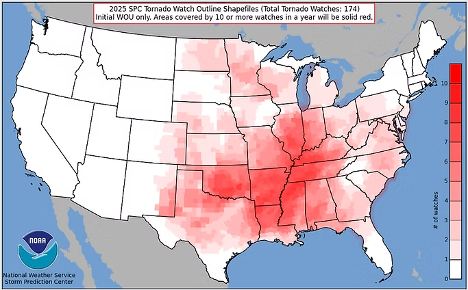
Zero tornado watches in eastern Iowa this year.
-
Last night's weakening crap dropped 0.45" here, which makes my weekly total 1.39". So, we basically got average rain out of this "wet" pattern. My June total is only 3.09, which is 2" below average.
-
It appears a broken, weakening line of showers and storms this evening will be it for the week. As Cyclone said, this ROF pattern has been lousy. The heat and humidity is there, but the other ingredients are all weak.
-
Yep. It's late June and we are still waiting for the first MCS activity of the year. Storm season has been a dud.
-
I got 0.64" overnight. It was more weakening crap with little lightning/thunder, but at least it was something. The rest of the week now doesn't look great as everything goes back north, leaving only spotty activity here.
-
Cedar Rapids only made it to 93º both days this weekend, with a dew in the mid 70s, pretty standard for a moderate heat wave.
-
The NWS forecast often has upper 90s during these heat waves, but we rarely get higher than low to mid 90s.
-
All I got was a little bit of light rain. It took all morning just to get 0.12". As often happens with these summer morning storm events, it was fed from the backside by a low level jet. The nose of the jet remained to my west, so the storms continued to back-build, and any storm that tried to move east of that LLJ nose quickly vanished. Only a couple counties west and northwest widespread 1-3" fell. The year without thunderstorms continues, as if winter wasn't boring enough. Maybe next week's ring of fire pattern can finally produce something.
-
Maybe. Hopefully. The ridge is pretty strong.
-
The model trend is to keep much of the ring-of-fire storms to my northwest next week. There could be a band of several inches of rain up there while southeast Iowa and points east and south get nothing but heat.
-
Recon found 953 mb.
-
Yesterday's plains convection drove this system well south of the model forecast. It's a big bust for many locations across Iowa. I'm at least getting one more decent batch of general rain this morning. We are getting into late June, but we are still waiting for our first good thunderstorm. The vast majority of our rain this spring has been the stratiform type with little to no thunder.
-
We have received 0.53" of rain (all on June 3rd) since May 22nd. This is the time of year when we average 1.25" per week. The lawns are beginning to brown. From 2007 to 2016, I averaged 8" of rain in June, a pretty crazy wet stretch. We have not even reached average rain in June since 2020.
-
While we missed out on rain this week, the next two weeks are looking fairly warm and stormy.
-
2025 Short Range Severe Weather Discussion
hawkeye_wx replied to Chicago Storm's topic in Lakes/Ohio Valley
The line of storms that moved ese-ward across northern Iowa yesterday produced a long path of 60-70 mph wind. They crapped out just north of me, but I still got 40 mph gusts from the outflow. -
Yesterday morning's Euro run was just a tease. The mid to late-week storms have been lifted north again. Most models show little to nothing here. At least the garden will get some nice sun and heat.
-
There has been a big change on the Euro in the mid to late week period. The multiple rounds of storms that had been forecast to remain north of my area are now dropping farther south. Instead of zero rain, 1-2" is possible.


