hawkeye_wx
-
Posts
6,652 -
Joined
-
Last visited
Content Type
Profiles
Blogs
Forums
American Weather
Media Demo
Store
Gallery
Everything posted by hawkeye_wx
-
I got a solid 0.47" of rain, which is more than what most models were predicting. The temp has crashed from 43º to 25º just in a few hours.
-

Winter 2025-26 Medium/Long Range Discussion
hawkeye_wx replied to michsnowfreak's topic in Lakes/Ohio Valley
Yeah, models are out through the first week of January and there is nothing. We'll probably end up with a 1-to-2-week period of snow and cold later in January or February and that'll be it for winter. That seems to be the way it works now. -
Models continue to fade the Christimas warmth. A few days ago, the GFS and Euro had low 60s up to Cedar Rapids. Now, both are down to low 40s, and the 60s are way down in Missouri. Friday is looking much cooler, too.
-
Not a flake here.
-
Winter 2025-26 Medium/Long Range Discussion
hawkeye_wx replied to michsnowfreak's topic in Lakes/Ohio Valley
A few model runs here and there had been throwing in a day in the 50s or even 60s here over the next couple weeks, but they have moderated the warmup. The latest Euro and GFS have a couple days in the 40s, but then it's just a bunch of 30s with a few 20s thrown in, so it's mostly relatively mild, but no blow torch. The snow will still melt off. -
December 11th-14th Double Banger Clippers
hawkeye_wx replied to Jackstraw's topic in Lakes/Ohio Valley
The HRRR had dropped us all the way down to <1", but we actually got a bit of heavy snow on the northern edge this morning and I picked up a nice, fluffy 2 inches. I'll take it. There is a 6" report just sw of Iowa City. That area, just one county to my sw, has received 8-10 inches from the two clippers. -
December 11th-14th Double Banger Clippers
hawkeye_wx replied to Jackstraw's topic in Lakes/Ohio Valley
The first wave trended sw and I ended up with a paltry 0.5". -
Winter 2025-26 Medium/Long Range Discussion
hawkeye_wx replied to michsnowfreak's topic in Lakes/Ohio Valley
It appears we could get a couple more refresher snows before the bottom drops out next weekend. The Euro has a -35º wind chill here Sunday morning. -
Dec 6-7th (It's not a clipper) Clipper
hawkeye_wx replied to Chicago Storm's topic in Lakes/Ohio Valley
Despite being a light, fluffy snow, my 5.6" oddly has a slightly lower ratio than last weekend's wetter 11". I'm not sure how that happened. -
Dec 6-7th (It's not a clipper) Clipper
hawkeye_wx replied to Chicago Storm's topic in Lakes/Ohio Valley
I finished with 5.6 inches. I have almost reached last winter's snow total on December 7th. -
Dec 6-7th (It's not a clipper) Clipper
hawkeye_wx replied to Chicago Storm's topic in Lakes/Ohio Valley
Another inch in the last hour, now up to 4". -
Dec 6-7th (It's not a clipper) Clipper
hawkeye_wx replied to Chicago Storm's topic in Lakes/Ohio Valley
I have received 3 inches in a little over 3 hours. -
Dec 6-7th (It's not a clipper) Clipper
hawkeye_wx replied to Chicago Storm's topic in Lakes/Ohio Valley
One location in far nw Iowa got 9.4" this afternoon. Fort Dodge and Ames got 5.5". -
Dec 6-7th (It's not a clipper) Clipper
hawkeye_wx replied to Chicago Storm's topic in Lakes/Ohio Valley
Earlier today, the CAMs were predicting a 6+" band along hw30 from central to eastern Iowa. As the afternoon has progressed, these models have shifted northeast and dried out. It looks more like 3-5 (hopefully still that much) across east-central Iowa. -
Dec 6-7th (It's not a clipper) Clipper
hawkeye_wx replied to Chicago Storm's topic in Lakes/Ohio Valley
DVN just upgraded my area to a winter storm warning and 5-7". I'm not expecting 7, but 5 would be nice. -
Dec 6-7th (It's not a clipper) Clipper
hawkeye_wx replied to Chicago Storm's topic in Lakes/Ohio Valley
Our 11" shrunk by half pretty quickly. -
Dec 6-7th (It's not a clipper) Clipper
hawkeye_wx replied to Chicago Storm's topic in Lakes/Ohio Valley
The globals have been much more stable (and south) than the CAMs. -
Dec 6-7th (It's not a clipper) Clipper
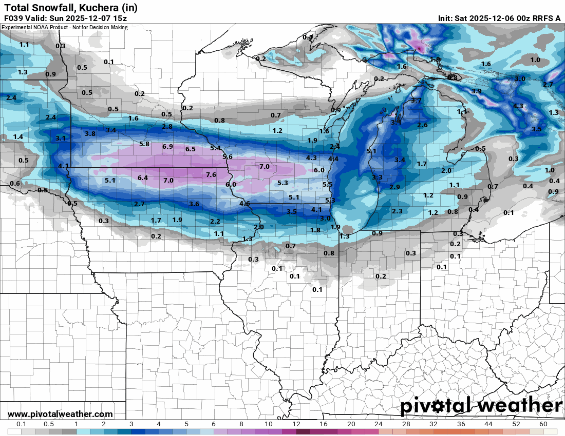
hawkeye_wx replied to Chicago Storm's topic in Lakes/Ohio Valley
The RRFS from 00z to 12z.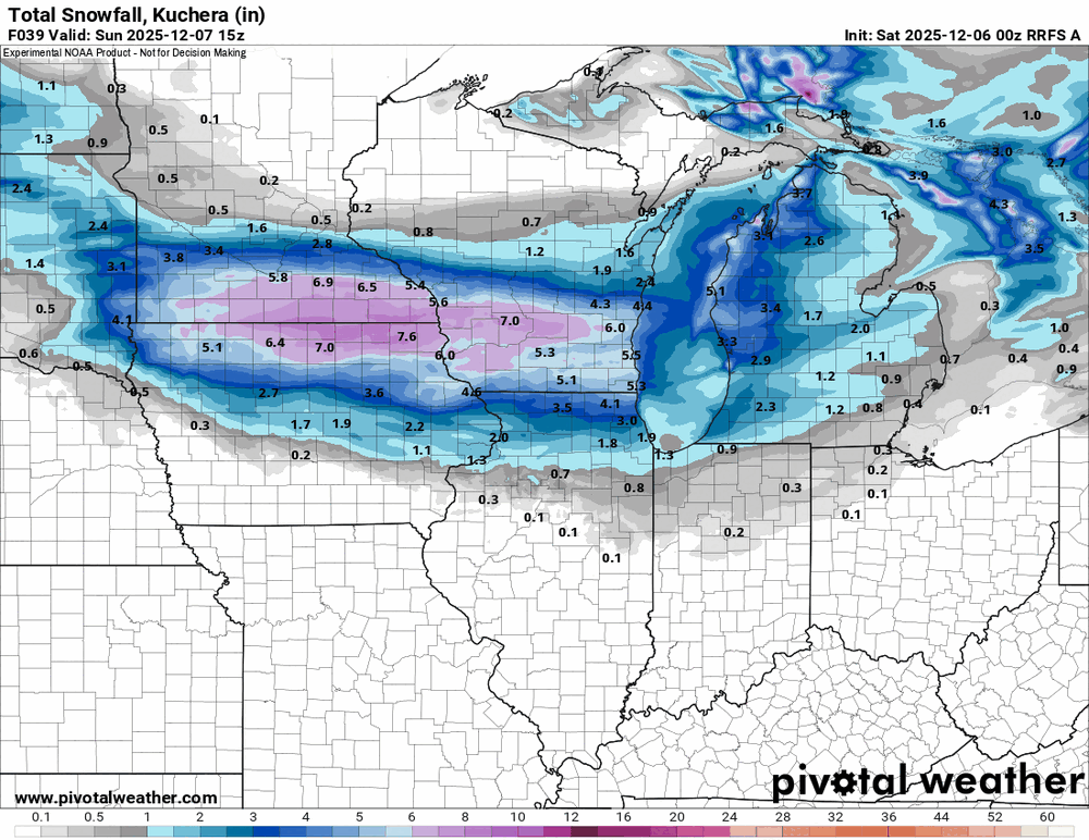
-
Dec 6-7th (It's not a clipper) Clipper
hawkeye_wx replied to Chicago Storm's topic in Lakes/Ohio Valley
The 00z models were north, but the overnight and morning trend has been back south. -
Winter 2025-26 Short Range Discussion
hawkeye_wx replied to SchaumburgStormer's topic in Lakes/Ohio Valley
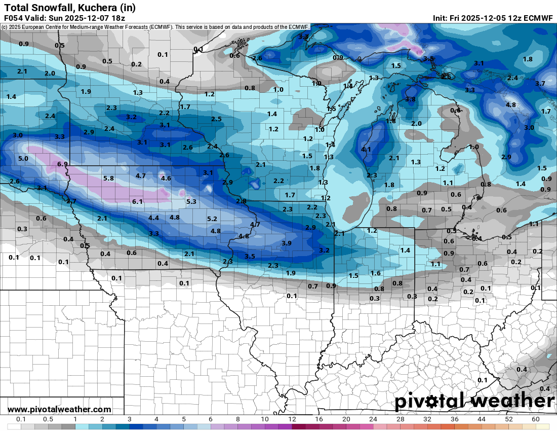
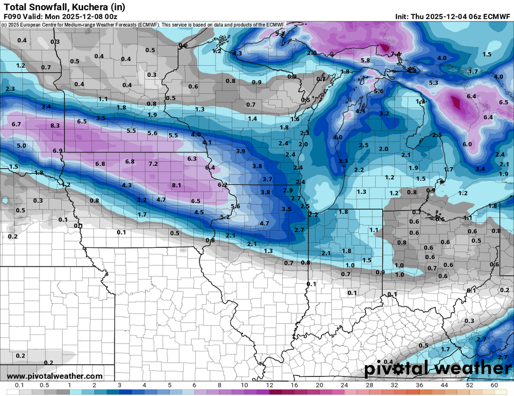
The Euro is holding steady with its snow band through Iowa. In general, the global models are farther south and the CAMs are farther north.
-
Winter 2025-26 Short Range Discussion
hawkeye_wx replied to SchaumburgStormer's topic in Lakes/Ohio Valley
The Saturday night clipper has shifted north on several models overnight. The CAMs have shifted significantly north. -
Winter 2025-26 Medium/Long Range Discussion
hawkeye_wx replied to michsnowfreak's topic in Lakes/Ohio Valley
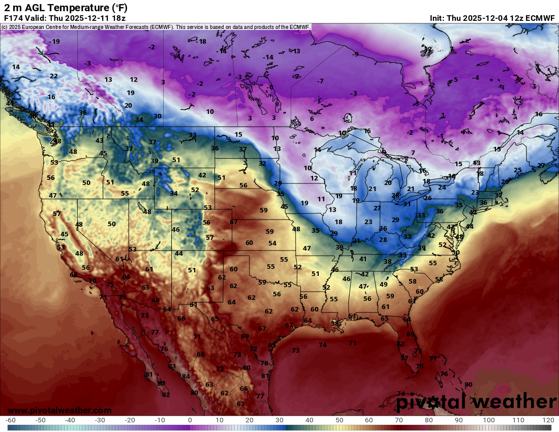
It's a very active pattern over the next couple weeks. There will be an alternating series of brief mild and cold surges. The Euro is showing quite a temp contrast a week from now between the plains and lakes.
-
Winter 2025-26 Short Range Discussion
hawkeye_wx replied to SchaumburgStormer's topic in Lakes/Ohio Valley
12z Euro is still hot with the weekend clipper for my area. This system is short-lived, though. It blows up in Siouxland and craps out after leaving Iowa.
-
Got down to -8º here, with some -teens across northern Iowa. Models are amping up the weekend clipper. The latest Euro is fairly robust.
-
Nov 28-30th Post Turkey Day Winter Storm
hawkeye_wx replied to Chicago Storm's topic in Lakes/Ohio Valley
My total is 11.0". This storm had a lot of good qualities. One negative is it was mostly light to moderate snow, with only a couple brief bursts of heavy rates, which is why I was not able to get to a foot.