hawkeye_wx
-
Posts
6,663 -
Joined
-
Last visited
Content Type
Profiles
Blogs
Forums
American Weather
Media Demo
Store
Gallery
Everything posted by hawkeye_wx
-
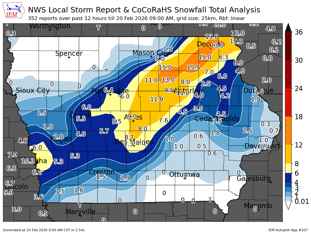
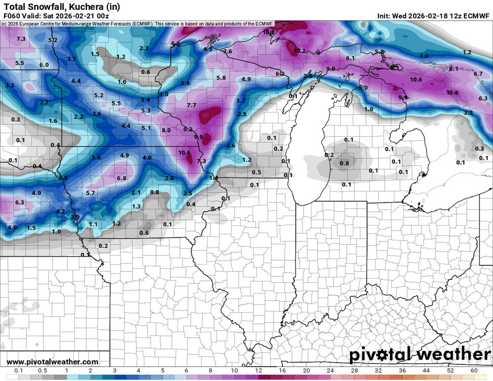
Up to 10" fell under that stationary heavy band in far se MN.
-

Winter 2025-26 Medium/Long Range Discussion
hawkeye_wx replied to michsnowfreak's topic in Lakes/Ohio Valley
It's looking much more active in March.
-
I'm still waiting for the 1000-year storm that drops 12" in my yard. That would be peak crazy.
-
"Don’t do it" 2026 Blizzard obs, updates and pictures.
hawkeye_wx replied to Ginx snewx's topic in New England
38" in Providence is insane. I've lived in eastern Iowa for 50 years and not once have I ever measured 12". -
A band of heavy snow early this morning (I was asleep) dropped 2.2" of snow here. 0.59" of rain fell before the switch. The main band over-performed to my nw.

-
Winter 2025-26 Short Range Discussion
hawkeye_wx replied to SchaumburgStormer's topic in Lakes/Ohio Valley
12z Euro has jumped back nw quite a bit. It has really amped up through Iowa, although it's almost all nw of me.
-
Winter 2025-26 Short Range Discussion
hawkeye_wx replied to SchaumburgStormer's topic in Lakes/Ohio Valley
Models continue to sag southeast with the snow event.
-
12z Euro has a potent snow event for a few Thursday night. I could see some flakes if it tracks far enough southeast.
-
We have hit 70º in Cedar Rapids.
-
Winter 2025-26 Medium/Long Range Discussion
hawkeye_wx replied to michsnowfreak's topic in Lakes/Ohio Valley
Multi-day mid-month blowtorch on tonight's GFS. It's not good to get that kind of stuff in February, so I hope it is overdoing the warmth. -
I didn't even know it was supposed to snow. I got 1.5 inches of 25:1 fluff. Sadly, this is my biggest snow event since December 13th.
-
Got yet another dusting this afternoon, this time 0.4".
-
Up to 18 inches of snow fell on coastal North Carolina. I've never measured 12.
-
Winter 2025-26 Medium/Long Range Discussion
hawkeye_wx replied to michsnowfreak's topic in Lakes/Ohio Valley
We are at least seeing the western ridge finally breaking down on the ensembles toward mid month. That is a very necessary first step. -
I'm ready for thunderstorm season.
-
Winter 2025-26 Medium/Long Range Discussion
hawkeye_wx replied to michsnowfreak's topic in Lakes/Ohio Valley
The Canadian has the storm, too.
-
Winter 2025-26 Medium/Long Range Discussion
hawkeye_wx replied to michsnowfreak's topic in Lakes/Ohio Valley
Not much in the pipeline for Iowa. -
Winter 2025-26 Short Range Discussion
hawkeye_wx replied to SchaumburgStormer's topic in Lakes/Ohio Valley
We just got a burst of heavy snow that dropped 0.5", but the temp is 33º so it's a wet snow. However, a new squall just hit with very strong wind and near white-out conditions. It should be brief, though. -
Winter 2025-26 Short Range Discussion
hawkeye_wx replied to SchaumburgStormer's topic in Lakes/Ohio Valley
We only have 0.5-1.0" on the ground. -
Winter 2025-26 Short Range Discussion
hawkeye_wx replied to SchaumburgStormer's topic in Lakes/Ohio Valley
Wind is gusting to 60-70 mph in wc IA and ec NE. DVN has issued a blizzard warning for my area. I'm not sure we'll get enough snow to justify that. -
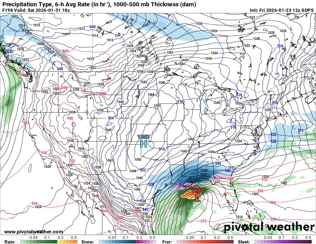
1/24-1/25 Major Winter Storm - S. IL, IN, and OH
hawkeye_wx replied to A-L-E-K's topic in Lakes/Ohio Valley
UK backed off a bit, but it's still north. -
Winter 2025-26 Short Range Discussion
hawkeye_wx replied to SchaumburgStormer's topic in Lakes/Ohio Valley
Meanwhile, a few miles to your south we got a couple tenths at first, but, even though radar suggested good snow for the last couple hours, it stopped snowing completely. The southern edge snow must be drying up as it falls. -
Winter 2025-26 Medium/Long Range Discussion
hawkeye_wx replied to michsnowfreak's topic in Lakes/Ohio Valley
UK is way north, even getting snow into Iowa.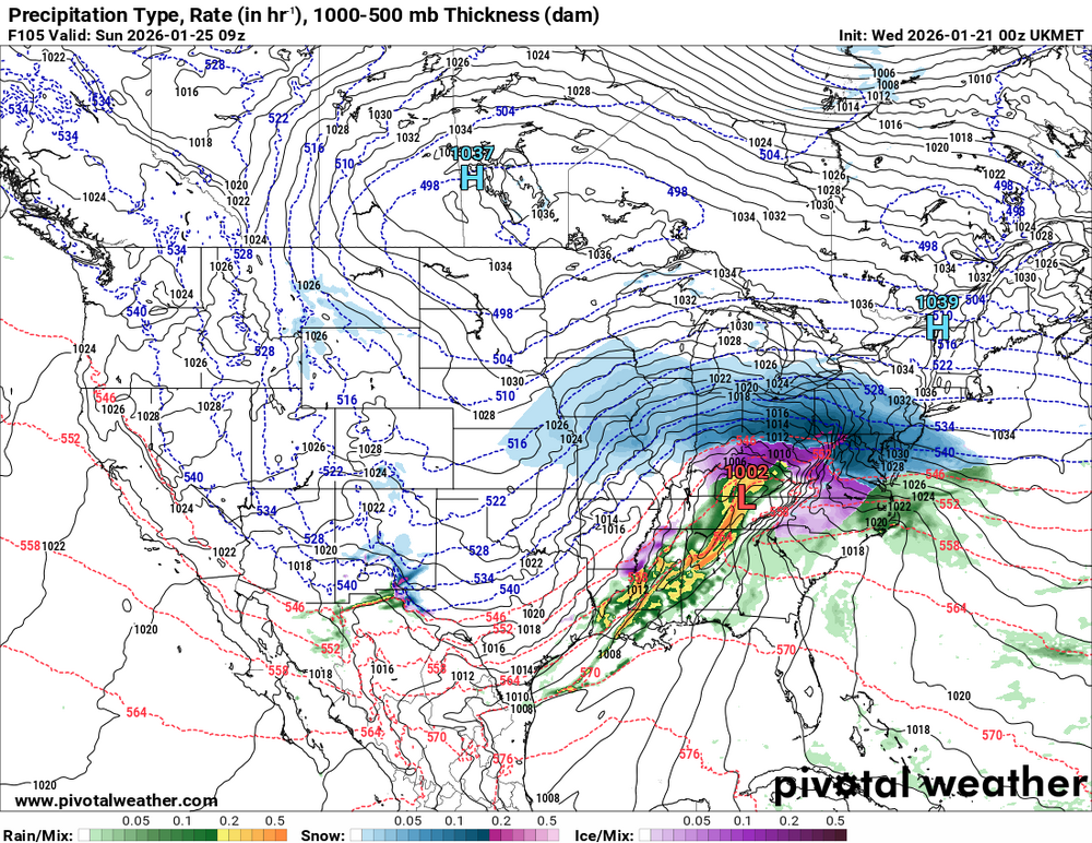
-
It appears the Bears game Sunday night, while cold, may be perfectly timed to have relatively low wind.
-
Kamchatka would be an interesting place to live. In addition to the extreme weather, it is also one of the most volcanically active places on Earth.