hawkeye_wx
-
Posts
6,652 -
Joined
-
Last visited
Content Type
Profiles
Blogs
Forums
American Weather
Media Demo
Store
Gallery
Everything posted by hawkeye_wx
-
There are no flood watches out, yet, but the CAMs are all dumping several inches of rain across parts of the se IA, n IL, ne MO area.
-
Despite a good-looking setup for eastern Iowa Wednesday into Wednesday night, all of the morning CAMs show almost all the storms forming northeast, east and south of this area.
-
On the visible satellite loop it looks like the remnant low of a tropical depression is lifting northward through eastern Iowa. The rain bands are very efficient. I got another 1.79" of rain overnight through this morning. The defo zone/pivot point of the meso low passed just west of me and produced a band of 3-4" of rain across that area. There was no thunder this morning, just tropical-style heavy rain. After getting only 1.90" of rain in May, I have already received 3.23" in the first week of June. The soil has been thoroughly replenished and the garden is thriving.
-
I hate when models back off as an event approaches. First, it was Friday (yesterday) that totally crapped out for this area. Now, the widespread 1-2" Sunday and Monday has been reduced to scattered showers, with more isolated heavy downpours. Some spots may get an inch, but others may get very little. Most of the rain on Monday has been shifted east.
-
I was fortunate to get 0.94" overnight and this morning because, overall, this disturbance did not drop the widespread 1-3" some models were advertising a day or two ago. Areas from Iowa City east and south got almost nothing. There was also zero lightning/thunder with this rain. It had also looked like Friday night would be a good storm/rain event across the area, but now that appears to be gone south, so there are some spots in ec/se Iowa that will get nothing from both nights.
-
The lawns here are very noticeably browning. However, all the ensembles are spitting out an average of 2.5+" of rain over the next two weeks, which should hold off any drought for a while.
-
The low dews are leading to spectacular mornings and evenings. While it feels great, no humidity means no rain. This is the second time in five weeks we've gone two weeks without rain.
-
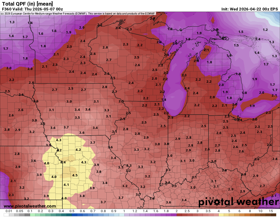
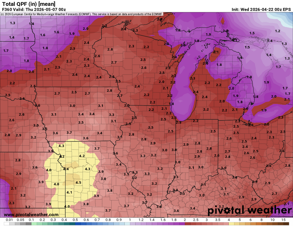
There is definitely some hope on the horizon. The pattern switches to wetter Friday. It feels like an eternity since we've had a thunderstorm. EPS mean
-
A super-dry blocking pattern in the middle of peak storm season sucks.
-
We're going into peak severe season and it's going to be snoozeville for at least the next two weeks.
-
The CAMs were wrong about everything getting stuck in Missouri and nothing getting up here. There were no strong storms around here, so in that regard the weekend was a dud. However, another round of solid rain dropped 0.64" in my yard overnight. Four decent rounds of rain through the weekend added up to 1.86". The rest of the month is looking drier and fairly boring again.
-
The Friday-Monday warmth has been underwhelming. DVN had every day in the 85-87º range, but we've come up a few to several degrees short each day. Today's it's only in the mid 70s.
-
Got another 0.47" overnight into this morning, so at least we are getting something from each round. My weekend total is 1.22". Models are still suggesting almost everything will be down in Missouri later today.
-
Models are really crapping this line out as it moves into eastern Iowa later tonight. Models are also driving tonight's line well south through Missouri, which then leads to everything on Monday developing and staying down there. This might end up being a big dud of a weekend for areas around here.
-
About 0.43" of rain here overnight. It was nice to hear thunder and rain on the roof again.
-
The dry period has been nice after weeks of rain, but after 2+ weeks of nothing we need rain again. Fortunately, we should get it this weekend into early next week.
-
Cedar Rapids got down to 31º this morning. The personal stations closest to my home also dropped to 31 or 32º, although then clouds moved in and the temp quickly rose. There was no ice in my bird bath at 7am.
-
I picked up 0.48" from the solid rain shield this morning. My April total is 7.19".
-
We got two lines of storms last night, one out ahead of the main line and then the weakening main line (although I got most of the rain from the main line). Together, I got 1.02" of rain. A band just west and north got up to 2". Totals dropped off quickly east and south of CR. My April total is up to 6.71".
-
It's nice we are getting several days of dry weather, but it is not going to last.
-
We got nothing over here. The first cells developed east of CR, then the frontal line was broken into mostly little garden-variety cells, which mostly went around me. I only got 0.13" of rain.
-
Only 0.17" here from the broken line of storms last evening. My April total is 5.56".
-
Another 0.45" this morning boosted my April total to 5.39". This is the most rain I've received in the first half of April in the last twenty years. Only four years in that period have full-month April totals higher than this year's first half.
-
The environment is now quite wet. I got another 0.83" overnight, boosting my April total to nearly 5 inches.
-
I was just awaken by another good cell at the front end of the LLJ convection. We got some small hail, wind, and very heavy rain, but nothing severe.