hawkeye_wx
-
Posts
6,658 -
Joined
-
Last visited
Content Type
Profiles
Blogs
Forums
American Weather
Media Demo
Store
Gallery
Everything posted by hawkeye_wx
-

Winter 2025-26 Short Range Discussion
hawkeye_wx replied to SchaumburgStormer's topic in Lakes/Ohio Valley
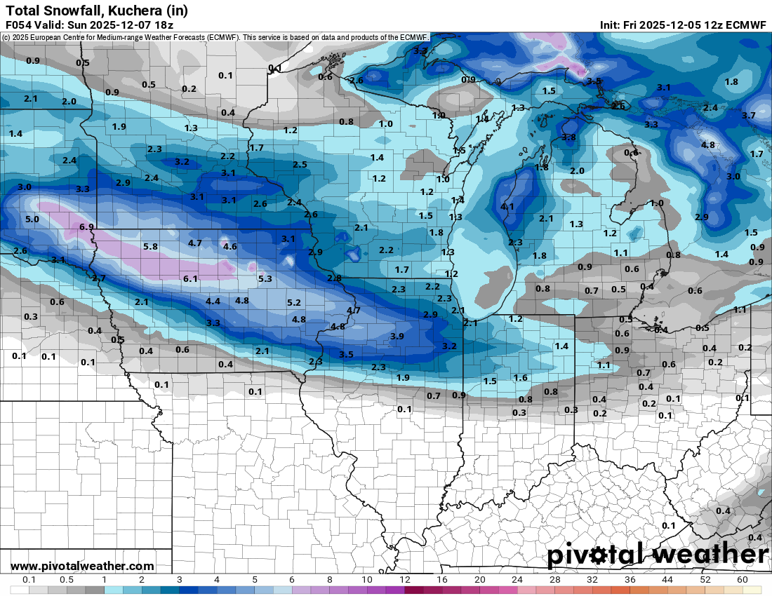
The Euro is holding steady with its snow band through Iowa. In general, the global models are farther south and the CAMs are farther north.
-
Winter 2025-26 Short Range Discussion
hawkeye_wx replied to SchaumburgStormer's topic in Lakes/Ohio Valley
The Saturday night clipper has shifted north on several models overnight. The CAMs have shifted significantly north. -
Winter 2025-26 Medium/Long Range Discussion
hawkeye_wx replied to michsnowfreak's topic in Lakes/Ohio Valley
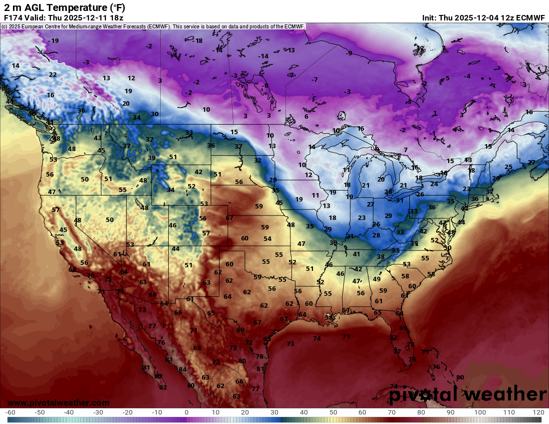
It's a very active pattern over the next couple weeks. There will be an alternating series of brief mild and cold surges. The Euro is showing quite a temp contrast a week from now between the plains and lakes.
-
Winter 2025-26 Short Range Discussion
hawkeye_wx replied to SchaumburgStormer's topic in Lakes/Ohio Valley
12z Euro is still hot with the weekend clipper for my area. This system is short-lived, though. It blows up in Siouxland and craps out after leaving Iowa.
-
Got down to -8º here, with some -teens across northern Iowa. Models are amping up the weekend clipper. The latest Euro is fairly robust.
-
Nov 28-30th Post Turkey Day Winter Storm
hawkeye_wx replied to Chicago Storm's topic in Lakes/Ohio Valley
My total is 11.0". This storm had a lot of good qualities. One negative is it was mostly light to moderate snow, with only a couple brief bursts of heavy rates, which is why I was not able to get to a foot. -
Nov 28-30th Post Turkey Day Winter Storm
hawkeye_wx replied to Chicago Storm's topic in Lakes/Ohio Valley
I have 10.9 inches. Maybe I could squeeze another 0.1 out of the last light band. -
Nov 28-30th Post Turkey Day Winter Storm
hawkeye_wx replied to Chicago Storm's topic in Lakes/Ohio Valley
Looking at my records that go back to 2007, I had never even come close to getting double-digit snow in November, until this year. -
Nov 28-30th Post Turkey Day Winter Storm
hawkeye_wx replied to Chicago Storm's topic in Lakes/Ohio Valley
Yeah, but that stuff will be very light and gradually lift north as it moves east. The latest CAMs have about another inch falling here over the next four hours. -
Nov 28-30th Post Turkey Day Winter Storm
hawkeye_wx replied to Chicago Storm's topic in Lakes/Ohio Valley
The nice, fluffy flakes from the recent heavy pocket boosted my total to 10.2 inches. Unfortunately, that was it for the good snow, so once again I will not get a 12" storm. -
Nov 28-30th Post Turkey Day Winter Storm
hawkeye_wx replied to Chicago Storm's topic in Lakes/Ohio Valley
A pocket of yellow just popped over CR, which should help get me to 10". Large flakes are dumping. -
Nov 28-30th Post Turkey Day Winter Storm
hawkeye_wx replied to Chicago Storm's topic in Lakes/Ohio Valley
I just measured 8.4 inches. The final batch of good snow is moving through now. -
Nov 28-30th Post Turkey Day Winter Storm
hawkeye_wx replied to Chicago Storm's topic in Lakes/Ohio Valley
Just measured 7.1" in my yard. The heavier snow ahead of the low has moved in. The flakes are still small, but they are dense. -
Nov 28-30th Post Turkey Day Winter Storm
hawkeye_wx replied to Chicago Storm's topic in Lakes/Ohio Valley
Snow accumulation has been slow for much of the morning due to light rates and poor flake quality. The best snow is just now getting in here ahead of the low. Reports around CR/IC say about 7", which is probably what I have so far. I had 5.7" a couple+ hours ago. -
Nov 28-30th Post Turkey Day Winter Storm
hawkeye_wx replied to Chicago Storm's topic in Lakes/Ohio Valley
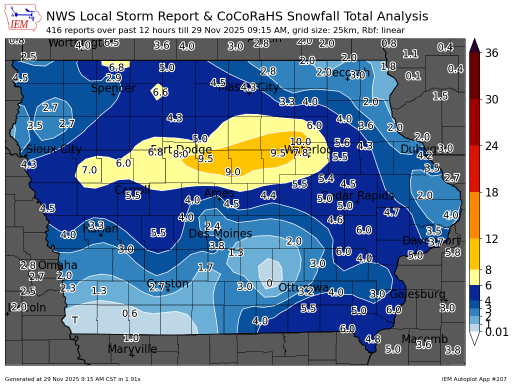
Winners and losers so far. Parts of southern Iowa are getting hosed by a persistent dry pocket that models absolutely did not show at all.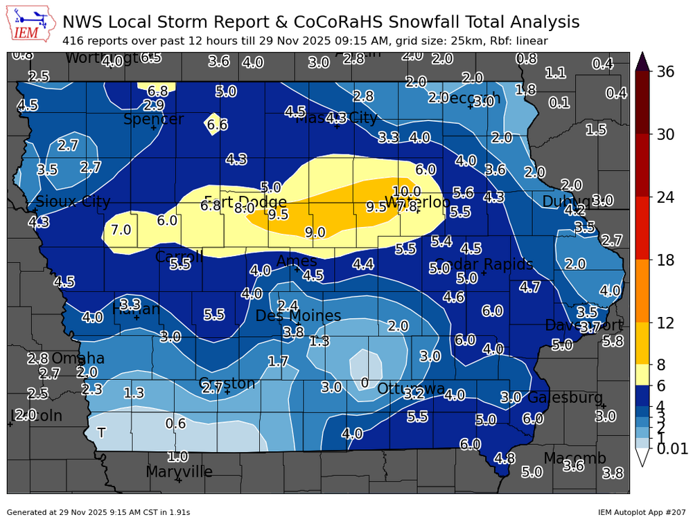
-
Nov 28-30th Post Turkey Day Winter Storm
hawkeye_wx replied to Chicago Storm's topic in Lakes/Ohio Valley
One real nice thing about this system is the wind is actually going to drop through this afternoon as the low passes by to the south and some of the best snow moves in. This should lead to an efficient ratio as the snow won't blow around. -
Nov 28-30th Post Turkey Day Winter Storm
hawkeye_wx replied to Chicago Storm's topic in Lakes/Ohio Valley
4.2" here as of 7:15am. The heaviest snow so far, with good-quality flakes, just popped over us. The winners so far have been Fort Dodge to Waterloo, where 8" has fallen. Southern Iowa has been stuck in a big dry pocket this morning, which models did not forecast. My ratio so far is 11.3 to 1, so not bad. The wind is not bad, so the snow in my backyard is very uniform, which I love. -
Nov 28-30th Post Turkey Day Winter Storm
hawkeye_wx replied to Chicago Storm's topic in Lakes/Ohio Valley
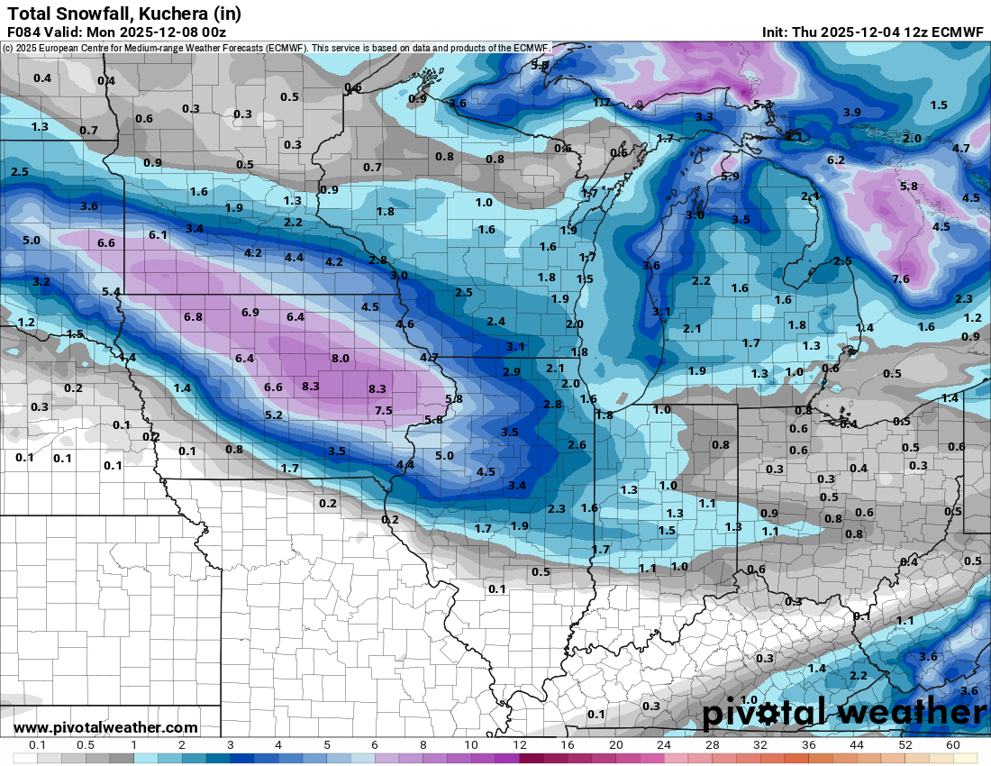
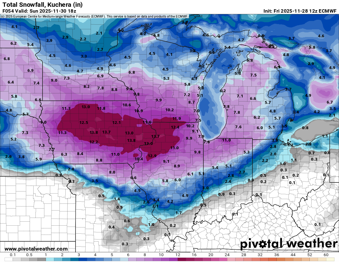
12z Euro... doesn't get much better for Iowa.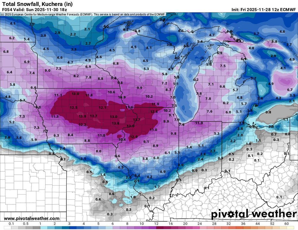
-
Nov 28-30th Post Turkey Day Winter Storm
hawkeye_wx replied to Chicago Storm's topic in Lakes/Ohio Valley
The CAMs were already holding steady with the high-end snow totals and now the lower models are coming up. This is looking like maybe a 10" floor for my area. -
Nov 28-30th Post Turkey Day Winter Storm
hawkeye_wx replied to Chicago Storm's topic in Lakes/Ohio Valley
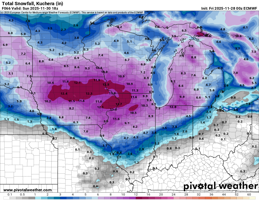
00z Euro... This is about as locked into 8+" as my area ever gets.
-
Nov 28-30th Post Turkey Day Winter Storm
hawkeye_wx replied to Chicago Storm's topic in Lakes/Ohio Valley
This evening's regionals/CAMs have not backed off at all. In fact, every model so far has inched farther north. (NAM/3kNAM/FV3/RDPS/HRRR/RRFS) -
Nov 28-30th Post Turkey Day Winter Storm
hawkeye_wx replied to Chicago Storm's topic in Lakes/Ohio Valley
Can always count on the 18z NAM/3kNAM to go extra weenie. -
Nov 28-30th Post Turkey Day Winter Storm
hawkeye_wx replied to Chicago Storm's topic in Lakes/Ohio Valley
I would, of course, love for the 18z HRRR to be correct, but it is likely too strong and juiced. It has a 1004 mb low, whereas the globals have a 1008-1012 mb low. This HRRR run would probably finish with 16+" in Cedar Rapids, which I very much doubt. Half of that is more likely. The CAMs will probably come back to earth as the start approaches. -
Nov 28-30th Post Turkey Day Winter Storm
hawkeye_wx replied to Chicago Storm's topic in Lakes/Ohio Valley
The Euro is stronger/sharper with the shortwave at 500 mb than the rest of the models. I was expecting the 12z run to fade south and weaker just a bit, but it actually ticked farther north. Here are the resulting snow maps for the south UK, middle GFS, and north Euro..gif.d232bcacfbed7617d3ea64c6d45fa873.gif)
-
Nov 28-30th Post Turkey Day Winter Storm
hawkeye_wx replied to Chicago Storm's topic in Lakes/Ohio Valley
Long-duration event, mostly light to moderate snow, with wind, the ratio in my yard is going to suck. I'm hoping for at least 6 inches.