hawkeye_wx
-
Posts
6,658 -
Joined
-
Last visited
Content Type
Profiles
Blogs
Forums
American Weather
Media Demo
Store
Gallery
Everything posted by hawkeye_wx
-
It's nice we are getting several days of dry weather, but it is not going to last.
-
We got nothing over here. The first cells developed east of CR, then the frontal line was broken into mostly little garden-variety cells, which mostly went around me. I only got 0.13" of rain.
-
Only 0.17" here from the broken line of storms last evening. My April total is 5.56".
-
Another 0.45" this morning boosted my April total to 5.39". This is the most rain I've received in the first half of April in the last twenty years. Only four years in that period have full-month April totals higher than this year's first half.
-
The environment is now quite wet. I got another 0.83" overnight, boosting my April total to nearly 5 inches.
-
I was just awaken by another good cell at the front end of the LLJ convection. We got some small hail, wind, and very heavy rain, but nothing severe.
-
88 mph gust at the Dubuque airport.
-
The cell that just moved through Cedar Rapids didn't look super potent, but still dropped a few pieces of hail up to 0.75" in my yard.
-
We are well inside the tornado watch, but models are mostly keeping the storms north of Cedar Rapids.
-
Another day, another soaker. I picked up 0.57" of rain this afternoon/evening. More rain is coming as early as Monday night, but especially Tuesday/Wednesday, then a good event Friday night. Wet, wet, wet.
-
1.23" in my gauge this morning... 3.53" in April so far.
-
There are only a few snow reports trickling in so far. The highest is 5.5".
-
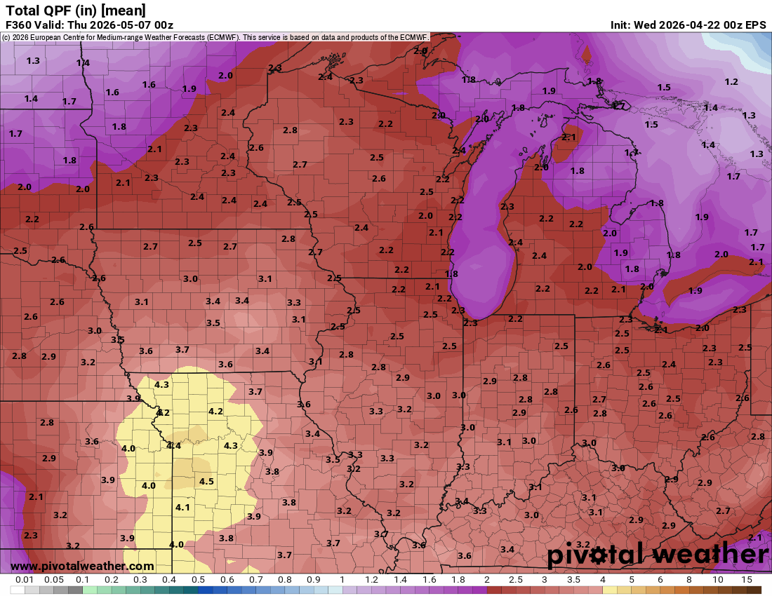
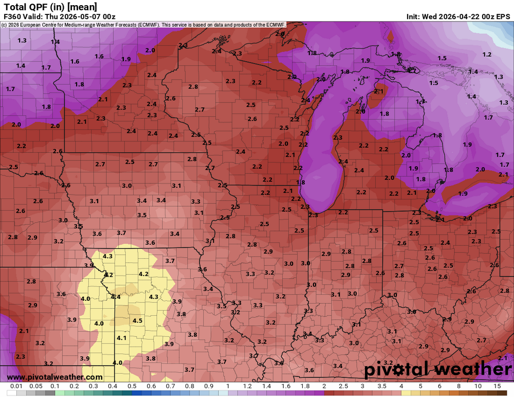
The ensembles continue to show 2.5-3" of rain across the area over the next two weeks. That's great as we head into the warm season, but it's a problem for the construction crew that has to re-grade the new stormwater wetland next to my house and then plant seed.
-
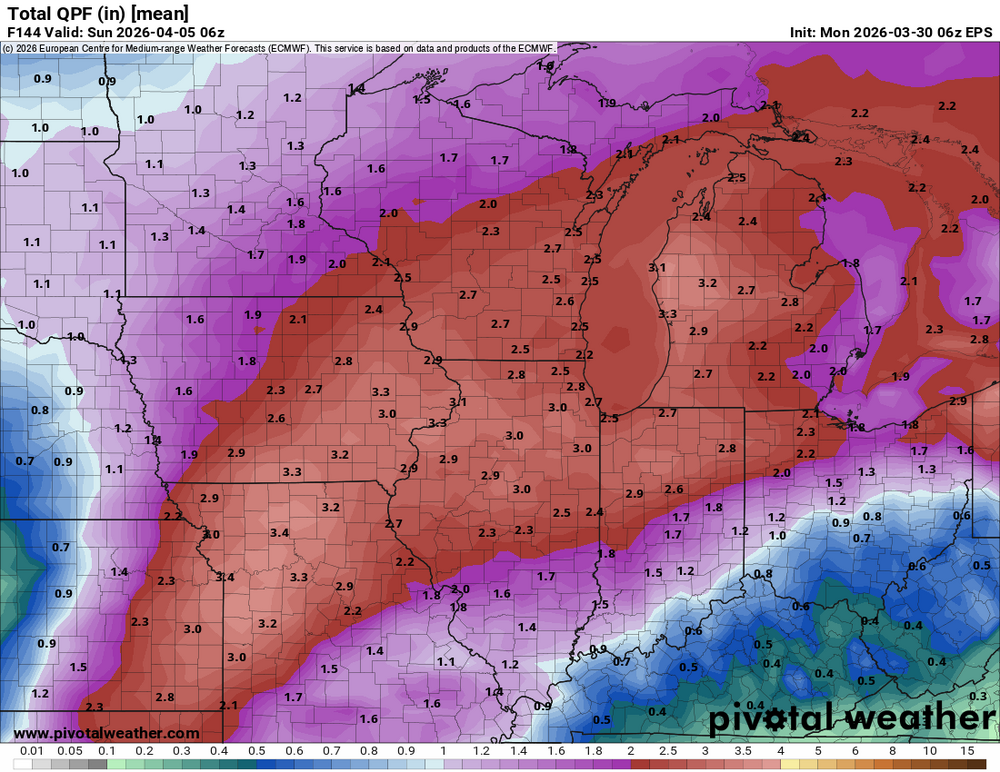
My area did not quite get the 3+" of rain shown on the ensembles earlier in the week, but I'm happy with 2.30". Now we get to deal with four days of cold before the warmth and action returns.
-
My event total rain is 1.73".
-
The line looked potent, and was severe-warned, as it moved through Cedar Rapids, but it was bit of a dud.
-
Got 0.30" of rain overnight. A couple stronger cells with vivid lightning passed just barely north, got a good view.
-
A much-needed widespread soaker over the next week.
-
The 5-minute obs show that Cedar Rapids did hit 90º today. CR's previous record first 90º day was April 10th, 1930. We smashed it by three weeks. Update: Despite the intra-hour measurements, the official high is showing as 89º as we didn't quite hit 90º. The intra-hour measurements are apparently rounded up.
-
We've hit 89º in Cedar Rapids. A couple days ago I think DVN had 72º today. Since then they went to 75º, 80º last night, and 85º this morning.
-
Cedar Rapids is 88º. Iowa City is 90º.
-
Cedar Rapids is up to 83º at 2pm. Des Moines is 89º.
-
Cedar Rapids has risen from 50º to 74º in four hours. We are now a few degrees ahead of the HRRR, which is forecasting 86º in a few hours. It is already 82º in Des Moines.
-
The temp has soared way past the NWS forecast. Last night DVN said 55º, then this morning 60º, then at midday 63º. It is now 68º and still rising.
-
I took ~90 measurements in a grid across my backyard and came up with 3.0", which seems about right considering the drifts and scoured areas. The gauge caught 0.40", which means the ratio is terrible, as it always is when the wind is strong. The kuchera map predicted a ratio well above 10. This stuff was a major pain to clean up. It's dense, with a layer of either wet snow or ice on the bottom.