

hawkeye_wx
-
Posts
6,658 -
Joined
-
Last visited
Content Type
Profiles
Blogs
Forums
American Weather
Media Demo
Store
Gallery
Everything posted by hawkeye_wx
-

Nov 28-30th Post Turkey Day Winter Storm
hawkeye_wx replied to Chicago Storm's topic in Lakes/Ohio Valley
The shift back south is real across all models. Probably cut the totals by 30%, though.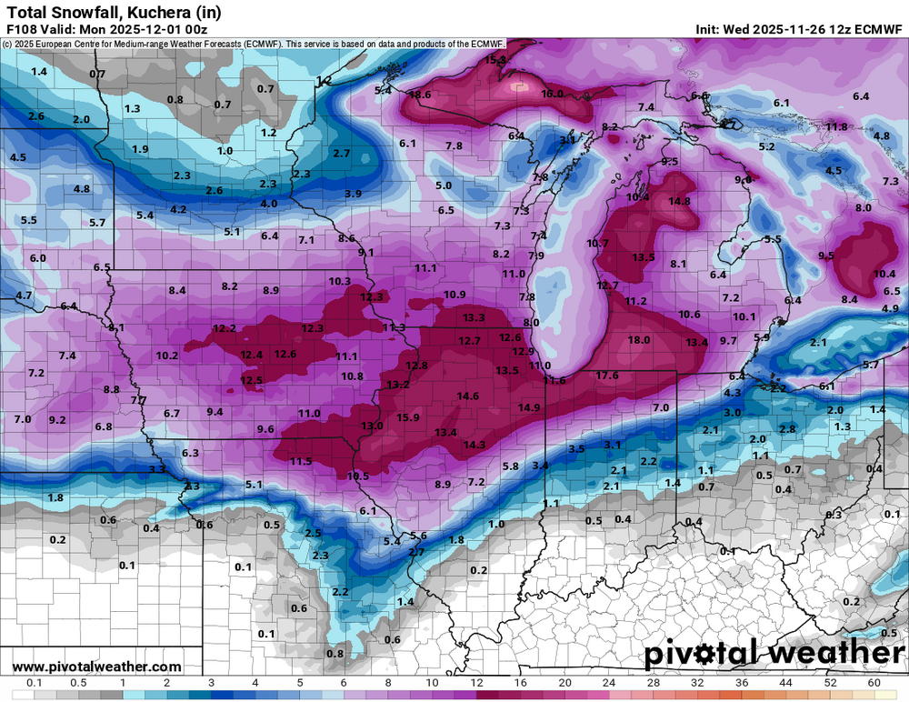
-
Nov 28-30th Post Turkey Day Winter Storm
hawkeye_wx replied to Chicago Storm's topic in Lakes/Ohio Valley
I'm sitting pretty good this morning, but this is still four days away, which is a long time in the model world. -
Nov 28-30th Post Turkey Day Winter Storm
hawkeye_wx replied to Chicago Storm's topic in Lakes/Ohio Valley
Some models had been dumping a bunch of the energy into the sw US and cutting it off, but now they are all trending toward ejecting it into the midwest this weekend. The Friday night snow is looking a bit lighter, but now a stronger low blows up the snow across Iowa Saturday into Saturday night. As long as it doesn't trend any farther north, which every model this morning has done, I should be good. -
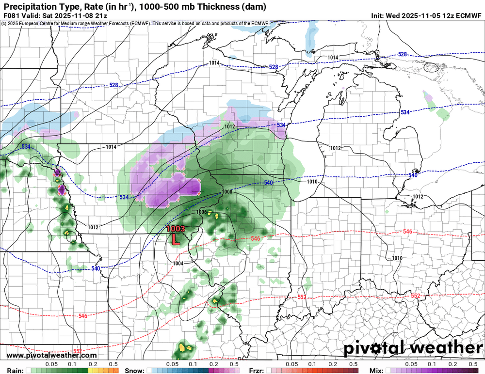
Well, we are back to zero because the Euro just came in way different at the end of the week. Last night the Euro looked like the GFS, but now it has suddenly pulled all the energy back into the western US and pulls a bunch of warm air up into Iowa so we get rain.
-
Meanwhile, the Canadian is much weaker and drier with this system, plus it is dry Sunday-Tuesday while the GFS has two more significant events.
-
The ICON and GFS are coming in hot this morning for the end-of-week snow event. Both have potential for 6+" across Iowa and Illinois if the rates are heavy enough to counter the warm ground.
-
Fall 2025 Medium/Long Range Discussion
hawkeye_wx replied to Chicago Storm's topic in Lakes/Ohio Valley
There's plenty of action in the distance. The snow may all end up in the Dakotas and Minnesota, but it's at least some good stuff to track. I certainly won't complain if we get some good showers and storms. -
0.48" here, on the high end of the model range. Up to 0.90" fell on the northeast edge of the city. It came with some decent lightning/thunder.
-
The big late-week system is now gone from the GFS. The southwest energy has been slowing while the energy moving along the Canada border has been speeding up and digging a bit more, so the wet cutter gets squashed.
-
This would be nice, but some models are hinting at suppression. The AI Euro drops little to nothing from north of I-80.
-
By far the best northern lights I've ever seen.
-
11/8-11/10 First Snow and Lake Effect Event
hawkeye_wx replied to Geoboy645's topic in Lakes/Ohio Valley
The warmer models were correct for my area. I did not see a single flake. -
0.56" of rain here.
-
11/8-11/10 First Snow and Lake Effect Event
hawkeye_wx replied to Geoboy645's topic in Lakes/Ohio Valley
Far nw Iowa got up to 4" of snow this morning. It is accumulating a little in Ames. It is too warm here as the precip is arriving at peak heating. -
The model trend is for a weaker system as it moves across Iowa. There is no guarantee I'll see any flakes.
-
Some models had already been teasing some snow mixing in across Iowa. Now the Euro has finally joined them.
-
There used to be a 60-ft tall red maple in my neighbor's backyard. It was too big for our small lots, but it was a beautiful, brilliant red color in fall. The 2020 derecho destroyed it. There is a still a young Fall Fiesta sugar maple in the front yard. So far, the tree has not had good color, although this year it is definitely better.
-
The GFS is the only model showing any real snow this weekend around here, but all models show the first big push of arctic air. It looks brief, however.
-
Major Hurricane Melissa - 892mb - 185mph Jamaica landfall
hawkeye_wx replied to GaWx's topic in Tropical Headquarters
Josh has a new post https://x.com/iCyclone/status/1983730201860206979 I can't figure out how to embed an X post. -
0.43" here overnight. My October rain total is 1.58", which is my driest October since 2011.
-
Major Hurricane Melissa - 892mb - 185mph Jamaica landfall
hawkeye_wx replied to GaWx's topic in Tropical Headquarters
So the NHC is going to call it 892 mb at landfall? I'm very skeptical. I understand the 892 mb from recon is their final real data before landfall, but the satellite presentation was clearly better a couple hours ago when recon got that measurement. -
Major Hurricane Melissa - 892mb - 185mph Jamaica landfall
hawkeye_wx replied to GaWx's topic in Tropical Headquarters
Given some slight degradation on satellite, I don't think this will be still be sub-900 when the center of the eye crosses the coast. -
Major Hurricane Melissa - 892mb - 185mph Jamaica landfall
hawkeye_wx replied to GaWx's topic in Tropical Headquarters
It had looked like he'd hit the center, but the left hook may leave him just getting into the eastern edge of the eye. -
Major Hurricane Melissa - 892mb - 185mph Jamaica landfall
hawkeye_wx replied to GaWx's topic in Tropical Headquarters
The eye is actually still hooking left as it moves into the coast. The dead center could end up just a hair west of Josh. -
Major Hurricane Melissa - 892mb - 185mph Jamaica landfall
hawkeye_wx replied to GaWx's topic in Tropical Headquarters
Josh doesn't do live streams. He should have good video afterward.


