-
Posts
4,732 -
Joined
-
Last visited
Content Type
Profiles
Blogs
Forums
American Weather
Media Demo
Store
Gallery
Everything posted by Windspeed
-

December 2020 Medium/Long Term Pattern Discussion.
Windspeed replied to John1122's topic in Tennessee Valley
This is a pretty big deal and thought it should go here. -

Wild Speculation for Winter 20 -21
Windspeed replied to Holston_River_Rambler's topic in Tennessee Valley
Yeah you can always live vicariously through New Englanders. [emoji25] -
Worth pointing out that Central America was hit very hard and we shouldn't forget that. Though Louisiana was certainly beat up this season, the US still has the resources to mitigate and assist our fellow citizens. We shouldn't forget them either. That being said, Guatemala, Honduras and Nicaragua and the SW Caribbean were already struggling. Millions of of people are suffering there economically. Now we have a humanitarian crisis as many localized regions are currently devastated. This was a horrific hurricane season.
-
I think last Tuesday's outlook was a wrap on the 2020 season folks! ZCZC MIATWOAT ALL TTAA00 KNHC DDHHMM Special Tropical Weather Outlook NWS National Hurricane Center Miami FL 955 AM EST Tue Dec 1 2020 For the North Atlantic...Caribbean Sea and the Gulf of Mexico: 1. A gale-force, non-tropical low pressure system is centered between the Madeira Islands and the Azores. This system has become less organized during the past 24 hours, and environmental conditions are expected to become less conducive for development as the system moves southwestward during the next day or two. Although subtropical development is now unlikely, this system will continue to produce strong winds and locally heavy rains in the Madeira Islands and the Azores through Wednesday. Additional information on this system can be found in High Seas Forecasts issued by Meteo France. This will be the last Special Tropical Weather Outlook issued on this system. Regularly scheduled Tropical Weather Outlooks will resume on June 1, 2021, while Special Tropical Weather Outlooks will be issued as necessary during the off-season. * Formation chance through 48 hours...low...10 percent. * Formation chance through 5 days...low...10 percent. High Seas Forecasts issued by Meteo France can be found under WMO header FQNT50 LFPW. Forecaster Beven
-
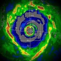
It's literally insane. Gati came out of nowhere, was not modeled by any guidance near this intensity. There is no historical record of a Cat 3 landall in Somalia, though I suspect in years where upwelling off of the NE Somaliaan coast, OHC at near surface might be warm enough on occasion. Still, generally too arid an environment to support such intensities. Takes more than SST support. Just a really phenomenal cyclone. Gati does appear to be weakening into landfall. Unfortunately it may be too late for weakening to mitigate impacts to higher population center as these folks have rarely ever experienced hurricane force impacts to a weak infrastructure.
-
ACE is now at 170. Probably going to hit 180 if Iota rapidly deepens into a Cat 4. The Greek list has been a season in of itself.
-
Don't shoot the messenger but, well, yuck.
- 168 replies
-
- 2
-

-
- leaves changing
- temperatures
-
(and 2 more)
Tagged with:
-
Yes. Also a 67 mph gust now reported near Dundee in Polk County.
-
ACE is at 163 for the season. If 98L, possible future Iota develops into a hurricane in the Western Caribbean, that should get us to 170. A little bit of irony in that. Several preseason forecasts for a hyperactive season, including CSU/RAMSDIS had 170 ACE, including myself early in the thread. Thought it unwise to forecast higher as it takes a lot of luck and a number of long-tracking high end intense hurricanes. Of course this season being dominated by near-to-land rapid intensification and weaker TCs, it's still pretty phenomenal we made it to 170. Thank the late season burst of hurricanes for powering ACE upwards. I had actually revised my number down a lot back in early October to around 140. Definitely busted on that...lol.
-
Downgraded. Punta Gorda just had a 69 mph wind gust.
-
I see what you did there.
-

Tropical Storm Theta - MSW: 65mph... ENE at 8 mph... 989mb
Windspeed replied to yoda's topic in Tropical Headquarters
Text book subtropical storm... -
97L...
-
Eta's core convection has improved significantly this evening. Dare I say looks like a hurricane is back on the menu for tomorrow. It will not remain one into the NGOM however.
-
Severe weather outbreaks.
-
Convection slowly increasing around the center.
-
This landslide in Guatemala took out an estimated 75 homes.
-
Invest 97L looks close to getting named. The bottom half of the surface circulation looks to be contracting, aligning under the robust mid-level circulation and convection. This looks like an STC now.
-
Seems reasonable. Interestingly the 06z HWRF has come in much weaker and disorganized versus all the previous runs that wanted Eta to experience another round of robust intensification. It figures. lol... We'll see if the NHC begins to back off reintensification to a hurricane on the next advisory. I doubt it based on one factor of guidance. As for track, it still makes more sense that the vortex either eventually makes landfall along the Panhandle to Big Bend area or gets sheared off and degenerates into remnant low along the NGOM coast by the incoming CONUS trough. The 06 HWRF also does move the system more west which would subject it to a harsher environment.
-
Eta is now moving SSW. Though it looks pretty anemic thanks to very stable dry air out of the west being pulled in by the mid-to-upper trough/ULL, there is still a good stream of moisture feed out of the Caribbean on the backside. As Eta continues to dive SSW today, robust convection will likely begin to weaken the ULL due to diabetic heating. As such a small anticyclone should begin to form over Eta to further aid in divergence. Dry air may have less of an influence without the mid-level flow infringing upon Eta's vortex. If convection can ramp up this evening, it should be able to close off and shield itself somewhat from the mid-level influences of dry air and shear. This has been modeled consistently by the HWRF, which continues to want to ramp Eta back up into a hurricane. How strong a hurricane will likely depend on how far SSW the vorticity maximum can get by tonight, how long it persists there over the Gulf Loop (which is still very warm at the surface - 29ºC), and how fast the ULL can be filled by Eta's convective influences.
-
Fairly impressive structure to have crossed Cuba. It did seem to straddle between the higher terrain but the western semicircle of the low level vortex did cross over mountains. Still, the core looks intact. We'll see how this translates to strengthening today. There is still moderate shear.
-
HWRF now gets Eta down to 960 mb in the EGOM. This is likely due to Eta remaining SE of strong mid level southwesterlies for a longer duration and also over the GS loop current as well. Not sure if it will make a run at Cat 3 but such modeling does hint at how Eta could become a formidable hurricane again. That being said, there isn't enough atmospheric support or OHC in the NE GOM for it to maintain such an intensity. Beyond cooler SSTs, it would eventually succumb to shear W or WNW of Tampa.
-
Sheared? Yes. Still, not looking too shabby for a TS at the moment. Impressive bursts of lightning over the past hour. Eta is trying to find itself a hurricane again.
-
Eta still has a sheared assymetric presentation on radar.


