-
Posts
4,734 -
Joined
-
Last visited
Content Type
Profiles
Blogs
Forums
American Weather
Media Demo
Store
Gallery
Everything posted by Windspeed
-
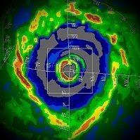
969.9 EXTRAP on that last pass.
-
132 kts at the 942 mb level! I'd absolutely go with 115 mph now.
-
NHC could definitely go with a 115 mph advisory now.
-
Big burst of lightning on latest imagery.
-
Crazy impressive for freaking October 28th. Kate in November '85 was an impressive Category 2 into the Panhandle but it was also weakening significantly at landfall.
-
Looks like SE quadrant is the strongest quadrant now due to relative storm motion. So this is definitely not a Cat 3 yet. However there will be one more pass through the SE quadrant so we'll see if it has further strengthened over the past hour.
-
Fortunately it will be hauling ass so hopefully that will mitigate surge. Yes, there still will be surge, but again, forward motion is so fast it may not have enough time to build surge inland too far or compromise levees. This looks like it will be a bad wind event however as time is going to run out before it can weaken from maximum intensity...
-
Man it's going to really be something if this reaches Cat 3 this afternoon. Nobody saw this coming.
-
Uhm...pretty strong convective towers are now presently going up in the eastern eyewall. Zeta is putting on a show.
-
For a Category 2 hurricane, which is what I expect recon to find, this is about as gorgeous a satellite presentation as your ever going to see. If that eye continues warming, this might make run at Cat 3. I don't think it will make it before landfall, but 6 hrs is plenty of timing during rapid deepening. Zeta is going to be a bad landfall if it continues strengthening all the way onto shore. No hurricane is the same, but an intensifying Cat 2 is worse than a weakening one. Winds will mix down more efficiently. I cannot get over this satellite presentation considering the SSTs. Was totally not expecting this regardless of the HWRF's hints.
-
Multiple CBs rotating around the eyeband with three distinct hot towers. Zeta appears to be intensifying. Amazing what even 26°C SSTs can fuel within a very dynamic upper atmospheric environment.
-
[emoji102]
-
Visible of Zeta's core since daybreak...
-
The Atlantic Basin has now surpassed 140.9 (96.9 climatological average for date) for the season. 150 is generally considered the benchmark for a hyperactive season. Obviously we're there based on number of storms but passing that mark also quantifies the ACE metric as well. If there ends up being another strong Caribbean hurricane as has been suggested off and on by modeling in the coming week, we'll likely eclipse that mark now. Either way it has been a very busy, even exhausting year.
-
Based on HURDAT, Zeta is now the strongest hurricane on record this far West in the Atlantic Basin for this late in the season. There appears to be some assymetric shape taking over due to strong SW flow. The system is also gaining forward motion pretty quickly. Not sure how much weakening will occur prior to landfall if any though due to fast motion. HWRF wanted to get this down to around 969 mb by landfall. We'll see...
-
I'd say this rise is temporary due to reorganization of the convective band currently wrapping the vortex that was evident on MW. Zeta's core still has 24 hours over good OHC to deepen.
-
Much colder and stronger mid-level digging trough. I think this is going to play right into modeling.
-
Even with the cold upper dynamics, I am still not buying anything lower than 970 hPa landfall. It's just really difficult for 26°C SSTs to pull that off and there may be strong mid-level flow to advect Theta-E dry air intrusion by landfall. Again, this is semantics and the real beef may be during ET transition post landfall. Yes, Zeta could go nuts the next 24 hrs, but it's probably not going to hold that intensity through landfall. That doesn't mean to downplay the post-landfall event at all since it matters not.
-
- 168 replies
-
- 1
-

-
- leaves changing
- temperatures
-
(and 2 more)
Tagged with:
-
The central GOM, NW of the Yucatán is still conducive for high lapse rates and would support a major. The trek north of that however will depend on how cold upper tropospheric jet entry is with the digging trough. I guess we'll find out just how much 26°C can muster. The hurricane will be hauling ass at that point however and starting to feel baroclinic forcing. This is going to be an impactful event well inland due to the synoptic setup regardless of official landfall intensity.
-
Could be pretty potent ET transition over land well inland. 80-90 kt low-level jet at 900 hPa. Just depends on how strong convection is on the eastern flank of the circulation to mix down gusts as it phases with the mid-level low.
-
Just going on the elongated minimal pressure obs from recon and their veer to the center point of that CDO feature. At any rate, it's looking like Zeta is going to run out of ocean surface before it can go bonkers, which is a good thing.
-
Almost looks as if there has been another vortex realignment. Though EXTRAP was rather broad around 983, they hit 982.5 within the presently strong MCS as the flight veered just E of S. Winds have not come up. We'll have to see if strong area of convection becomes the dominate vorticity maximum prior to landfall. Again, though pressure is still falling, it seems some structural reorganization may be underway. Fortunately for the Yucatán, at this time, it appears Zeta is going to run out of time for significant strengthening to take off.


