

Windspeed
-
Posts
4,741 -
Joined
-
Last visited
Content Type
Profiles
Blogs
Forums
American Weather
Media Demo
Store
Gallery
Everything posted by Windspeed
-
Since daybreak. This is going to max out pretty dang fast based on satellite trends. I'd say this is a Cat 3 and by the time recon gets there this afternoon it will be a Cat 4 at least by the time they complete their last mission pass.
-
-
Eta may very well end up the best looking hurricane in the Atlantic Basin 2020. Long way to go for continued RI through landfall and a beautiful upper atmospheric presentation evolving.
-
Eta is probably a hurricane by now. But I suspect without recon, it won't be upgraded until 4AM.
-
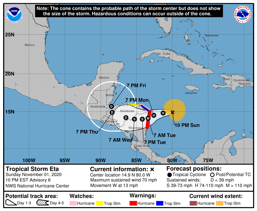
NHC now forecasting Eta to become a major hurricane. Stewart typed a novel. 000 WTNT44 KNHC 020252 TCDAT4 Tropical Storm Eta Discussion Number 6 NWS National Hurricane Center Miami FL AL292020 1000 PM EST Sun Nov 01 2020 Eta has continued to become better organized this evening, including the development of an impressive Central Dense Overcast (CDO) with cloud tops colder than -90C near the center, improved banding features in the northwestern semicircle, and the formation of a pinhole mid-level eye noted in 01/2322Z 91GHz SSMI/S microwave imagery. Water vapor imagery also indicates that the upper-level outflow pattern has continued to expand, with dual outflow channels having formed to the northeast and the southwest. Satellite intensity estimates are a consensus T3.5/55 kt from TAFB, SAB, and UW-CIMSS ADT. However, the initial intensity is set a little higher at 60 kt based on the pinhole eye feature...and this intensity estimate is probably conservative. An Air Force Reserve hurricane hunter aircraft is scheduled to investigate Eta in a few hours. Eta has slowed down but is still moving westward, or 270/11 kt. An expansive subtropical ridge that extends from the southwestern Atlantic across the Bahamas, Florida, and into the Gulf of Mexico is expected to keep Eta moving in a general westward direction through Monday morning. By Monday afternoon and evening, the portion of the ridge over the Gulf is forecast to build southward and eastward in the wake of an exiting mid-latitude trough currently moving across the eastern and southeastern United States. The increased ridging will act to force Eta west-southwestward and eventually southwestward over the next 36 hours, resulting in landfall along the northeastern coast of Nicaragua. After moving inland, steering currents are forecast to weaken significantly on days 3-5 as another trough digs southeastward out of the U.S. Plains and into the Gulf of Mexico, eroding the Gulf ridge and causing Eta to drift slowly westward across Central America. Compared to the preponderance of the the model guidance, the HWRF solution of Eta remaining just offshore over the northwestern Caribbean Sea is considered to be an outlier. The new NHC track forecast is very similar to the previous advisory track, and lies close to the simple-consensus models TVCA and GFEX, which are a little to the right of the corrected-consensus model, HCCA. Based on the new NHC track forecast, no changes are required to the existing tropical cyclone warnings and watches in effect. Eta has rapidly intensified 20 kt during the past 12 h. Given the much improved inner-core structure as noted in the SSMI/S imagery, combined with sea-surface temperatures in excess of 29 deg C, mid-level humidity values greater than 80 percent, and the already impressive outflow pattern, Eta should continue to rapidly strengthen until landfall occurs. The main question is: how much strengthening will take place? Some of the more reliable intensity guidance brings the cyclone up to 105-110 kt in 36 hours, with the HWRF model bringing Eta to near category-4 strength. The new NHC intensity forecast shows Eta as a major hurricane in 36 hours when it is expected to be located just inland over northeastern Nicaragua, but a stronger intensity is highly probable just before landfall occurs. Rapid weakening is forecast thereafter while the cyclone moves over the rugged, mountainous terrain of Nicaragua and Honduras, with Eta possibly devolving into a large, quasi-stationary Central American Gyre (CAG). Key Messages: 1. Eta is forecast to strengthen into a hurricane by early Monday morning. Additional strengthening is forecast thereafter, and Eta is expected to be a major hurricane before it reaches the northeastern coast of Nicaragua Monday night or early Tuesday, where a Hurricane Warning is in effect. A Tropical Storm Warning is in effect for a portion of the northeastern coast of Honduras. 2. Through Friday evening, heavy rainfall from Eta will lead to catastrophic, life-threatening flash flooding and river flooding across portions of Central America, along with landslides in areas of higher terrain. Flash and river flooding is also possible across Jamaica, southeast Mexico, El Salvador, southern Haiti, and the Cayman Islands. 3. A life-threatening storm surge, along with damaging waves, is expected along portions of the northeastern coast of Nicaragua near and to the north of where the center makes landfall. Water levels could reach as high as 10 to 15 feet above normal tide levels in some parts of the hurricane warning area. Preparations to protect life and property should be rushed to completion. FORECAST POSITIONS AND MAX WINDS INIT 02/0300Z 14.9N 80.0W 60 KT 70 MPH 12H 02/1200Z 14.8N 81.3W 75 KT 85 MPH 24H 03/0000Z 14.5N 82.6W 90 KT 105 MPH 36H 03/1200Z 14.1N 83.4W 100 KT 115 MPH...INLAND 48H 04/0000Z 14.0N 84.2W 60 KT 70 MPH...INLAND 60H 04/1200Z 14.0N 85.3W 45 KT 50 MPH...INLAND 72H 05/0000Z 14.2N 86.5W 30 KT 35 MPH...INLAND 96H 06/0000Z 14.9N 88.4W 25 KT 30 MPH...INLAND 120H 07/0000Z 15.7N 88.5W 25 KT 30 MPH...INLAND $$ Forecaster Stewart
-
I wouldn't read to much into if the current intensity matches the HWRF. My take away is that conditions support RI and a major that may get intense prior to landfall. That being said, it appears the system is already slowing down. If this slows down a little faster than anticipated, that could contribute to stronger intensity at landfall as well. There is a shallow shelf near the Nicaraguan and Honduras coastline but everything above that shelf is still quite warm, ~29°C. A slow moving landfall might allow it to peak as a Cat 4 then begin weakening. But with a favorable upper environment, weakening isn't a given beyond perhaps structural/ERC occurring.
-
Rainfall estimates are insane. Some localized estimates could exceed 35 inches. That is going to cause mud flows.
-
Might be a small core forming. Should have recon vortex data in about an hour.
-
 Traveling to the Philippines or the Far East even for official government business is difficult right now, much less non-essential travel.
 -
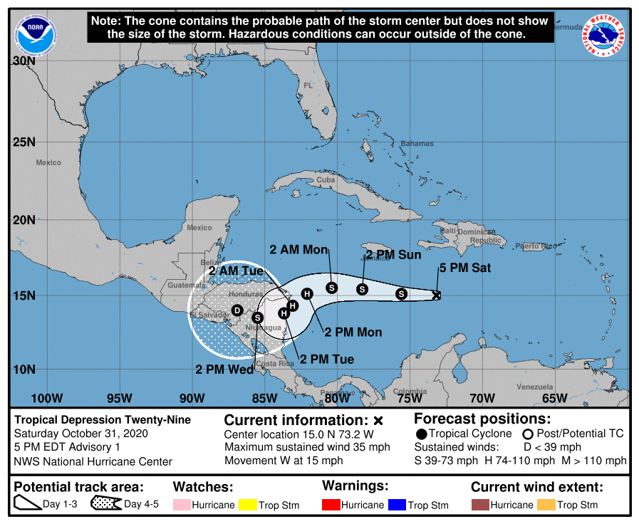
Track follows consensus more or less. I still think a stronger hurricane misses Honduras / Nicaragua to the north and the model consensus will be wrong. But they're not forecasting a strong hurricane so take my nonsense with a grain of salt. 000 WTNT44 KNHC 312050 TCDAT4 Tropical Depression Twenty-Nine Discussion Number 1 NWS National Hurricane Center Miami FL AL292020 500 PM EDT Sat Oct 31 2020 Showers and thunderstorms have continued to become better organized in association with a tropical wave which has been moving westward across the central Caribbean Sea. It was unclear this morning if the system had developed a closed low-level circulation, since scatterometers have avoided the system over the past 24 hours, but recent visible and microwave satellite images suggest that the system almost certainly now has a well-defined center. For that reason, the system is being designated as a tropical depression with 30-kt winds, based on Dvorak classifications of T2.0 from both TAFB and SAB. A low- to mid-level ridge axis that extends from the subtropical Atlantic southwestward to Cuba and the Bahamas is currently steering the depression toward the west (270 degrees) at an estimated speed of 13 kt. Model guidance is in fairly good agreement on the depression's future track for the first 48 hours or so. The cyclone is expected to continue westward for the first 36 hours and then slow down and turn west-southwestward by 48 hours as it approaches the coasts of Nicaragua and Honduras, in response to a building ridge over the Gulf of Mexico. After that time, however, there is significant divergence in the models. For example, the ECWMF and its ensemble members continue on a faster westward motion across Central America, while the GFS and its ensemble members stall the system over the western Caribbean Sea through day 5. Given this discrepancy, the NHC official track forecast shows a slow motion on days 3 through 5, and brings the cyclone's center slowly across northern Nicaragua, more or less in line with the multi-model consensus aids. This forecast is of generally low confidence, however, and significant changes could be required in later advisory packages depending on model trends. The waters over the Caribbean Sea remain very warm--around 29 degrees Celsius--and the environment is characterized by low vertical shear of 10 kt or less. Along with plenty of ambient moisture, these parameters suggest the system is primed for steady, if not significant, strengthening during the next few days. The NHC official forecast generally lies between the SHIPS guidance and the HCCA corrected-consensus aid, which lie near the upper bound of the intensity guidance, and it brings the system to hurricane strength in 48 hours. The intensity forecast hinges greatly on whether or not the cyclone's center moves inland over Central America, but regardless, the system is expected to be a hurricane when it approaches the Honduras and Nicaragua coasts in a few days. Key Messages: 1. The depression is expected to strengthen to a hurricane early next week as it approaches the coast of Central America late Monday and Monday night, and there is a risk of storm surge, hurricane-force winds, and heavy rainfall for portions of Nicaragua and Honduras. Hurricane Watches could be needed for portions of those areas later tonight. 2. Through Thursday afternoon, heavy rainfall from the system will likely lead to flash flooding and river flooding across portions of Jamaica, the Cayman Islands, and Central America, which could result in landslides in areas of higher terrain. Flooding is also possible near the southern coast of Hispaniola. FORECAST POSITIONS AND MAX WINDS INIT 31/2100Z 15.0N 73.2W 30 KT 35 MPH 12H 01/0600Z 15.1N 75.6W 35 KT 40 MPH 24H 01/1800Z 15.4N 78.3W 45 KT 50 MPH 36H 02/0600Z 15.5N 80.4W 55 KT 65 MPH 48H 02/1800Z 15.1N 82.1W 65 KT 75 MPH 60H 03/0600Z 14.3N 83.1W 75 KT 85 MPH 72H 03/1800Z 13.8N 83.7W 70 KT 80 MPH...INLAND 96H 04/1800Z 13.5N 85.5W 40 KT 45 MPH...INLAND 120H 05/1800Z 14.0N 86.9W 25 KT 30 MPH...INLAND $$ Forecaster Berg
-
There are ridges on the island of Catanduanes above 2,500 ft. Would not surprise me if the gusts along those exceed 210-220 mph. At any rate, parts of the island, especially the higher terrain are going to be heavily debarked and stripped of vegetation.
-
PAGASI radar via Rain Viewer. Unable to access the radar site via PAGASI directly. This image may even be 30 minutes old.
-
Virac also has a sizable population around 73k. Again, not the 250k with a much larger and denser region of inhabitants, but 73k is still a good size city. So I wasn't trying to downplay impact. That being said, hopefully the eye misses them to the north or they at least have offshore flow to avoid surge. Edit: Actually I feel foolish. The entire island has about 250k inhabitants. That is actually pretty sizeable for a small region. Hate to see a city get in an eyewall such as Goni's, but obviously much of the island will regardless and a lot of people are about to have a terrifying experience. Apologies for the geography mistake there. I am getting rusty. Edit: Ugh...This current motion may actually land Goni's eye smack over Virac as well. Well so much for optimism.
-
Yeah this is approaching landfall. Likely to tie Haiyan and Meranti as the most intense landfalling cyclones on record. Obviously, again, no recon. Just ADT which supports 170 kts / 195 mph sustained. I'd argue Haiyan was probably stronger at landfall than Goni will be or what Meranti likely was at its landfall, but it's just speculation. Fortunately it's not hitting a greater populated region like when Haiyan struck Tacloban for the intial intense point of landfall.
-
lol...
-
We'll have to see what the 12z ECMWF does. 0z continued wanting to drive a weaker Eta through Nicaragua / Honduras into the EPAC. The 12z GFS is also weak forming an almost gyre-like low that stalls, gets captured by trough and lifts towards the EGOM while intensifying into a formidable hurricane. I have problems with both solutions. It looks like Eta is going to intensify way ahead of modeling. If it becomes a hurricane, much more a strong hurricane by the time it reaches 80°W longitude, the mid-level flow might allow it to miss the Honduras / Nicaraguan coast entirely. I think this either slams the Yucatán as a major hurricane with the ECMWF ridge or stalls and eventually turns right into the GFS westerlies and Florida. If it were weaker it could stall over central America and gyre out with the lower level flow. But mid-level flow is going to probably keep a stronger system north of Honduras.
-
Weakening to a Cat 4 prior to landfall is looking unlikely now. Cloudtops are cooling and the eye is warming again. Old cloud fill/remnants of the old eye are dissipating as Goni bears down on the coast.
-
First recon isn't until 1800z tomorrow. I'd say by the time they get there, this is going to be a strong TS based on the rate of organization currently underway. This already looks like a TD. NHC could even skip TD and go straight to TS if we had a little better RS data to analyze. 000 NOUS42 KNHC 311600 REPRPD WEATHER RECONNAISSANCE FLIGHTS CARCAH, NATIONAL HURRICANE CENTER, MIAMI, FL. 1200 PM EDT SAT 31 OCTOBER 2020 SUBJECT: TROPICAL CYCLONE PLAN OF THE DAY (TCPOD) VALID 01/1100Z TO 02/1100Z NOVEMBER 2020 TCPOD NUMBER.....20-158 I. ATLANTIC REQUIREMENTS 1. SUSPECT AREA (CENTRAL CARIBBEAN) FLIGHT ONE - NOAA 42 FLIGHT TWO - TEAL 71 A. 01/1800Z A. 02/0530Z B. NOAA2 01IIA INVEST B. AFXXX 0229A CYCLONE C. 01/1500Z C. 02/0145Z D. 15.6N 78.0W D. 15.8N 80.0W E. 01/17300Z TO 01/2100Z E. 02/0515Z TO 02/0830Z F. SFC TO 10,000 FT F. SFC TO 10,000 FT FLIGHT THREE - TEAL 72 A. 02/1130Z B. AFXXX 0329A CYCLONE C. 02/0800Z D. 15.7N 81.0W E. 02/1115Z TO 02/1430Z F. SFC TO 10,000 FT 2. OUTLOOK FOR SUCCEEDING DAY: CONTINUE 6-HRLY FIXES IF SYSTEM DEVELOPS AND REMAINS A THREAT. II. PACIFIC REQUIREMENTS 1. NEGATIVE RECONNAISSANCE REQUIREMENTS. 2. OUTLOOK FOR SUCCEEDING DAY.....NEGATIVE. $$ SEF NNNN
-
There now looks to be a closed surface vortex under that mid-level canopy. Clear low-level cumulus are streaking ESE and eastward now within the cloud field, a sign low-level westerlies are increasing. Still no good recent ASCAT. We'll see if we get a better one this afternoon, but a spade is a spade.
-
MW pass is about 4 hrs old...
-
No reconnaissance flights until tomorrow so we'll have to make due with visible satellite evidence and ASCAT today. Perhaps a ship report or two. All station bouys in this region of the Caribbean for air pressure and winds are not currently operational.
-
Banding on the south side of evident mid-level cyclonic rotation. Still no certainty of a vortex down at the surface but with that strong convective band aligned west to east and curving into the MCS, I have seen far worse classified a Tropical Depression. Getting a little impatient. We do not have any recon flight plans yet. [emoji848]


