-
Posts
4,734 -
Joined
-
Last visited
Content Type
Profiles
Blogs
Forums
American Weather
Media Demo
Store
Gallery
Everything posted by Windspeed
-
That's a little complicated to be certain. Granted, speculation here; but two points: 1) It would not have needed a full day at the rate the pressure fall it was experiencing into landfall to have become a more intense hurricane. Between 4:30AM and 10:30AM CDT recon missions recorded a pressure drop from 937 mb to 923 mb. The last pass recorded 919 mb at 12:30PM CDT. A mere six more hours over those above-normal GOM SSTs and exquisite upper tropospheric conditions and it would have likely bottomed out around 910 hPa, taking into account some leveling off as well. At that rate of pressure fall and gradient increase, even nine more hours we would have seen Michael flirt with 150-160 kts (175-185 mph) winds. 2) On the other hand, the eye was also contracting and a concentric band was beginning to form. So given too much more time, very probable that an ERC would have most likely initiated given another full 24 hrs, and we would have likely seen Michael level off and weaken.
-
000 WTNT61 KNHC 092300 TCUAT1 Hurricane Delta Tropical Cyclone Update NWS National Hurricane Center Miami FL AL262020 600 PM CDT Fri Oct 09 2020 ...DELTA MAKES LANDFALL NEAR CREOLE LOUISIANA... National Weather Service Doppler radar imagery, Air Force Reserve Hurricane Hunter aircraft data, and surface observations indicate that Delta has made landfall near Creole, Louisiana, around 600 PM CDT (2300 UTC) with estimated maximum sustained winds of 100 mph (155 km/h). Delta is a category 2 hurricane on the Saffir-Simpson Hurricane Wind Scale. The minimum central pressure estimated from Air Force Reserve reconnaissance aircraft data is 970 mb (28.64 inches). A Florida Coastal Monitoring Tower near Lake Arthur, Louisiana, recently reported a sustained wind of 77 mph (123 km/h) and a gust to 96 mph (154 km/h). A NOAA National Weather Service water level gauge at Freshwater Canal Locks, Louisiana, recently reported storm surge inundation of over 8 feet above ground level. SUMMARY OF 600 PM CDT...2300 UTC...INFORMATION ---------------------------------------------- LOCATION...29.8N 93.1W ABOUT 0 MI...0 KM E OF CREOLE LOUISIANA ABOUT 10 MI...15 KM E OF CAMERON LOUISIANA MAXIMUM SUSTAINED WINDS...100 MPH...155 KM/H PRESENT MOVEMENT...NNE OR 15 DEGREES AT 14 MPH...22 KM/H MINIMUM CENTRAL PRESSURE...970 MB...28.64 INCHES $$ Forecaster Brown
-
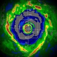
Looks like the "eye" has shifted more E of N and Lake Charles will have more NE and N winds. If nothing else, hopefully that will keep the worst of the surge away from Cameron and Grand Chenier. Unfortunately this looks like Intracoastal City surrounding areas and points south of Lafayette will get worse surge than they experienced with Laura. This is the KPOE radar further away from the coast since KLCH was destroyed in Laura. So the crescent shape and lack of an eastern eyeband might be exaggerated a bit.
-
Vortex is starting to look tilted on radar. Low level echoes in the eastern eyeband versus mid level convection gradually displacing to the east. Looks like VWS is starting to win the battle.
-
Unfortunately it does look like the northern semicircle of the half-moon eyewall is heading right towards the Lake Charles area unless it can take a more eastward vector in its slightly E of N motion.
-
Visible satellite since daybreak..
-
Some bad flooding down in the Yucatán.
-
Meh... I look at the issue like this. If we were being successful with a program that was trying to be preventative in stopping hurricane landfalls, we're really sucking at it right now, as the track record has been horrible and has been the past five years. The economic toll has been pretty bad. So no real improvement in that regard. I don't even want to consider the other aspect, as if that was ever a real secret project and it got out, oh dear God. You're going to have entire regions go to war based on financial loss, human suffering, etc.. That is why I choose to think any such program is garbage. It doesn't make sense from a economic or practical sense. Furthermore there's just too much required need for any humans related to such a project to give up any semblance of a conscience, ethical and moral reason to live, much more live with themselves.
-
I've seen eyewalls look a lot worse. Delta seems to be holding its own right now. Surface layer temps drop off a few degrees Celsius from this point forward. However, divergence over the system and poleward mass evacuation of air above 250 hPa is increasing as well. That may help sustain lapse rates to avoid rapid weakening. As has been discussed to death however, VWS is affecting Delta, and that should increase, but not presently enough that the core is overly tilted just yet. That may happen by this evening however. I'd say a borderline Cat 1/2, 90-100 mph landfall this evening is a good call.
-
The Atlantic Basin has crossed 120 for ACE. By that metric alone, we're above average, but well shy of the 152 to be considered hyperactive by that metric alone. Granted, other metrics, mainly number of storms, number of landfalling hurricanes, etc., it has arguably been a hyperactive year. This year has been anomalous in number of systems intensifying close to land. We haven't really had a lot of long-tracking hurricanes beyond Paulette and Teddy, and even those struggled to maintain intensity long enough to be big ACE producers. After Delta, the long-range may give us a few more systems. Potentially another strong Caribbean system in the last half of October. Perhaps a few weaker central Atlantic systems. But it's going to wind down. I'd say we may squeeze out another 10-15 points to finish somewhere around 135. Again, just based on the ACE metric alone, certainly an active season, but far below what I was expecting. I think I had called for somewhere around ~170.
-
In the long-range, but the first little taste?
- 168 replies
-
- 3
-

-
- leaves changing
- temperatures
-
(and 2 more)
Tagged with:
-
If the eye will stay warm and clear, beyond the convection being a little more symmetrical, it will help the pressure to fall. The winds should correspond to mixing down better. Awaiting dropsonde data. Also, RE: VWS tomorrow.. Yes, it will eventually be impacting Delta from the west. Noticed this post by Ryan @1900hurricane who hasn't been around on the forum lately.
-
Color enhanced and classic AVN respectively... Really impressive expansion of the CDO.
-
Yeah, if it sounds like I am downplaying the wind threat, I apologize. I am just meaning there should be significant weakening versus the temporary maximum intensity Delta is attaining in the short-term. I would be surprised if it makes landfall as a Cat 3 or at least is able to sustain the kind of convection to mix down stronger radial winds aloft at that time. But of course you're correct. Even 60-100 mph gusts is going to be a nightmare for debris and already weakened structures, roofs, etc. Still think surge is the worst danger however due to the ever expanding size and fetch east of the core.
-
Those folks had short memories. Even after Camille, Frederic and Alicia weren't that long ago and made landfall with closed eyewalls. At any rate, Delta likely will not be a good example of a closed eyewall at landfall by any stretch. Unless 2020 deals to us something completely wack.
-
I think he meant they were the exceptions.
-
Laura and Michael both had 29-30°C SSTs right up to the shoreline. Michael's VWS decreased the closer it got to he coast. Laura's increased too late, essentially just after landfall, and wasn't able to disrupt its core. Delta's VWS should be infringing at least 6-9 hours prior to landfall. Some modeling even slows down Delta's forward motion near landfall which could allow shear and cooler SSTs to disrupt the core even further. That being said, Delta's circulation is going to be large and the surge impact will already have been attained regardless if it's falling apart at landfall.
-
Ring of 80-90°C cloudtops surrounding the eye now.
-
Yeah again intensification this evening and whatever more Delta can muster by midday tomorrow matters only in fetch for surge. Winds are going to come down by landfall but the radius of 34+ wind is going to continue increasing. This is going to be a surge event.
-
Hmm.. Wouldn't have thought W GOM majors were so rare in October.
-
Excellent post by Philippe Papin: https://twitter.com/pppapin/status/1314350609924067328?s=19
-
[emoji106]
-
That's a mid-upper low. It's evolving into a stronger ULL due to backside outflow / TUTT off of Delta. Actually, I think you were being facetious here. Anyway... yeah.
-
-93°C in those towers within the NW semicircle.


