-
Posts
4,734 -
Joined
-
Last visited
Content Type
Profiles
Blogs
Forums
American Weather
Media Demo
Store
Gallery
Everything posted by Windspeed
-
CI# /Pressure/ Vmax 6.1 / 941.1mb/117.4kt At this rate, it will be Super Typhoon Lan by 00z.
-
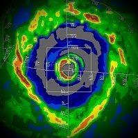
Lan is rapidly intensifying. ADT CI# is 112 kts and rising fast. Colder tops and the CDO is expanding NW of the 50nm wide eye now, which has warmed significantly the past few hours. Still 24-36 hrs of low-to-moderate shear but with an ever increasing 200mb poleward jet steak. The diameter of the eye will slowly contract some and I suspect ADT will hit 130 kts or more before Lan begins to weaken. JTCW will probably re-up the intensity forecast some. This is a massive-sized core, but perhaps a Super Typhoon is still a possibilty afterall. Edit: Good grief, to be so short, this typhoon's name is plaguing me. I keep hitting the freakin' m key!
-
Yeah, Lam likely matures into a large and powerful typhoon with a big stable eye over the next 24-36 hrs.
-
You nailed it. That has been the issue. Lam developed as multiple surface circulations formed within a large surface trough. Over the past week, surface vorts have been competing within the large gyre. When you have that scenario, deep convection within one vort can suppress convection or create subsidence that affects parts of the overall core structure. However, it looks like a deep band is getting established and a dominate vortex will take over. The SSTs are plenty warm up to southern Japan. It may not reach Super Typhoon status, but I think it will definitly be a Cat 3/4 before the the typhoon nears Japan. Perhaps holds intensity enough to landfall as a 3.
-
My main point was to show that you do not need deep oceanic heat content for a fast moving cyclone. Often times people post these OHC images as evidence for rapid intensification, but in my opinion, it is of far less importance for fast moving hurricanes versus the overall upper-level atmospheric environment. These NOAA maps that show depth of the 26° isotherm and also TCHP in the Gulf of Mexico are far more critical in slow to moderate motion in cyclones where their own upwelling below the shallow surface layer can affect intensity. Another hurricane I completely forgot to mention is Harvey. Here is another example of a hurricane that rapidly intensified over a shallow shelf just off the SE Texas coast. The immediate surface layer was around 30-31° C at the time. But Harvey's core had already moved away from deeper oceanic heat content and a deep warm eddy. See the CIMSS image: http://cimss.ssec.wisc.edu/goes/blog/wp-content/uploads/2017/08/Harvey_track_OHC.jpg The shallow surface layer was essentially overkill to support rapid intensification. The improving upper-level environment became spectacular near the coast however, and the models had been hinting at a favorable 200 mb pattern in the days proceeding Harvey's rapid intensification. The reason I cited Camille in the post above is that it is an example of a Category 5 that actually reintensified over the shallow shelf just east of Louisiana. In late August, the shallow surface layer near eastern Louisiana / southern MS-AL coast would have been around 30-31° C, similar to what we observed under Harvey just off Texas coast. I worry that we will see another Camille again. Granted, October the SSTs have dropped enough. But in the prime GOM months of July and August, I have little doubt a Category 5 can make landfall along the northern Gulf coast. We have developed a preconception of that region of the GOM due to recent examples of major hurricane landfalls. But it just takes the right upper-level environment and storm motion to change or erase that conception.
- 46 replies
-
- 2
-

-
- historical tropical cyclones
- hurricanes
-
(and 3 more)
Tagged with:
-
Much has been discussed in various tropical cyclone threads on this forum and the old predecessor Eastern Wx forums over the past 17 years about the northern Gulf of Mexico and its unfavorability in sustaining major hurricane landfalls. Even as recently a Hurricane Nate, the discussion was brought up again. Though Nate was not a major hurricane, nor was it forecast to be, it was forecast by the NHC to reach 90 kts / 105 mph by landfall. Nate did not reach Category 2 intensity however, and even appeared to weaken more significantly than the official advisory prior to landfall; though we will need reanalysis to perhaps know for certain just how much weakening occurred. Either way, it is clear Nate did not strengthen or maintain its structure into landfall. Convection waned, the core appeared to collapse and the NE eyewall barely held its curved banding into the MS coastline. As such, discussion linked Nate to the unfavorability that exists there. I disagree with this conception, however. Hurricane Nate is not a good example of a cyclone sustaining intensity due to SST environmental conditions. Nate was a hurricane with a small core that was under a extremely fast steering regime. Convective mesos would form, rotate to the western half of the circulation and collapse. This happened at a near constant rate as its forward motion increased until it couldn't manage to close off its eyewall vortex. At multiple points on track, an eyewall would develop only to pivot around into a new intensifying meso. I think recon may have measured hurricane force winds within the stronger east side of these mesos, but I am not so sure Nate ever held a steady state intensity for prolonged periods. It's quite possible the core would reattain hurricane force during each meso, but an eyewall band had trouble establishing overall dominance as the core vortex feature. Whether the shallower heat content had an effect I believe is insignificant compared to the unfavorable flow against the western half of the hurricane. Perhaps radial convergence and evaporation feed of heat flux really was suffered by Nate. The storm was just moving way too fast for it to take advantage of any immediate sea surface heat layer, much less heat content at depth (regardless of its presence). Understand that I have been skeptical of forward motion, low-level convergence and heat flux being a significant factor, but I am now wondering if this is a critical to sustainment of eyewall convective banding as upper-level divergence over LLC core may be overwhelmed or disrupted with meso scale vortices updrafts within the inner periphery of the low-level vortex in rapidly moving systems such as Nate. This may not have been as much a negative factor for an already well-organized surface vortex, but Nate seemed to be struggling with this process even as a hurricane. We also have plenty of examples of hurricanes intensifying at landfall in the northern Gulf over the shallow surface layer to contend with the hurricanes that weakened. Alicia, Fredrick and Camille (after completing an ERC) are some of the more notable cyclones. The most intense major hurricane to be shown to have reintensified by landfall in reanalysis is Camille. Though it weakened during an ERC SSE of the mouth of the Mississippi River when the tiny inner eyewall finally collapsed, a bright outter ring representing the outter eyewall contracted quite rapidly. It did not lose its structure and in fact appears to have sustained nearly a 360° 12 nm closed band right at landfall at Waveland, MS. See linked animation .gif of landfall and PDF of reanalysis. Now clearly, shallow surface layer SSTs in August near the northern Gulf coastline are warmer than in October. We typically observe 29-31° C shallow surface water by late August without any significant frontal interaction. By October, the shelf typically drops a few degrees. But 28° were still being observed in Nate's track. That would have been sufficient to support a major hurricane, especially a fast mover. Unfortunately, Nate was moving so fast, it began to collapse before the shallow layer even mattered. We have seen rapid motion in major hurricanes before. Charley was moving around 20 mph when it underwent rapid intensification from 95 to 125 kts and a 27 mb pressure drop in less than 8 hours. But when Charley's core gained faster forward motion, it already had a well organized and symmetrical core. Interestingly, though it did not cross over the northern Gulf shallow shelf, it was crossing the shallow shelf off of SW Florida, north of the Keys. Wilma also intensified crossing this shallow shelf. OTOH, Nate was in the process of developing its core vortex the entirety of its track across the W. Caribbean and GOM between 22 and 26 mph. These are purely tropical cyclone examples. We can also cite the rapid motion of the 1938 Long Island Hurricane; however, this storm was likely undergoing rapid baroclinic forcing as well, which likely sustained intense convection and major hurricane force winds/surge straight inland. Some majors that weakened at landfall are obviously noteworthy. Katrina, Rita and Ivan are mentioned frequently. But every one of these systems were battling significant shear as well. Ivan is an interesting case as it managed to remain 105 kts Category 3 even with 30 kts of mid-level shear advecting dry stable air into its core. The northern and eastern eyewall band held together quite well. With past hurricane examples of intensifying storms into the northern Gulf coast, these systems were all in a more favorable upper-level environment. Even though Nate was in a low shear environment, the western circulation northerly flow was hampered by such strong opposing directional mid-level flow. I think if Nate had been a slower moving storm, being a purely tropical entity, it would have been able to reach Category 2 intensity at landfall. Perhaps even strengthen all the way into landfall. But this is speculative. I'm only wanting to point out that the sea surface environmental aspects were not its doom. Edit: I initially intended to preview and correct typos, but I accidentally submitted the entire post prematurely. If you read this post within the first hour of submission, you may want to reread before commenting. Thanks!
- 46 replies
-
- 3
-

-
- historical tropical cyclones
- hurricanes
-
(and 3 more)
Tagged with:
-
Often times posters will discuss, compare and contrast historical tropical cyclones and their climatology during an active event thread, but these posts end up buried amongst the overall meteorological storm discussion for obvious reasons. I am opening this thread for current and future discussion as it relates to past tropical cyclone events and their peer-reviewed reanalysis projects. If any person wishes to post about, reminisce or debate past tropical cyclones, regardless of oceanic basin or sea, perhaps they carry that on in this thread so we may have an easier flow of information and archive of such discussion. I have quite a few cyclones to discuss myself and existing preconceptions / misconceptions about a particular region of the Atlantic to flesh out. My first post will be later this evening. But don't wait on me.
- 46 replies
-
- 1
-

-
- historical tropical cyclones
- hurricanes
-
(and 3 more)
Tagged with:
-
I think they might be a little too north in their forecast track. Of course it could gain a more WNW motion between now and landfall, but it really looks to be bullseyeing the mouth of the Palanan River.
-
The forecasted location of landfall receives more severe landfalling cyclones than any place on Earth. That combined with the mountainous terrain of the region probably has a lot to do with the far less densely populated geography as compared to the rest of the Philippines. However, there are small villages and townships still located along the coastline of northeastern Luzon. Hopefully the center makes landfall where one of those villages aren't located. Additionally, you are correct about the threat of inland flooding. This typhoon has a powerful circulation with a very low pressure. As it pushes west, it will be a big threat to higher populated regions of central and western Luzon. That risk can certainly not be downplayed. Edit: Divilacan Bay has several small coastal townships that are the closest to the current projected landfall point. That area was also blasted by Super Typhoon Megi in 2010. Inland flooding from that typhoon displaced 200,000 people as it moved across Luzon. https://en.m.wikipedia.org/wiki/Divilacan,_Isabela https://en.m.wikipedia.org/wiki/Maconacon,_Isabela
-
Ok, great! It wasn't showing any changes for several hours. Glad they're up. Anxious to see what they have to report besides.
-
The last report from the airport in Banco, which looks like it positioned just under the southern and southeastern edge of the intense eyewall, reported sustained SW winds of 96 mph and gusts to 116. https://www.wunderground.com/ph//basco/zmw:00000.1.98135 No reports out of the island of Itbayat. EDIT: Whooooa there... Banco airport last report is S wind @ 122 mph, 150 mph gust. I don't think it was under the worst of the backside eyewall either. Also looks like they're getting raked with a nasty intensifying outer eyewall.
-
Think I'm buying that 160 kts now. May be even higher. Very symmetrical and expansive cold ring and the eye has further warmed. Really impressive system. In reference to the comparison to Haiyan earlier, Haiyan had a slightly colder ring, but it may have been low-balled on its peak intensity estimates anyway.
-
Very close call for the southern tip of Taiwan. The cyclone will probably have a larger core by the time it is at closest proximity there. Even if the inner eyewall doesn't make landfall, it's very likely a concentric outer wall will impact land and they will experience typhoon force winds. For later today, the 06 HWRF has the northern Batanes nearly in the southern eyewall. The town of Banco is in the NW inlet of Batan proper. They will likely experience typhoon force winds even if the eyewall misses the island to the north.
-
Yeah, looks like model consensus has shifted south as has JTWC's official forecast. Looks like the core will miss Taiwan and China's mainland will be dealing with a stronger intensity at landfall than previously forecast. This could end up the worst direct wind impacts at landfall for China for many years. The core will likely weaken and drop down to upper Category Three status due to internal reorganization and an expansion of pressure gradient /wind field, but Meranti may have a much larger core by then, affecting a larger area of shoreline with typhoon force winds.
-
Haiyan was at a much lower latitude and had better upper tropospheric forcing. Probably the most incredible structure and symmetry we've ever seen in a tropical cyclone. I don't think Meranti can eclipse that. Inevitably, it is going to go through an internal structural change. It may have even peaked. As has been repeated, I wish they had recon over there.
-

Devastating tornado strikes Joplin, Missouri
Windspeed replied to Hoosier's topic in Weather Forecasting and Discussion
A .75-1 mile wide wedge tornado with roughly 40mph forward motion combined with EF5 intensity; the circulation had to have some pretty intense inflow. I would consider that the reason it lasted so long wasn't necessarily because folks were inside the condensation of the wedge for 2-3 minutes, but were getting hammered with 60-100mph wind gusts 30-40 seconds before and after it plowed through them. I can't imagine the terror of experiencing such intensity for so long when everything around you is obliterated and the shrapnel-laden wind is basically the equivalent of a shotgun blast. -

Devastating tornado strikes Joplin, Missouri
Windspeed replied to Hoosier's topic in Weather Forecasting and Discussion
This may be the most real and disturbing literature I have read with regards to the events that unfolded that day. For all the fascinating aspects of severe weather, the human aspect of loss and death is something that gets separated from science, statistics and the curiosity we all share. We all pour over "the incident" as this thing of wonder and amazement. We all live vicariously through those that experience natural disasters first hand. But in the telling of a personal experience, such as this one, you feel the pull on that place in your guts that makes you a human being. Thanks for posting this, Jomo. Glad you and yours survived unscathed, physically, at least.

