

Windspeed
-
Posts
4,734 -
Joined
-
Last visited
Content Type
Profiles
Blogs
Forums
American Weather
Media Demo
Store
Gallery
Everything posted by Windspeed
-
 Marcus will definitely be among the most powerful tropical cyclones of 2018:
 -
Severe Cyclone Marcus is a Category 5 on the Australian scale. It would probably be a Cat 5 on the US and Japan scales at some point as well. The cyclone looks to have completed an ERC and the eye that was partially covered in cloud debris appears to be clearing again. Dvorak is closing on AdjT#7 and 135 kts. The CDO is symmetrical with a thick ring of -80°C tops and MW representive of an intense eyewall. Here's the current Aus Met advisory:
-
That was likely a violent long-tracker unfortunately.
-
I was referring to the cell between Cullman / Good Hope i65 and Arley, AL. Though the rotation has weakened now.
-
Cell ENE of Arley, AL probably about to be tornado warned.
-
Cullman cell is intense. Looks like they are getting rocked with possible 2-3" hail over downtown.
-
The strong cell / updraft SE of Addison, AL looks like it may be on the verge of producing. Signs of a couplet forming.
-
Cell near the state line is bearing down on i-65. Looks more and more impressive. Will pass very near Ardmore.
-
That's an impressive donut meso on the state line cell...
-
That cell near the AL/TN line may be trying...
-
This was earlier as the couplet was moving through Russellville.
-
Tight couplet west of Russellville, AL.
-
That is a nasty hail core on the super cell near Belmont in Tishomingo County, MS.
-
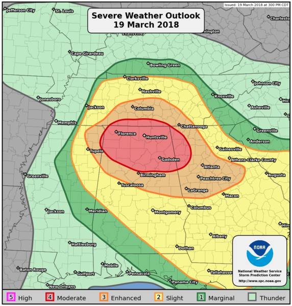
Today's SPC PWO risk graphic for posterity.
-
http://www.spc.noaa.gov/products/watch/ww0014.html
-
Good to know. Thanks!
-
Yikes...
-
Good morning. I suspect we're in for a long evening and night. Good luck to everyone as far as hail or wind damage. And don't forget to unplug your sensitive electronics and hardware if you're going to be away from your home this afternoon-evening. Sometimes surge & ups fail and warranties can't replace everything.
-
Cyclone Marcus has been quite nuisance for Darwin and Kimberley in N. Australia the past few days. The core will be pulling away from the coast on Monday and will put on quite a show this week in the SE Indian Ocean. Forecast reasoning and modeling suggests a rapidly intensifying and prolonged cyclone event and Marcus may reach Category 5. Fortunately it will be doing so a good distance away from land.
-
**Warning: Loud volume with explicit language** I saw this video on another site that mentioned near Etowah. Save your ears and adjust volume down prior to viewing.
-
SPC is definitely leaving the door open for a possible upgrade as well: "Given the potential for significant severe storms, a categorical upgrade is possible in later outlooks once predictability increases and the centroid of severe coverage is better established."
-
The Lawrenceburg footage is very intense. Perhaps the most violent tornado ever recorded in Tennessee on video. Though the 20 mile path traversed sparsely populated communities, still quite miraculous that it resulted in no deaths.
-
Day of the EF-4 Henryville, Ind. tornado: ..and that same day near Chattanooga, an EF-3 hit Ooltewah and Cleveland, Tenn., and also this EF-2 in Etowah:
-
Those super cells earlier produced some minor wind damage reports but nothing tornadic fortunately. Probably haven't seen the last FFWs tonight though. Some serious heavy rainfall in these cells over NE AL and NW GA.
-
Some organizing supercells moving towards north-central Alabama. Weak rotation but nothing yet tornadic.

