-
Posts
4,733 -
Joined
-
Last visited
Content Type
Profiles
Blogs
Forums
American Weather
Media Demo
Store
Gallery
Everything posted by Windspeed
-
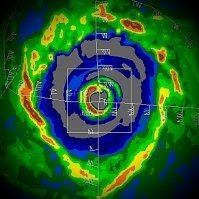
Bad timing perhaps. Harold's latest ERC looks to have completed and some reintensification may underway just before landfall on Kadavu Island:
-
Harold's core just missed greater Fiji to the SW. But Kadavu Island (pop.~10k) will take a direct hit. Images/gif courtesy of Brian McNoldy @ University of Miami RSMAS: http://bmcnoldy.rsmas.miami.edu/tropics/harold20/Harold_7-8Apr20_nadi.gif
-
Round one tomorrow evening/night..
-
And of course the one we've been watching for: The trough/phase dynamics at play, leading to a potential outbreak on Easter Sunday. This might be a doozy:
-
Possible severe on Wed evening into Thurs AM?
-
Incredible recovery by Extreme TC Harold from land interaction over Espiritu Santo, Vanuatu. This is a textbook study right here before our eyes. I've never seen anything like this previous.
-
Extreme TC Harold has made landfall over the southern periphery of the island of Espiritu Santo, Vanuatu. Fortunately this region is not as populated as the northeastern region of that large island. Whoever is there is likely getting rocked however. Nice presentation through landfall. The eyewall was strong even if old cloud debris from the ERC was still clearing out within the new eye. Will be interesting to see how much land interaction influences weakening. I suspect there will be some weakening as Harold continues ESE.
-
-
FWIW, I've read data ingestion for the major models is being affected by a lack of global flights. I do not know how accurate this is or, if an issue, how wacky mid-to-long range modeling will become as we go forward the next month.
-
Cyclone Harold is rapidly intensifying and will likely make a direct landfall in Vanuatu as a powerful upper category cyclone in the coming days. Which island that will be still remains in question but there may be multiple landfalls based on the general forecast path.
-
Seasonal forecasts are beginning to make their way out from respected scientists in the field to media and news outlets. The majority of specialists are predicting a hurricane season with above-normal activity. ENSO looks to be swinging neutral to perhaps even a La Niña by July-September. Western Atlantic subtropical and tropical SSTs are running above average overall with some particularly noticeable 2-3°+C deviations in the GOM and W. Caribbean. Could 2020 be hyperactive? AMO and NAO may present both favorable patterns for not only hurricanes in the MDR, but potential land threats to the W. Caribbean and GOM as well this season. Bermuda-Azores ridging may also dominate the SER/WAR steering pattern during Cape Verde season. This might be a year where we even see a few long-trackers reach Central America.
-
Oh if only this pattern had been in place a few months ago. Insult to injury I suppose. Now just wanting this to break fast and we can get on with Spring.
-
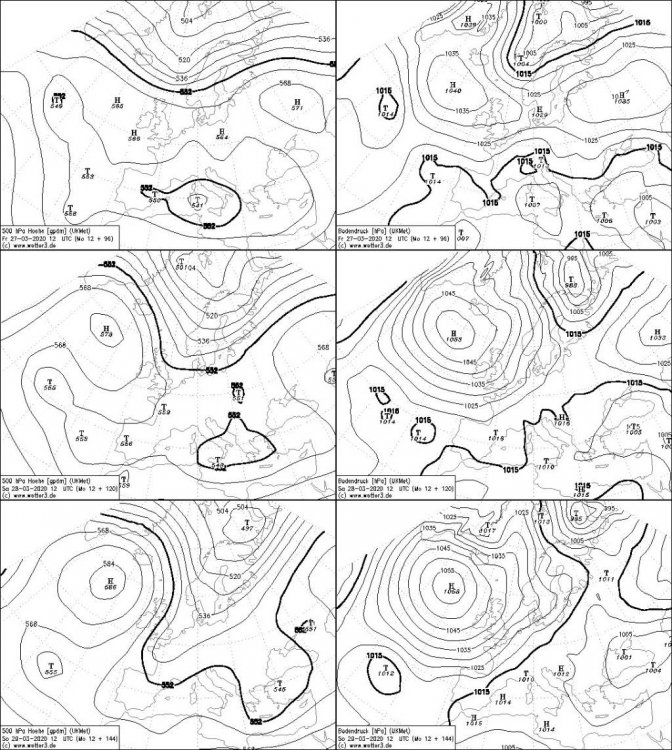
-NAO incoming? Some of the globals are hinting into next week but there is clearly an NAO influencing beast near Iceland showing up in the recent ECMWF and Ukie runs. The 12z Ukie is nuts. 1058hpa and 600dm vacuum buster incoming.. Edit: Will be interesting to see if this shifts and locks down into a classic Greenland block or splits anticyclonically into a +NAO/N. Euro block. Therefore, I may've been a wee bit premature. I suppose -NAO isn't necessarily a sure thing.
-
Some of you may've already seen this video but thought I would share anyway. Posting here not to clutter the Severe Weather thread up so far post event.
-
I agree, Carver. I think this Summer is probably leaning hot and dry for interior SE CONUS. Nino 3-4 is still about average to slightly above near surface but there is sub 22-24° isotherm progressing upward and Nino 1-2 is already running 24° near surface. A moderate La Niña looks in play at this point, and orientation of the Azores-Bermuda ridge axis may very well torch us July-September. NMME guidance suggests a strong La Niña presence into Winter. Still, high and dry isn't an absolute certainty. You never know how much low-level tropical feed can downplay/offset potential drought. Yes, WATL 500dm heights are critical to overall pattern but it doesn't take too much displacement to swing dry hot vs humid hot with plenty of afternoon/evening convective showers. OTOH, hints that the Atlantic MDR may run quite bit above normal by July. The deep MDR, especially the 50°W to the Verdes is running above average. Are we looking at a hyperactive NATL tropical season? I am starting to think so. Again, how strong do Western ATL heights remain in place through late September? Will there be enough blocking in place to keep everything south of the region? This may be a bad year for Mexico and W Caribbean impacts. But something may sneak up here to alleviate our dry conditions as well. That is to say, I wouldn't count out some early tropical season respite (June-July) from the GOM with a few stalled-out variety tropical lows. August-September might truly be the dog days of Summer this year however.
-
Plenty of incredible damage videos and images, but this particular photo of the damage path looking east towards Cookeville is disturbing. Any number of deaths is awful and I am certainly not downplaying this tragedy for those suffering, only just to say that considering the time of night and the track/damage path, it is perhaps a miracle the numbers aren't much higher. Please consider finding a legitimate donation fund setup to help those in need.
-
Some crazy survival stories coming out of this long-lived tornado. I do wish news agencies would stop referring to the event as an "outbreak" however. https://www.cbsnews.com/news/nashville-tornado-putnam-county-death-toll-rises-today-2020-04-03/


