Jump to content

Windspeed

Members
  • Posts

    4,155
  • Joined

  • Last visited

Everything posted by Windspeed

  1. Hugo's outflow and CDO was amazing for it to have been moving at 23 kts. That remains the best looking Atlantic hurricane north of 30°. But I agree, Florence is also excellent.
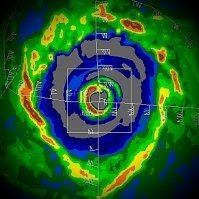
  2. 207 WTNT41 KNHC 132052 TCDAT1 Hurricane Florence Discussion Number 58 NWS National Hurricane Center Miami FL AL062018 500 PM EDT Thu Sep 13 2018 The satellite and radar presentations of Florence have changed little this afternoon with a 20-25 nmi wide eye waxing and waning as intrusions of dry air have occasionally eroded the southern and eastern eyewall. Despite the occasional ragged appearance of Florence's eye, reconnaissance aircraft data indicate that the central pressure has remained steady at 955 mb. The last reports from the Air Force Reserve hurricane hunters support an intensity of 85 kt, and this is corroborated by average Doppler velocity values of near 105 kt at 2500-3000 ft ASL. A report of a 10-minute average wind of 59 kt and a gust to 74 kt was recently received from the Cape Lookout C-MAN station (CLKN7). The 59-kt 10-minute wind speed is roughly equivalent to a 65-kt 1-minute wind. Florence has continued to slow down, and radar fixes over the past couple hours suggest that Florence has possibly stalled due to a re-organization of the eye/eyewall. Smoothing through the fixes over the past 6 h yields an initial motion estimate of 295/04 kt. There is no change to the previous forecast reasoning. The ridge to the north and east of Florence remains intact over the Atlantic Ocean, but water vapor imagery and special upper-air observations indicate that a shortwave trough has weakened that portion of the ridge along the U.S. mid-Atlantic coast, resulting in a weakening of the steering currents. The ridge is forecast by all of the latest model guidance to remain intact, albeit weak, for the next 72 hours, which will nudge Florence on a slow westward to west- southwest track into central South Carolina. On days 4 and 5, Florence is expected to become an extratropical low as it interacts with a front while moving northward and northeastward along the Appalachian Mountains. The official forecast track is similar to, but slightly south of the previous advisory track through 72 hours, with little change indicated on days 4 and 5. This scenario closely follows the simple consensus model TVCN/TVCA, which is north of the corrected-consensus models HCCA and FSSE, which are heavily weighing the southernmost model, ECMWF, which keeps Florence over or near the Atlantic through about 48 hours. Radar data indicate that Florence may be developing an outer eyewall. If this trend continues, then little change to the intensity is likely until landfall occurs in about 24 hours due in part to the low vertical wind shear conditions and the warm, deep waters of the Gulfstream current. Florence is expected to weaken after landfall, but the rate of weakening may be tempered somewhat due to much of the hurricane's circulation remaining over the warm waters of the Atlantic Ocean and Gulfstream. Once Florence moves farther inland over central South Carolina, rapid weakening of the inner-core wind field should occur due to land interaction and the cyclone's slow forward speed of 5 kt or less. However, intense rainbands are expected to continue developing over the Atlantic waters and keep moving along the coast and inland, likely producing strong wind gusts through Saturday night. Aircraft and satellite wind data show that Florence remains a large hurricane. Life-threatening storm surge, heavy rainfall, and damaging wind will cover a large area regardless of exactly where the center of Florence moves. Key Messages: 1. A life-threatening storm surge is highly likely along portions of the coastlines of South Carolina and North Carolina, and a Storm Surge Warning is in effect for a portion of this area. The greatest storm surge inundation is expected between Cape Fear and Cape Hatteras, including the Neuse and Pamlico Rivers and western Pamlico Sound. 2. Life-threatening, catastrophic flash flooding and prolonged significant river flooding are likely over portions of the Carolinas and the southern and central Appalachians through early next week, as Florence is expected to slow down as it approaches the coast and moves inland. 3. Damaging hurricane-force winds are likely along portions of the coasts of South Carolina and North Carolina beginning this evening, and a Hurricane Warning is in effect. Strong winds could also spread inland into portions of the Carolinas. 4. Large swells affecting Bermuda, portions of the U.S. East Coast, and the northwestern and central Bahamas will continue this week, resulting in life-threatening surf and rip currents. FORECAST POSITIONS AND MAX WINDS INIT 13/2100Z 33.7N 76.2W 85 KT 100 MPH 12H 14/0600Z 34.1N 77.2W 85 KT 100 MPH 24H 14/1800Z 34.2N 78.2W 75 KT 85 MPH...INLAND 36H 15/0600Z 33.9N 79.0W 50 KT 60 MPH...INLAND 48H 15/1800Z 33.8N 79.9W 35 KT 40 MPH...INLAND 72H 16/1800Z 34.8N 82.3W 25 KT 30 MPH...INLAND 96H 17/1800Z 37.9N 82.6W 20 KT 25 MPH...POST-TROP/INLAND 120H 18/1800Z 42.7N 76.3W 20 KT 25 MPH...POST-TROP/INLAND $$ Forecaster Stewart
  3. To be fair, this is the best radar presentation Florence has had since coming into range. But Florence probably will still be steady state unless it continues with the deep convection and the eyewall continues organizing.
  4. Yes, the OHC of the Gulf Stream is pretty high and the 26°C isotherm is very deep. There will still be upwelling off the shelf in short order however due to NW flow perpendicular to the coast in the southern circulation. But half of the circulation will remain over the GS if it begins SW motion faster than forecast.
  5. The cloud pattern is beginning to orient itself against the positively tilted mid-level ridge that stretches from the Tennessee Valley into the upper Mid-Atlantic. We may very well have a weak NE to SW steering flow setting up and Florence may begin moving towards the SC coast.
  6. Now that Florence has slowed significantly, I am most curious if the 12z ECMWF will continue resolving SW motion down the SC coastline or go ahead and slide Florence inland over Florence, SC, as the GFS and GEM are showing.
  7. I agree with Levi. The circulation of Florence is large. However, as some other posters have pointed out, you don't help the situation if favorable environmental conditions improve. You want this hurricane to fall apart. If the hurricane gains convection and reorganization of the core, you increase the odds that a devastating surge event occurs at this point. Nobody is expecting a Hugo here, at least with regards to wind speeds. But you already have destructive surge incoming due to Florence's large circulation. You want Florence to fall apart as much as possible to mitigate it. You do not want Florence to recover and exacerbate that perpendicular surge from onshore flow up to landfall.
  8. The easterly outflow channel moving away from the western side of the cyclone looks really impressive right now. Keep in mind, Florence has a large circulation and any intense convection may not translate to a rapid increase in vortex wind speeds. Having said that, the higher OHC, what looks like increasing upper-level environmental support and slow progression across the Gulf Stream, Florence may go to town tomorrow. I really like the look of the CDO at the moment. It has the look of a cyclone about to intensify versus one that is degrading and falling apart. Fascinating stuff at such a high latitude.
  9. 874 WTNT41 KNHC 130249 TCDAT1 Hurricane Florence Discussion Number 55 NWS National Hurricane Center Miami FL AL062018 1100 PM EDT Wed Sep 12 2018 Satellite data and reports from Hurricane Hunter aircraft indicate significant changes in the structure of Florence and the environment near the storm since the last advisory. Microwave satellite imagery shows that the convection on the southern side of the storm has been disrupted, and reports from an Air Force Reserve Hurricane Hunter aircraft indicate the eyewall now wraps less than 50 percent of the way around the center. The aircraft also reports that the hurricane again has concentric wind maxima, the inner at a radius 20-30 n mi and the outer at 50-60 n mi. The convection seems to have been affected by 20-25 kt of southerly vertical wind shear, most of which appears to be due to strong winds between 200-250 mb seen in dropsonde data from the NOAA G-IV jet. The central pressure has risen to 957 mb, and the maximum 700-mb flight-level winds reported so far are 103 kt. Based on the latter data, the initial intensity reduced to a probably generous 95 kt. The initial motion is 315/15. During the next 12-36 hours, the hurricane is expected to turn toward the west-northwest and west with a decrease in forward speed as it moves into an area of weakening steering currents near and over the southeastern United States. The new forecast track now brings the center onshore in southern North Carolina near the 36 h point. After landfall, the cyclone should move slowly westward to west-southwestward through the 72 h point, then it should turn northwestward to northward by the end of the forecast period as it moves through the Appalachian Mountains. The new forecast track lies between the HCCA corrected consensus model and the other consensus aids, and it is nudged just a little to the north of the previous track. The dynamical models forecast the current shear to subside after 6-12 h as Florence moves farther from an upper-level low currently near northeastern Florida. This, combined with sea surface temperatures near 29C, would allow a last chance for strengthening before landfall. However, the storm structure, particularly the large outer wind maxima, would likely be slow to respond to the more favorable environment. The pre-landfall part of the intensity forecast thus calls for little change in strength, but given the uncertainties the confidence in this is low. After landfall, Florence should gradually weaken during the 36-48 h period while the center is near the coast, then weaken more quickly when the center moves farther inland. While Florence has weakened below major hurricane intensity, the wind field of the hurricane continues to grow in size. This evolution will produce storm surges similar to that of a more intense, but smaller, hurricane, and thus the storm surge values seen in the previous advisory are still valid. The threat of rainfall has also not diminished, and these impacts will cover a large area regardless of exactly where the center of Florence moves. Key Messages: 1. A life-threatening storm surge is now highly likely along portions of the coastlines of South Carolina and North Carolina, and a Storm Surge Warning is in effect for a portion of this area. All interests in these areas should complete preparations and follow any advice given by local officials. 2. Life-threatening, catastrophic flash flooding and prolonged significant river flooding are likely over portions of the Carolinas and the southern and central Appalachians late this week into early next week, as Florence is expected to slow down as it approaches the coast and moves inland. 3. Damaging hurricane-force winds are likely along portions of the coasts of South Carolina and North Carolina, and a Hurricane Warning is in effect. Strong winds could also spread inland into portions of the Carolinas. 4. Large swells affecting Bermuda, portions of the U.S. East Coast, and the northwestern and central Bahamas will continue this week, resulting in life-threatening surf and rip currents. FORECAST POSITIONS AND MAX WINDS INIT 13/0300Z 32.0N 73.7W 95 KT 110 MPH 12H 13/1200Z 33.1N 75.3W 95 KT 110 MPH 24H 14/0000Z 33.9N 76.7W 95 KT 110 MPH 36H 14/1200Z 34.2N 78.0W 80 KT 90 MPH...INLAND 48H 15/0000Z 34.1N 78.7W 60 KT 70 MPH...INLAND 72H 16/0000Z 33.5N 80.5W 40 KT 45 MPH...INLAND 96H 17/0000Z 34.0N 83.0W 25 KT 30 MPH...INLAND 120H 18/0000Z 37.5N 83.5W 20 KT 25 MPH...POST-TROP/REMNT LOW $$ Forecaster Beven
  10. Old mid-level eye clouds and cirrus canopy on satellite can be deceiving versus actual center fix of core surface circulation. Also, concentric outer banding may be closer to actual recon fix and progressive evolution for tracking, regardless if the NW banding becomes a new eyewall. It's certainly more difficult in degraded presentation to follow on satellite. Simply put, focusing on the cloud pattern of that old eye may mislead you versus actual recon center fix.
  11. Media bashing in the main thread is pissing me off. Get it out of the main thread. Also, network media has to stop their regularly scheduled opinionated bull**** for a few days to actually grab the attention of the majority of desensitized Americans, who don't respond or react to anything unless they're drowning in an ocean of hyperbole anyway. You think presenting facts is going to get some fatass off their couch, much less out of their surge-prone house? "Disclaimer: There's a chance this hurricane could rapidly weaken or miss your location entirely." Give it a bloody rest. They're mostly not scientific meteorologists and they're also not perfect. They're media people interpreting information they are given while presenting that dangerous threat to the viewer. Regardless if the hurricane collapses into butterfly wings, the forecast was presented to them by official agencies as a devestating event based on evidence at the time of forecast. They reported it the best way they can. If you don't like it, just give it a week and you can go back to the opinionated hyperbole-filled political segments people seem to live for these days.
  12. I think the large circulation and expanded vortex / core structure goes against conventional reintensification. Deep convection and improvement of the core over the Gulf Stream could help to drop pressure again, but it would probably not be able to retighten the core gradient enough for a substantial increase in vortex wind speeds. Perhaps it maintains a steady state longer. However, this is inconsequential to the greatest shoreline threat. I am already bought into the massive surge threat Florence poses due to it having already been an intense hurricane, then developing a large wind field in the northern semicircle of the surface circulation and pushing fetch perpendicular to the Carolina shoreline.
  13. Also the slow down will prolong the onshore flow. The rise in ocean heights will continue to flow into inlets and estuaries for 48 hrs into the southern and central North Carolina coastline. It won't be able to retreat like a normal or faster landfall. You want the strong onshore flow to get out of there as fast as possible to stop piling up the fetch that has already been acquired and carried with the hurricane. Having it slow down and never getting offshore flow due to the prolonged slow motion and bend SW makes a bad situation worse. I expect surge projections near Wilmington to verify. The only way they do not is if Florence slows down much earlier than forecast and turns SW staying well away or off the North Carolina coast. This could carry the threat SW. There would still be surge, but that could help alleviate it. As current track stands, however, projections likely will verify unfortunately.
  14. Your lack of knowledge about TCs speaks for itself. Fetch for surge has already been acquired. Prolonged onshore flow on the north side of Florence's circulation is a worse case scenario. Matters little that the core vortex even drops below Cat 1 at this point. Large expanded windfield and slow down perpendicular to coastline is absolutely the issue.
  15. 677 WTNT41 KNHC 122042 TCDAT1 Hurricane Florence Discussion Number 54 NWS National Hurricane Center Miami FL AL062018 500 PM EDT Wed Sep 12 2018 Data from an Air Force Reserve hurricane hunter aircraft along with satellite imagery and various intensity estimates indicate that Florence has weakened instead of strengthening. However, while the hurricane hasn't strengthened in terms of peak winds, the inner-core and outer wind fields have continued to expand, resulting in an increase the cyclone's total energy, which will create a significant storm surge event. The upper-level outflow remains impressive and is still expanding except toward the south. Florence is moving toward the northwest or 315/14 kt. The new 12Z global and regional model runs have come into much better agreement on Florence moving steadily northwestward around a strong ridge located between Bermuda and the U.S. mid-Atlantic region for the next 48 hours or so. By late on day 2, Florence is forecast to approach the southern portion of the North Carolina coast, then slow down considerably and turn westward within collapsing steering flow, with a very slow westward motion near the coasts of North and South Carolina continuing into Friday and Saturday. Corrected-consensus models HCCA and FSSE remain very close to each other and are quite similar to the simple consensus model TVCA. Therefore, only a slight eastward shift was needed to the previous forecast track through 36 hours or so, mainly due to the more eastward initial position based on the reconnaissance fixes. At 48 hours and beyond, no significant changes were required to the previous advisory track, which still shows Florence moving slowly westward across South Carolina and western North Carolina on day 4, followed by a slow northward motion up the Appalachian mountain chain on day 5. A narrow window of opportunity remains during the next 24 hours or so for Florence to strengthen a little when the hurricane passes over the warmer SSTs and deeper warm water/higher upper-ocean heat content associated with the Gulf Stream, and low vertical shear conditions of 5-10 kt will aid in any strengthening process. However, significant strengthening is not anticipated due to Florence's large and expanding inner-core wind field. By 36 h and beyond, decreasing ocean heat content along with the slowing forward speed of Florence will likely produce cold upwelling beneath the hurricane, inducing a gradual weakening trend. When Florence moves over the shallow coastal shelf waters in 48-72 h, land interaction and more significant upwelling are anticipated, which should further enhance the weakening process. The NHC intensity forecast remains near the higher statistical guidance through 48 hours, then follows the trend of the decay SHIPS model after that time. Although the maximum winds are expected to weaken a little more, Florence is still expected to remain a dangerous major hurricane as it approaches the coast. The threat to life from storm surge and rainfall will not diminish, and these impacts will cover a large area regardless of exactly where the center of Florence moves. Key Messages: 1. A life-threatening storm surge is now highly likely along portions of the coastlines of South Carolina and North Carolina, and a Storm Surge Warning is in effect for a portion of this area. All interests in these areas should complete preparations and follow any advice given by local officials. 2. Life-threatening, catastrophic flash flooding and prolonged significant river flooding are likely over portions of the Carolinas and the southern and central Appalachians late this week into early next week, as Florence is expected to slow down as it approaches the coast and moves inland. 3. Damaging hurricane-force winds are likely along portions of the coasts of South Carolina and North Carolina, and a Hurricane Warning is in effect. Strong winds could also spread inland into portions of the Carolinas. 4. Large swells affecting Bermuda, portions of the U.S. East Coast, and the northwestern and central Bahamas will continue this week, resulting in life-threatening surf and rip currents. FORECAST POSITIONS AND MAX WINDS INIT 12/2100Z 30.9N 72.5W 105 KT 120 MPH 12H 13/0600Z 32.1N 74.1W 110 KT 125 MPH 24H 13/1800Z 33.4N 75.9W 110 KT 125 MPH 36H 14/0600Z 33.9N 77.1W 105 KT 120 MPH 48H 14/1800Z 34.0N 77.9W 100 KT 115 MPH...NEAR THE COAST 72H 15/1800Z 33.6N 79.2W 70 KT 80 MPH...NEAR THE COAST 96H 16/1800Z 34.0N 81.7W 30 KT 35 MPH...INLAND 120H 17/1800Z 35.6N 83.4W 20 KT 25 MPH...POST-TROP/INLAND $$ Forecaster Stewart
  16. 564 WTNT41 KNHC 120853 TCDAT1 Hurricane Florence Discussion Number 52 NWS National Hurricane Center Miami FL AL062018 500 AM EDT Wed Sep 12 2018 The eye of Florence remains very distinct in infrared satellite imagery this morning. There has been little change to the cloud top temperatures surrounding the eye overnight, however, the overall cloud shield and central dense overcast has become slightly more symmetric. An Air Force Reserve Hurricane Hunter aircraft that was in the hurricane until just after midnight measured a peak 700-mb flight-level wind of 130 kt, and a SFMR wind of 107 kt in the northeast eyewall. A blend of these data and recent subjective and objective satellite intensity estimates supports an initial wind speed of 115 kt. Florence will be moving over sea surface temperatures of around 29C and through an area of low vertical wind shear during the next day or so. These conditions favor some strengthening, but eyewall replacement cycles could cause some fluctuations in intensity during that time. After that time, an increase in southwesterly shear, upwelling, and interaction with land is likely to lead to some weakening, however, Florence is expected to remain a dangerous major hurricane as it approaches the coastline. The new NHC intensity forecast is near the higher statistical guidance through 48 hours, then follows the trend of the decay SHIPS model after that time. Florence is moving west-northwestward or 300 degrees at 15 kt. There has been no change to the track forecast or reasoning for the first 36-48 hours, as Florence will continue to be steered west-northwestward to northwestward around the southwestern portion of a mid-level ridge centered northeast of Bermuda. By late Thursday, a mid-level ridge is forecast to begin building over the east-central United States, which is expected to cause Florence to slow down significantly by 48 hours. The track guidance is in good agreement through the first couple of days of the forecast period, and the NHC track forecast again brings the center of the hurricane very close to the coasts of North and South Carolina within 48 hours. Later in the period, the dynamical model spread increases but most of the guidance has continued its southward shift, and now take Florence southwestward near the coast of South Carolina by day 4. The NHC track has been adjusted southward at days 4 and 5, and is a little north of the consensus out of respect for continuity, however, the GFS, ECMWF, and the ECMWF ensemble mean is south of the NHC track forecast, and additional southward adjustment may be warranted in future advisories. It is important for users to realize that significant impacts extend well away from the center of Florence, and serious hazards such as a dangerous storm surge and flooding rains will cover a large area regardless of exactly where the center moves. Key Messages: 1. A life-threatening storm surge is now highly likely along portions of the coastlines of South Carolina and North Carolina, and a Storm Surge Warning is in effect for a portion of this area. All interests from South Carolina into the mid-Atlantic region should complete preparations and follow any advice given by local officials. 2. Life-threatening, catastrophic flash flooding and significant river flooding is likely over portions of the Carolinas and Mid-Atlantic states from late this week into early next week, as Florence is expected to slow down as it approaches the coast and moves inland. 3. Damaging hurricane-force winds are likely along portions of the coasts of South Carolina and North Carolina, and a Hurricane Warning is in effect. Strong winds could also spread inland into portions of the Carolinas. 4. Large swells affecting Bermuda and portions of the U.S. East Coast will continue this week, resulting in life-threatening surf and rip currents. FORECAST POSITIONS AND MAX WINDS INIT 12/0900Z 29.0N 70.1W 115 KT 130 MPH 12H 12/1800Z 30.3N 72.1W 120 KT 140 MPH 24H 13/0600Z 32.0N 74.4W 125 KT 145 MPH 36H 13/1800Z 33.2N 76.1W 120 KT 140 MPH 48H 14/0600Z 33.8N 77.3W 105 KT 120 MPH...NEAR THE COAST 72H 15/0600Z 33.8N 78.2W 85 KT 100 MPH...NEAR THE COAST 96H 16/0600Z 33.6N 79.7W 45 KT 50 MPH...INLAND 120H 17/0600Z 34.2N 82.7W 25 KT 30 MPH...INLAND $$ Forecaster Brown
  17. 0z FV3-GFS made landfall over Cape Fear @ hr 66 then drifts SW along the SC coastline into Charleston between 96-102 hr.
  18. A little feature I'm watching is mid-to-upper level cyclonic flow that appears to be increasing over eastern Florida. This future ULL has been modeled well by both ECMWF and GFS to close off at 400-250 mb level and retrograde over the northern GOM. This may provide excellent evacuation of mass to the west and an outflow channel for Florence tomorrow afternoon through Friday landfall/stall.
  19. Harvey had exceptional upper atmospheric environmental conditions on approach, a tight vortex and 30-31°C up to the shoreline. Florence is a much larger hurricane. It's not impossible that Florence could make landfall as a Cat 4, it's just not as likely based on slow movement in a less favorable environment.
×
×
  • Create New...