-
Posts
4,613 -
Joined
-
Last visited
Content Type
Profiles
Blogs
Forums
American Weather
Media Demo
Store
Gallery
Everything posted by Windspeed
-
2019 Atlantic Hurricane Season
Windspeed replied to AfewUniversesBelowNormal's topic in Tropical Headquarters
Agree with the increase in storms. Things are quiet and will likely remain that way through late August. OTOH, September and October are shaping up to be very active. ENSO has transitioned to neutral into at least early Winter. Westerly wind shear should be low across the Atlantic MDR. Easterly windshear should become more favorable by late August as the SPH backs north and surface pressures fall. Could be a really interesting setup for the MDR into the Caribbean and not just from a climatological perspective. SSTs/OHC temps and depth throughout the region is running above climo mean and will be conducive for TC development when atmospheric conditions improve. -
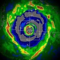
Lekima is approaching 130 kts or upper Cat 4 per ADT#s the past few hours. This cyclone may even become a Cat 5 on Saffir Simpson scale. Of course a reminder that the agency responsible for that region measures in 10-minute sustained averages, but nonetheless the TC is a beast tha lt may be a Super Typhoon near initial brush / land interaction with Ryukyu Islands, Japan, near to Ishagaki.
-
2019 Atlantic Hurricane Season
Windspeed replied to AfewUniversesBelowNormal's topic in Tropical Headquarters
ZCZC MIATWOAT ALL TTAA00 KNHC DDHHMM Tropical Weather Outlook NWS National Hurricane Center Miami FL 800 PM EDT Wed Jul 31 2019 For the North Atlantic...Caribbean Sea and the Gulf of Mexico: 1. An area of disturbed weather stretching from central and eastern Cuba northward to the central and southeastern Bahamas is forecast to move northwestward tonight and Thursday, and then move northward on across Florida and the northwestern Bahamas on Friday. This system is expected to produce locally heavy rainfall over portions of the Greater Antilles, the Bahamas and Florida during the next few days. Conditions could become marginally conducive for development over the weekend while the system turns and accelerates northeastward off the southeastern U.S. coast. * Formation chance through 48 hours...low...near 0 percent. * Formation chance through 5 days...low...10 percent. 2. A broad low pressure system is producing a large area of cloudiness and shower activity several hundred miles west-southwest of the Cabo Verde Islands. Environmental conditions are not expected to be conducive for significant development of this disturbance during the next couple of days while it moves westward at about 15 mph across the central tropical Atlantic Ocean. However, conditions are forecast to become more conducive for development over the weekend, and a tropical depression is likely to form by early next week several hundred miles east of the Lesser Antilles. * Formation chance through 48 hours...low...near 0 percent. * Formation chance through 5 days...high...70 percent. Forecaster Stewart -
2019 Atlantic Hurricane Season
Windspeed replied to AfewUniversesBelowNormal's topic in Tropical Headquarters
Yeah the 12z ECMWF has some very strong 400-300 mb southwesterly winds moving in a line from Cuba across the Bahamas and Bermuda in the 5-7 day range. The GFS is more aligned with the Hudson to Nova Scotia trough and better supportive stacked southerly flow. Hence the GFS has a borderline major hurricane rounding the western periphery of backing 580 dm heights versus the ECMWF which is NOT southerly stacked in flow, which just decapitates any tropical entity that would dare move near the SE CONUS / Bahamas. -
2019 Atlantic Hurricane Season
Windspeed replied to AfewUniversesBelowNormal's topic in Tropical Headquarters
Disturbance near the Cape Verdes is up to 40% for the 5-Day Outlook. ZCZC MIATWOAT ALL TTAA00 KNHC DDHHMM Tropical Weather Outlook NWS National Hurricane Center Miami FL 800 PM EDT Tue Jul 30 2019 For the North Atlantic...Caribbean Sea and the Gulf of Mexico: 1. A tropical wave continues to produce disorganized showers and thunderstorms over Hispaniola, Puerto Rico, and the Virgin Islands. This disturbance is forecast to move west-northwestward to northwestward during the next several days, producing locally heavy rainfall over portions of the northern Caribbean and the Bahamas. Conditions could become marginally conducive for development late this week when the disturbance moves near Florida and the northwestern Bahamas. * Formation chance through 48 hours...low...near 0 percent. * Formation chance through 5 days...low...10 percent. 2. A tropical wave located over the eastern tropical Atlantic, a few hundred miles south-southwest of the Cabo Verde Islands, continues to produce a broad area of disorganized showers and thunderstorms. No significant development of this system is expected for the next few days while it moves westward at about 15 mph. Thereafter, upper-level winds are forecast to gradually become more conducive, and a tropical depression could form over the weekend several hundred miles east of the Lesser Antilles. * Formation chance through 48 hours...low...near 0 percent. * Formation chance through 5 days...medium...40 percent. Forecaster Stewart -
2019 Atlantic Hurricane Season
Windspeed replied to AfewUniversesBelowNormal's topic in Tropical Headquarters
The one very deep wave over interior Africa already has a decent surface low in conjunction to an abundant moisture envelope. The CCKW should still be in place when it emerges into the Atlantic MDR for the first week of August, so we'll have something to watch. However, keep in mind that Azores 500 mb ridging is still kicking in overdrive right now. Though upper level Westerlies have relaxed out of the W. Atl and Caribbean, deep MDR development is still questionable until strong Easterly mid-level flow can relax somewhat. Easterly shear is still a deterrent and it easing will allow SAL to relax, amplifying moisture and convective instability out of the southern ITCZ. -
56°F and feels freaking amazing outside right now. Driving home from work I even turned on the heat. Granted, I had the windows down. Negligible humidity, inhaling that crisp fresh Canadian + radiational cooled air. Premature Fall ejaculation perhaps, but it feels glorious!
- 117 replies
-
- 4
-
-
-
- grieving winter
- hoping for sunshine
- (and 2 more)
-
2019 Atlantic Hurricane Season
Windspeed replied to AfewUniversesBelowNormal's topic in Tropical Headquarters
-
2019 Atlantic Hurricane Season
Windspeed replied to AfewUniversesBelowNormal's topic in Tropical Headquarters
Most if not all of the upwelling occurred in the central and NW GOM. The eastern GOM is still at or above normal. Air temps are running in the mid-to-upper 90s through the end of the month regardless. You are correct in that it won't take very long for the western half of the GOM to rebound for August. -
Central/Western Medium-Long Range Discussion
Windspeed replied to andyhb's topic in Central/Western States
Did not see a recent banter thread so thought I would just post here. This new video by Pecos Hank discussing super computer mesocyclone and tornado genesis with Dr. Leigh Orf is an absolute must watch: -
2019 Atlantic Hurricane Season
Windspeed replied to AfewUniversesBelowNormal's topic in Tropical Headquarters
Even though we are still beyond 72 hrs from a trackable feature, if one does indeed resolve, there are already two different camps between the GFS vs ECMWF runs over the past few days. Though both models do have a sharp surface trough / low pressure system over the SE US & NE GOM, the ECMWF is more aggressive in southern advancement of that boundary and an attached 850-700 mb vortex. Cyclogenesis on the Euro is much further south out over the GOM, versus the GFS runs which keeps the feature either inland or in closer proximity to land. Granted we are still early into in these model runs and confidence should remain low for now. If given a scenario of better modeling agreement on the eventual placement of the surface trough, even with a disturbance positioned out over the GOM doesn't guarantee TC development. That being said, last night's 0z ECMWF was the most aggressive in development so far: -
2019 Atlantic Hurricane Season
Windspeed replied to AfewUniversesBelowNormal's topic in Tropical Headquarters
A boundary is forecast to stall and linger over the north GOM next week. An MCS currently organizing over Kansas may push SSE with the boundary and move off the Panhandle coastline possibly developing a sharp surface trough / area of low pressure, which some of the globals are trying to close off into a tropical or sub tropical cyclone. At least something to watch for development towards the mid-to-late week timeframe. -
Strong storms moved through TYS and MRX but most things have calmed down and seem rather tame at the moment.
-
Tornado warning north of Knoxville. Rotation/strong winds moving towards Maynardville.
-
The SPC did upgrade to a slight risk for much of the eastern TN Valley including an enhanced risk for the northeastern portion.
-
Vanu began a westward drift and should avoid landfall as a strong cyclone. Globals show a westward motion for a few days before eventually getting sheared off. A weaker system may still get pulled via the low level flow into Pakistan/NW India so flooding rainfall may still be a concern in the coming week.
-
Day 1 Outlook Graphic...
-
SPC sticking with marginal for Tennessee and Ohio Valleys. Day 1 Convective Outlook NWS Storm Prediction Center Norman OK 0752 AM CDT Wed Jun 12 2019 Valid 121300Z - 131200Z ...THERE IS A MARGINAL RISK OF SEVERE THUNDERSTORMS ACROSS PARTS OF THE OHIO/TENNESSEE VALLEYS INTO THE SOUTHEAST AND COASTAL CAROLINAS...MISSOURI/ARKANSAS VICINITY...AND WEST TEXAS... ...SUMMARY... Isolated strong to severe thunderstorms will be possible today across parts of the Ohio/Tennessee Valleys into the Southeast and coastal Carolinas, Missouri/Arkansas vicinity, and west Texas. Marginally severe hail and strong/gusty winds should be the main threats. ...Synopsis... For convective purposes, the mid/upper-level pattern will be dominated by a high-amplitude, synoptic-scale trough now located from northwestern ON across the upper Mississippi Valley, to the KS/MO border area and deep south TX. By 12Z, this trough should shift eastward to Lakes Superior and Michigan, IN, middle TN, AL, and the north-central Gulf. Several embedded/minor shortwaves will traverse the associated cyclonic-flow field through the period, contributing to relatively maximized potential convective coverage on the mesoscale. Farther west, a weak shortwave trough will move inland over parts of the Pacific Northwest and northern CA, contributing to locally gusty dry thunderstorms, as noted in the SPC fire-weather outlook. At the surface, 11Z analysis showed a wavy, quasistationary frontal zone from southern SC across central/southern GA, to near the LA coastline, and across deep south TX. This boundary should move little through the day, while becoming more diffuse west of central/eastern GA. Another cold front was drawn from Hudson Bay across northern ON, Lake Superior, to a low near CID, to another weak low near TUL, and finally, to yet another weak low near INK. This front will move eastward/southeastward through the period, reaching lower MI, southern MO, the Arklatex region, and portions of central/southwest TX by 00Z. By 12Z, the approach of the mid/upper trough will induce frontal-low formation over southeastern Lower MI. The cold front will extend from the MI low across eastern TN, southeastern MS, and south-central TX. ...Southeastern CONUS to Ohio Valley... Scattered thunderstorms should develop through this afternoon in an arc of favorable buoyancy and weak CINH, wrapping around the southern/western Appalachians, along and outside of the low-theta-e damming air mass. Isolated severe hail and damaging to marginally severe gusts are possible. The most favorable conditions at various levels for severe will be horizontally displaced from each other across this broad, arching area, but individual elements may contribute to at least marginal severe potential locally. Moisture quality and theta-e will be greatest over the FL/GA/Carolinas swath, while mid/upper flow, cooling aloft, and deep shear will increase northward/northwestward through the western Appalachians/Ohio Valley lobe. Warm and moist advection north of the frontal zone, across western GA and eastern portions of AL/KY, will contribute to destabilization through the afternoon, in tandem with diabatic heating, enabling a narrow corridor of 500-1500 J/kg MLCAPE to develop there. Despite modest midlevel lapse rates, pockets of 1500-2500 J/kg MLCAPE should develop this afternoon in the Southeast. Weak low-level flow is forecast area-wide, except for some hodograph enhancement possible above the surface late afternoon and evening near the Atlantic coastal areas of GA/Carolinas. An assortment of boundaries will focus convection, including the frontal zone, outflow, differential- heating areas, confluence lines in the warm sector, and sea breezes. ...Ozarks and vicinity... Airmass recovery following the morning clouds/convection should become favorable for the next round of thunderstorms -- this time including surface-based cells -- by mid/late afternoon. Seasonably cold, -16 to -18 deg C 500-mb temperatures will spread over this region this afternoon, near the mid/upper-level trough. When juxtaposed with residual boundary-layer moisture, afternoon surface diabatic heating and related strengthening of low/middle-level lapse rates, forecast soundings reasonably suggest around 500-1000 J/kg MLCAPE with little or no MLCINH and a well-mixed subcloud layer. Organization will be tempered by lack of more robust moisture and shear, with little directional shear and effective-shear magnitudes generally less than 30 kt. However, strong anvil-level flow will aid in ventilation aloft, and the most robust cells may offer marginally severe hail/gusts. With convective potential extending northward into much of IA, the northern bound of the marginal risk area is, in reality, much fuzzier than the graphical line indicates, but already low-end severe potential still appears to diminish with northward extent into lesser magnitudes of cloud-layer shear and low-level theta-e. ...TX Big Bend/Trans Pecos... Isolated thunderstorms may develop this afternoon over this region south of the cold front, especially near higher terrain where diabatic heating will erode MLCINH preferentially. Severe hail and strong to marginally severe gusts are possible from any sustained convection that can form, though convective coverage is in question. Low-level convergence will be maximized near the generally southward-moving surface low, and any associated convergence zone extending southward. The main uncertainty involves whether associated lift will be sufficient to form/maintain thunderstorms long enough to produce severe, in an environment characterized by steep low/middle-level lapse rates and adequate boundary-layer moisture. Surface dew points in the mid 50s to low 60s F contribute to potential MLCAPE 1500-2500 J/kg in modified model soundings. In areas south to southeast of the low where an easterly surface wind component will enhance directional shear, 35-45 kt effective-shear magnitudes may be found. Any severe threat in this region should be conditional and short-lived, decreasing markedly after dark. ..Edwards.. 06/12/2019
-
TC Vayu in the NW Indian Ocean / Arabian Sea is forecast to become a Category 2 cyclone in the coming days and make landfall over the NW Indian and Pakistani coastline / borderlands. HWRF is most agressive in intensification making Vayu a Category 4 cyclone. The late track may be quite problematic for significant flash flooding as the cyclone will slow down and drift somewhere between Sindhu (Indus) of Pakistan and Mahi River Valleys.
-
2019 Atlantic Hurricane Season
Windspeed replied to AfewUniversesBelowNormal's topic in Tropical Headquarters
There is a strong MCS along the ITCZ boundary there that is attached to an inverted wave axis stretched back over Guinea and Sierra Leone. There is clearly mid level rotation on visible, but microwave does not show anything at the surface yet. If it persists, not impossible that an MCV/LLC could cutoff at the surface, but it would need to move WNW and break away from the ITCZ boundary. OTOH, if you will glance at the central Atlantic, you will easily notice a very strong and persistent westerly upper level jet out of the Caribbean very typical of this time of year. Anything that would come out of the eastern MDR is going to get shredded until that subtropical jet lifts out. -
Though they kept the graphic marginal, the wording is such that they definitively left the door open for a slight risk to be added tomorrow over the eastern Valley. Perhaps even a small area of enhanced if buoyancy and lapse rates are in line with the sharpening trough. We shall see...
-
Though we needed the rain, this is just too much at once. 4 inches since yesterday and potentially another 2-3 tonight if this southeasterly training maintains into mid AM hours. Edit: Fortunately the persistent heavy downpours tapered off to lighter showers around midnight.
- 117 replies
-
- grieving winter
- hoping for sunshine
- (and 2 more)
-
2019 Atlantic Hurricane Season
Windspeed replied to AfewUniversesBelowNormal's topic in Tropical Headquarters
2019 hurricane forecast & landfall probabilities raised by Colorado State https://www.artemis.bm/news/2019-hurricane-forecast-landfall-probabilities-raised-by-colorado-state/ -
2019 Atlantic Hurricane Season
Windspeed replied to AfewUniversesBelowNormal's topic in Tropical Headquarters
High risk for flooding has been issued today for portions of Texas and Louisiana by the NWS/WPC due to the tropical disturbance over the western GOM. -
2019 Atlantic Hurricane Season
Windspeed replied to AfewUniversesBelowNormal's topic in Tropical Headquarters
Meh, the disturbance in the western GOM probably has degraded from "iffy" to unlikely at this point. There is still disorganized convection and perhaps a broad mid-level low, possibly even weak surface circulation near Brownsville. Despite current trends the HWRF continues to develop a deeper asymmetric tropical storm that gets pulled NNE-NE into LA, but unless the disturbance takes a drastic turn in consolidating convection, I'm giving up expecting anything other than weaker lows merging over ETX and MS Valley. Still significant impacts from severe storms and flash flooding over next 2-5 days to watch from those points, east.