

Windspeed
-
Posts
4,734 -
Joined
-
Last visited
Content Type
Profiles
Blogs
Forums
American Weather
Media Demo
Store
Gallery
Everything posted by Windspeed
-
 Australia now has two intensifying cyclones. Positioned off the NW coast is Veronica, which is quickly consolidating a core and looks to become an intense cyclone in the near term. Likewise, Trevor, which is emerging over the Gulf of Carpentaria is quickly reorganizing after crossing the Cape York Peninsula. Both cyclones are unanimously modeled to become severe cyclones and there is even the possibility of an extremely rare occurrence of two Category 5s raging simultaneously near to the Australian coastline at once.
 -
RE: Idai https://media.ifrc.org/ifrc/press-release/mozambique-cyclone-90-per-cent-beira-surrounds-damaged-destroyed/ https://www.bbc.com/news/world-africa-47609676]https://www.bbc.com/news/world-africa-47609676 https://www.bloomberg.com/news/articles/2019-03-18/mozambique-flood-death-toll-may-be-more-than-1-000-zitamar-says
-
Pretty unanimous global modeling on a sub 930 mb tropical cyclone traversing the Gulf of Carpentaria late week. Looks like double landfalls for Cyclone Trevor in Australia. The initial being eastern Cape York Peninsula coast late on Tuesday. Then reintensification transitioning into rapid intensification as the severe cyclone turns poleward in the Gulf of Carpentaria.
-
This may be a nonstory to you, but the situation is still unfolding. No, it's not like they're just sitting in their homes waiting to drown. But people may be displaced and surged/flooded urban areas, much more rural, are difficult to reach with roads and bridges impassable. The Yatumbe River is currently expanding out across its flood plain with heavy rains continuing to fall over its interior tributaries. What is modeled, an additional 500mm/20 inches on top of what has already fallen, possible through Wednesday. News doesn't exactly flow out to Western media from this part of the world at a rapid pace like it does elsewhere. It's going to take days to weeks for resources to get out all that is happening there to verify what has occurred from a meteorological perspective; and again, a large fraction of those 500k people are currently displaced within ongoing inclement weather, which isn't exactly helping the spread of personal testimony and experiences without anyone able to reach them on the ground and report it. I'm not going to stop posting or apologize for posting about this event regardless if it seems like I am being too dramatic.
-
Their comms infrastructure isn't like that found in the US. And there have been limited resources on the ground relaying out the imagery we are just now seeing above. It was a major hit on a populated area with extreme rainfall totals still accumulating. What's not to be dramatic about? There is very real possibility of significant loss of life and a humanitarian crisis unfolding in the coming weeks/months.
-
Looking at the structural failures in that imagery above, I can only say I hope the residents there evacuated. That looks pretty grim.
-
Images via International Federation of Red Cross:
-
Idai's remnant low continues to sit and spin over Mozambique and Zimbabwe, pulling a strong moisture feed off the Mozambique Channel and Indian Ocean; daytime heating adding to atmospheric instabilty supporting intense convective plumes over the same locations, essentially firehose band precipation moving over the interior. Not to sound dreary, but I would be surprised if conditions in both countries do not escalate into an humanitarian crisis at this point. A trailing surface trough and unstable boundary appears to hold between the highlands and coastal region through Wednesday until Idai's remnant low completely dissipates/precipitates out. On top of what has already fallen, here is the modeled ECMWF totals, the bulk which falls over the next 72 hours:
-
The INGC, Mozambique's governmental natural hazards and disaster mitigation agency is on the ground evaluating damage. There has been very little word out of there.
-
ADT for Idai rebounded somewhat prior to landfall. JTWC dropped to 95 kts on the last advisory. However, the core may have regained some of that intensity as cloudtops cooled and the eye appeared less ragged. Though 95 or 105 kts isn't a huge difference, increasing convection in the eyewall versus eroding convection may have helped transport destructive gusts to surface.
-
Mesoscale Discussion 0208 NWS Storm Prediction Center Norman OK 1147 AM CDT Thu Mar 14 2019 Areas affected...Northeast Mississippi...Northwest Alabama...and southern Tennessee Concerning...Severe potential...Tornado Watch likely Valid 141647Z - 141815Z Probability of Watch Issuance...80 percent SUMMARY...A gradual increase in storms is expected through the afternoon. A tornado watch will likely be needed soon. DISCUSSION...16Z surface analysis shows much of northeast Mississippi and northwest Alabama has warmed 4 to 5 F in the last hour despite some cloud cover across the area. This has led to an increase in low-level instability to around 750 to 1000 J/kg of MLCAPE. Warming is expected to continue with low-level moisture advection which will lead to moderate instability by mid-afternoon. The recent heating in this area has provided enough instability for a reinvigoration of lightning from some of the convection in northern Mississippi. Therefore, expect more widespread storm coverage within the next hour or two as surface destabilization continues to increase. Deep-layer shear in this area is very favorable for supercell and low-level mesocyclone development with deep layer effective shear around 55 to 60 knots and 0-1 SRH around 350 m2/s2 per GWX VWP. Therefore, these storms will pose a tornado threat with the potential for strong tornadoes, especially as supercells mature into northwest Alabama. ..Bentley/Thompson.. 03/14/2019
-
Cyclone Idai, moving across the Mozambique Channel has completed an ERC and slightly reintensified to Cat 3. The internal structure of the cyclone has taken on annular characteristics. It is forecast to make landfall near the city of Beira in Mozambique. Despite Idai's intensity, flash flooding will be the greatest threat to the city and surrounding region. Certainly storm surge up the Pungwe River also poses a dangerous threat to life and property.
-
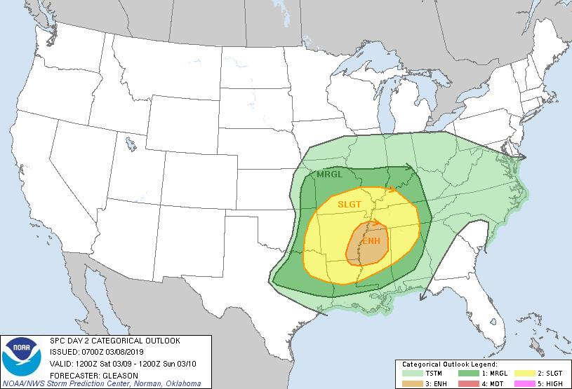
SPC AC 080700 Day 2 Convective Outlook NWS Storm Prediction Center Norman OK 0100 AM CST Fri Mar 08 2019 Valid 091200Z - 101200Z ...THERE IS AN ENHANCED RISK OF SEVERE THUNDERSTORMS ACROSS PARTS OF THE ARKLAMISS INTO NORTHERN MS AND SOUTHWESTERN TN... ...SUMMARY... Severe thunderstorms may occur Saturday from parts of eastern Oklahoma and Texas into the lower/mid Mississippi Valleys, lower Ohio Valley, and Southeast. The best potential for scattered damaging winds and a few tornadoes appears to be across parts of the ArkLaMiss into northern Mississippi and southwestern Tennessee. A couple of these tornadoes could be strong. ...Synopsis... A negatively tilted shortwave trough initially over the southern and central Plains will move rapidly northeastward to the Upper Midwest, Great Lakes, and OH Valley regions by Saturday evening. An associated surface low over central KS should develop northeastward in the same time frame to the vicinity of eastern IA/northern IL while deepening slightly. A cold front attendant to this surface low will sweep eastward across much of the lower/mid MS Valley into the lower OH Valley and Mid-South through the day. The trailing portion of this front should stall over parts of the Southeast Saturday night as this boundary becomes increasingly aligned parallel to the mid-level flow. ...East TX/OK into the Lower/Mid MS Valleys, lower OH Valley, TN Valley, and Southeast... Increasing ascent associated with the approaching shortwave trough and a strengthening low-level jet will likely foster an increase in convective coverage and intensity across parts of eastern OK/TX into the ArkLaTex region early Saturday morning. These thunderstorms will have some potential to be surface-based, especially along and south I-40 in central AR where surface dewpoints should reach into the mid 60s to the south of a warm front. A couple tornadoes and isolated damaging winds should be the main threat given the strong low-level shear that will be present, although some large hail could also occur as far northward as the Ozarks in southern MO with any elevated supercells that develop. The main uncertainty regarding the overall magnitude of the severe threat across the lower MS Valley into the Mid South remains the northward extent of potential destabilization. The early morning convection should move quickly east-northeastward in tandem with the low-level jet and surface cold front. It appears that a greater chance for surface-based thunderstorms should occur from parts of the ArkLaMiss region into northern MS and southwestern TN from late Saturday morning into the early afternoon, where MLCAPE of 500-1000 J/kg could develop. Low-level shear is forecast to be very strong through 18-21Z as a 50-65 kt southwesterly low-level jet overlies this region. Forecast soundings show ample effective SRH to support rotating updrafts, and a few tornadoes could occur, particularly if convection can remain semi-discrete. There is some concern that a couple of these tornadoes could be strong given the very favorable kinematic environment. Scattered damaging winds may also be possible across this region. By late afternoon into the evening, the shortwave trough and strongest mid-level flow will become increasingly displaced to the north of the greater low-level moisture across the TN Valley and Southeast. Still, some severe threat may persist into parts of middle TN and northern/central AL. Farther north into the mid MS Valley and lower OH Valley, confidence in sufficient destabilization to support surface-based convection is even more questionable. Regardless, there will be very strong low- and mid-level flow present which could support isolated damaging winds and perhaps a tornado. This threat should wane with eastward extent across southern IN and central KY by Saturday evening as low-level moisture and related instability become increasingly marginal. ...MAXIMUM RISK BY HAZARD... Tornado: 10% SIG - Enhanced Wind: 30% - Enhanced Hail: 15% - Slight ..Gleason.. 03/08/2019 CLICK TO GET WUUS02 PTSDY2 PRODUCT NOTE: THE NEXT DAY 2 OUTLOOK IS SCHEDULED BY 1730Z CURRENT UTC TIME: 0928Z (4:28AM), RELOAD THIS PAGE TO UPDATE THE TIME
-
Unfortunately today's event is already the deadliest tornado outbreak since the April 27th-28th outbreak in 2014. I believe there were 34 deaths as a result of that event, though that outbreak covered a much larger region of the country. Of course it only takes one strong EF3+ tornado tracking through a residential area to have a significant number of deaths. The toll in Lee County, Ala. alone stands at 22 and may rise further unfortunately. Datasets located here: http://spc.noaa.gov/climo/torn/fatalmap.php
-
I know it's not our area, but portions of Alabama and southern GA are getting rocked this evening. Significant long track tornadoes, some strong and some unfortunately deadly with multiple fatalities. https://www.americanwx.com/bb/topic/52142-march-3-2019-severe-threat/
-
TN valley heavy rain/flooding week of whenever
Windspeed replied to janetjanet998's topic in Tennessee Valley
Yeah today hurt. I am thankful we got a 72-96 hour break this week, but I thought today's rain would remain light and rather insignificant. Nope, a rather large area will finish around .8 to 1.25 for the upper TVA watershed. -
TN valley heavy rain/flooding week of whenever
Windspeed replied to janetjanet998's topic in Tennessee Valley
Same video but on KnoxNews Sentinel's YT channel: -
The Columbus, MS tornado has been rated an EF3.
-
Super Typhoon Wutip was upgraded to Cat 5. No, not unusual to see those in the WPAC, but it's a first for February. In fact, this is the first classified Cat 5 ever in the northern hemisphere for the month. 28°C SSTs around the Marinas are still warm enough to support the intensity, but atmospheric favorability and outflow for this cyclone is textbook.
-
That site is cancer on mobile. Full of spam and redirects.
-
Got an engagement and won't be able to post further warnings but it does look like things are picking up. Hopefully things don't digress into an outbreak and the discrete stuff transitions more linear swifly. Regardless, good luck to everyone. Here is the most recent warning on cell east of Philadelphia, MS, moving ENE:
-
Well-defined quasi-linear meso circulation on the strong line approaching MS/AL line moving north of Aberdeen, MS.
-
Discrete cells over central MS starting to get that look.
-
West of Booneville, MS:
-
First tornado warning of the event issued in Walker Co., Alabama:


