-
Posts
4,734 -
Joined
-
Last visited
Content Type
Profiles
Blogs
Forums
American Weather
Media Demo
Store
Gallery
Everything posted by Windspeed
-
Looks like the WPAC is going to produce our first and perhaps only Cat 5 of 2020. Goni has become intense. Edit: Ugh... This year. I completely forgot about Amphan and Harold. So yes, this makes the third Cat 5.
-
If this goes bonkers in the central Caribbean, it may leave the door open for the GOM. Upper mid-level flow would be more ESErly for a WNW track if a stronger stacked hurricane. This could be another Yucatán strike and then depending on downstream wave/trough interaction, could lift poleward. But obviously it's too early. But a weaker system would seem more likely a Nicaraguan/Honduras threat. A stronger hurricane a Belize/Yucatán/GOM threat.
-
Radar out of Martinique.
-
Here we go again. Newly designated Invest 96L is already showing signs of further development tonight in the Lesser Antilles with strong southerly banding trying to close off a mid-level vortex. Too early to know if a surface circulation is forming, but clearly the disturbance is organizing. If TCG is ahead of schedule it could really open the door for a hurricane, perhaps a major by the time this moves into the Western Caribbean. Going ahead and firing up a thread due to land interaction and an obvious up in genesis progs. A large area of disturbed weather in the vicinity of the Lesser Antilles is associated with a tropical wave. Upper-level winds are expected to become more conducive for development of this disturbance during the next few days, and a tropical depression is likely to form by the time the system reaches the western Caribbean Sea early next week. * Formation chance through 48 hours...low...30 percent. * Formation chance through 5 days...high...70 percent.
-
This persistent flare-up of deep convection has a clear linear band on the east side of the wave axis. That boundary is southerly. That needs to be closely watched as it would not take much for convergence to develop a low-level vortex. This is clearly going to close off a mid-level vortex within the tiny MCS even if temporary. TCG could happen way before initially expected which would open up a plethora of forecasting possibilities. This would immediately become a long-tracking TC through a favorable Caribbean with very high OHC.
-
Streams are up but nothing too major. Upper NE TN/SW VA faired pretty well. All the high wind remained east of the Blue Ridge or ridges and peaks above 3600 ft. Generally the stronger stuff clipped Chattanooga but shot east through the Carolinas to SE VA. As for rain, here's a clip of the West Prong of the Little Pigeon from Gatlinburg, TN.
-
New invest does have some disorganized but building convection along the wave axis. It's not much for now but this does seem to have potential over the weekend in the central Caribbean. It's moving slow enough that strong enough consolidated convection could fold or close off a surface vortex.
-
Most recent outlook from the NHC... A large area of disturbed weather moving from the tropical Atlantic across the Lesser Antilles and into the eastern Caribbean Sea is associated with a pair of tropical waves. Upper-level winds are expected to become more conducive for development of this disturbance during the next couple of days, and a tropical depression could form over the weekend or early next week while the system moves westward across the central and western Caribbean Sea. * Formation chance through 48 hours...low...20 percent. * Formation chance through 5 days...medium...60 percent.
-
Screaming low-level jet influenced by the strong trough. I'd say the dry slot may pack a punch well after the precipitating core has move away.
-
Well that's a rare sight..
- 508 replies
-
- 14
-

-
Couldn't resist posting this...
-
Crazy amount of couplets with this hurricane.
-
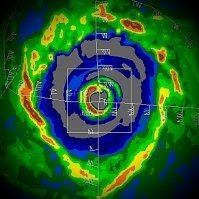
Even for a halfcane, Zeta has an impressive eyewall. New Orleans metro is about to get smacked.
-
Could be waiting on new dropsonde data. But it probably won't be enough.
-
Potential severe impacts far inland it seems...
-
It may be semantics, but someone is going to get hit hard by this hurricane. It's definitely NOT a weakening junk storm falling apart at landfall like I thought it would be.
-
Looks like they are going for a SE to NW pass. We should know definitively whether or not this has reached MH status prior to landfall.
-
Sheesh...


.png.e55636977efceb792339128438a0449a.png)
.png.ff79a539ac1d03117e289126b4bc55dc.png)

