

Windspeed
-
Posts
4,741 -
Joined
-
Last visited
Content Type
Profiles
Blogs
Forums
American Weather
Media Demo
Store
Gallery
Everything posted by Windspeed
-
Convection slowly increasing around the center.
-
This landslide in Guatemala took out an estimated 75 homes.
-
Invest 97L looks close to getting named. The bottom half of the surface circulation looks to be contracting, aligning under the robust mid-level circulation and convection. This looks like an STC now.
-
Seems reasonable. Interestingly the 06z HWRF has come in much weaker and disorganized versus all the previous runs that wanted Eta to experience another round of robust intensification. It figures. lol... We'll see if the NHC begins to back off reintensification to a hurricane on the next advisory. I doubt it based on one factor of guidance. As for track, it still makes more sense that the vortex either eventually makes landfall along the Panhandle to Big Bend area or gets sheared off and degenerates into remnant low along the NGOM coast by the incoming CONUS trough. The 06 HWRF also does move the system more west which would subject it to a harsher environment.
-
Eta is now moving SSW. Though it looks pretty anemic thanks to very stable dry air out of the west being pulled in by the mid-to-upper trough/ULL, there is still a good stream of moisture feed out of the Caribbean on the backside. As Eta continues to dive SSW today, robust convection will likely begin to weaken the ULL due to diabetic heating. As such a small anticyclone should begin to form over Eta to further aid in divergence. Dry air may have less of an influence without the mid-level flow infringing upon Eta's vortex. If convection can ramp up this evening, it should be able to close off and shield itself somewhat from the mid-level influences of dry air and shear. This has been modeled consistently by the HWRF, which continues to want to ramp Eta back up into a hurricane. How strong a hurricane will likely depend on how far SSW the vorticity maximum can get by tonight, how long it persists there over the Gulf Loop (which is still very warm at the surface - 29ºC), and how fast the ULL can be filled by Eta's convective influences.
-
Fairly impressive structure to have crossed Cuba. It did seem to straddle between the higher terrain but the western semicircle of the low level vortex did cross over mountains. Still, the core looks intact. We'll see how this translates to strengthening today. There is still moderate shear.
-
HWRF now gets Eta down to 960 mb in the EGOM. This is likely due to Eta remaining SE of strong mid level southwesterlies for a longer duration and also over the GS loop current as well. Not sure if it will make a run at Cat 3 but such modeling does hint at how Eta could become a formidable hurricane again. That being said, there isn't enough atmospheric support or OHC in the NE GOM for it to maintain such an intensity. Beyond cooler SSTs, it would eventually succumb to shear W or WNW of Tampa.
-
Sheared? Yes. Still, not looking too shabby for a TS at the moment. Impressive bursts of lightning over the past hour. Eta is trying to find itself a hurricane again.
-
Eta still has a sheared assymetric presentation on radar.
-
Upper level reconnaissance mission did find pretty significant westerly mid level shear. Not unexpected. It should be enough to prevent rapid intensification from occurring in Eta. But with strong divergence aloft, there could be enough atmospheric support to allow continued slow strengthening through Cuban landfall.
-
Definite improvement this morning.
-
Starting to get some mid-level core alignment under nice convection. Perhaps even an LLC reformation has occurred. Might have downplayed potential impacts in Cuba too swiftly.
-
Heh... MJO phases in late Nov.- early Dec. looking highly supportive for a interesting close and even prolonged potential Caribbean activity.
-
Visible since daybreak...
-
-
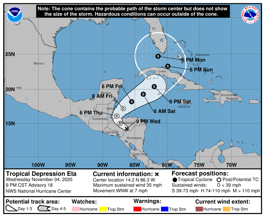
000 WTNT44 KNHC 050238 TCDAT4 Tropical Depression Eta Discussion Number 18 NWS National Hurricane Center Miami FL AL292020 900 PM CST Wed Nov 04 2020 The rugged terrain of Central America is taking a toll on Eta. The low-level circulation is losing definition, and deep convection is well removed from the center. Eta was downgraded to a 30-kt tropical depression a few hours ago, and the initial intensity is held at that value for this advisory. The strongest winds are likely occurring offshore over the Gulf of Honduras, as noted in earlier ASCAT scatterometer surface wind data. Eta, or its remnant low, is forecast to move west-northwestward to northwestward during the next 12 to 24 hours, taking the cyclone across portions of Honduras during that time. In 24 to 36 hours, a turn to the north and then northeast is forecast as Eta feels some influence from a mid- to upper level trough moving over the northwestern Gulf of Mexico. As this trough slides southeastward across the Gulf, it should steer Eta northeastward at a faster forward speed toward Cuba, likely approaching that country late Saturday or Sunday. After that time, the models show Eta rotating around the north side of the trough (or cut-off low) in the vicinity of south Florida and the Florida Keys late this weekend and early next week. There is still a lot of spread in the model tracks at the 96- and 120-hour time periods, which is not surprising given the expected complex steering pattern. The NHC track forecast is adjusted a little to the east of the previous one to come into better agreement with the latest models, but confidence in the details of the extended track forecast is low. Continued weakening is expected while Eta remains inland over the rugged terrain of Central America, and the cyclone will likely degenerate into a remnant low or trough of low pressure on Thursday. Whatever is left of Eta, and the broad gyre that it is embedded within, will move offshore of Belize over the northwestern Caribbean Sea by Thursday night or Friday. The rate of intensification over the northwestern Caribbean Sea will likely be gradual because of the mixed environmental conditions. On one hand, Eta will be moving over warm water and in a region of upper-level diffluence, which should support convective growth and strengthening. Conversely, there will also be an increase in wind shear and the cyclone is likely to have a broad structure, which should prevent rapid intensification. The net result will likely be slow but steady strengthening, and Eta is forecast to be a strong tropical storm when it is near south Florida. The models are in fair agreement on Eta's future intensity, and this forecast is just a little higher than the previous one. Key Messages: 1. Through Monday morning, heavy rainfall from Eta will lead to catastrophic, life-threatening flash flooding and river flooding across portions of Central America, along with landslides in areas of higher terrain. Flash and river flooding is also possible across Jamaica, southeast Mexico, the Cayman Islands and western Cuba. 2. Eta is forecast to regain tropical storm strength over the northwestern Caribbean Sea late this week. Although the details of the future track and intensity of Eta are uncertain, there is an increasing risk of impacts from wind and rainfall in portions of Cuba, southern Florida and the Florida Keys this weekend and early next week. FORECAST POSITIONS AND MAX WINDS INIT 05/0300Z 14.2N 86.3W 30 KT 35 MPH...INLAND 12H 05/1200Z 15.0N 87.3W 25 KT 30 MPH...POST-TROP/REMNT LOW 24H 06/0000Z 16.1N 87.8W 25 KT 30 MPH...POST-TROP/REMNT LOW 36H 06/1200Z 17.2N 86.8W 30 KT 35 MPH...POST-TROP/REMNT LOW 48H 07/0000Z 18.2N 85.5W 35 KT 40 MPH...TROPICAL CYCLONE 60H 07/1200Z 19.3N 83.7W 40 KT 45 MPH 72H 08/0000Z 20.4N 82.0W 45 KT 50 MPH 96H 09/0000Z 23.3N 79.9W 50 KT 60 MPH 120H 10/0000Z 24.7N 81.4W 55 KT 65 MPH $$ Forecaster Cangialosi
-
lol at the 18z GFS. Though that would get us over 170 ACE for the season. [emoji2357]
-
Nicaragua is getting pummeled.
-
We usually leave the highest intensity at landfall in the topic for discussion, but since Eta is likely to regenerate by this weekend, I am going to update the title to current status for future restrengthening.
-
It's not crossing into a new basin. Just like an LLC degenerating into an open wave and then reclosing/generating back into a TC, or a PT/ET reacquiring warm core characteristics, it will retain the name. Examples being Harvey, Paulette, etc. If Eta's remnant low/gyre redevelops into a TC in the NW Caribbean, it will retain the name. Beyond remnants crossing into a new basin, examples of when a name wouldn't be retained are if a remnant TC low gets absorbed or phased with an ET or mid-latitudinal frontal low, or a TC develops out of a new surface low within a lingering frontal boundary, as has occurred off the US eastern seaboard with some GOM landfalls.
-
Definitely an improving satellite presentation before landfall.
-
That last vortex message was a little concerning. Closed eyewall at 8nm. It's over a shallow shelf, not sure if upwelling or participitable cooling could bring down shallow SSTs fast, but it leaves the door open for some possible restrengthening if it lingers too long off the coast. Might just hold its own through landfall, but we'll have to see if the satellite presentation responds and the eye can clear out. New outer band could also reinstate another ERC just as well too.
-
Last 12 hours of motion and fixes have been an absolute crawl. It may pick up westward motion but it sure is slow enough to cause some uncertainty and put down some insane rainfall totals.
-
Classic and mature ERC this morning prior to landfall.
-
Eta may very well not get upgraded though it's borderline right now. Eventually time is going to run out. Either way, definitely the best looking Atlantic hurricane for 2020. Now beyond the semantics before I fall over. Unfortunately an awful scenario for Nicaragua. Eta is now making a beeline for the most populated city in that region, Puerto Cabezus. Then it moves on into higher terrain and dumps insane amounts of rainfall over the next 72 hours.


