-
Posts
4,734 -
Joined
-
Last visited
Content Type
Profiles
Blogs
Forums
American Weather
Media Demo
Store
Gallery
Everything posted by Windspeed
-
-
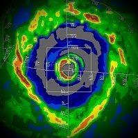
Radar has some suspicious banding that may be trying to consolidate a core. That feature is only barely coming unto view. This may still only be a mid level displaced circulation from the low level center however. So yes, reiterating recon's importance. But there is no doubt Grace looks improved over yesterday. See red X..
-
Major Hurricane Linda has reached Category 4 intensity at 130 mph per latest advisory. I don't expect it to get much stronger. It has likely maxed out its potential for now.
-
Little suspicious that strong MCS/CDO feature is outrunning the broader low level circulation versus aligning over it. Easterly mid level steering flow appears to still be stronger than low level steering flow. We'll have a much clearer picture when recon gets out there of course.
-
Strong earthquake just hit Haiti. With all the heavy rain there, that's not good. Hopefully any landslides that may've occurred were minimal.
-
Taking into account parallax from satellite viewpoint, Clarion Island was entirely within Linda's eye earlier this morning. The last report from the there was a 106 mph gust reported within the NHC's 3AM MDT advisory.
-
-
Hurricane Linda in the EPAC looks like its entering a period of RI. This may really go nuts over the next 24 hours. If this seems eerily familiar, that's because the name Linda is synonymous with powerful EPAC hurricanes. 1997 Major Hurricane Linda reached Category 5 intensity and is eclipsed only by Patricia as the most powerful EPAC hurricane on record. The name did not get retired despite the achievement and impacts on Socorro Island however. It nearly made landfall there and destroyed infrastructure without killing anyone fortunately. This year's Linda likely will not reach its predecessor's lofty status, but Category 4 cannot be ruled out here. This is clearly bombing.
-
Please take these maps with a grain of salt. The rapid intensification of what would potentially be Grace off the SE coast is a result of a very dynamic and favorable upper environment that the GFS evolves around 200 hrs. Again, this is way too far out and therefore this may not pan out at all. But obviously that's some crazy ventilation on the backside of a TC that bends back to the NW late in the run. No wonder the GFS is bombing out the hurricane into landfall.
-
Fred is in a very difficult position for forecast intensity. The upper level low/trough over the eastern GOM could make its life horrible or could act as a prime ventilation feature depending on how fast it retrogrades in a westerly vector. Fred could still out perform model guidance. It could also remain weak. If this were to end up a hurricane, I imagine it would still be a surprise, but I honestly have no bearing on what it will or will not do at this point.
-
2021 Atlantic Hurricane season
Windspeed replied to StormchaserChuck!'s topic in Tropical Headquarters
It's August 12th, dude. Also, the suppressive phase you keep referring to for September is only a possibility and likely would not last more than a few weeks over the WATL. The West African Monsoonal circulation will likely still have sufficient atmospheric favorability during that period in place regardless. Which means any strong AEW could still develop. But again, any month in advance for MJO and you're trying to bank that against peak climo around the second week of Sept. In that respect, you're likely going to lose at those odds unless the overall seasonal trends are inactive and downward. They do not appear to be; and EVEN if September experiences a longer than normal period of inactivity, that's almost three weeks away while MJO would hypothetically remain favorable. -

2021 Atlantic Hurricane season
Windspeed replied to StormchaserChuck!'s topic in Tropical Headquarters
There may be a closed low-level vortex forming along 95L's northern axis. Convection is not that impressive and there are mid level easterlies advecting stable air mass into that complex. Convection needs to persist there if this gets classified sooner than later. It appears to be trying however. -
The weak circulation above is at the 850 mb level. The other recon mission is finding nothing more than a weak trough at a flight level of 12k ft. Unless convection ramps up in relatively short order, Fred will degenerate into an open wave. Hispaniola apparently did not take kindly to its reputation being tarnished in 2020.
-
Fred is on life support.
-
Misaligned centers and crossing Hispaniola is a bad setup for any TC. A number of possibilities here all with regards to a weak cyclone. Everything from surface vort reformation to system dissipation. Laura did remarkably well traversing the mountainous terrain. Isaias fared okay with a center reformation. Many systems do not fare well however.
-

2021 Atlantic Hurricane season
Windspeed replied to StormchaserChuck!'s topic in Tropical Headquarters
If it means you'll stop posting 192 hr garbage maps from operational runs, I'll let you cancel the season right now.- 967 replies
-
- 10
-

-

-

-
Hrmm... There MAY be a surface circulation forming north of the older sharper axis boundary to the south, which had weak mid level cyclonic rotation. Banding is definitely getting strong there and orienting in a W to E flow, even if subtle. Something to watch.
-

2021 Atlantic Hurricane season
Windspeed replied to StormchaserChuck!'s topic in Tropical Headquarters
Yeah it appears things are really heating up. -

2021 Atlantic Hurricane season
Windspeed replied to StormchaserChuck!'s topic in Tropical Headquarters
The AEW south of the Cabo Verdes is healthy and should be watched closely for early development. It looks to be gaining organization as there is clearly some decent mid level cyclonic rotation. This has a chance to become our first pure Cape Verde long-tracking hurricane of 2021 as it tracks W into the MDR. The model support has already been established. -
You can have orographic uplift to assist in condensing water vapor. So yes, it can assist in cell development and even convection within the cyclone. However, high mountainous terrain will impede airflow circulating the core low level vortex at sea level. Too much interaction and the tropical cyclone can get disrupted and fall apart. Sometimes the mid level vortex will be intense enough to help regenerate the surface vortex and sometimes the TC never recovers. It is speculation whether weaker systems handle a large mountainous island such as Hispaniola better than intense systems. There are enough examples of both hurricanes and tropical storms getting ripped to shreds. Likewise there are examples of each surviving and going on to reintensify. Perhaps it is a combination of both mountainous interaction and the present state of vertical wind shear + stable airmass near the core circulation. At any rate, most tropical cyclones do not fare well while over Hispaniola, regardless of their eventual outcome. All this being said, there may be some connection to tropical cyclone genesis and the forcing of surface low development on the Lee side of island mountainous terrain. Perhaps some subtle assistance as developing systems pass through the Lesser Antilles. Further research may be needed there. But this is more for the formation/ developmental phase of TCG, not a well-developed cyclone.
-
You are not fooling anyone. Stop creating accounts just to derail threads.
-
-
No joke. There is hardly a detectable couplet north of Malta.
-
This may be the one caveat for PTC that do not yet have a fully closed circulation. The initial advisory track is susceptible to greater error as the low could close off a good distance away from the invest plot. But nothing is perfect and we need the lead time watches/warnings that PTC advisories provide. That being said, future TS track could be further north. PR may get a direct hit here. Let's hope intensification is slow before the window of favorable upper level winds closes.
-
These new towers going up within southerly flow on the backside of PTC 6 are no joke. This is what we have been waiting to unfold. Previous convection has been very marginal. The current towers are clearly arcing around the northern periphery of the wave axis. This should allow pressures to fall and close the surface low circulation off in relatively short order. PTC was a good call as we may have a classified cyclone by 11 AST.

