Windspeed
-
Posts
4,741 -
Joined
-
Last visited
Content Type
Profiles
Blogs
Forums
American Weather
Media Demo
Store
Gallery
Everything posted by Windspeed
-
No, it is 100% misleading and unwarranted if you understand that model's purpose and use. Yet you still posted it. This is on you. Period.
-
Oh I am, I just will never understand. I can get people who simply do not know better. But to basically disclaimer it and then post? Grrr...
-
Then for God's sake, why post it? Just, why? For all the reasons x10000000, why post the bloody damn NAM, take it seriously and comment about it? Why do people continue to do this?
-
You will rarely get a better (or worse in perspective) synoptic setup like this for a NW moving major hurricane in the Gulf. The hype is warranted. The hope is hitting rural swamps. Hype away and hope for the best.
-
I meant diabatic heating. Sorry, been a long day.
-
Yes, it's very possible recon samples wind data for a tropical storm northeast of the low level circulation. We'll see..
-
An excellent example of why ATCF should not be used over an official advisory. Though Best Track had TD9 as a TS, recon was not convincing enough for the NHC. Therefore, they did not upgrade the depression for the 5PM EDT advisory package.
-
PV / upper trough that brought you storms last night is the culprit. 500-300 hPa level weakness in the ridge north of the TC. A more stacked and strong system will feel the poleward mid-to-upper flow versus a weaker system until 500 dm heights rebuild off the SECONUS and diabetic heating from Ida fills/squashes the PV. A gradual bend back NW is probable into landfall as the potential hurricane traverses the central GOM.
-
I'd imagine the direction of approach is worse for surge and flooding. But it's still not a scenario in stone. Obviously intensity, size, forward motion / speed, fetch while over the central GOM. We can go on....
-
Exactly. Additonally, please take the gloom and doom posts to the banter thread. Too much uncertainty to be making posts like these three days out. If it comes to pass a worst case scenario is unfolding, there will be plenty of gloom to be had. Again, for now there's just too many unknowns.
-
Per ATCF best track, TD9 has now become Ida. AL, 09, 2021082618, BEST, 0, 177N, 794W, 35, 1004, TS, 34, NEQ, 60, 40, 0, 0, 1009, 150, 50, 0, 0, L, 0, , 0, 0, NINE, M,
-
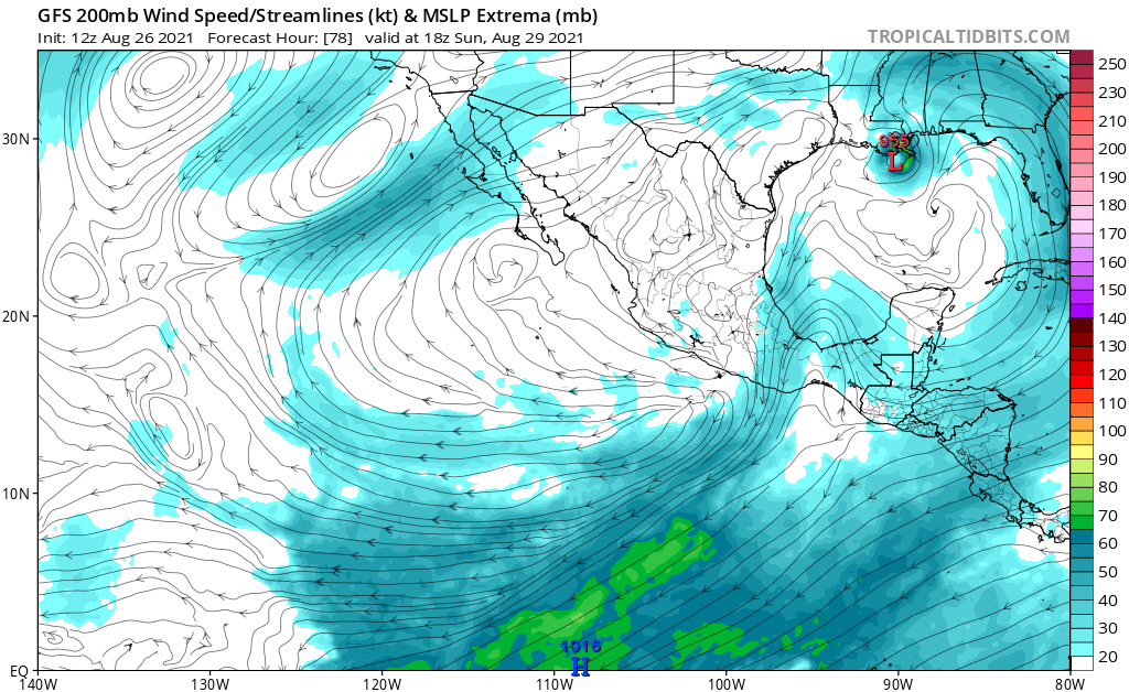
Interesting that the 12z GFS is now lifting Tropical Storm Nora in the EPAC into the Mexican coastline and dissipates by 54 hours. This would be around noon Saturday. Again, this is just one global model solution; however, if there were going to be downstream upper level influences between the potential GOM hurricane, the decaying PV feature over the western GOM and the upper outflow pattern that would have a detrimental impact on TC intensity, you would at least want a strong EPAC TC near the Baja. By 78 hours, the GOM TC is bearing down on landfall with limited interference from upper level westerly flow. The ECMWF may have a completely different outcome for Nora than the 12z GFS, but it is an interesting development. Further still, the decaying PV feature leading into this may be wedged enough in-between Nora and future-Ida for Nora's presence/intensity to not even matter.
-
AF301/TEAL71 has taken off and is en route to TD9.
-
Yuck...
-
We have a potential intense TC brewing that is locked into a US coastal landfall and is about to get a lot of attention, media or otherwise. The main meteorological thread is going to get busy, so as to better assist the mods, we'll make a banter thread here. Ramble on about whatever local concerns, travel, direct, indirect, semi- or even non-related discussion while this event unfolds.
-
I reckon this is the most intensification in an initial advisory I can recall aside from Iota last year. This forecast essentially ties that one. 35 kts to 95 kts in 72 hours. I suppose it's warranted based on all the available data, empirical and simulated. Now just to wait and see what recon finds.
-
Here is the 11AM EDT Discussion for posterity... 044 WTNT44 KNHC 261456 TCDAT4 Tropical Depression Nine Discussion Number 1 NWS National Hurricane Center Miami FL AL092021 1100 AM EDT Thu Aug 26 2021 Early morning visible satellite imagery shows that the circulation associated with the area of low pressure over west-central Caribbean Sea has become better defined. There has also been an increase in the organization of the associated convective activity, and based on consensus Dvorak T-numbers of 2.0 from TAFB and SAB, advisories are being initiated on a tropical depression. The initial intensity is set at 30 kt, in agreement with the subjective satellite estimates. The official reporting station in Kingston, Jamaica, has reported sustained winds of 25 kt with gusts to 35 kt during the past couple of hours. An Air Force Reserve reconnaissance aircraft is scheduled to be in the system later this afternoon to provide more information on the system's structure and intensity. The depression is moving northwestward or 325/11 kt, however the initial motion is a bit more uncertain than normal since the low- level center has only recently formed. The cyclone is forecast to move steadily northwestward around the southwestern portion of a deep-layer ridge centered over the western Atlantic. This track should bring the center near or over western Cuba late Friday, over the southeastern and central Gulf of Mexico Friday night and Saturday, and have the center approach the northern Gulf coast on Sunday. The track guidance is in relatively good agreement, however the average NHC track forecast error at day 4 is around 175 miles, so users should not focus on the details of the long range track forecast. Some shifts in the track are likely until the system consolidates and becomes better defined. The NHC track is near the various consensus model aids and is in best agreement with the GFS ensemble mean. The depression will be moving over the high ocean heat content waters of the northwestern Caribbean Sea during the next 24-36 hours. This, in combination with low vertical wind shear and a moist environment, should allow for steady strengthening. The depression is forecast to become a tropical storm later today or tonight, and could approach hurricane strength as it passes near or over western Cuba. Once the system moves into the Gulf of Mexico, conditions are expected to be conducive for additional strengthening, and rapid intensification is explicitly shown in the NHC forecast between 48 and 72 hours. The NHC intensity forecast brings the system near major hurricane strength when it approaches the northern Gulf coast on Sunday. This forecast is supported by the HWRF and CTCI models, and the GFS, ECMWF, and UKMET global model guidance, which all significantly deepen the cyclone over the Gulf of Mexico. As a result, there is higher-than-normal confidence that a strengthening tropical cyclone will be moving over the Gulf this weekend. Key Messages: 1. Tropical storm conditions are likely in portions of the Cayman Islands tonight and western Cuba Friday and Friday night, with dangerous storm surge possible in portions of western Cuba, including the Isle of Youth, in areas of onshore flow. 2. The system is expected to produce life-threatening heavy rains, flash flooding and mudslides across Jamaica, the Cayman Islands, western Cuba, including the Isle of Youth and northeastern portions of the Yucatan Peninsula. 3. This system is forecast to approach the northern Gulf Coast at or near major hurricane intensity on Sunday, although the forecast uncertainty is larger than usual since the system is just forming. There is a risk of life-threatening storm surge, damaging hurricane-force winds, and heavy rainfall Sunday and Monday along the northern Gulf Coast from the Florida Panhandle to the upper Texas coast, with the greatest risk along the coast of Louisiana. Interests in these areas should closely monitor the progress of this system and ensure they have their hurricane plan in place. FORECAST POSITIONS AND MAX WINDS INIT 26/1500Z 16.9N 79.2W 30 KT 35 MPH 12H 27/0000Z 18.2N 80.4W 35 KT 40 MPH 24H 27/1200Z 20.3N 82.0W 45 KT 50 MPH 36H 28/0000Z 22.5N 83.9W 55 KT 65 MPH...INLAND 48H 28/1200Z 24.4N 86.0W 65 KT 75 MPH...OVER WATER 60H 29/0000Z 26.1N 88.1W 80 KT 90 MPH 72H 29/1200Z 27.7N 90.0W 95 KT 110 MPH 96H 30/1200Z 30.5N 92.0W 70 KT 80 MPH...INLAND 120H 31/1200Z 33.7N 91.2W 30 KT 35 MPH...INLAND $$ Forecaster Brown
-
Unfortunately another landfall under darkness.....
-
Suspicious low-level circulation evident on visible. NHC must have sniffed out something just SW of Jamaica for TD vs PTC advisories. We'll know more soon enough.
-
Agreed, even more complicated now by the societal state in the wake of a pandemic, when many have yet been reluctant to travel. There is a mental barrier for some to overcome. It's a tough decision regardless if you live in a rural or urban area.
-
96 hrs / 4 days... Very little lead time. Also so very typical of intense landfalls. Less than 72 hours from genesis to major hurricane.
-
Where TCG may occur based on most recent progs. Even that information may change between outlooks as the situation is fluid. The wave axis lifting north can dramatically change location point of genesis. So caution is warranted.
-
Speaking for rapid organization, the 18z HWRF now has 99L making landfall in western Cuba as a hurricane. That's some pretty rapid TCG and intensification in the short-term, so piles of salt.
-
It can get exciting or disturbing, whatever floats your boat, when the globals show an intense system. I am guilty of eyeballing intensity as well. But it is best to remind to not rely on them for maximum intensity. Their use is for track guidance and potential environment. If they are resolving a hurricane, that's trouble. The TC models and SHIPs are better suited for intensity guidance. Plenty of intense hurricanes have made landfall that never showed up as a major hurricane near landfall by any of the globals. The shift east is troubling but not only are we still early, there's no vortex yet to track. So patience until TCG occurs.
-
Knoxville, especially N.Knoxvile area getting a good pounding right now.