-
Posts
4,734 -
Joined
-
Last visited
Content Type
Profiles
Blogs
Forums
American Weather
Media Demo
Store
Gallery
Everything posted by Windspeed
-
Smith is now breaking these down so it may be a little more convenient for some via Twitter.
-

2021 Atlantic Hurricane season
Windspeed replied to StormchaserChuck!'s topic in Tropical Headquarters
Well piles of salt on that. Hypothetical surface trough that results in that GOM TC doesn't resolve until beyond 228 hrs out in an omega block pattern. Such patterns are chaotic and I wouldn't even bother giving much attention until it was at least something resolving in the medium range. If that block does occur though, it would keep the potential monster CV 'cane out in the Atlantic in a recurve, though Bermuda could still be threatened. Again though, those type of patterns are chaotic and could easily break down. It's early to mid September. I have little confidence such would persist unless we were in October/November. -
This may get classified this evening. It looks like genesis has occurred with aligned mid and low level rotation contained within a decent convective envelope. We've certainly had worse looking TDs.
-
-
-
ASCAT already shows a closed circulation with this one. It won't take long if convection persists for this to get classified. Hopefully it ends up a non-threat in the central Atlantic, but it will be an interesting Cape Verde longtracker nonetheless.
-
The ECMWF loves this system and wants to make a large hurricane. Plenty of time to watch how the block evolves or devolves in a week, re: land interaction.
-
Interesting thing about those horrific photos of Grand Isle is that this location was actually just outside the core in the moat between the inner and outer eyewalls for much of the landfall event. They did get hammered by the outer eyewall for a time. It appears that Ida had a large radius of hurricane force winds well NE of the eyewall and unfortunately the photography is confirming that aspect of the TC. By no means intending to downplay the impact there, but perhaps as bad as these images are, it could have been even worse had Grand Isle received the brunt of the inner eyewall, essentially what Port Fourchon experienced. Whoever stayed and survived got lucky.
-
-
I agree. And let me be clear, when I was referring to New Orleans proper, I was considering direct deaths from drownings, infrastructure collapse, damage, etc., by the hurricane during the event. But yes, clearly there will be an indirect incapacitated aspect for a large populace in the coming weeks that could also lead to casualties and suffering.
-
And, of course, there's that.
-
Probably the biggest potential miracle outside of New Orleans proper was Houma. Yes, they got high winds just outside the western eyewall, but the core was originally plotted to track just west of them. That would have put a decent-size urban residential area under high surge. So yes, there does appear to be some breaks here, but unfortunately other areas/communities are uninhabitable and destroyed.
-
It can take several days before the true impacts of the event are understood outside these areas. Same thing happened with Laura, Maria, etc...
-
Grace and Ida will be retired. A little more uncertain about Henri though it did have flooding impacts in NYC and parts of New Jersey. Fred might also be considered. It does have a death toll of 6 associated with it in western North Carolina due to some major flooding.
-
lol...
-
Dihydrogen monoxide strikes again?
-
Obviously noted many times now of the frequent lightning associated with the intense SE-NE semicircle of eyewall. But the other interesting feature is the tropopause wave NW of the eye leading ahead down path. This tropospheric boundary layer is where air rapid mass evacuation off of intense convection is colliding with rapid southerly upper level ~200 hPa jet / air flow. This is easily seen in this colorized imagery post by Stu Ostro.
-
-
The coastline of SE LA you see on maps is somewhat arbitrary. It's as frictionless as "land" gets.
-
Sure, it's one of many internal structure processes that can cause an eye to wobble. Obviously concentric eyewalls may produce the most evident trichoidal variety. Hurricanes wobble wobble. But it's back and forth micro perturbations within the macro steering flow/motion.
-
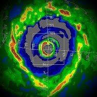
I mean, not to be repetitive here with the radar shots, but even at a distance, this is a very impressive eyewall. Ida is putting on a show. Not to sound happy about it either. Just from a meteorological perspective. Obviously this is a dire situation developing for landfall. We're, what, 9 hrs away?
-
Visually, Ida is essentially text book for an intensifying eyewall at present. You get deformation from isolated intense cells bursting within the eyewall and as such can lead to meso vortices. Also radar is still long range with the beam height above ~25 k ft at this time; so it is possible the reflectivity dbz of the core band will become more of a bright ring as Ida gets closer and the beam reflects from lower in the eyewall. We're essentially limited to the higher/most intense elongated cells at this height.
-
Ida currently has an eyewall suggestive of meso vortices developing. Also this is still at ~25k ft beam height so these are intense cells rotating around the eye at present.
-
Strong and steady rate intensification all evening and some time just before midnight CDT that must have ramped up into a rapid deepening rate of intensification.
-
Beam height is ~30k ft at this distance from KLIX tower. That's already an impressive looking closed eyewall with notable strong cells imbedded within the eye band.


