All Activity
- Past hour
-
Congrats on today Paul
- Today
-
Shouldn’t the thread headline read “5-6-24” instead of “4-6-24”?
- 1 reply
-
- 1
-

-
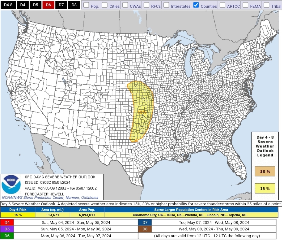
SPC has highlighted a swath of the plains from TX to NE for D6. May is in full swing! Day 4-8 Convective Outlook NWS Storm Prediction Center Norman OK 0403 AM CDT Wed May 01 2024 Valid 041200Z - 091200Z ...DISCUSSION... For Saturday/D4 to Sunday/D5, scattered to perhaps numerous thunderstorms are possible over a large section of the CONUS from the southern Plains into the Southeast. Mid 60s F to lower 70s F dewpoints will be common across the entire area, aided by southerly surface winds around an East Coast high. Aloft, generally weak flow will exist over the same areas, well east of a developing western upper trough. As such, the weak shear will likely minimize overall severe potential through Sunday/D5. For Monday/D6, models have shown increased run-to-run consistency in depicting a deep upper trough developing over the Great Basin and emerging into the Plains. Rich low-level moisture will be in place ahead of this system, which is forecast to enter the central Plains with a negative tilt and strong shear. While minor trough-geometry differences exist amongst the models, the combination of strengthening shear, a potentially deep surface low and ample moisture and instability necessitate introducing severe probabilities for parts of the Plains on Monday. All facets of severe appear possible with such a system, including supercells, squall lines, tornadoes, damaging winds and large hail. ..Jewell.. 05/01/2024
-
Had a super isolated cell roll through Biltmore yesterday afternoon. Literally was hailing on one side and sun out on the other.
-
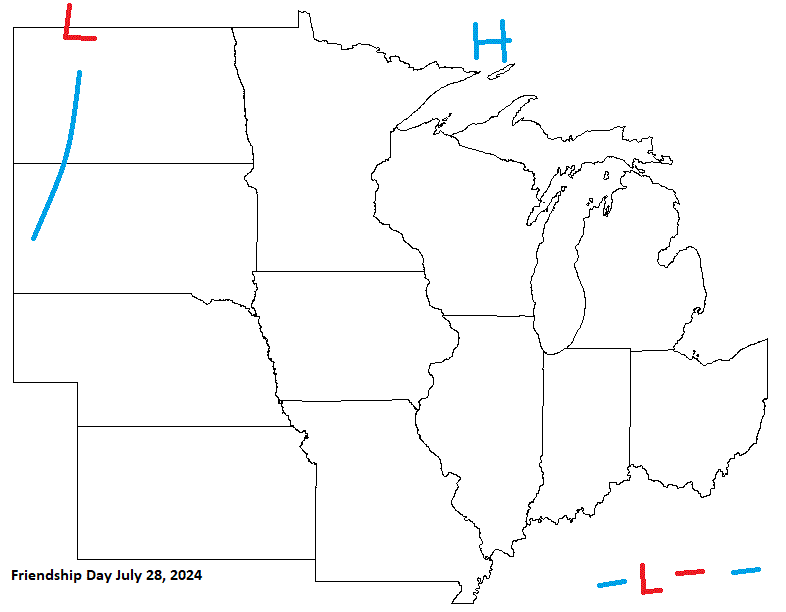
Friendship Day looking pretty decent with most of the sub under the influence of HP. Looks like a boundary may affect the southern most part of the sub. W areas could get a little on the hot side with a boundary in the Plains.
-
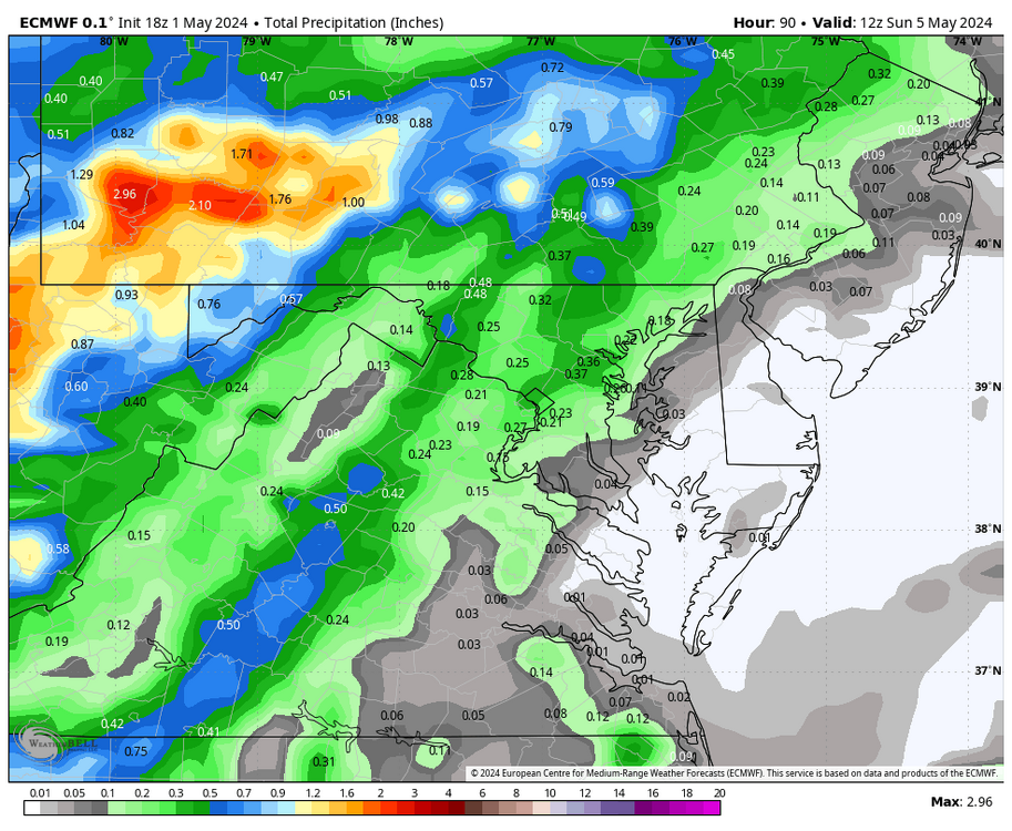
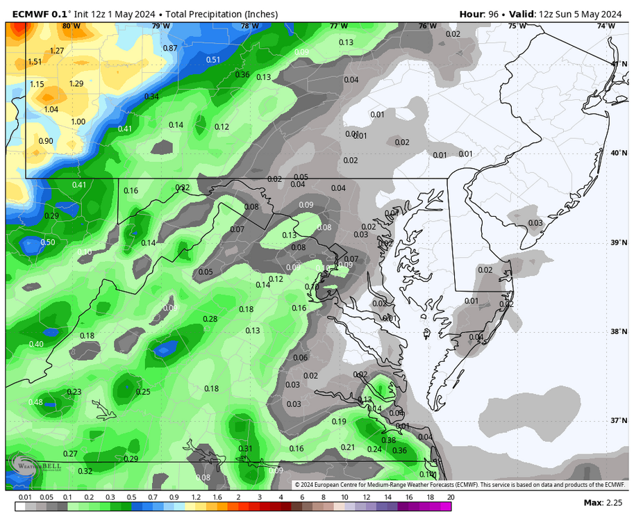
WB 18Z EURO is wetter for Saturday night compared to 12Z.
-

2024-2025 La Nina
Stormchaserchuck1 replied to George001's topic in Weather Forecasting and Discussion
Really nice -PDO pattern in the N. Pacific for the next 15 days (as per 18z GEFS). Fitting the La Nina evolution pretty well. -

May 2024 Discussion - Welcome to Severe Season!!!!
dendrite replied to weatherwiz's topic in New England
55/41 today. Finished with 1.32” of rain. -
Played a few halfcourt games after work and I’ll admit…it was toasty. I think part of it is just getting used to it. I needed this week..but the cooler weather might feel good this weekend lol
- Yesterday
-
July 4th is on a Thursday this year. Looks pretty nice to me. Could get real warm in the W sub on the backside of HP moving through, ahead of next system lurking to the W.

-
Modern is fantastic. Zuppardi's sausage pie in West Haven is outrageous as well.
-
Maybe a larger window of fantastic weather this spring. Usually get this from Memorial Day thru first few weeks of June before heat sets in.
-
Nevermind. I think I found the source:
-

Central Pa. Spring 2024
mahantango#1 replied to mahantango#1's topic in Upstate New York/Pennsylvania
84 for the high today. -
Hot and dry.
-
Seriously smoky conditions on the Upper East Side and Roosevelt Island. Wildfire-related or something else?
-
Isn't this the May MR/LR thread? December a hella long way off. What a start lol.
-
Tomorrow will bring a taste of June with readings rising into the 80s across the region. Hot spots could approach or reach 90°. Overall, the first week of May should wind up warmer than normal, even as there will be considerable variability in the daily temperatures. Showers and periods of rain could arrive during the weekend. Sunday into Monday could be the wettest period. The ENSO Region 1+2 anomaly was 0.0°C and the Region 3.4 anomaly was +0.8°C for the week centered around April 24. For the past six weeks, the ENSO Region 1+2 anomaly has averaged -0.23°C and the ENSO Region 3.4 anomaly has averaged +0.98°C. The ongoing basinwide El Niño event is fading. Neutral conditions could develop later in the spring. The SOI was +6.53 today. The preliminary Arctic Oscillation (AO) was -1.981 today.
-
18Z GFS is a rowboat run. Waiting to mow until Friday is risk for western areas then at least some rain every day going forward for 7 days.
-
The pollen dust in terrible. Just nasty.
- 43 replies
-
- 1
-

-
- spring
- dry weather
- (and 4 more)
-
Up to 81 today here in CNJ pollen is quite high.
-
Records: Highs: EWR: 88 (2010) NYC: 87 (2001) LGA: 85 (2001) JFK: 81 (2001) Lows: EWR: 36 (1978) NYC: 37 (1903) LGA: 38 (1978) JFK: 38 (2008) Historical: 1854 - The Connecticut River reached a level of nearly twenty-nine feet at Hartford (the highest level of record up until that time). The record height was reached in the midst of a great New England flood which followed sixty-six hours of steady rain. (David Ludlum) 1857: The Washington Evening Star publishes the first US national weather summary using observations from volunteers to the Smithsonian Institution's cooperative network. 1933: An estimated F4 tornado struck Minden, Louisiana, killing 28 people and injuring 400 others. 500 homes were damaged or destroyed with $1.3 million in damage. 1935 - Snow, ice and sleet brought winter back to parts of southeast Minnesota. Minneapolis received three inches of snow to tie their May record which was established in 1892. (1st-2nd) (The Weather Channel) 1954 - The temperature at Polebridge MT dipped to 5 degrees below zero to esablish a state record for the month of May. (The Weather Channel) 1987 - Thunderstorms produced large hail and heavy rain in Texas. Baseball size hail pounded Dublin, and 3.75 inches of rain soaked Brady. (The National Weather Summary) (Storm Data) 1988 - Strong southerly winds ahead of a cold front crossing the Rocky Mountain Region gusted to 90 mph at Lamar CO. High winds created blinding dust storms in eastern Colorado, closing roads around Limon. (The National Weather Summary) (Storm Data) 1989 - Thunderstorms produced heavy rain in the southeastern U.S. Rainfall totals of 1.84 inches at Charlotte NC and 2.86 inches at Atlanta GA were records for the date. Strong thunderstorm winds uprooted trees in Twiggs County GA. (The National Weather Summary) (Storm Data) 1990 - Thunderstorms produced severe weather from northern Alabama to North Carolina. There were sixty-three reports of large hail or damaging winds, with hail four inches in diameter reported near Cartersville GA. Ten cities in the southeastern U.S. reported record high temperatures for the date as readings warmed into the 90s. Jacksonville FL reported a record high of 96 degrees. Late night thunderstorms over central Texas produced up to ten inches of rain in southern Kimble County and northern Edwards County. (The National Weather Summary) (Storm Data) 1999: Record, low temperatures for the date, were broken in the Deep South. Mobile, Alabama dropped to 46 degrees. Miami fell to 58; Miami Beach bottomed out at 61, and Vero Beach dropped to 47 degrees, all new records. Other stations in Florida also set record cold maximums for the date, including 61 at Jacksonville and Daytona Beach with 66 degrees. 2003: A record-setting 516 tornadoes occurred during May 2003. In particular, during the period May 4-10, 2003, an unprecedented number of tornadoes, 393 total, affected the central and the southern United States. The tornadoes resulted in 39 deaths across four states. Six of these tornadoes were classified as violent (F4) on the Fujita Tornado Intensity Scale.
-
Sounds good! I gave up being in "pool shape" about 10 years ago...about the time that we started leasing out our share for the neighborhood pool, thank God.
-
Really amazing that the 2nd half of April recorded less than .3” of rain and we still ended up among the wettest April’s. Was a really nasty first half, nice second half. Wonder if we could see our 90s May drought end this year.
-
Just got notice that our neighborhood pool is opening on May 11th! I’m not in pool shape yet.