WxSynopsisDavid
-
Posts
563 -
Joined
-
Last visited
2 Followers

About WxSynopsisDavid

- Birthday 11/12/1988
Recent Profile Visitors


-

Major Hurricane Melissa - 892mb - 185mph Jamaica landfall
WxSynopsisDavid replied to GaWx's topic in Tropical Headquarters
That 902mb measurement also had 22kt winds. That would make it 899mb. Really does suck that we don’t have a recon flight making another pass.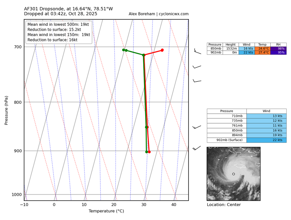
-
Major Hurricane Melissa - 892mb - 185mph Jamaica landfall
WxSynopsisDavid replied to GaWx's topic in Tropical Headquarters
There are a ton of peer-reviewed articles and the NOAA NHC have held seminars discussing this. -
Major Hurricane Melissa - 892mb - 185mph Jamaica landfall
WxSynopsisDavid replied to GaWx's topic in Tropical Headquarters
An ERC is not always a guarantee. If the environment is pristine, the cyclone is healthy, and the cyclone roots in at the surface it takes full advantage of its environment. These scenarios are rare, and a lot of us in this forum never seen it happen until Melissa. When this happens, you don’t get traditional ERC’s. They are MERC’s and they don’t weaken the cyclone: they typically lead to rapid or explosive intensification. -
Major Hurricane Melissa - 892mb - 185mph Jamaica landfall
WxSynopsisDavid replied to GaWx's topic in Tropical Headquarters
As far as today is concerned, there’s been no ERC or MERC. Yesterday, Melissa underwent an MERC. But I don’t know where those Twitter forecasters come up with the conclusion that it happened again today. -
Major Hurricane Melissa - 892mb - 185mph Jamaica landfall
WxSynopsisDavid replied to GaWx's topic in Tropical Headquarters
It is, “merged eyewall replacement cycle” is what Melissa did yesterday. An MERC does not weaken a hurricane, it instead leads to rapid or explosive intensification. MERC are usually seen with these small, compact high-end canes. -
Major Hurricane Melissa - 892mb - 185mph Jamaica landfall
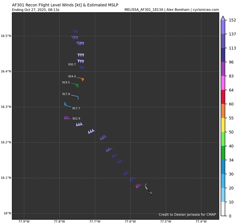
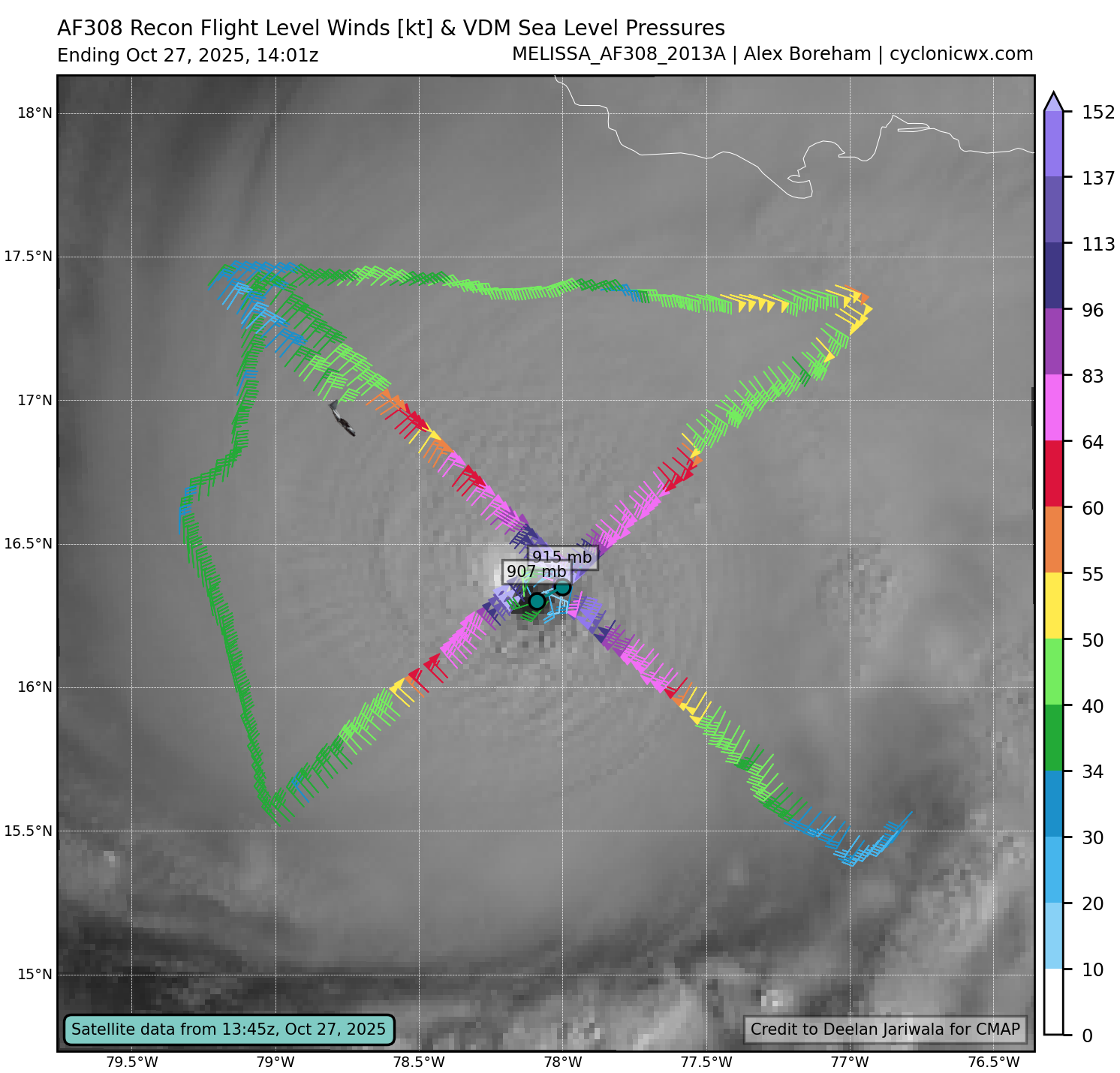
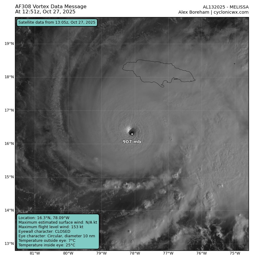
WxSynopsisDavid replied to GaWx's topic in Tropical Headquarters
906mb in W/SW quadrant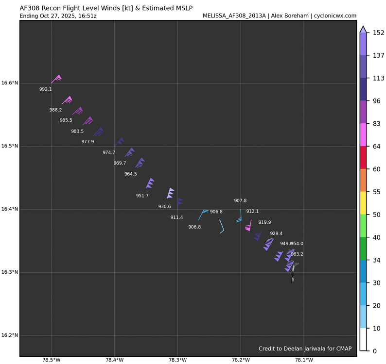
-
Major Hurricane Melissa - 892mb - 185mph Jamaica landfall
WxSynopsisDavid replied to GaWx's topic in Tropical Headquarters
If an ERC happens, windfield expands. It’s almost fair to say the “best case scenario” from the wind and surge aspect is for Melissa to landfall with no ERC before landfall. If an ERC occurs, that tight window of Cat4/Cat5 5 winds will double or triple in size. Also, the storm surge would compound and grow higher. -
Major Hurricane Melissa - 892mb - 185mph Jamaica landfall
WxSynopsisDavid replied to GaWx's topic in Tropical Headquarters
Also, Melissa is not a large hurricane but rather a small and compact hurricane. The eye is also small too, and the compact system and pinhole eye means the area of maximized winds is small. It’s possible recon missed the max in the NE quad. -
Major Hurricane Melissa - 892mb - 185mph Jamaica landfall
WxSynopsisDavid replied to GaWx's topic in Tropical Headquarters
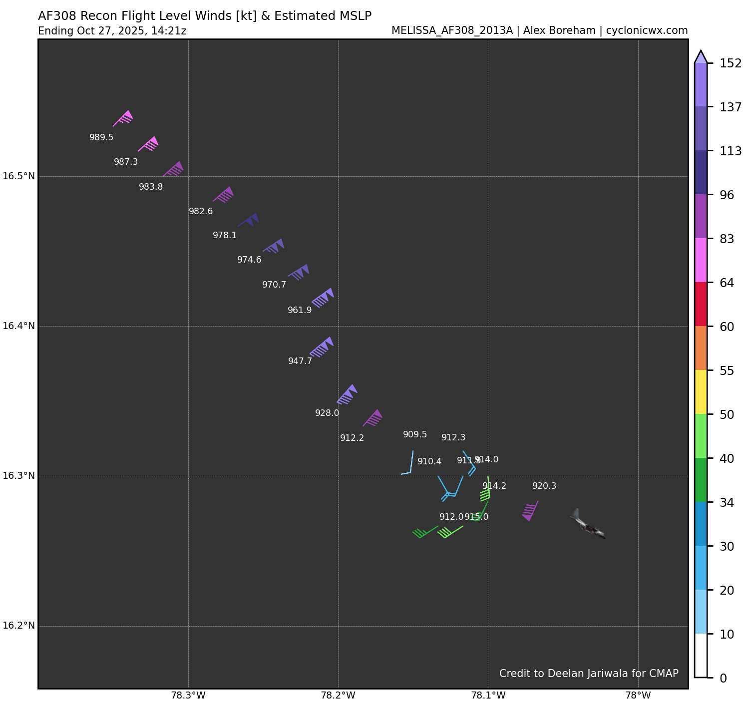
I think at this juncture, given the pristine environment until landfall and how healthy Melissa is, it’s hard to fathom any additional intensification. Melissa is making a serious run at sub-900 pressure in a tight window before landfall. -
Major Hurricane Melissa - 892mb - 185mph Jamaica landfall
WxSynopsisDavid replied to GaWx's topic in Tropical Headquarters

-
Major Hurricane Melissa - 892mb - 185mph Jamaica landfall
WxSynopsisDavid replied to GaWx's topic in Tropical Headquarters
Adjusted to 907mb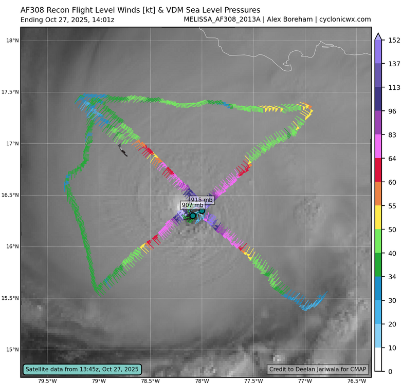
-
Major Hurricane Melissa - 892mb - 185mph Jamaica landfall
WxSynopsisDavid replied to GaWx's topic in Tropical Headquarters
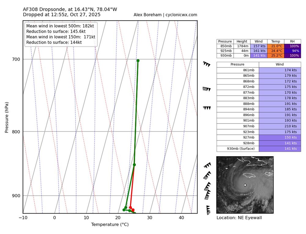
WOW!!! Between passes, gusts go from 194kts to 210kts. In the more recent dropsonde, notice how the temperature and dewpoint lines zigzag at the bottom. This means the dropsonde rotated and touched all 4 quads of the eye. Melissa is in extremely rare air, officially the 3rd highest gusts ever recorded by recon hunters.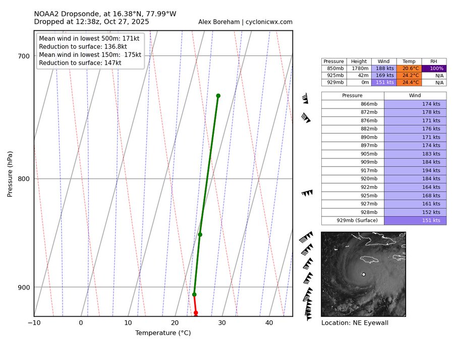
-
Major Hurricane Melissa - 892mb - 185mph Jamaica landfall
WxSynopsisDavid replied to GaWx's topic in Tropical Headquarters
Recon measured 158kts in the north eyewall at the surface. This equates to 180-185mph range for surface winds.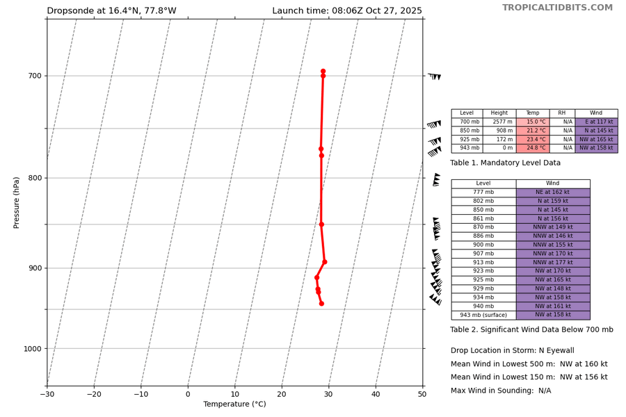
-
Major Hurricane Melissa - 892mb - 185mph Jamaica landfall
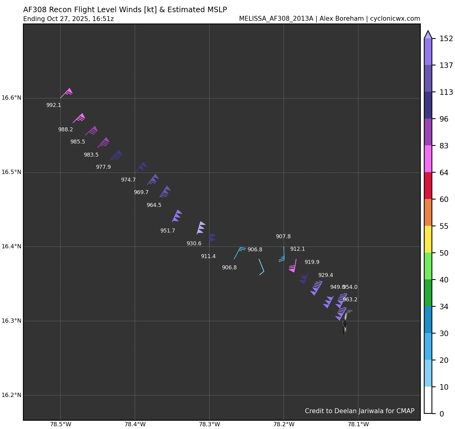
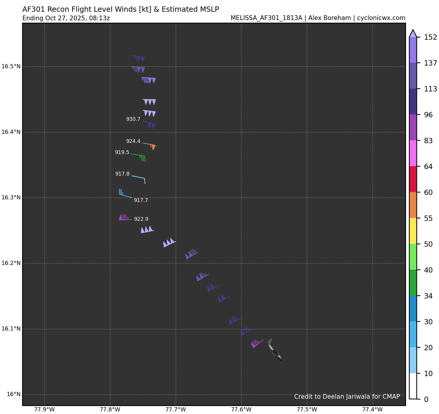
WxSynopsisDavid replied to GaWx's topic in Tropical Headquarters
917mb in N/NE quad. Along with the 140kts they measured earlier in the NE quad, Melissa will now be upgraded to a Category 5. Either we get a special advisory or they wait for 5am.