All Activity
- Past hour
-

Richmond Metro/Hampton Roads Area Discussion
wasnow215 replied to RIC Airport's topic in Mid Atlantic
Still time for next week -
It gives me faith that I can produce a multitude of ways in the future. It’s been a tremendous year at SLK with only 3 or four low end warning level events.
-

Pittsburgh/Western PA WINTER ‘25/‘26
Rd9108 replied to Burghblizz's topic in Upstate New York/Pennsylvania
Shocker or is it right where we want it this far out -

Outta gas and Outta Time: Early March Winter Storm finale
NorthArlington101 replied to Ji's topic in Mid Atlantic
Looks fine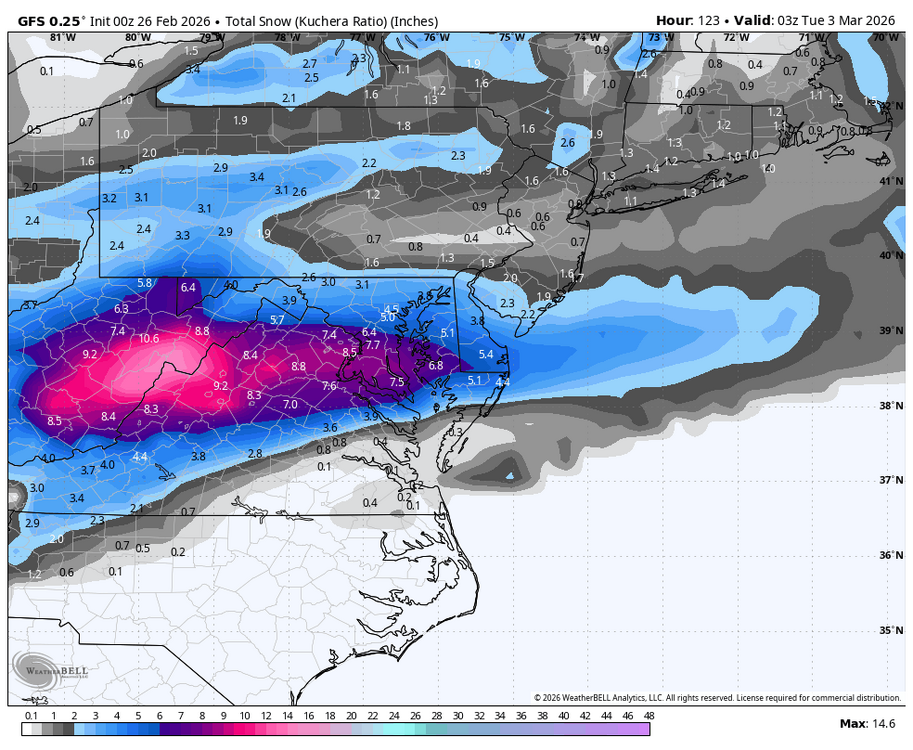
-
Kind of dumping graupel right now. Weird. 26F
-
0z GFS wants to give favored CAD areas in NC and upstate a krispy kreme glaze on the 3rd
-
Those general upslope areas seem to have done ok which makes sense given the number of clippers and northwest flow disturbances we’ve had…but once you are further east out of the upslope spots, its def been pretty dry.
-

Pittsburgh/Western PA WINTER ‘25/‘26
colonel717 replied to Burghblizz's topic in Upstate New York/Pennsylvania
GFS trending towards other guidance. -
Between this story and that YouTube above, this guy is total dink. There's a way to commit to the bit and make it funny. He's just sort of an asshole. And (likely) wrong in his assertions. A truly terrible combination.
-

E PA/NJ/DE Winter 2025-26 Obs/Discussion
MJO812 replied to LVblizzard's topic in Philadelphia Region
Gfs further south I still think Sunday wave ruins the Mondays storm. Better runs had that wave non existent. That wave drags the trough further south for monday. -
I dissent I think the tempo fits just fine! In fact, a case could be made that this tempo makes the eventual POP! more effective because it's more of a walking tempo (the GIF about 97 bpm...so Andante) That is just slow enough to kinda lull ya before surprise--just like the famous movement from Haydn's "Surprise" symphony (which incidentally also goes well with this, haha) That tempo is an Andante as well which makes the surprise even better. Do it too fast and the POP loses it's distinctiveness. So...walk don't run before the POP! That's my musical case for why that tempo works and I dares is even better!
-
I still think Sunday wave ruins the Mondays storm. Better runs had that wave non existent. That wave drags the trough further south for monday.
-

Outta gas and Outta Time: Early March Winter Storm finale
stormtracker replied to Ji's topic in Mid Atlantic
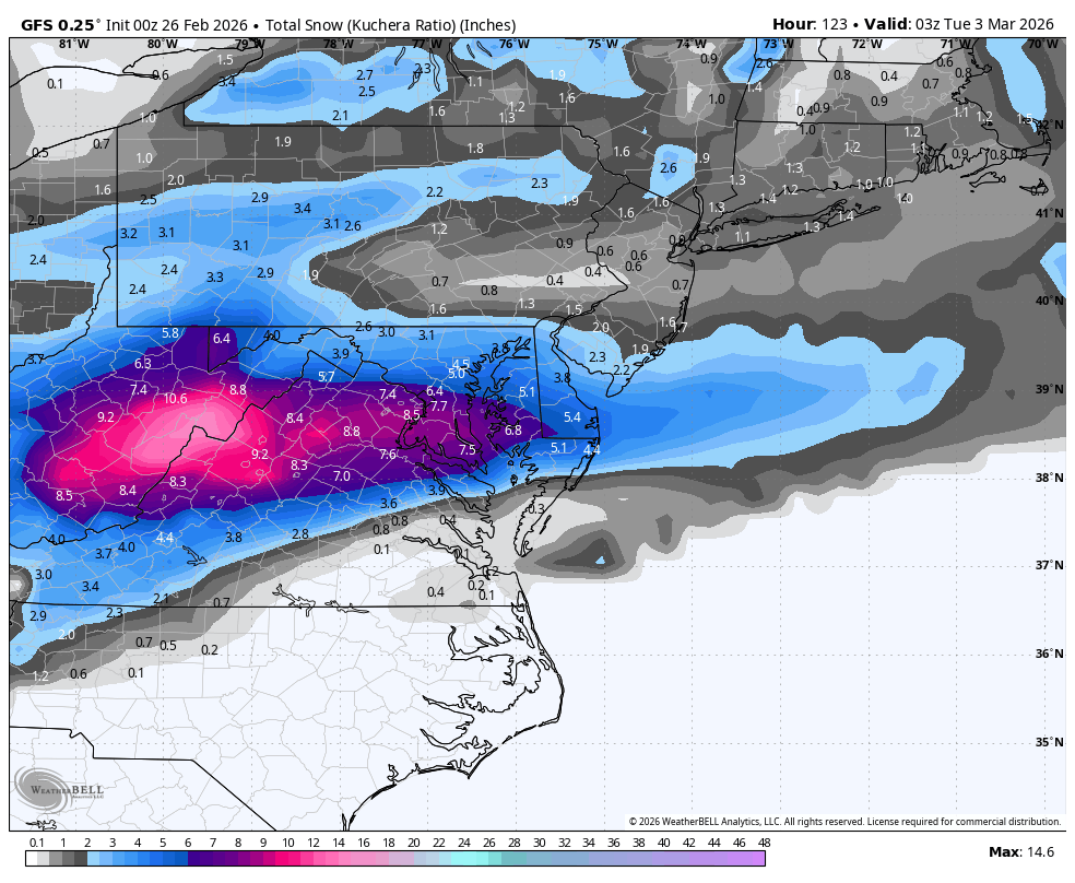
Well, Pivotal says 5, so what do I know...Kuchera. SV maps are so bad. I dunno. It was def drier than 18z -
Outta gas and Outta Time: Early March Winter Storm finale
stormtracker replied to Ji's topic in Mid Atlantic
ATP, this is the GFS going toward the EURO. Looks like we're tracking a 1 to 2 inch snow -
Outta gas and Outta Time: Early March Winter Storm finale
stormtracker replied to Ji's topic in Mid Atlantic
Snow over the area at 114, but....a good bit drier for most -
I (so badly) want this to be a troll job by him, but based on the evidence (read: his posts here), my conclusion is that he is, most certainly, NOT.
-
Outta gas and Outta Time: Early March Winter Storm finale
stormtracker replied to Ji's topic in Mid Atlantic
Yeah, GFS is drier out west...prob gonna be drier overall from what I can see -
lol

-
Very very lucky out at WXW2…
-
April fools lol
-
My gut tells me a cold shot on Monday, but no snow. If there is a precip event, it will be Tuesday night into Wednesday, and will be primarily rain. After that will be a huge warm up.
-
Imo, if we get a +pdo and -amo, we should see colder winters more often. We are due for that soon I believe.
-
Fold
-

"Don’t do it" 2026 Blizzard obs, updates and pictures.
dendrite replied to Ginx snewx's topic in New England
PVD had a 37” depth gain and reported “only” 37.9” new -

Is we back? February discussion thread
TauntonBlizzard2013 replied to mahk_webstah's topic in New England
It’s been dry here overall, so I guess we’ll take the rain lol


.thumb.png.4150b06c63a21f61052e47a612bf1818.png)