All Activity
- Past hour
-
-
I know it’s way too early for accumulation projections but The Weather Channel has me down for 5-8” and AccuWeather 3-6”. One can only dream. .
-

Nov 28-30th Post Turkey Day Winter Storm
OrdIowPitMsp replied to Chicago Storm's topic in Lakes/Ohio Valley
Still churning out pixie dust at a decent rate. It’s been a 14-1 snow/liquid ratio at the airport. -
-

First Winter Storm to kickoff 2025-26 Winter season
weatherwiz replied to Baroclinic Zone's topic in New England
Can't wait to see how amped the NAM turns out to be based on the look so far. -
Nov 28-30th Post Turkey Day Winter Storm
hlcater replied to Chicago Storm's topic in Lakes/Ohio Valley
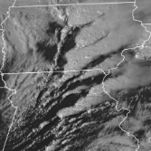
10.2" on the stick. Perhaps another inch yet to go per guidance and radar trends. -
28° here
-

First Winter Storm to kickoff 2025-26 Winter season
Torch Tiger replied to Baroclinic Zone's topic in New England
-
Nov 28-30th Post Turkey Day Winter Storm
ChiTownSnow replied to Chicago Storm's topic in Lakes/Ohio Valley
Nice weenie band overhead.. Good storm . Fun to track.. let's do it again -
brewman22001 started following December 2025 Short/Medium Range Forecast Thread
-
December 2025 Short/Medium Range Forecast Thread
brewman22001 replied to John1122's topic in Tennessee Valley
Getting sleet here in the Rutledge Pike area as well . -

First Winter Storm to kickoff 2025-26 Winter season
weatherwiz replied to Baroclinic Zone's topic in New England
Isn't Google DeepMind the one which has had extremely encouraging results, however, also described as "the model is able to produce great results, however, the model has no clue how it derived the results". There was some article or paper on this a year or two ago. -
Temp just dropped to 30.
-

Nov 28-30th Post Turkey Day Winter Storm
cyclone77 replied to Chicago Storm's topic in Lakes/Ohio Valley
Sure was nice to use the snowblower and not freeze to death. Snow is wetter feeling than expected. Probably from the wind granulating it. Guessing ratios were pretty close to 10:1. Haven't measured since 5 but may have added a half inch. Snow's been very light the past few hours. DVN was 9.5" as of 6pm, MLI had 8.8". -
Stop whining about the NS lol. In winter a busy NS is the norm more times than not, unless we are torching, then who cares. A quiet NS in a 'good winter pattern' usually only happens when we have a legit persistent NA blocking pattern like 2009-10, in something like the ideal Modoki Nino with a legit southern jet. Doesnt happen that often.
-

First Winter Storm to kickoff 2025-26 Winter season
CoastalWx replied to Baroclinic Zone's topic in New England
Wish they had that model running for something other than tropicals. -

Nov 28-30th Post Turkey Day Winter Storm
Chambana replied to Chicago Storm's topic in Lakes/Ohio Valley
The best part about this storm? It’s only November 29th. What a bang to start the winter season. Thundersnow was reported in Mahomet roughly 15 miles from Champaign. Such a good storm. -

Nov 28-30th Post Turkey Day Winter Storm
michsnowfreak replied to Chicago Storm's topic in Lakes/Ohio Valley
DTW has been SN+ for 2 hours now. Visibility low and roads slippery. Beautiful out! -

First Winter Storm to kickoff 2025-26 Winter season
weatherwiz replied to Baroclinic Zone's topic in New England
doing both -
Nov 28-30th Post Turkey Day Winter Storm
A-L-E-K replied to Chicago Storm's topic in Lakes/Ohio Valley
Another nice period here, nothing too extreme rate wise at any point but done well to avoid any prolonged screw holes -

First Winter Storm to kickoff 2025-26 Winter season
kdxken replied to Baroclinic Zone's topic in New England
Eff the bufkit. Watch the game. Saturday, Saturday, Saturday night's all right. -
If you compare the 500mb maps they aren’t all that different. The block west of alaska on aifs ens is further west on eps, but eps shows more western US ridging. Both show a TPV in canada with a eastern trough and a -NAO. Biggest thing is how the Alaska domain is resolved, as that will have big effects downstream.
-
E PA/NJ/DE Autumn 2025 Obs/Discussion
simbasad2 replied to PhiEaglesfan712's topic in Philadelphia Region
All the other regional sub forums have done it, I think a board for the December 2nd storm should be created sometime today or tomorrow -
I see just about everyone has tossed in the towel. So for now it's the best global modeling in the world (EC-EPS ECAI) vs all the other warmer model runs. Results ahead... front end could be a little bit of accumulative fun for us Tuesday morning. Will check back tomorrow to see if my over reliance on these colder cycles have any validity going forward.

