All Activity
- Past hour
-
I haven’t seen any +PNA Feb predictions on twitter, even from BAM. Seeing a ton of “look, it’s not a torch posts” which is weird because I also can’t find any reputable post that predicted a torch.
-
We got soft over the last 4 years.
-
There will be another relaxation. It makes sense. It would be harder for one not for one to occur... patterns only last so long in our area.
-
So weird. It was a decent snowfall, but not the meatiest stuff. And there has been over a week to clear it. I wonder why it has been so problmatic
-
Hires models conceding to King Hires-RGEM and showing very little moisture East of 77
-
Sure. However that wasn't the context I was going for. 384 hour weenie maps were being posted with doom and gloom comments! While any weather scenario is always on the table, basing an opinion on a forecast outcome on that particular data set was quite silly. That's my point. If we are looking at a 5 day forecast for it to be bone dry, then it's definitely a very possible forecast and weather outcome. Cold air is around. There will be chances that aren't even showing up in the models. They may not work out but there will be trackable systems over the next few weeks.
-
Ten days after and I drove past an open (no cover) golf course today, and it’s still 100% covered. That’s remarkable for the last 25 years, including some of the big blizzards.
-

Winter 2025-26 Medium/Long Range Discussion
A-L-E-K replied to michsnowfreak's topic in Lakes/Ohio Valley
east coast pattern redux?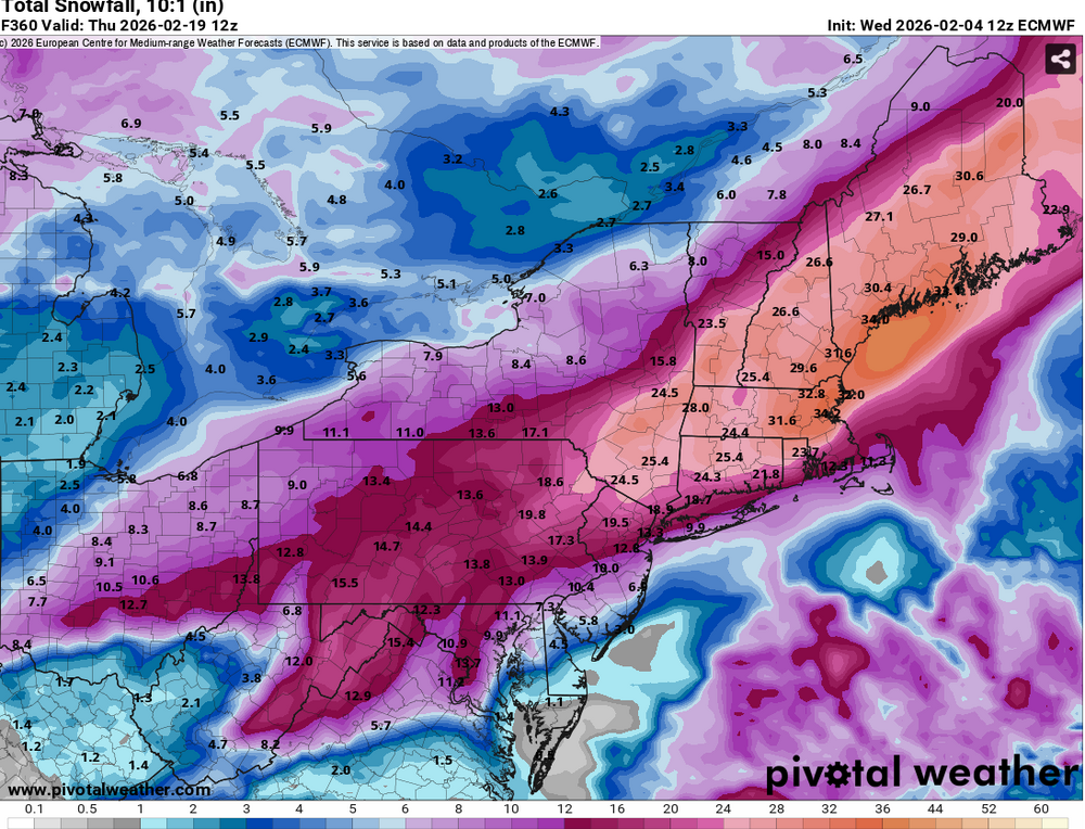
-
A single run of the gfs showed an epic storm but was not supported by anything else.
-

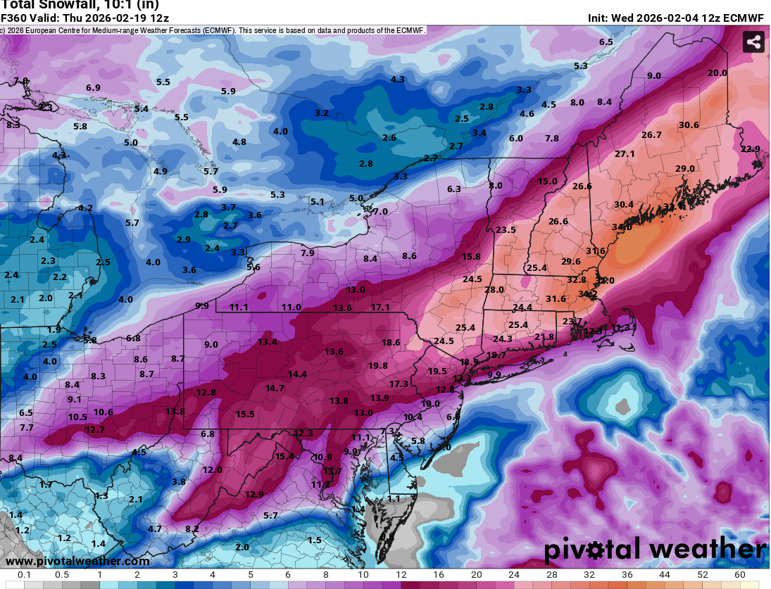
February 2026 Medium/ Long Range Discussion: Buckle Up!
nw baltimore wx replied to Weather Will's topic in Mid Atlantic
-
Just based on what I see, I think after the 15th we turn mild. Then late month winter tries to return.
-
PNA losing relevancy after mid Feb due to changing wavelengths. -PNA becomes more favorable for snows here than a +PNA by latter Feb.
-
Also have to remember peak climo too…if it pans out, with a good track, it’ll easily be snow just away from the coast with a storm of that magnitude. And SST are frigid so that will help(the shore/and everybody) as well.
-

Pittsburgh/Western PA WINTER ‘25/‘26
RitualOfTheTrout replied to Burghblizz's topic in Upstate New York/Pennsylvania
If models were a buffet... I'd take a side of GFS for this weekend, scoop of the UKMET for midweek, and for my main course I'll take the Euro for next weekend. Once the desert cart comes around for late feb / early march, I'll see what I want off of that. -

Friday February 6 FROPA / WINDEX small event
Snowcrazed71 replied to HoarfrostHubb's topic in New England
Are we getting that inverted trough into Connecticut by us? -
We were planning to head out after kid is out of school Fri. May have to pass unless loudoun cancels.
-
A decent storm signal, but as of now still a 240 hr (well, slightly under) pipe dream.
-
INCOMING.... not sure if it's rain, sleet or snow. Probably rain at least to start but it may be snow further north into Hampton roads.
-

February 2026 Medium/ Long Range Discussion: Buckle Up!
Eskimo Joe replied to Weather Will's topic in Mid Atlantic
-
Much like the addition of lanes to 440, such capital and maintenance expenditures on our roadways do little to tame the natural behaviors of area wildlife (Nissan Altimas).
-

February 2026 Medium/ Long Range Discussion: Buckle Up!
stormy replied to Weather Will's topic in Mid Atlantic
Is it possible that the pattern is beginning to feel the warming ENSO? -

Pittsburgh/Western PA WINTER ‘25/‘26
colonel717 replied to Burghblizz's topic in Upstate New York/Pennsylvania
Too bad Lake Erie is frozen over, but hopefully the front passing can stir up some nice squalls. -
No way, not there, lol
-
I don’t think there will be some stupid cold antecedent, this will be on the edge for ptype
-

February 2026 Medium/ Long Range Discussion: Buckle Up!
midatlanticweather replied to Weather Will's topic in Mid Atlantic
We can hope. But usually when your idea the southern extent you get screwed... Unless you have a massive block that makes it slide south.. But it is still time to track.. So that is good