All Activity
- Past hour
-
Oh wow that's classic for a KU event in these parts.
-

E PA/NJ/DE Winter 2025-26 Obs/Discussion
Newman replied to LVblizzard's topic in Philadelphia Region
DGZ is -12C to -17C. For many across SE PA, the entire atmospheric column is between this up to like 600 or 500mb. Even down to the surface in many places. If you throw some strong omega into the mix, poor snow growth would be the least of my worries. You're right though, if things were colder than -17C then we'd be looking at less stellar dendrites -
The 0z (and seems like 6z) euro evolution is what I was honking at last night with the 18z run. Long duration events are super rare for a reason, but I’m getting major PD2 type vibes with overrunning and then a coastal. This thing keeps slowing down though so we’re only gaining like 45 minutes on the start time for every hour that passes lol.
-
Looks like the timing of the peak was such that Europe got the best of it last night. Some spectacular pictures. France:
-

Possible Record Breaking Cold + Snow 1/25 - 1/26
Jersey_Snowhole replied to TriPol's topic in New York City Metro
6z euro would’ve been absolutely crazy if it went past 144 -
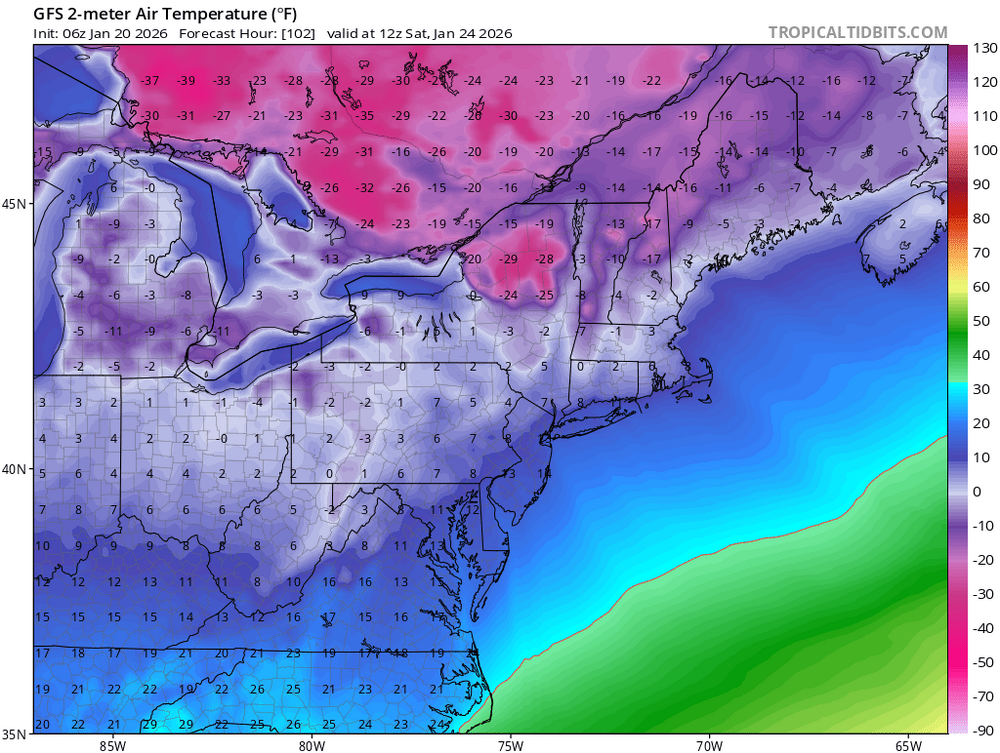
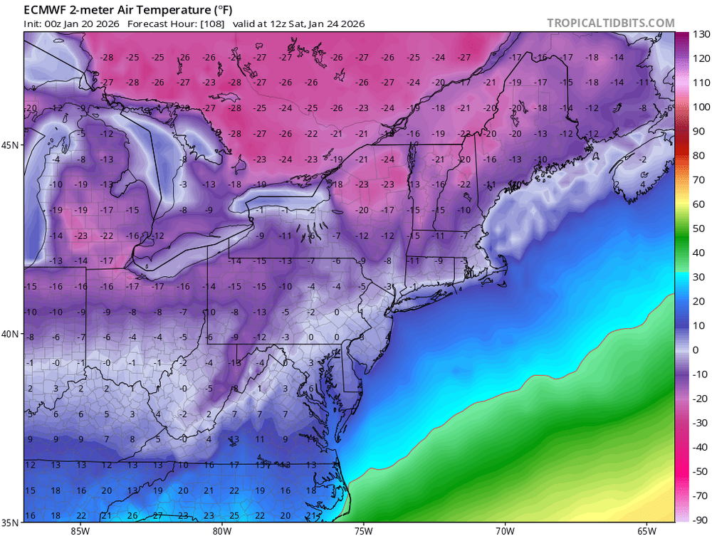
The raw Euro 2m Ts have been running too cold. It forecast around 11° this morning in NYC. The current temperature is 17°. For some reason the raw GFS has been doing better than the Euro. So my guess is that the forecast Euro lows especially around the urban areas from EWR to NYC will be too cold coming up. For some reason the model thinks that NYC should have strong radiational cooling when there is snowcover. We saw this in the past from the OP Euro 2m Ts showing -5° to -10° several years back in. NYC with snow on the ground. But outlying areas with the best radiational cooling will probably be closer to the mark than the urban areas forecast.

-

January 2026 regional war/obs/disco thread
Baroclinic Zone replied to Baroclinic Zone's topic in New England
I was just thinking the same thing. That euro solution was interesting. Too soon to really over analyze much imo but for winter enthusiasts it’s looking promising. -
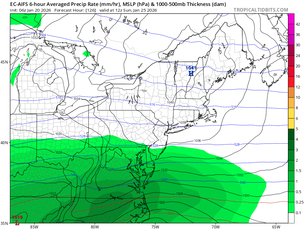
Euro 144hrs 700mb RH map. Southwesterly winds pumping in Gulf moisture all the way back to central Missouri. Yeah...it's gunna' keep snowing for a while after the 144hr panel.
.thumb.png.7c0ed2a6d21f91cd385c8bc30a0313fa.png)
-
The one thing i worry about is if local mets have been torched time after time that they are afraid to hype this up early and completely drop the ball when it comes to getting info out in a timely manner if this storm is as advertised. .
-

E PA/NJ/DE Winter 2025-26 Obs/Discussion
Ralph Wiggum replied to LVblizzard's topic in Philadelphia Region
NAM has the high-pressure 1057 mb as it peaks. Just insane! -
Crazy long duration depicted by the Euroai Starts overnight Saturday into Sunday and doesn't pull out till Early Tuesday.
-
E PA/NJ/DE Winter 2025-26 Obs/Discussion
Ralph Wiggum replied to LVblizzard's topic in Philadelphia Region
Was going to say this. Seems like we are moving away from suppression now as this morphed into a full phase system (possibly) and in 24 hrs we might be hoping for the N trend to stop. -

January 2026 regional war/obs/disco thread
WinterWolf replied to Baroclinic Zone's topic in New England
You’re in the heart of winter now..enjoy. The days get longer, but the cold gets stronger..that will be very true these next few weeks. Cherish/enjoy it. -

January 2026 regional war/obs/disco thread
jbenedet replied to Baroclinic Zone's topic in New England
Positive trade off to eliminate the daily black ice risk. Too much of this in December and January. Cities could do more, but they don’t. -

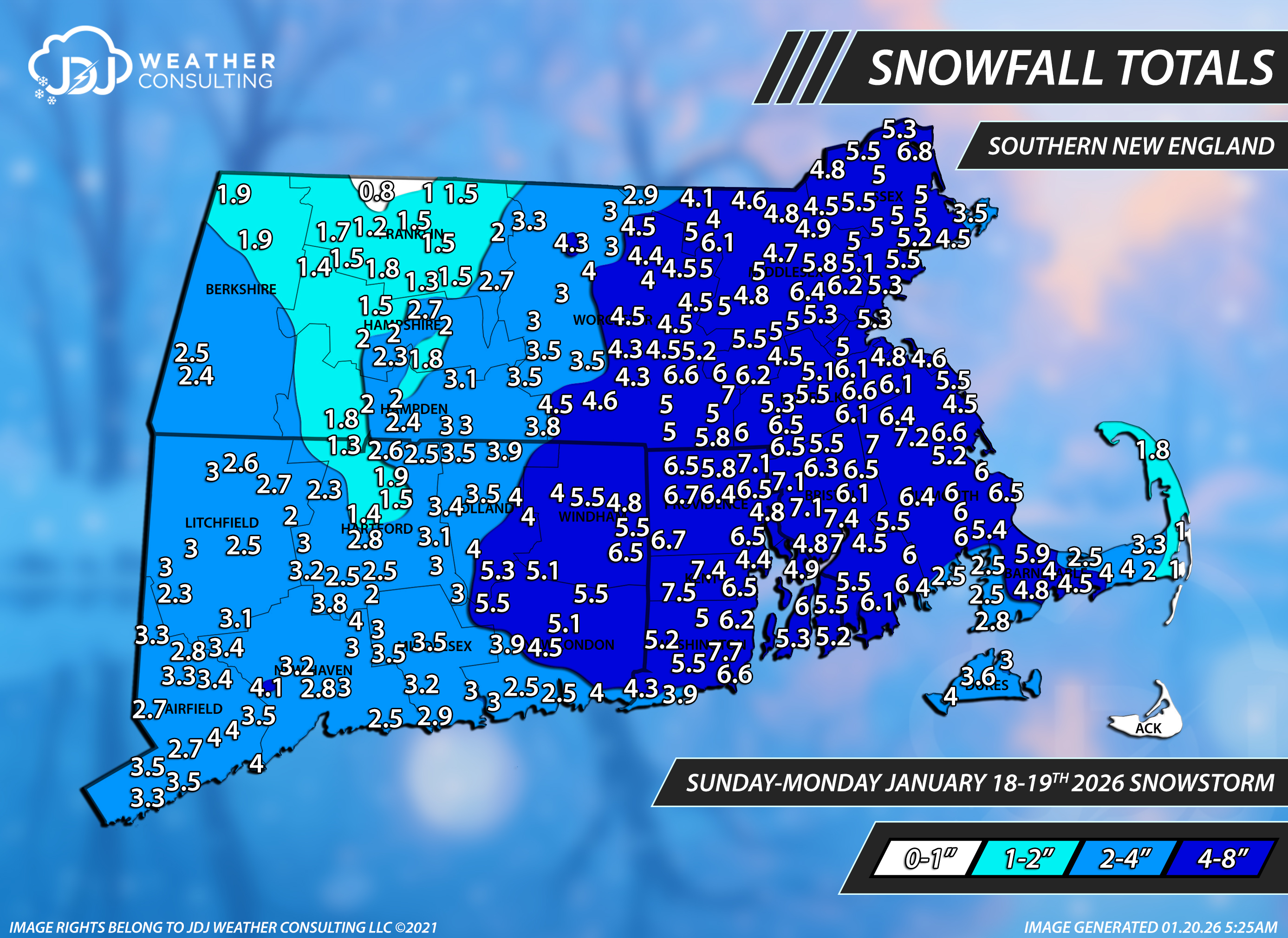
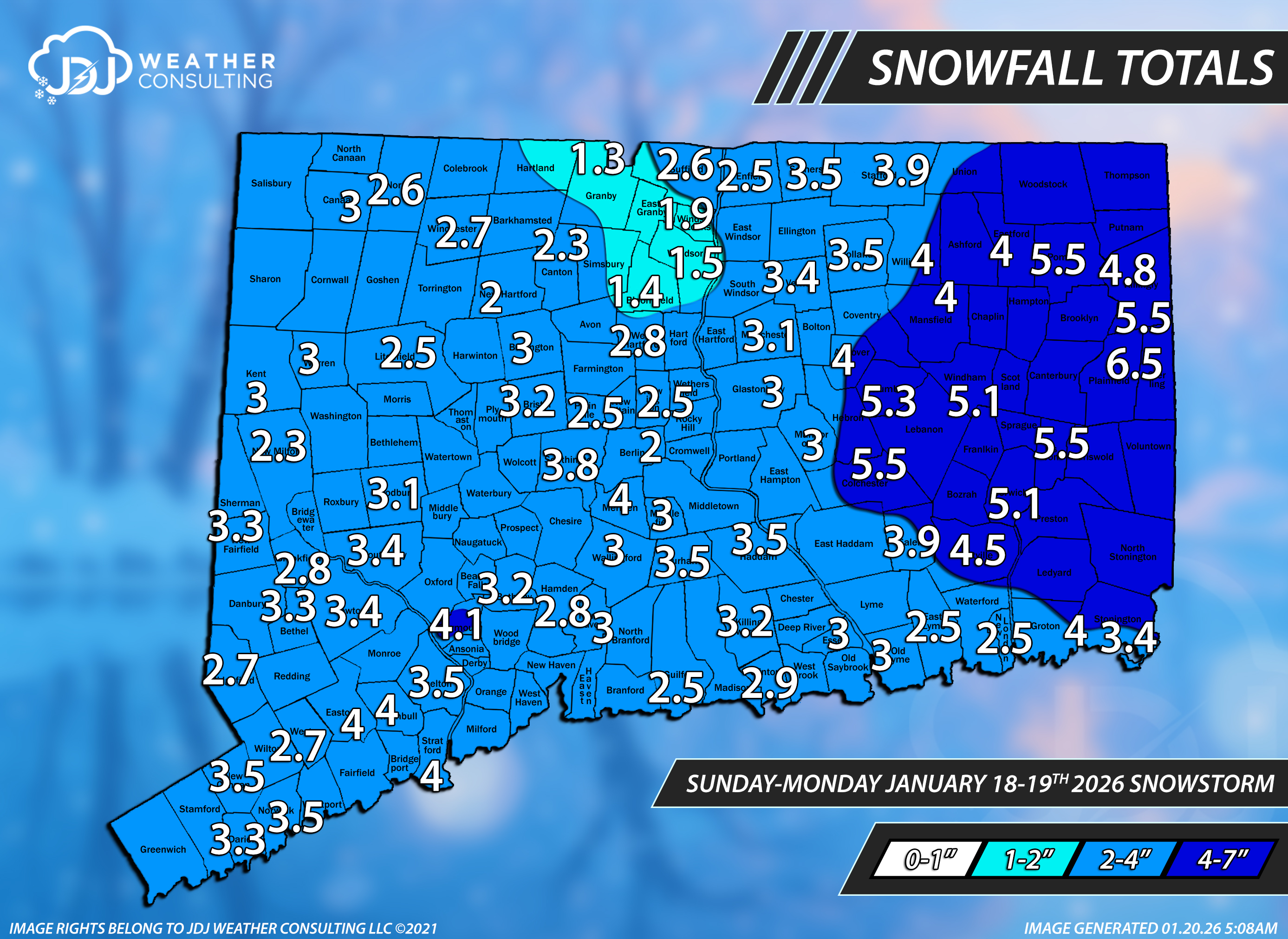
Rise of the Machines: January 18-19 Winter Storm Obs Thread
The 4 Seasons replied to WxWatcher007's topic in New England
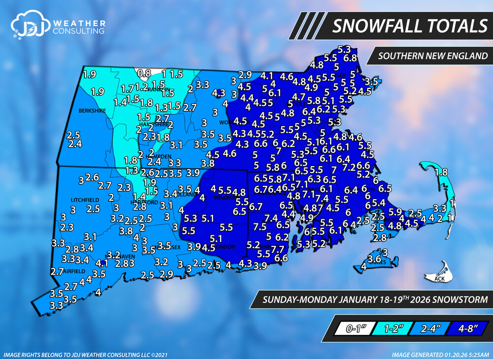
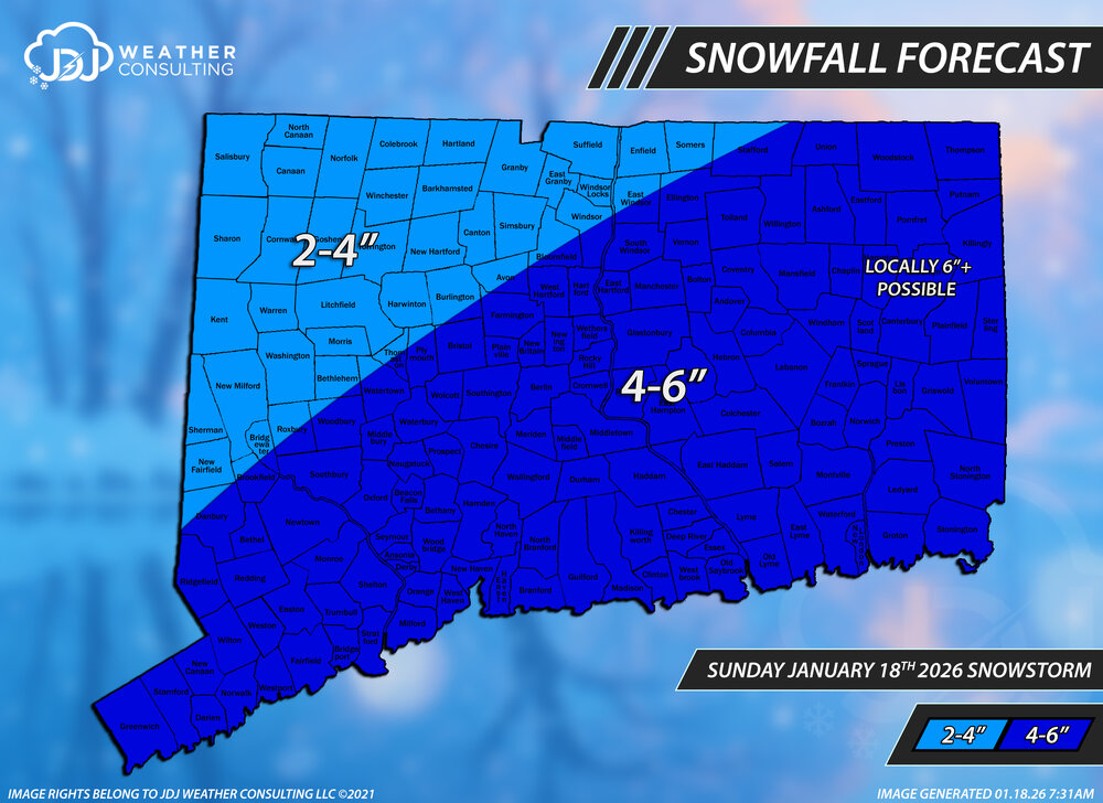
Snowfall totals for the Jan 18-19th system. Thanks for all the reports from everyone here, i tried to include most of them if they fit. All these maps for the 25-26 season are available at the website if and when they eventually get removed from here. https://www.jdjweatherconsulting.com/winter-25-26 The final call we put out was for 2-4/4-6 for most of the state and it turned out it wasn't as bad as i thought. The 4-6" line should have been around the river and east and it would have been fine. General idea was correct and the text info with locally 6+ was good. C- Lower Northeast Southern New England Connecticut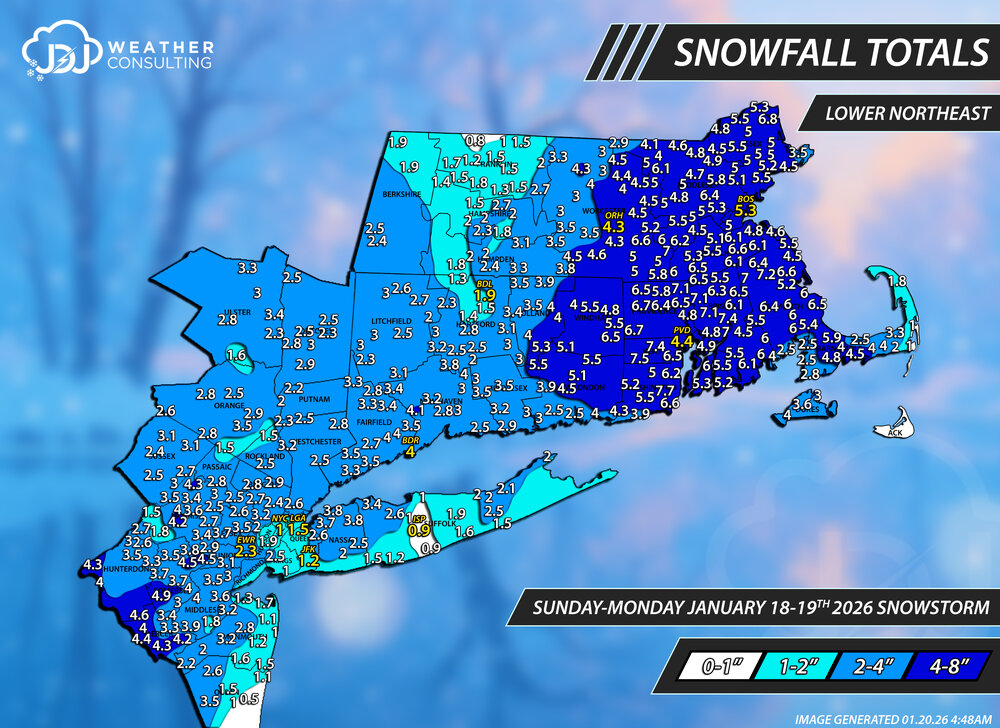

-
LOL I will be able to post my photos by June.
-

E PA/NJ/DE Winter 2025-26 Obs/Discussion
Duca892 replied to LVblizzard's topic in Philadelphia Region
I can’t read much to me it looked like OP GFS 6z was the slightest step back from 0z, but still primarily the same. Would have liked to see that continue north -
E PA/NJ/DE Winter 2025-26 Obs/Discussion
Newman replied to LVblizzard's topic in Philadelphia Region
6z GFS Op and GEFS came north again, AIGFS is a southern outlier for now. With a potential phase that models seem to be heading towards, I think a southern slider solution becomes much less likely -
E PA/NJ/DE Winter 2025-26 Obs/Discussion
Newman replied to LVblizzard's topic in Philadelphia Region
Are you thinking about chasing this one or gonna stick it out in Philly? I guess it depends on where we end up with this in a few days... -

Central PA Winter 25/26 Discussion and Obs
Blizzard of 93 replied to MAG5035's topic in Upstate New York/Pennsylvania
Great trends continue at 6z for this weekend. 6z GEFS bumped north with the good snow by at least 50 miles over 0z.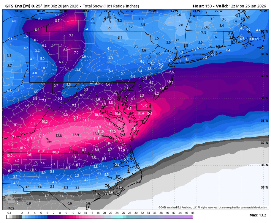
-
To hard to tell right now. It's all going to happen at the 700mb level. Warm nose comes in way up high and produces full melt, then it falls through 5000ft of frozen, hits the surface at 21 degrees as sleet because after full melt we have full freeze again. I am banking on sleet over freezing rain. Sounding screams full melt then full freeze again. General rule of thumb from what I learned was that you need around 1500' of above freezing temps for the parcel to fall through to produce full melt and the same is true with refreezing of precipitation.
-
Just woke up to those monster 6z runs.....insane! Not sure if anyone has mentioned GEFS yet, but looks like most of the forum has a mean of 10-12" 5 days out!
-
Spot the ball
-

January 2026 regional war/obs/disco thread
Damage In Tolland replied to Baroclinic Zone's topic in New England
Thursday will be first higher sun angle day with temps in 30’s where you’ll start to notice it on south facing slopes with snow melt. Hate that -
The 06z UK has the Baja energy hanging back a little more than 00z. Which is great! It's one of the northern models currently. Only goes out to hr 66 at 06z


.png.3e94864b39d208f4c6a0111ac225a729.png)