All Activity
- Past hour
-

Overnight Wednesday, November 5, 2025 Wind Event
metagraphica replied to weatherwiz's topic in New England
Perfect, nobody wants damage and/or power outages. -
Yes. It's so difficult to find any info regarding events in this area. I dig through this forum a lot to find storms. Too bad it wasn't around before the 2010s.
- Today
-
BWI: 19.2" DCA: 18.3" IAD: 19.8" RIC: 11.2" SBY (Tiebreaker): 8.2"
-
Rib injuries are so dumb that I want November snow. I'm all in on a '25/26 HECS/MECS/SECS trifecta.
-
Finished with .72”
-
First Sunken Meadow, now North Shore Tower. Deer must like the golf courses because they've seen the aim of the people at those places and know they're perfectly safe.
-
Monday's rain went poof.
-
Lots of backing down by 00z model runs...
-
This is a longwave pattern that could produce some decent snow in the mountains and possibly first flakes for places east of there around Veteran's day.
-
-
Regardless of if Sunday Night's event is a snower or cuts west, the cold and moist cyclonic flow looks consistant and filled with potential subtle shortwave features next week. Still a ways to go until confidence increases substantially, but if the pieces align correctly a real solid upslope signature may emerge under the incoming trough.
-
Maybe some flurries make it over the mountain Monday night
-
I think it was November 11-12 ,2021 we got 4 to 7 inches from anafrontal. Let's not forget last year the first measurable snowfall was November 22. I measured 2.8" . Some Locations higher up had several inches more. November had decreased in Snowfall Averages over the last 50 Year's. Maybe that is changing. Who knows.
-

November 2025 general discussions and probable topic derailings ...
alex replied to Typhoon Tip's topic in New England
Wintry appeal
-

Overnight Wednesday, November 5, 2025 Wind Event
Typhoon Tip replied to weatherwiz's topic in New England
NAM still not interested in much over 40 -
If you notice, KMRX always broadbrushes the elevation regardless of Latitude. Also, Models are showing flakes reaching Valley Floors in SWVA, and NETN. but yet no mention of the possibility . I know it's 5-6 days out but still.
-

Overnight Wednesday, November 5, 2025 Wind Event
Torch Tiger replied to weatherwiz's topic in New England
are you talking wind or snow? I recall that storm well and snowfall was very well-forecasted, as were winds...besides the really high-end reports. NWS at least, didn't hit on the far SE/ CC wind impacts but that was extraordinary. Great storm -
BWI: 16.8" DCA : 13.9" IAD : 15.9" RIC :7.1" SBY:5.9"
-
18z is when the model was ran. This time of year, 0z is the 7pm, 06z is 1am, 12z is 7am, and 18z is 1pm, all those are EST, subtract an hour for CST. Usually around 4 hours after that initialization time, the results show up on websites. The Euro is more like 5 hours later. Carvers' map up there is the output for 21z next Monday. 4pm/3pm November 10th.
-

Overnight Wednesday, November 5, 2025 Wind Event
ineedsnow replied to weatherwiz's topic in New England
every time a thread is started it turns into meh -

November 2025 general discussions and probable topic derailings ...
Spanks45 replied to Typhoon Tip's topic in New England
Just came in from outside and it is quite cold, already down to 33.1 -

November 2025 general discussions and probable topic derailings ...
kdxken replied to Typhoon Tip's topic in New England
Some heat wave. -
 Might not get out of the 30s on Tuesday here.
 -

Mid to long range discussion- 2025
WinstonSalemArlington replied to wncsnow's topic in Southeastern States
Historic Florida cold -
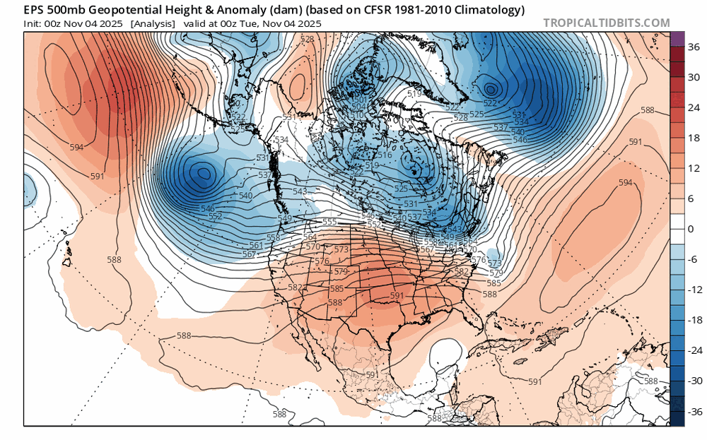
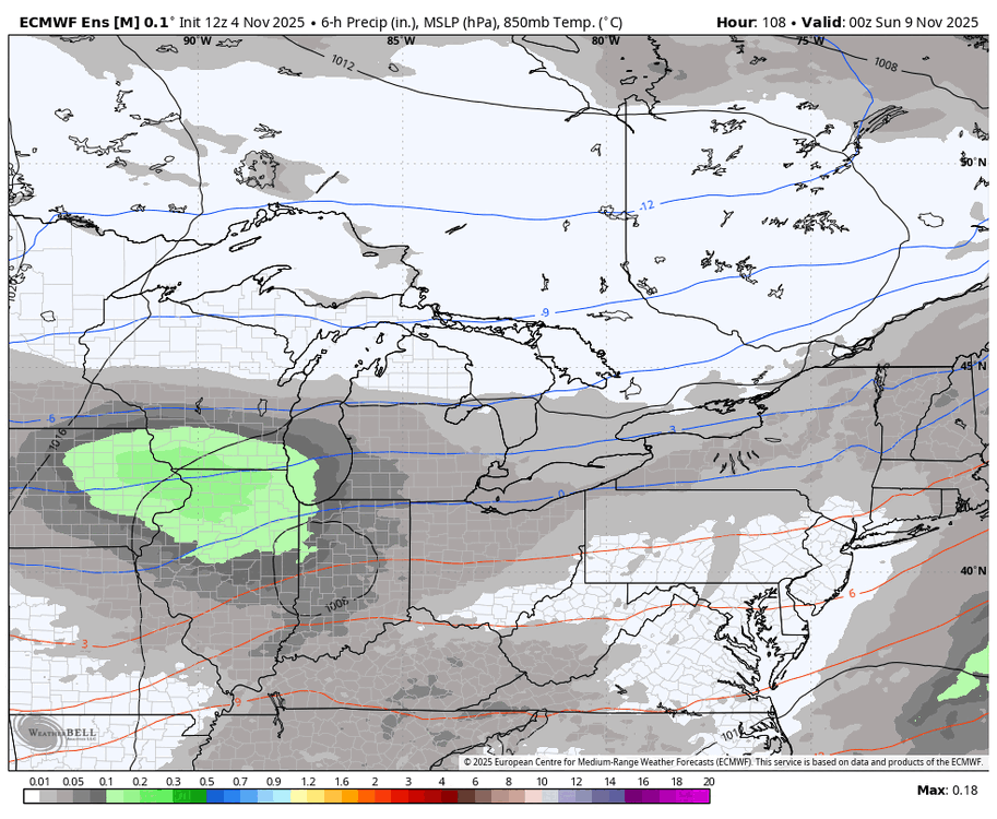
At this point, I am definitely "in" on accumulating snow somewhere across the snowbelt to start next week. It is short lived, but there will be a nice pattern amplification this weekend into the beginning of next week. That will send a chunk of the PV currently up over the arctic circle south into the Great Lakes Sunday and Monday: While details are of course going back and forth on the latest deterministic model runs as they will at this range, the ensemble mean SLP, 850mb temperature, and QPF loop is a pretty good look for lake effect: There may be some wet snow with that little wave of low pressure on Sunday depending on where it tracks...however, the lake effect ramps up behind it Sunday night into Monday, and probably lingers into Tuesday before ridging and warm air advection really start kicking in. Ensemble mean 850mb temps are down around -9C on Monday, with the ensemble mean depicting nice cyclonic flow across the Great Lakes and suggesting a more west to northwest wind direction. 500mb temperatures are progged to bottom out between -35 and -40C over a lake that is currently about 12C, which suggests very strong and deep instability is in play, potentially enough for thunder and lightning. We'll need to see how the specifics evolve as it gets closer, but the ingredients are there for a (somewhat brief) period of intense lake effect centered around Monday of next week, and the airmass should be cold enough for accumulating snow if we're able to get any sort of organized activity...which seems likely.