All Activity
- Past hour
-

2026 Mid-Atlantic Severe Storm General Discussion
SnowenOutThere replied to Kmlwx's topic in Mid Atlantic
SPC has us in a day three marginal risk which prompted me to take a look NAM has a line of broken storms enter the region after a bit of clearing with 1000 CAPE values running right along I-64. We have 40-50kt of bulk shear and a good bit of lower level turning. Reminds me a bit of March 15th but less extreme and maybe a bit more heating. Wonder what yall think about it -
The rain gives it a certain vibe. I don't mind it when I'm walking around UVA.
-
Early to Mayorch 10 or so is normal here for Oaks . They leafed out early last week
-
I picked up 0.48" from the solid rain shield this morning. My April total is 7.19".
-

Potential Sever Weather Outbreak 4/27/2026
SchaumburgStormer replied to pen_artist's topic in Lakes/Ohio Valley
Game over for 72 north, but digging the rain -
remember these?
.thumb.png.122b0a0ff0d363266ed531b083d0ff20.png.43f05d63be8df057a4b26e7c0af599b4.png)
-
Lolz. A day or two maybe. https://www.usanpn.org/data/maps/spring
-
Pushing 70 now…absolutely prefect out there.
-
Or any day, period.
-
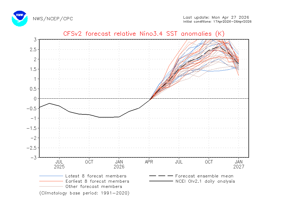
I have the most recent CFS RONI mean peak at near the 1982-3 record of +2.5 rather than +2.7: It is the monthly of Nov that peaks near +2.7, which is near the 1982-3 monthly peak of +2.69 (Jan peak): So, the most recent CFS has warmed to a 1982-3 redux in strength.
-
Average is generally low-mid 60's in early May
-
Well, Sunday looks ruined again. F
-
isn't that the average high for your area in the first half of May? I don't think we're much higher here...I'll take 70 and sun any day in May
-

2026-2027 El Nino
snowman19 replied to Stormchaserchuck1's topic in Weather Forecasting and Discussion
If the new CFS has a clue, there may not be a big disconnect between the traditional ONI and the RONI. It has the RONI peaking at around +2.7C and the traditional ONI peaking at around +3.1C in the November/December time frame. If (IF) correct, it would set a new RONI record, which currently stands at +2.5C for the 1982-83 super El Niño -
yeah i'd say this map from May - August is jackpot. Very comfortable.
-
53° feels like 65, given how many days we've had in the 40's this month
-
Officially in the hatched risk zones for tonight. We'll see what Dickson County gets out of all this. Should be a wild ride with little to no sleep! Also, it will be interesting to see what damage survey teams obtain in their assessments with so much of the mid-state plagued by severe drought post-ice storm. That's the sneaky fly in the ointment in all this. 50-60 mph winds may have more of a 60-70 mph effect.
- Today
-

Potential Sever Weather Outbreak 4/27/2026
Jackstraw replied to pen_artist's topic in Lakes/Ohio Valley
Tor warning near Taylorville IL embedded in that very shrimpy looking bow in Central IL. Right on top of my friend over there. Said he hasn't even left the parking lot. He's going to head S/SW and get into the clearing out warm sector. Think that area is where the best potential for some explosive cap busters. -
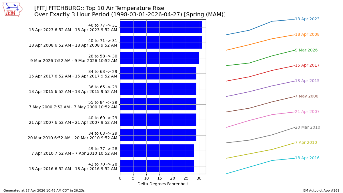
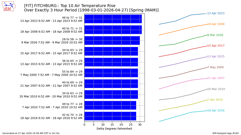
ASOS era, spring highest, 3hr rises for FIT
-
2026-2027 El Nino
snowman19 replied to Stormchaserchuck1's topic in Weather Forecasting and Discussion
I agree that we are going to see big warming coming up with the massive DWKW that has just begun propagating east from the WPAC and the continued WWBs. Also, already seeing signs of a strong +IOD forming with the robust cooling around Australia. That’s going to constructively interfere with the ongoing Nino development/Bjerknes feedback -
I wonder if the threat moves even further south based on where the current precipitation and outflow boundary is.
-
67° SKC
-

Occasional Thoughts on Climate Change
WolfStock1 replied to donsutherland1's topic in Climate Change
No offense but - seems like you ought to know such things if you're posting so much on the subject. It's hard not to be skeptical of the data you post otherwise. If it's just a general global singular heating trend - shouldn't we just cross 16C once or twice and be done with it, forever more above that level? (Aside from ENSO, which would cause us to cross that level a couple of times during the transition) -
We agree that temps will very likely warm notably more rapidly due to this incoming likely strong El Niño as has occurred with past ones. But if a strong Nino in itself leads to a temporary more rapid warming, isn’t that consistent with this additional warming being due to a natural oscillation of the Pacific ocean rather than GW from AGW? Strong El Niños lead to more rapid jumps in global temps. That more rapid warming in itself is due to a natural oscillation, ENSO, bringing to the surface the even warmer water. Is this right?
-
Oh I thought you were back . I’d bet your Oaks are close. About 10-14 days early here this year. That week of 85-90 made all the difference


.thumb.gif.f92b16c631a1d15d405ed77b33f0710d.gif)