All Activity
- Past hour
-

Nov 28-30th Post Turkey Day Wintry Potential
sbnwx85 replied to Chicago Storm's topic in Lakes/Ohio Valley
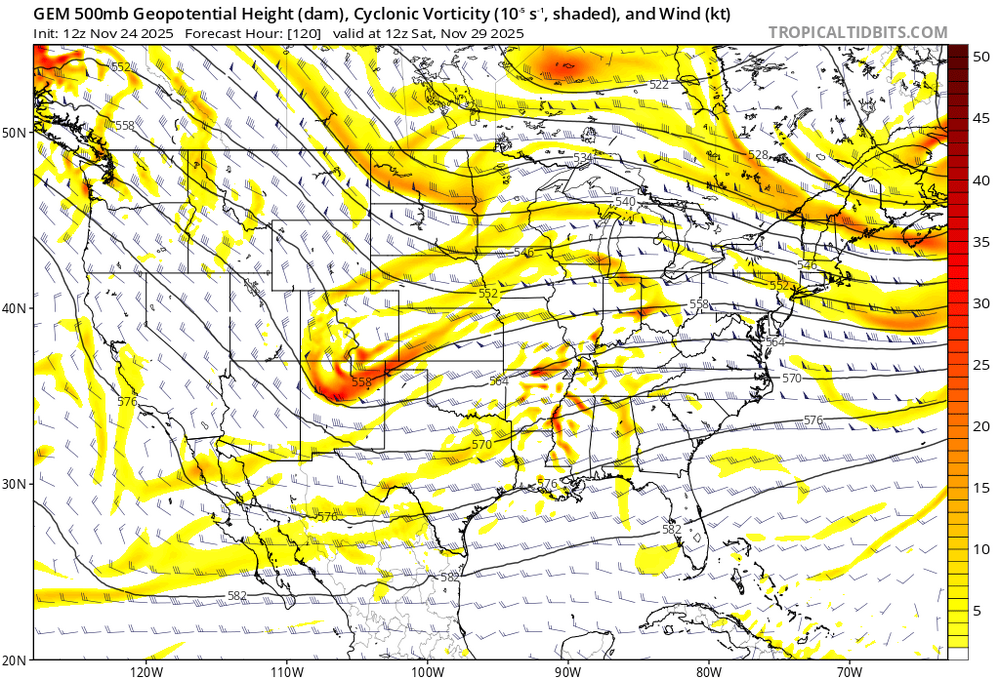
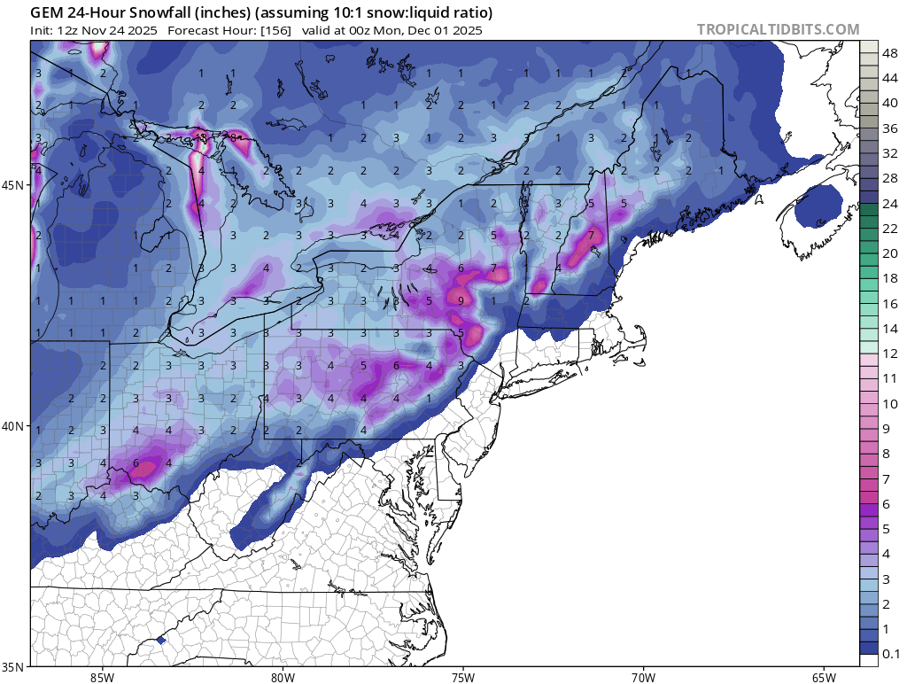
IWX favoring the foreign solutions early on. Friday through Monday... Some lake effect is likely to linger into Friday, possibly briefly shifting into NW Indiana for a period until the low level ridge axis finally passes through Friday night in response to the next area of low pressure taking shape. While models remain in agreement on a baroclinic zone establishing itself across the area over the weekend, timing and ptype issues persist, leading to an uncertain forecast for those likely travelling home from the holiday weekend. EC/GEM brings in precipitation during the day Sat with temp profiles cold enough for all snow through Sat night before shifting east. GFS delays precip till at least Sunday and maybe not till Monday, which would suggest more of a mix to possibly all rain. The current forecast leans towards the faster solution at this time with likely pops Sat/Sat night. As would be expected this far out, confidence in finer details is not overly high but worth watching. -
Wow, this is very impressive. Thanks for putting this together. I only had enough ambitions to do some seasonal maps and a few bigger storm maps. Doing most major storms for this long of a period is not only very impressive, but it excellent for preserving good records of storms. As the memory of those storms fade (and sadly the people who remember those pass on), we only have whatever was archived to look back on.
-

Nov 28-30th Post Turkey Day Wintry Potential
Radtechwxman replied to Chicago Storm's topic in Lakes/Ohio Valley
Funny GFS was the one being aggressive with this before and euro not as much now gfs barely has anything and Euro has really uptrended. Definitely keeping my expectations low. At least we got an active pattern ahead. -
Positive steps today on the models. It's not like we aren't seeing Positive trends here. Especially when considering the MJO is moving in the right direction. Yeah this current weather sucks but hey the colds coming.
-
Two days in a row of positive baby steps with the long range guidance. What makes me more optimistic is how many times CAD has shown up in some of these runs. Even in a mediocre pattern, an active gulf and a well timed CAD can do the trick. I don’t think a blow torch is a sure fire bet anymore. It seems like we’re correcting back to volatility and some AN temps but possibly trending more towards Avg with stout below avg bouts.
-
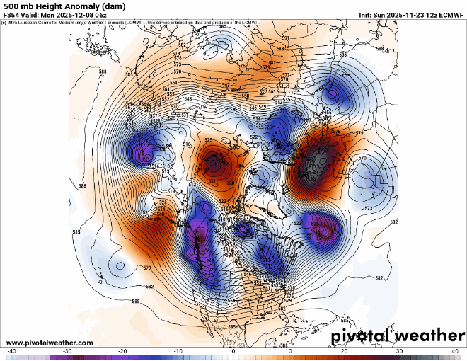
The significant trend the models have been showing for early December is more of a Southeast ridge. Of course every run is going to show the departures on any given day being a little different when we are talking week 2 modeling. Some days the ridge will pulse up and others pulse down. But the continuing very fast Pacific flow will continue to limit or storm track options at least into early December.
-
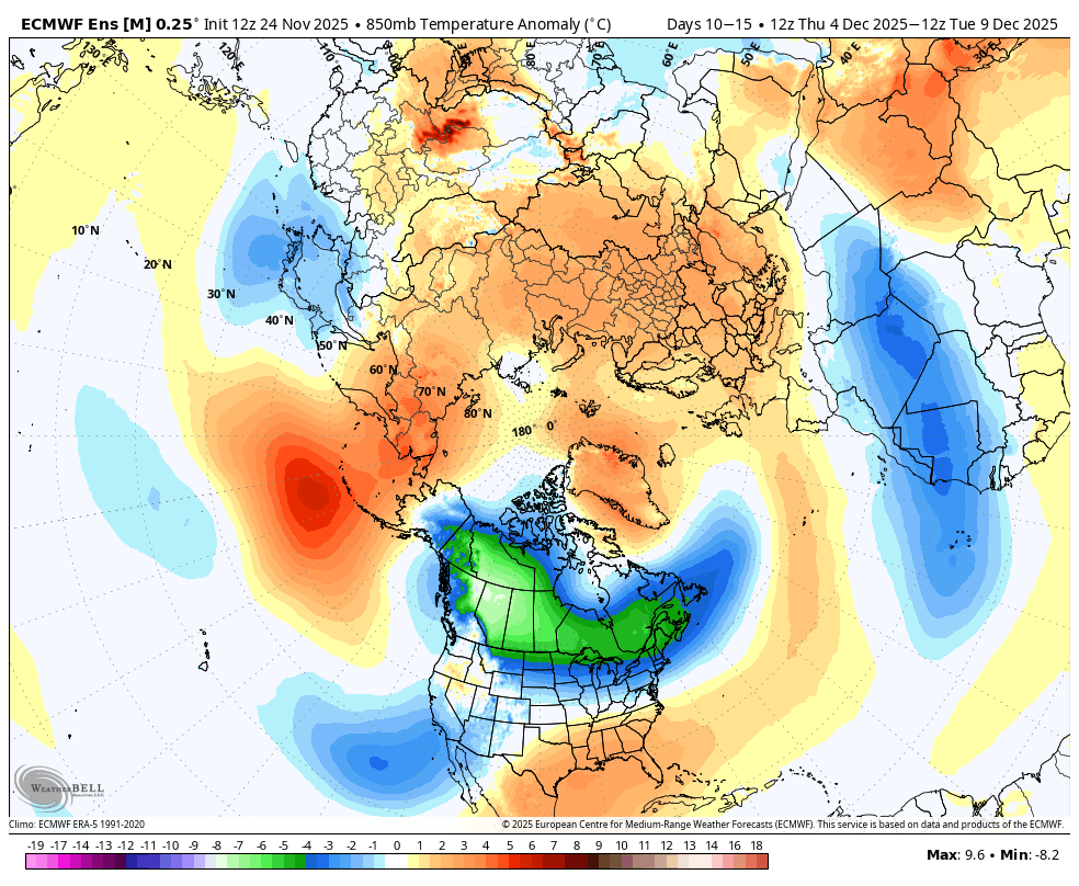
The most anomalously cold air in the entire northern hemisphere will reside in Canada, allowing the northern tier of the Eastern US to stay somewhat cool despite the -PNA.

-
Euro is also close. Need the PV to squash the heights.
-
The I78 Deathband event in PA, NJ, and parts of the city. It was like a synoptic scale lake effect streamer. The town south of me had 6” on the north end and 10” on the south end (5 minute drive). Similar in parts of NJ.
-
Thats not the point. The point is that many were posting how mild it is going to be. We just saw on the 12z runs how different they are with the warmup for early December. They look good for early December. How do you know what the storm track will be ? All we can do is track it but a favorable pattern is coming up as the mjo heads into 8 in December. Alot of doubters on here. Its fine but at least admit when posters claim its going to be warm but then it turns out cold.
-

November 2025 general discussions and probable topic derailings ...
WinterWolf replied to Typhoon Tip's topic in New England
That’s just like the house I grew up in…front yard and front door faced due east too. So our backyard was due west. My room faced the front(East), but I had a side small crank out window that faced due north…in rain changing to mixed precip events, I’d run to my room to listen for any pingers on that north side, if we were forecast to change over. That window would give the first signal of any change over lol, and it took a hell of a beating. Sounds great Don…enjoy your time at both places. -
I'm rooting for this day 5 shortwave on the CMC. It gets closest to a wintry outcome in the mid-range. I always root for mid-range instead of long-range fantasy-land. There's not much support on the ensembles, unfortunately. The ICON and UKMET might get a few flakes to the area, but everything is north and/or weak. I don't even want to consider day 10+. Too unreliable.

-
It’s less important what the long range models are showing since that can vary from run to run. But the long range forecast biases for each type of regime remain more constant over time. Plus the inability of the models to see seasonal repeating patterns until the actual pattern is getting close to occurring.
-
possible tornado by Jersey Village TX (Houston area)
-
Beautiful afternoon to put up Christmas decorations!
-
this place will be a mess on 11/25...
-
Change of Euro OP over last 3 runs for late period I figured it was worthy to mention since some of the other runs were.
-
Same storm track pattern heading into December. Great Lakes cutter, I-78 to I-84 hugger, and suppressed Southern Stream. Plus we haven’t had a gradient pattern work for us in over a decade.
-
This is great. Thanks!!
-
 I’ll still be there most of the time. We have a house I don’t want to sell anytime soon. EH is still home for me, and I have work (obviously fairly flexible) and my elderly mom. Wife and I will just figure out next steps. Six months ago none of this was even imaginable. My life has been a roller coaster since my dad passed in 2021. Lots of twists and turns. I think this is a good one though. fair I mean I’m talking about this as it’s -SN under partly sunny skies and 34°. I became PF in less than an hour. Only us weenies would think about this stuff lol. Front door and yard faces due east. When we originally looked at the place my wife was wondering why I spent so much time looking at the trees. “Need to know if a westerly wind will put a tree in the bedroom”
 -

November 2025 general discussions and probable topic derailings ...
Torch Tiger replied to Typhoon Tip's topic in New England
-
At least drought conditions should improve
.thumb.png.c7e8fb71c4ba43e24d1e231d65eb7df4.png)
-

December 2025 Short/Medium Range Forecast Thread
Carvers Gap replied to John1122's topic in Tennessee Valley
I have repeatedly watched the deterministic GFS lead the way over other deterministic and ensembles at this time of the year(during past winters). It maybe doesn't do that as we get later into winter, but it seems to do a little better(than other models) during late shoulder season and early winter. I do admit ensembles carry more weight, but a lot of those ensemble members are cold. At the very least, some very cold weather is not out of the realm of possibility. And if the trend continues during future runs, those ensembles will flip. Fun 12z suite for sure. Pretty big cold signal for Dec 3 and/or Dec 6. -

Central PA Fall Discussions and Obs
WmsptWx replied to ChescoWx's topic in Upstate New York/Pennsylvania
Half a million people under tornado warning in Texas. - Today
-
No idea if it is any good at all, but 12z euro AI ensemble mean snow is 2-3” through the metro area through D15.


.png.e9b382ca2c3521af698fb767a9e78d47.png)
