All Activity
- Past hour
-
 Obviously this isn't going to impact many posters here and the population density isn't as high, however, this potential is deserving of its own thread. The potential exists for a rather significant severe weather event either late Tuesday afternoon or evening/overnight across northern New England. Daytime temperatures are expected to climb well into the 80's within the region and probably some spot 90's with dewpoints pushing into the lower 70's. This combination under the presence of an elevated-mixed layer characterized by mid-level lapse rates on order of 7+ C/Km will result in an extremely unstable atmosphere with MLCAPE values pushing or exceeding 3000 J/KG. While the timing of this event may be more evening or overnight, instability values will drop off due to the loss of daytime heating, however, MLCAPE values should remain around 1500+ J/KG. With the region on the northern periphery of a stout mid-level ridge that is centered over the northern Plains, strong flow will overspread the region with 60-70+ knots of 500mb flow, aiding in the potential for bulk shear values exceeding 50 knots. In addition, a strong surface cold front will be diving south. The combination of instability and wind shear ahead of the approaching cold front will set the stage for the development of one, or perhaps multiple clusters or lines of thunderstorms across Quebec which propagate across northern New England late in the day or during the evening or overnight. Given the ingredients, the potential exists for a concentrated swath of damaging wind gusts (perhaps some significant wind gusts), and if any supercells develop there will be a risk for large-to-very large hail, and even the risk for a few tornadoes (though this is largely dependent on storm mode and whether surface winds can remain more southerly ahead of the front.
 -
 The first 15 days of August 1988 were brutal in New England. I think I had 13 of 15 days AOA 90 and the other two 89. Then a strong cold front came through and the rest of the month avg slightly below for temps.
 -

2026-2027 Super El Nino
snowman19 replied to Stormchaserchuck1's topic in Weather Forecasting and Discussion
“40 knot westerly wind anomalies potentially emerging right over the warmest water east of the dateline. The synoptic elements are too small scale to be accurately predicted here. What it's indicating is enhanced risk of seasonally extreme equatorial westerlies through the middle and into the end of July.” -
 00z euro was really hot up here. 12z gfs goes from 24C to 0C up near CAR. Could be a couple chilly nights for the rad pits.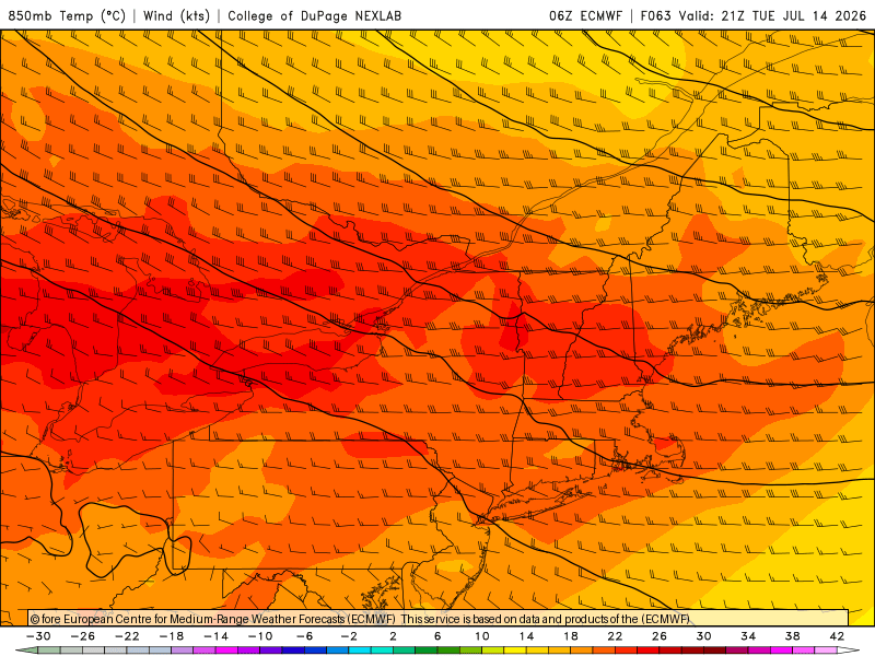
-
If you play hoops, then you know that this is goat-level weather (near 80, mostly cloudy/partly sunny, and mostly calm winds). I loved the desert sun, but it was breezy (unusually breezy) and obviously dry almost every day.
-
.thumb.gif.f92b16c631a1d15d405ed77b33f0710d.gif) Zero staying power though
Zero staying power though -
Yep - it’s always the most likely scenario when outlooked that far out. Things will almost always trend earlier or later and either direction can of course be worse for timing.
- Today
-
Raining hard here again- every day since July 4 has now had measurable rainfall IMBY
-
 Nice day for business suits. Up to 75F already from a low of 48F.
 -

Central PA Summer 2026 Discussion/Obs Thread
Blizzard of 93 replied to Voyager's topic in Upstate New York/Pennsylvania
My dew point is finally down to 68 now. I am really looking forward to the brief break today from the swampy conditions before the extreme heat returns mid week. -
Currently 78 in town (even on the shoreline), 80 at the TH arprt @ 9:30 am. And so it begins. Lets see if we can hit 100 in the area. WX wise that'd be awesome. Practically, ISH!
-
 Keeping an eye on Tuesday night up here in Maine for bangers. Hopefully the timing can speed up to take advantage of max instability because other parameters are impressive.
 -
Should have a nice long break from mowing in about a week or so as the lawns will start to fry up. Already been over a week without a drop of rain, and a long string of 90s on the way.
-
July 12 1863: Unseasonably cool temperatures are felt across the state. Frost is reported in the Twin Cities area. For Sunday, July 12, 2026 1951 - The Kaw River flood occurred. The month of June that year was the wettest of record for the state of Kansas, and during the four days preceding the flood much of eastern Kansas and western Missouri received more than ten inches of rain. Flooding in the Midwest claimed 41 lives, left 200 thousand persons homeless, and caused a billion dollars property damage. Kansas City was hardest hit. The central industrial district sustained 870 million dollars property damage. (The Kansas City Weather Alamnac) 1980 - Lightning struck a large broiler house in Branford, FL, and the ensuing fire broiled 11,000 nearly ready broilers. Firemen were able to save a few thousand chickens, however. (The Weather Channel) 1987 - Cool air invaded the High Plains Region. Eight cities reported record low temperatures for the date, including Sheridan, WY, with a reading of 37 degrees. Thunderstorms developing along the cold front in the central U.S. produced 6.5 inches of rain at Fort Dodge, IA, and 2.5 inches in one hour at St. Joseph MO. (The National Weather Summary) 1988 - Evening thunderstorms produced severe weather over the Dakotas, including baseball size hail at Aberdeen, SD, and softball size hail near Fullerton, ND. Thunderstorms produced heavy rain in Arkansas and northeastern Texas, with 6.59 inches reported at Mesquite, TX, in just an hour and fifteen minutes. Garland, TX, reported water up to the tops of cars following a torrential downpour. (The National Weather Summary) (Storm Data) 1989 - Early morning thunderstorms over eastern Kansas deluged McFarland with more than six inches of rain. Afternoon thunderstorms in Wyoming produced up to eighteen inches of dime size hail near Rock Springs, along with torrential rains, and a three foot high wall of mud and water swept into the town causing more than 1.5 million dollars damage. Evening thunderstorms produced severe weather in Oklahoma and Arkansas, deluging Dardanelle, AR, with 3.50 inches of rain in less than twenty minutes. About seventy cows were killed when lightning struck a tree in Jones County, TX. (The National Weather Summary) (Storm Data) Observances: 12 Sun National Simplicity Day 12 Sun Malala Day 12 Sun Orangemen's Day (The Twelfth) 12 Sun Etch A Sketch Day 12 Sun National Different Colored Eyes Day 12 Sun National Eat Your Jello Day 12 Sun National Hair Creator’s Day 12 Sun National Pecan Pie Day 12 Sun National Tile Repair Day 12 Sun New Conversations Day 12 Sun Night of Nights 12 Sun Paper Bag Day
-
97, 98, 95 today, tomorrow, and Tues. 75 in the house atm. Looks like WSW light wind the coming days, so that should keep the shoreline pretty warm, too.
-
 Chilly??????????
 -
https://www.spc.noaa.gov/products/exper/day4-8/# ... Friday/Day 6 -- Mid-Atlantic Region ... This evening's deterministic guidance suite (20260712 00 UTC), along with yesterday morning's deterministic guidance suite (20260711 12 UTC), is faster moving the surface boundary south than last night's guidance suite (20260711 00 UTC). However, the overall ensemble guidance continues to suggest severe potential across the region, owing to differences in the position of the surface boundary and the timing of mid-level vorticity maxima. Severe probabilities (15%) have been retained with this forecast in a nod to the ensemble guidance suite, but if the current trend of pushing the surface boundary farther south on Thursday (Day 5) continues, severe weather probabilities may need to be removed as the surface boundary will push south of the better deep-layer shear. ..Marsh.. 07/12/2026
-
https://forecast.weather.gov/product.php?site=PHI&issuedby=PHI&product=AFD&format=CI&version=1&glossary=1&highlight=off KEY MESSAGE 4...Friday could be active and unsettled with a chance for showers and thunderstorms, some of which could be severe. We are still several days out but we are monitoring the severe weather setup on Friday. The Storm Prediction Center (SPC) has highlighted most of the area in a Slight Risk (15% chance of severe thunderstorms 25 miles from any point). Storms look to be driven by a strong cold front swinging in from the northwest and with ample daytime heating and instability, the ingredients are certainly there for strong to severe thunderstorms and damaging wind gusts. In their long term outlook, SPC did mention some small MCS potential during the day 7 to 10 period as some shortwaves are likely to ripple through the northwest flow. Again, still several days out, but we will have to monitor the severe weather potential for the end of the week and possibly next weekend.
-
Rare severe storm over the Keweenaw coming in from the nw has held severe intensity since Isle Royal. Usually the cold water is a death nail to storms. Hopefully it holds together as it approaches the n shore of Marquette County. A storm would be nice to kick off the heatwave.
-
Newark came closest in July 1966 reaching 100°. So the number to watch will be 101°+. All the other years stayed under 100° in the following 15 days of 104°+. July 1949 made it back to 101° on the 28th which was 24 days after. 1966-07-03 105 75 90.0 12.6 0 25 0.00 0.0 0 1966-07-04 100 78 89.0 11.5 0 24 0.00 0.0 0 1966-07-05 87 74 80.5 2.8 0 16 0.00 0.0 0 1966-07-06 87 73 80.0 2.2 0 15 T 0.0 0 1966-07-07 93 76 84.5 6.6 0 20 T 0.0 0 1966-07-08 91 70 80.5 2.4 0 16 0.00 0.0 0 1966-07-09 89 67 78.0 -0.2 0 13 0.00 0.0 0 1966-07-10 93 70 81.5 3.3 0 17 0.00 0.0 0 1966-07-11 96 72 84.0 5.7 0 19 0.00 0.0 0 1966-07-12 98 72 85.0 6.6 0 20 0.00 0.0 0 1966-07-13 100 77 88.5 10.1 0 24 0.00 0.0 1949-07-04 105 74 89.5 12.0 0 25 0.08 0.0 0 1949-07-05 95 73 84.0 6.3 0 19 0.00 0.0 0 1949-07-06 83 68 75.5 -2.3 0 11 0.47 0.0 0 1949-07-07 81 64 72.5 -5.4 0 8 0.06 0.0 0 1949-07-08 81 65 73.0 -5.1 0 8 0.00 0.0 0 1949-07-09 81 61 71.0 -7.2 0 6 0.00 0.0 0 1949-07-10 76 64 70.0 -8.2 0 5 0.13 0.0 0 1949-07-11 86 67 76.5 -1.8 0 12 0.00 0.0 0 1949-07-12 81 69 75.0 -3.4 0 10 0.17 0.0 0 1949-07-13 85 69 77.0 -1.4 0 12 0.56 0.0 0 1949-07-14 91 67 79.0 0.5 0 14 0.00 0.0 0 1949-07-15 80 71 75.5 -3.0 0 11 0.22 0.0 0 1949-07-16 81 71 76.0 -2.5 0 11 0.00 0.0 0 1949-07-17 75 70 72.5 -6.0 0 8 1.17 0.0 0 1949-07-18 93 70 81.5 3.0 0 17 T 0.0 0 1949-07-19 94 72 83.0 4.5 0 18 T 0.0 0 1949-07-20 94 74 84.0 5.5 0 19 0.00 0.0 0 1949-07-21 94 77 85.5 7.0 0 21 T 0.0 0 1949-07-22 97 75 86.0 7.5 0 21 0.01 0.0 0 1949-07-23 90 71 80.5 2.1 0 16 0.00 0.0 0 1949-07-24 90 63 76.5 -1.9 0 12 0.00 0.0 0 1949-07-25 94 69 81.5 3.2 0 17 0.03 0.0 0 1949-07-26 88 71 79.5 1.2 0 15 0.00 0.0 0 1949-07-27 97 71 84.0 5.8 0 19 T 0.0 0 1949-07-28 101 75 88.0 9.8 0 23 T 0.0 0 1949-07-29 100 75 87.5 9.4 0 23 0.00 0.0 0 1949-07-30 101 75 88.0 9.9 0 23 0.05 0.0
-
Its probably a good idea to invest in a window air conditioner. They aren't that expensive and even on days when it just hits 80 you can turn it on for a bit. I rarely ran my AC the last 3 weeks of June. I had it set to 80 when I was in Alaska and then when I got home I turned it off the next 2 weeks. Turned it back on ahead of the June 30-July 3 heatwave and havent had it off since.
-
 Man those are really toasty 850 temps Tuesday night. Too bad we couldn’t time that earlier or on Wednesday.
 -
Yeah 1993 , 2011 came the closest for that criteria but not quite in the 15 day range. Will be interesting and will the next heat spike east in the 7/23 - 7/30 timeframe .
-
 Hopefully brings some storms. This dry stretch that started Wednesday last at least into next weekend will be the final nail for lawns
 -
This will be the first 101°+ potential less than 15 days after 104°+ during July and August.