All Activity
- Past hour
-

2026-2027 Strong/Super El Nino
40/70 Benchmark replied to Stormchaserchuck1's topic in Weather Forecasting and Discussion
Yea, I don't even think it's worth sweating those details....usually when it gets this powerful, it's safe to just concede warmth on par with an east-based event. But there are other factors that could foster the development of a favorable stretch(es), especially later in the season. -
48 was lower than I imagined we would be last night. huh. Considering machine numbers tickle the chode hairs of 90, a 40+ is gonna challenge some delta records for the date.
-
good line of higher CAPEed convection 21z on Saturday outta do the trick.
-
You guys got me searching obs…saw this for the first time… KMWN 032352Z 29017KT 85SM FEW180 FEW200 SCT220 10/04 RMK SUN DOGS 10111 20099
-
Need a METAR code for pollen now BLPN
-
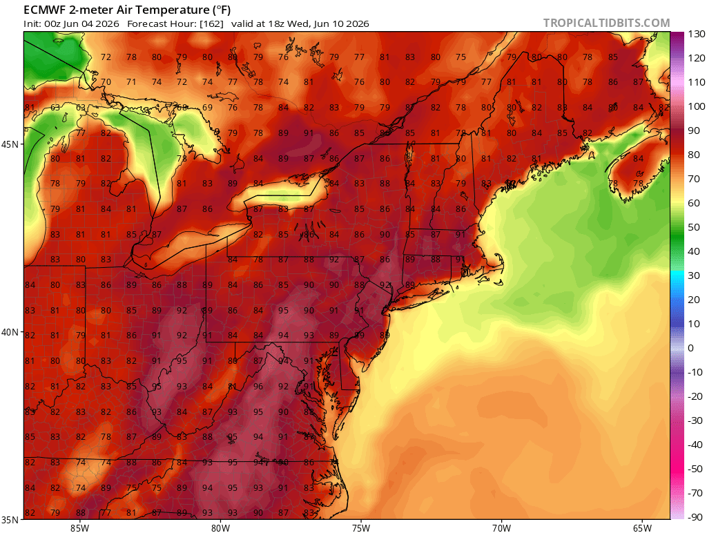
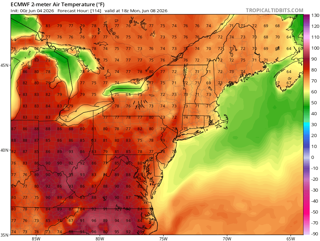
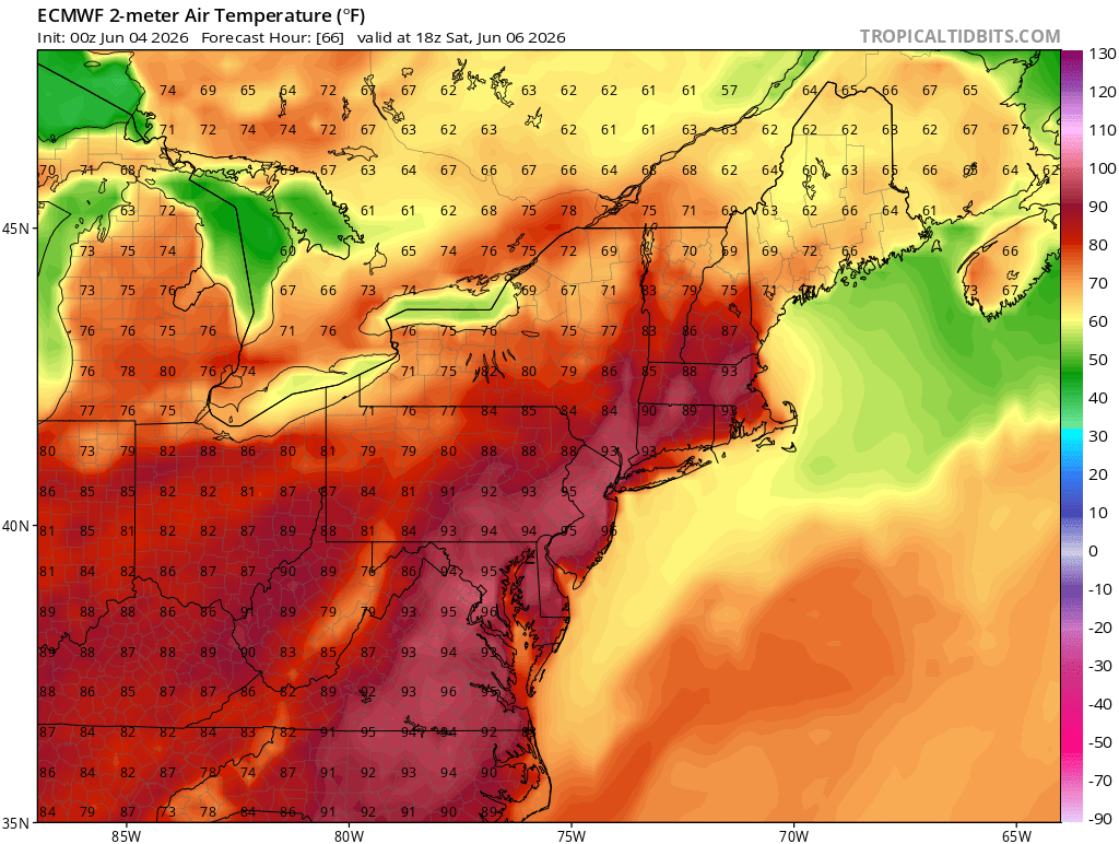
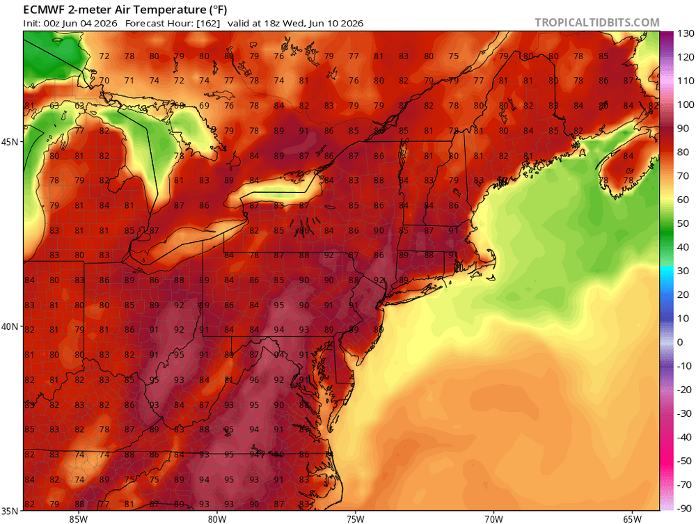
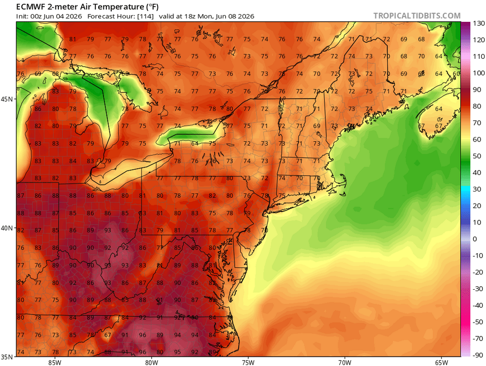
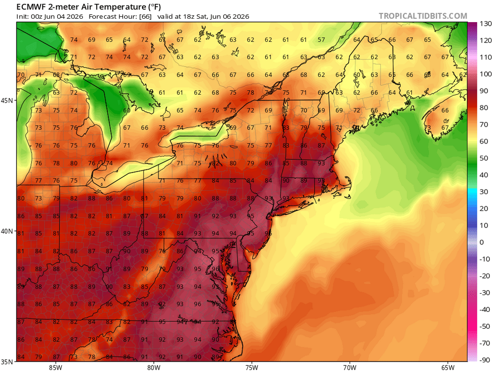
Very warm early June pattern with 90s next few days then a pullback and more 90s next week. As we saw with the early 100° heat back in May, this is warmer going into at least the early summer than past super El Niño events The extensive nature of the +30C warm pool from the IO over to the PMM region has resulted in competing Niña-like and Nino-like influences. The warmest days are what we typically see with La Niña early in the summer. The recent cooler from the Memorial Day weekend to a few days ago were more Nino-like. But the warmer days were of a higher magnitude than the cooler days were. Some spots set or tied their all-time May monthly maximum temperatures. It could also be the drought feedback across the CONUS is contributing to this unusual early summer warmth for a super El Niño. Plus these are our first super El Niños only 3 years apart leading to another global baseline temperature jump over such a short period of time.
-
kinda like vaccines, amirite?
-
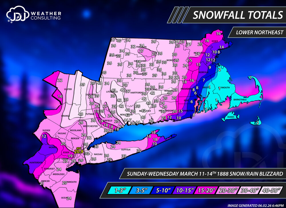
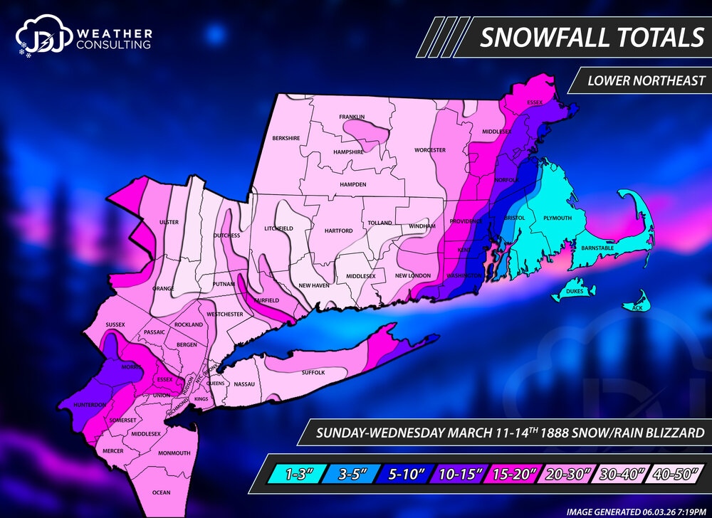
With the help of @Suchit0623 i have remapped the Blizzard of 1888 with 168 new snowfall reports from NWS COOP, climate sites and Judd Caplovich's book "Blizzard! The Great Storm of 1888." The general idea of the snowfall distribution is about the same but with significantly more reports i was able to really narrow down banding especially in CT along with the sharp cut off in E MA. The subsidence from the intense bands in central CT and LHV showed up nicely in a relative screw zone from SW Fairfield to Putnam/Dutchess where amounts dropped off from 40-50" to <20" in a narrow area. Reports were very thin in S NY and NJ unfortunately. Southern New England, Tri-State and CT maps are up as well. https://www.jdjweatherconsulting.com/mar-11-14-1888
-
Huge snowstorms in this area were 1979, 1983, 1987, 1993 (some parts), 1996, 2000 (some parts), 2003, 2010 and 2016. We are way overdue for a home run monster.
-
Before seeing this sort of stuff, and like that car interior last year, I never really appreciated not having them here. What a menace.
-

2026-2027 Strong/Super El Nino
bluewave replied to Stormchaserchuck1's topic in Weather Forecasting and Discussion
MJO 7 is the bridge between the super El Niño and the WPAC warm pool. So we get an extended +30C warm pool from the IO over to MJO 7 and Nino 4. It’s even possible that the 30C warm pool could expand closer to Nino 3.4 by later in the fall. Plus the +30C warm pool associated with the record +PMM to the north of Nino 1+2. We began to see MJO 4-6 activity for the first time with a super El Niño in December 2015. As the warm pool expanded by the 2023-2024 super El Niño into the IO, we had record MJO 3-7 activity with a super El Niño. Multiple papers have bee published on this more active MJO from the IO into the WPAC. Previous events had seen the MJO go quiet in these passes during super El Niños through the 1997-1998 event. They even released a paper calling it dual forcing back in 2023-2024 due to how large the warm pool had grown. All this extended oceanic heat that was released jumped the global baseline higher than the models forecast. So getting another baseline temperature jump only 3 years later will be a first for our modern climate.
-
Another incredibly cool morning for June, 53. It is going to be wild having lows in 50s and highs in 90s next couple days
-
 It’s continuing to trend a little faster so now it’s slightly favorable again on Saturday late evening
 - Today
-

Central PA Summer 2026 Discussion/Obs Thread
pawatch replied to Voyager's topic in Upstate New York/Pennsylvania
47 degrees for the low. Mostly Smallmouth under 12” yesterday…post spawn. Beautiful day! -
Low of 45 this morning. Man this weather is fabulous.
-
Not really, there is something called seasonal lag, which is why the hottest days on most years are deep into July, sometimes in early August. Besides, the days have noticeably stopped getting longer, especially on the morning side. At night, it is still getting light later. By around June 13-14, most places in this area will have seen their max daylight (it might still be technically getting longer by a second or two, but that's junk change when you have 15 hours of daylight), and that will go on until about June 26-27.
-
I actually drove right by KBED yesterday. This makes sense as many many sneezes were had.
-
Wtf. This is getting annoying Sent from my SM-S921U using Tapatalk
-
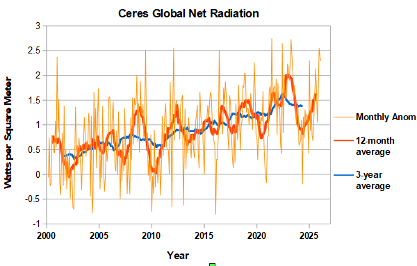
CERES net radiation through March. At high level in March, similar to February. Probably close to peak for this ENSO cycle.
-

2026-2027 Strong/Super El Nino
snowman19 replied to Stormchaserchuck1's topic in Weather Forecasting and Discussion
Latest SOI: -35.29 In other news, this El Niño has become severely east-based. There are confirmed, historic anomalies of +7.2C off the coast of Peru in region 1+2, which is a new all time record, surpassing both 1997 and 1982. And as @Gawx predicted, very rapid warming of the SSTs in region 3.4, OISST ONI: +1.2C, RONI: +0.73C. With this major WWB ongoing, it would not surprise me if we are into a high-end moderate/strong Nino (RONI/ONI) by the end of this month -
-

Central PA Summer 2026 Discussion/Obs Thread
mahantango#1 replied to Voyager's topic in Upstate New York/Pennsylvania
US National Weather Service State College PA Thursday - June 4, 2026 @ 430 AM EDT: High pressure drifting by just to the south of PA today will bring mainly sunny and warm conditions with comfortable/low humidity for our Thursday. The peak in temperature and heat indices will occur Friday with humidity creeping up a bit. Increasing west to southwesterly winds at the surface and aloft Saturday will combine with warm temperatures, higher humidity and an approaching cold front to bring scattered strong to potentially severe thunderstorms in the afternoon and evening. -
Central PA Summer 2026 Discussion/Obs Thread
mahantango#1 replied to Voyager's topic in Upstate New York/Pennsylvania
-

2026-2027 Strong/Super El Nino
TriPol replied to Stormchaserchuck1's topic in Weather Forecasting and Discussion
Save it for October! -

2026 Atlantic Hurricane Season
WxWatcher007 replied to Stormchaserchuck1's topic in Tropical Headquarters
We will see if the signal becomes more consistent in the coming days, but today was really the first where we saw a stronger signal for TC genesis in the Gulf across operational and ensemble guidance near that mid-month window.