All Activity
- Past hour
-

Mountain West Discussion
mayjawintastawm replied to mayjawintastawm's topic in Central/Western States
APA (Centennial Airport) is at 0.30" for the month, which I think is pretty typical for the immediate I-25 corridor (say 10 miles either side) north of Castle Rock. We're at 0.36" at my house. -
More eastern shore sites coming this week!
-
Mountain West Discussion
mayjawintastawm replied to mayjawintastawm's topic in Central/Western States
Beautiful fire prevention!! -
Not that I want H hits in the SE because I don’t as I’d love a boring shutout! But keep in mind that the lowest August temp since 2001 in RDU, GSO, ATL, and most major stations in TN/NC/SC/GA and some in AL was in early to mid August of 2004. That month had a 2-3 week long stretch of BN temps. The very next month had 3 bad hurricanes hit FL.
-
That was for SouthCoastMA and the clipper reference.
-
Don’t forget that August of 2004 had 2-3 weeks straight of BN.
-
46.4 this morning. Hopefully we don't pay for this in October.
-
Was 50 for the morning walk out of Monkton station with the dogs at 7 am.
-
Keep in mind that the lowest August temp since 2001 in RDU, GSO, ATL, and most major stations in TN/NC/SC/GA and some in AL was in early to mid August of 2004. The next month had 2 bad hurricanes hit the FL E coast and 3 in total in addition to Charley in that same August.
-
In 2025, one can just make something up, post it on social media, and others will believe it. Obviously, the Carr Fork Lake number is erroneous, and the 2012 occurrence at Greenup looks to be an error as well. In 1986 and 1946, clearly a number of stations observed lows in the 30s in Kentucky. In August 1986, nearly 1/4 of all NWS stations in the State had a low in the 30s. And this is just official cooperative stations, not backyard thermometers or mesonets or whereever that is sourced from. Kentucky's highest point is 4,145 feet. Those elevated valleys in the east can radiate well.
-
Models seem to create their own triggers sometimes… Probably just emergence of chaos in the model as it processes out in time. If the layout is numerically/physically unstable as an initial condition and then the model plunks down one of its little invented triggers in the midst of it we’re going to get these weird solutions like that faux “Bob“ thing … Along with a lot of posts about why it’s possible ha ha ha
-
I would tend to think right now that the ACE finishes lower than the 161 reading we got for 2024. But there are some similarities to last year so far. 2024 featured hurricane Beryl going CAT 5 in early July. Then no major hurricanes until late September. This year we got the CAT 5 Erin in mid-August and now it looks like perhaps no majors into at least mid-September. So my guess is that Erin won’t be the only major this year.
-
51.7 IMBY this morning. I was up at Fall Creek Falls Monday and Tuesday. I'm not sure what the low temp was Tuesday morning, but it felt like upper 40's. Excellent running weather.
-
Of note that 45.9 degree low temperature this morning at Warwick Township is the 2nd coldest temperature recorded in the county on this date behind only the 42 degree low back in 1944 at Phoenixville.
-

E PA/NJ/DE Summer 2025 Obs/Discussion
ChescoWx replied to Hurricane Agnes's topic in Philadelphia Region
Of note that 45.9 degree low temperature this morning at Warwick Township is the 2nd coldest temperature recorded in the county on this date behind only the 42 degree low back in 1944 at Phoenixville. -
 and the usual nonsense of posting day 7-10 maps showing 100 degree heat for mid August....
 -
45.1 this morning on my weather station
-

2025 Atlantic Hurricane Season
NorthHillsWx replied to BarryStantonGBP's topic in Tropical Headquarters
I know SSTs are still plenty warm obviously as we approach peak season, but sea temps have fallen across all of the western Atlantic and Caribbean and most of the gulf. A lot is due to Erin in the Atlantic but a lot is due to the train of fronts making very far south for this time of year. In NC many areas woke up to 50s this morning and 60’s made it down to the gulf coast. With more fronts on the way it begs the question of whether SSTs have already peaked in the western Atlantic and whether if a storm approaches that this will help mitigate high end intensity. It is quite literally a 180 from the start of season -

2025-2026 ENSO
PhiEaglesfan712 replied to 40/70 Benchmark's topic in Weather Forecasting and Discussion
The problem with that is many of those seasons were active early, or at least showed signs. 2022 and 2015 are the only one's you could make an argument against, and even those had activity in early September. If the first half of September is not active, then chances are, it just isn't meant to be this year. And that's okay, not every hurricane season is going to be active. Look at 1992 after Andrew, nothing happened in the first half of September, and the rest of the season didn't have a major storm (just 2 Category 2's, in Bonnie and Charley in late September, but nothing close to being as big as Andrew). Erin is almost certainly going to be the big event of the season. It's possible we get a second big storm (like we did in 2007 with Felix), but we're not going to churn out major storm after major storm like in 2005. -
 There were 5000 high posts mixed in with people crying that NYC only got to 99
 -
This is incredible. I hope everyone is enjoying this stretch of weather this is a historically cool period in the middle of summer. We may never get an extended BN stretch like this again for this long as so very few have ever happened. RDU hit 90 1 time in August and many areas in our sub forum never touched it and it is continuing into September. This realistically is likely the coolest extended summer period in many of our lifetimes. Not only the peak departures from normal but the duration of BN is what is making this period stand out
-

September 2025 OBS-Discussion centered NYC subforum
Stormlover74 replied to wdrag's topic in New York City Metro
Euro still has a storm next week but not until Wednesday now. Given its track record of late and no other model support I'd say its a long shot -
Oh I meant that coastal thing
-
First 50’s of the season! Well it’s not even close to fall and we have 50’s anyway! 58.6 this morning and honestly could’ve used a light jacket taking the kids to school
-
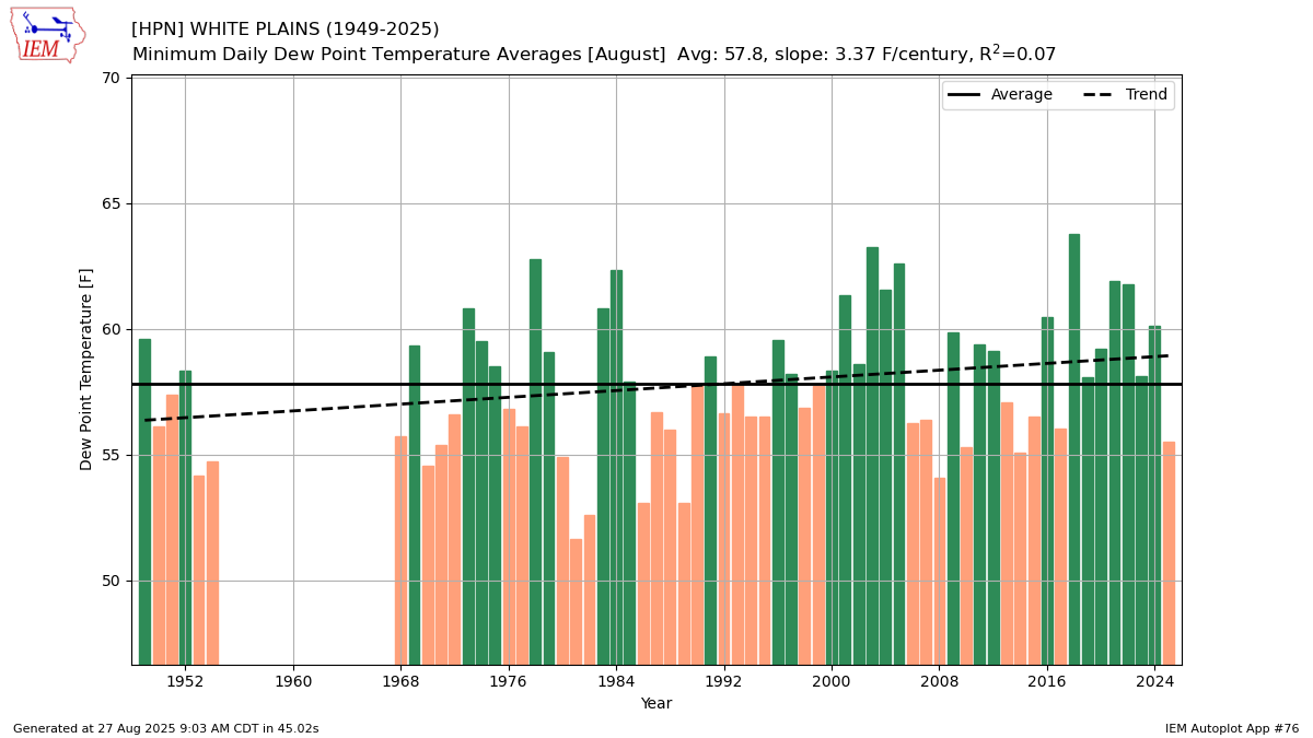
 The lowest August average minimum dewpoint since 2014 allowed the minimums to drive the cooler departures at spots like HPN which have been average for high temperatures. Climatological Data for WESTCHESTER CO AP, NY - August 2025 Click column heading to sort ascending, click again to sort descending. Sum 2123 1611 - - 2 187 2.39 Average 81.7 62.0 71.8 -1.0 - - - Normal 81.6 63.9 72.8 - 2 2025-08-01 73 61 67.0 -6.9 0 2 0.02 2025-08-02 79 58 68.5 -5.4 0 4 0.00 2025-08-03 82 57 69.5 -4.3 0 5 0.00 2025-08-04 87 60 73.5 -0.2 0 9 0.00 2025-08-05 82 66 74.0 0.4 0 9 0.00 2025-08-06 77 66 71.5 -2.1 0 7 T 2025-08-07 80 60 70.0 -3.5 0 5 T 2025-08-08 80 57 68.5 -4.9 0 4 0.00 2025-08-09 82 56 69.0 -4.3 0 4 0.00 2025-08-10 89 60 74.5 1.3 0 10 0.00 2025-08-11 88 63 75.5 2.4 0 11 0.00 2025-08-12 90 62 76.0 3.0 0 11 0.00 2025-08-13 90 69 79.5 6.6 0 15 1.16 2025-08-14 90 71 80.5 7.7 0 16 0.00 2025-08-15 86 71 78.5 5.8 0 14 0.00 2025-08-16 83 70 76.5 3.9 0 12 T 2025-08-17 90 70 80.0 7.5 0 15 T 2025-08-18 74 59 66.5 -5.8 0 2 0.00 2025-08-19 76 57 66.5 -5.7 0 2 0.00 2025-08-20 68 57 62.5 -9.6 2 0 1.17 2025-08-21 72 58 65.0 -7.0 0 0 0.04 2025-08-22 82 56 69.0 -2.8 0 4 0.00 2025-08-23 82 60 71.0 -0.7 0 6 0.00 2025-08-24 80 61 70.5 -1.0 0 6 0.00 2025-08-25 84 65 74.5 3.2 0 10 0.00 2025-08-26 77 61 69.0 -2.2 0 4 0.00 2025-08-27 M M M M M M M 2025-08-28 M M M M M M M 2025-08-29 M M M M M M M 2025-08-30 M M M M M M M 2025-08-31 M M M M M M M